Categories
Carimbologia T-Z

Villa Raffard (train station/Bahnhof), São Paulo (VSP-1495)

Companhia Sorocabana e Ytuana, 1898

Another name: Rafard (1929)

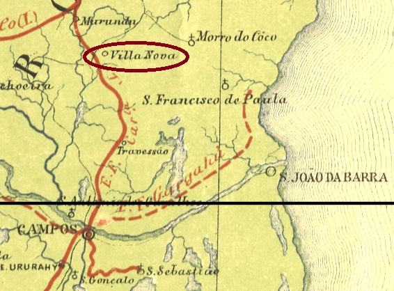
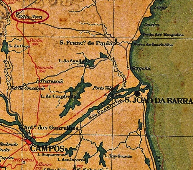
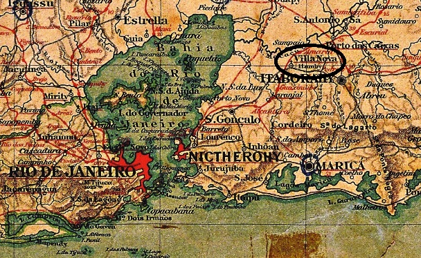
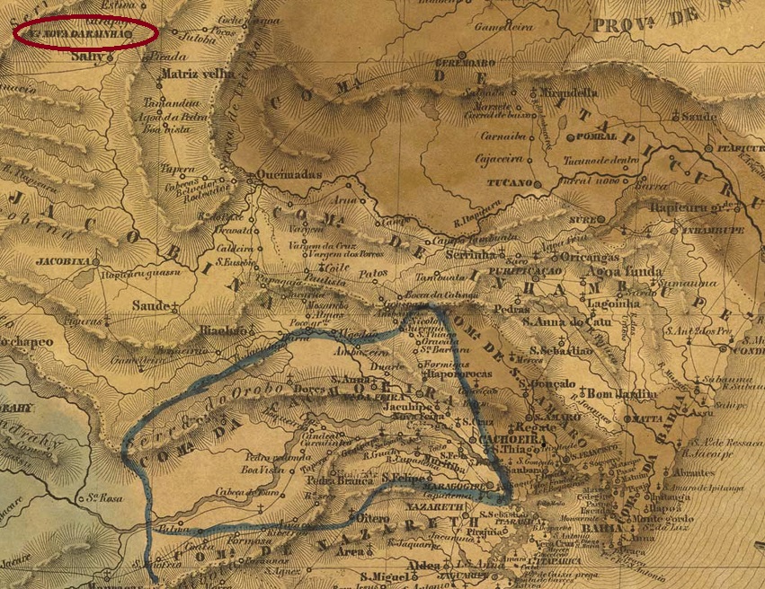
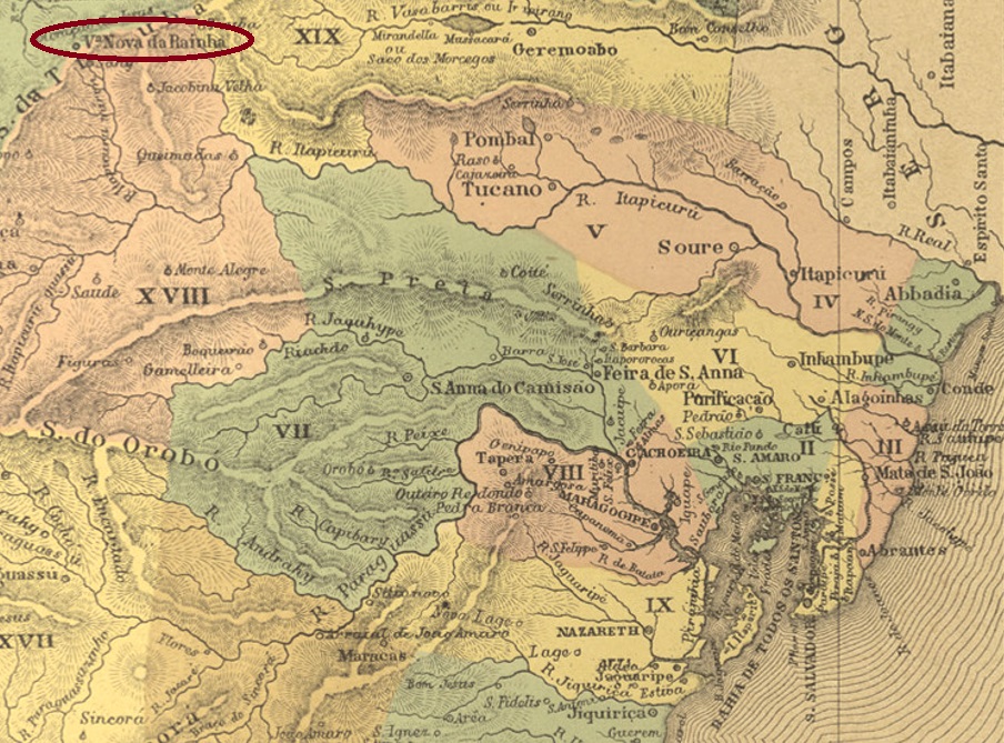
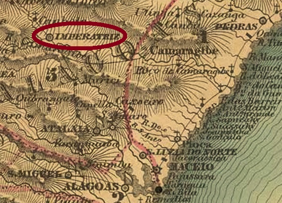
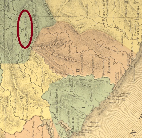
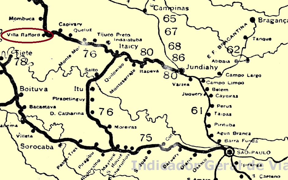
The present-day Município of Rafard began in 1883 as a workers’ settlement, housing mostly European immigrants contracted to the sugar cane processing factory Engenho Central de S. João do Capivary. Since both the factory and the settlement were model projects and were built upon personal initiative of Emperor D. Pedro II, the enterprise was particularly successful. The Villa Henrique Raffard was named after the company’s first director – Júlio Henrique Raffard (1851-1906), son of a Swiss consul in Rio – and was located on the south bank of the Capivary River, 140 km northwest of the provincial capital São Paulo. In November 1929, Raffard became a district of Capivary and has been a Município since February 1964. The sugar factory is still in operation today.

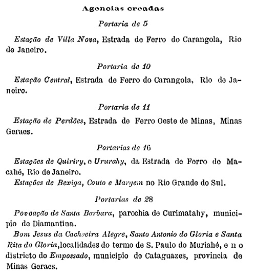
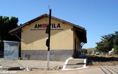
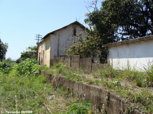
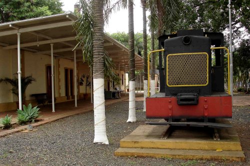
A Companhia Ytuana railway station (Piracicaba branch) was inaugurated there as early as September 1884. The railway line changed to the Cia. União Sorocabana e Ytuana in 1892 and to the Sorocabana Railway in 1907; from 1919 until its closure in 1971, it belonged to the Estrada de Ferro Sorocabana (estacoesferroviarias.com.br). Most recently, the station building served as the headquarters of the Municipal Culture and Tourism Office:

Photo: Carlos R. Almeida, 2008 (estacoesferroviarias.com.br)

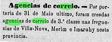
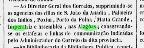
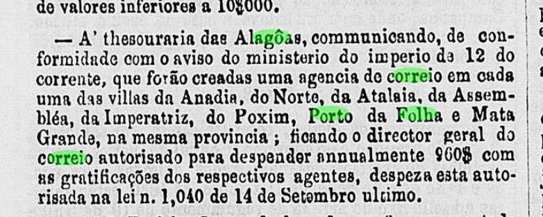
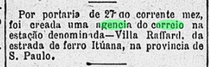
The station post office was established as early as August 1884 – before the station was built – according to the Rio press:

Gazeta de Noticias/RJ, 28/08/1884

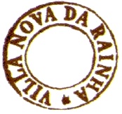
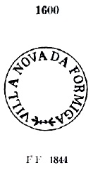
The oldest station postmark is VSP-1495a (Coll. José A. Junges): a double circle with the inscription EST. V. RAFFARD above and an ornament in cross below. The dates in the middle were found for the period 1884-1886. It was followed by VSP-1495b (Coll. José A. Junges): in this double circle the inscription above reads VILLA RAFFARD, and below it reads (S. PAULO). All dates in the middle are from the Republic so far: 1900-1904.

Anderer Name: Rafard (1929)

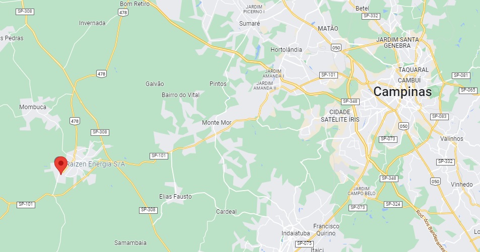
Der heutige Município von Rafard begann 1883 als eine Arbeitersiedlung, die meistens europäische Immigranten beherbergte, die an der Zuckerrohr-Verarbeitungsfabrik Engenho Central de S. João do Capivary unter Vertrag standen. Da sowohl Fabrik als auch Siedlung Modellprojektcharakter hatten und auf persönliche Initiative des Kaisers D. Pedro II entstanden sind, war das Unternehmen besonders erfolgreich. Die Villa Henrique Raffard wurde nach dem ersten Direktor der Firma genannt – Júlio Henrique Raffard (1851-1906), Sohn eines schweizerischen Konsuls in Rio – und lag am Südufer des Flusses Capivary, 140 km nordwestlich der Provinzhauptstadt São Paulo entfernt. Im November 1929 wurde Raffard ein Distrikt von Capivary und ist ein Município seit Februar 1964. Die Zuckerfabrik ist noch heute in Betrieb.

Bereits im September 1884 wurde dort ein Bahnhof der Companhia Ytuana (Piracicaba-Abzweigung) eingeweiht. Die Bahnlinie wechselte 1892 zur Cia. União Sorocabana e Ytuana und 1907 zur Sorocabana Railway; von 1919 bis zur Stilllegung 1971 gehörte sie der Estrada de Ferro Sorocabana (estacoesferroviarias.com.br). Zuletzt diente das Bahnhofsgebäude als Sitz des städtischen Kultur- und Tourismusamts:

Foto Carlos R. Almeida, 2008 (estacoesferroviarias.com.br)

Das Bahnhofspostamt wurde bereits im August 1884 – also noch vor dem Bahnhof – ins Leben gerufen, wie die Presse aus Rio mitteilte:

Gazeta de Noticias/RJ, 28.08.1884

Der älteste Poststempel des Bahnhofs ist VSP-1495a (Samml. José A. Junges): ein Doppelkreis mit der Inschrift EST. V. RAFFARD oben und einem Ornament in Kreuz unten. Die Daten in der Mitte wurden für den Zeitraum 1884-1886 gefunden. Ihm folgte VSP-1495b (Samml. José A. Junges): in diesem Doppelkreis lautet die obige Inschrift VILLA RAFFARD, unten liest man (S. PAULO). Alle Daten in der Mitte entstammen bisher der Republik: 1900-1904.

Categories
Carimbologia T-Z

Villa Nova, Sergipe (VSE-0185)

Atlas do Imperio do Brasil, 1868

Other names: Villa Nova de Santo Antonio, Neópolis (1940)

The freguesia of Villa Nova de Santo Antonio originated as early as October 1678 and was located on the south bank of the mythical São Francisco River, 120 km northeast of the future provincial capital Aracaju. In 1733, the place name changed for the first time, to Villa Nova d’El-Rey, and again three times after the colonial period: in March 1835 to Villa Nova do Rio São Francisco, in November 1910 to the town of Villa Nova, and finally in April 1940 to the present-day Neópolis.

Two years of origin for the local post office were found: first in December 1844, as Nova Monteiro writes in Administrações e Agencias Postaes do Brasil Imperio (Brasil Filatelico/RJ, 1934-5; Reprint SPP 1994-1999). Then again in 1848, as can be read in the Directory of Imperial Post Offices (Tabella das Agencias do Correio do Imperio, Rio de Janeiro, 1885). Unfortunately, no postmark of the imperial period could be assigned to this locality with certainty so far.

Villiers de l’Ile Adam: Carta (…) das Provincias de Pernambuco, Alagoas e Sergipe, 1848

Andere Namen: Villa Nova de Santo Antonio, Neópolis (1940)

Die Freguesia von Villa Nova de Santo Antonio entstand bereits im Oktober 1678 und lag am Südufer des mythischen Flusses São Francisco, 120 km nordöstlich der späteren Provinzhauptstadt Aracaju entfernt. 1733 wechselte der Ortsname erstmals, zu Villa Nova d’El-Rey, und nach der Kolonialzeit wieder dreimal: im März 1835 zu Villa Nova do Rio São Francisco, im November 1910 zur Stadt Villa Nova, schließlich im April 1940 zum heutigen noch aktuellen Neópolis.

Zwei Entstehungsjahre fürs örtliche Postamt wurden gefunden: erstmals im Dezember 1844, wie Nova Monteiro in Administrações e Agencias Postaes do Brasil Imperio (Brasil Filatelico/RJ, 1934-5; Reprint SPP 1994-1999) schreibt. Dann wieder 1848, wie im Verzeichnis der kaiserlichen Postämter (Tabella das Agencias do Correio do Imperio, Rio de Janeiro, 1885) zu lesen ist. Leider konnte bisher kein Poststempel der Kaiserzeit dieser Ortschaft mit Sicherheit zugeordnet werden.

Categories
Carimbologia T-Z

Villa Nova, Santa Catarina (VSC-0275)

Villiers de l’Ile Adam: Carta (…) da Provincia de Santa Catharina, 1848

Other names: Villa Nova de Sant’Anna, Henrique Lage, Imbituba (1927, 1938, 1959)

The freguesia of Villa Nova de Sant’Anna originated in 1811, belonging to the Vila of Laguna and was located barely 100 km south of the later provincial capital Desterro (now Florianópolis). In January 1927, the place was designated a district called Imbituba. The Indian word means many imbés (shrubs or climbing plants). After that, the place name changed four times: back to Villa Nova (1930), then to Henrique Lage (1949), in honour of the founder (1881-1941) of the port there. But the name Imbituba returned twice: in 1938 and 1959.

There had been a post office there since May 1881, as can be seen from the regional press:

O Despertador, 08.06.1881

No imperial-era postmark with this locality name has been seen so far.

Atlas do Imperio do Brasil, 1868

Andere Namen: Villa Nova de Sant’Anna, Henrique Lage, Imbituba (1927, 1938, 1959)

Die Freguesia von Villa Nova de Sant’Anna entstand 1811 bei der Vila von Laguna und lag knapp 100 km südlich der späteren Provinzhauptstadt Desterro (heute Florianópolis) entfernt. Im Januar 1927 wurde der Ort zu einem Distrikt namens Imbituba ernannt. Das indianische Wort bedeutet viele Imbés (Sträucher bzw. Kletterpflanzen). Danach wechselte der Ortsname viermal: zurück zu Villa Nova (1930), dann zu Henrique Lage (1949), zu Ehren vom Gründer (1881-1941) des dortigen Hafens. Aber der Name Imbituba kehrte zweimal zurück: 1938 und 1959.

Dort gab es ein Postamt seit Mai 1881, wie aus der Regionalpresse zu entnehmen ist:

O Despertador, 08.06.1881

Bisher war kein Poststempel der Kaiserzeit unter diesem Ortsnamen zu sehen.

Categories
Carimbologia T-Z

Villa Nova do Carangola (train station/Bahnhof), Rio de Janeiro (VRJ-2280)

E.F. Central do Brasil, 1890

Another name: Vila Nova de Campos (1960)

Villa Nova do Carangola railway station was inaugurated in April 1878 by the Estrada de Ferro do Carangola railway company and was in the Município of Campos, over 300 km northeast of the capital Rio de Janeiro. The railway line passed to E.F. Leopoldina in 1890 and belonged to Rede Ferroviária Federal S.A. from 1975 until its closure in 1996 (estacoesferroviarias.com.br). Around 1940, the station name changed to Morro do Coco. Today, the station building serves as the headquarters of a residents’ association:

Photo: Carlos Latuff, 2007 (in estacoesferroviarias.com.br)

The former Arraial of Villa Nova became a district of Campos in August 1891, which has been called Vila Nova de Campos since 1960.

The station post office was created in September 1889, as can be seen from Boletim Postal No.6 of that year:

Boletim Postal No.06, Oct./1889

The first station postmark is probably VRJ-2280a (Coll. Karlheinz Wittig): a double circle with the above inscription V. NOVA DO CARANGOLA and an ornament in X below. The dates in the centre have so far been found for the period 1893-1905.

Almanak Laemmert, 1892

Anderer Name: Vila Nova de Campos (1960)

Der Bahnhof Villa Nova do Carangola wurde im April 1878 durch die Estrada de Ferro do Carangola Bahngesellschaft eingeweiht und lag im Município von Campos, über 300 km nordöstlich der Hauptstadt Rio de Janeiro entfernt. Die Bahnlinie ging 1890 zur E.F. Leopoldina über und gehörte von 1975 bis zur Stilllegung 1996 der Rede Ferroviária Federal S.A. (estacoesferroviarias.com.br). Um 1940 wechselte der Bahnhofname zu Morro do Coco. Heute dient das Bahnhofsgebäude als Sitz eines Ortsvereins:

Foto: Carlos Latuff, 2007 (in estacoesferroviarias.com.br)

Aus der früheren Arraial von Villa Nova wurde im August 1891 ein Distrikt von Campos, der seit 1960 Vila Nova de Campos heißt.

Das Bahnhofspostamt entstand im September 1889, wie aus dem Boletim Postal Nr.6 d. J. hervorgeht:

Boletim Postal Nr. 6, Okt./1889

Der erste Bahnhofspoststempel ist wohl VRJ-2280a (Samml. Karlheinz Wittig): ein Doppelkreis mit der obigen Inschrift V. NOVA DO CARANGOLA und einem Ornament in X unten. Die Daten in der Mitte wurden bisher für den Zeitraum 1893-1905 gefunden.

Categories
Carimbologia T-Z

Villa Nova d’El-Rey, Ceará (VCE-0373)

Atlas do Imperio do Brasil, 1868

Other names: Villa Nova, Campo Grande, Inhussu, Guaraciaba do Norte (1951)

See also Campo Grande/CE and Ipu (R. Koester: Carimbologia VII and XXII)

Here we have another old village with a confused history. It began in 1760 with the construction of the chapel of Nossa Sra. dos Prazeres, which was located on the eastern slope of the Serra da Ibiapaba (or Serra Grande), barely 300 km west of the later provincial capital Fortaleza. In May 1791, the growing village called Campo Grande was elevated to Villa Nova d’El-Rey. After the colonial period, the royal name was no longer welcome, so in August 1840 the local administration changed to the neighbouring village of Ipu – now called Villa Nova do Ipú Grande. There must have been a strong rivalry between the two places, because immediately in January 1841 the old Villa Nova d’El-Rey became politically independent again, now as Villa de Campo Grande. This independence did not last long: in December 1842 Campo Grande was downgraded to the district of Ipu. And it remained so until January 1879, when the Vila of Campo Grande was created once again. After that, the place name changed twice: in December 1943 to Inhussu and in November 1951 to Guaraciaba do Norte, which is still current today. The name Guaraciaba has Indian origins and is said to mean golden hair.

The local post office was established in February 1832, as R. Koester writes in Carimbologia XXII. The year is confirmed in the Directory of Imperial Post Offices (Tabella das Agencias do Correio do Imperio, Rio de Janeiro, 1885). So far, no imperial postmark from this vila could be found.

Villiers de l’Ile Adam: Carta (…) da Provincia do Ceará, 1849

Andere Namen: Villa Nova, Campo Grande, Inhussu, Guaraciaba do Norte (1951)

Siehe auch Campo Grande/CE und Ipu (R. Koester: Carimbologia VII und XXII)

Hier haben wir wieder eine alte Ortschaft mit konfuser Geschichte. Diese fing 1760 mit der Errichtung der Kapelle Nossa Sra. dos Prazeres an, die am Osthang der Serra da Ibiapaba (oder auch Serra Grande) lag, knapp 300 km westlich der späteren Provinzhauptstadt Fortaleza entfernt. Im Mai 1791 wurde der wachsende Ort namens Campo Grande zur Villa Nova d’El-Rey erhoben. Nach der Kolonialzeit war der Königsname nicht mehr erwünscht, also wechselte im August 1840 die Ortsverwaltung zum Nachbarort Ipu – nun unter dem Namen Villa Nova do Ipú Grande. Es musste eine starke Rivalität zwischen beiden Orten vorhanden sein, denn gleich im Januar 1841 wurde die alte Villa Nova d’El-Rey wieder politisch selbständig, jetzt als Villa de Campo Grande. Diese Selbständigkeit dauerte nicht lange: im Dezember 1842 wurde Campo Grande zum Distrikt von Ipu herabgestuft. Und so blieb es bis Januar 1879, als die Vila von Campo Grande abermals ins Leben gerufen wurde. Danach wechselte der Ortsname zweimal: im Dezember 1943 zu Inhussu und im November 1951 zum heute noch aktuellen Guaraciaba do Norte. Der Name Guaraciaba hat indianischen Ursprung und soll goldene Haare bedeuten.

Das örtliche Postamt entstand im Februar 1832, wie R. Koester in Carimbologia XXII schreibt. Das Jahr wird im Verzeichnis der kaiserlichen Postämter (Tabella das Agencias do Correio do Imperio, Rio de Janeiro, 1885) bestätigt. Bisher konnte kein kaiserlicher Poststempel aus dieser Villa gefunden werden.

Categories
Carimbologia T-Z

Villa Nova (VRJ-0999) – Villa Nova de Itamby (train station/Bahnhof), Rio de Janeiro (VRJ-1000)

Atlas do Imperio do Brasil, 1868

See also Itambi (R. Koester: Carimbologia XXIII); São Bernabé (SRJ-0913); São José d’El Rei (SRJ-1427)

In November 1759 the freguesia of Nossa Senhora do Desterro de Itamby was founded in the now extinct municipality of Santo Antonio de Sá, located under 50 km northeast of the imperial capital. In 1772 it became a villa called São José del Rei, that after a short decadence went in 1833 as the freguesia of São Bernabé to the municipality of São João de Itaborahy. This status remained until 1840, when São Bernabé merged with other localities into the Villa Nova de Itamby, which is now Itambi, in the outskirts of the town of Itaboraí. We don’t know the causes of such a turbulent history, whether they are political, economic, or ecological nature, or even a combination among them.

After the closure of the post offices of São José d’El Rei (1835) and São Bernabé (around 1842), the village remained without a postal agency for about 30 years. The railway station of Villa Nova do Itamby was inaugurated in November 1866 by the Estrada de Ferro do Cantagallo railway company. The railway line switched to the E.F. Leopoldina in the early Republic and belonged to Rede Ferroviária Federal S.A. from 1975 until its closure in 1996 (estacoesferroviarias.com.br). Today the station is in ruins:

Photo: Cleyton Pieruccini, 2009 (in estacoesferroviarias.com.br)

Two years of creation for the station post office have been found. The Directory of Imperial Post Offices (Tabella das Agencias do Correio do Imperio, Rio de Janeiro, 1885) reads 1873, while Paulo Novaes gives April 1874 for it. Only one 19th century postmark has been seen under this name. VRJ-0999a (Collected by Fuad F. Filho) is a double circle with the above inscription VILLA NOVA. The only specimen bears a date from 1891 in the centre.

For postmarks with Itamby see Koester: Carimbologia XXIII).

Almanak Laemmert, 1892

Siehe auch Itambi (R. Koester: Carimbologia XXIII); São Bernabé (SRJ-0913); São José d’El Rei (SRJ-1427)

Die Geschichte dieser Ortschaft begann im November 1759 mit der Gründung der Freguesia von Nossa Senhora do Desterro de Itamby im inzwischen ausgelöschten Município von Santo Antonio de Sá, knapp 50 km nordöstlich der kaiserlichen Hauptstadt Rio de Janeiro gelegen. 1772 wurde daraus die Villa von São José del Rei, die nach einem raschen Verfall im Jahr 1833 zur Freguesia von São Bernabé im Município von São João de Itaborahy abstieg. Dieser Status hielt bis 1840, als São Bernabé mit anderen Ortschaften zur Villa Nova de Itamby (heute Itambi) wurde, heute ein Vorort der Stadt Itaboraí. Wir wissen nicht die Gründe für eine solch turbulente Geschichte, ob sie politischer, wirtschaftlicher oder ökologischer Natur sind, oder auch eine Mischung davon.

Nach der Schließung der Postämter von São José d’El Rei (1835) und São Bernabé (ca. 1842) blieb der Ort etwa 30 Jahre ohne Postagentur. Der Bahnhof von Villa Nova do Itamby wurde im November 1866 durch die Estrada de Ferro do Cantagallo Bahngesellschaft eingeweiht. Die Bahnlinie wechselte in der frühen Republik zur E.F. Leopoldina und gehörte von 1975 bis zur Stilllegung 1996 der Rede Ferroviária Federal S.A. (estacoesferroviarias.com.br). Heute ist der Bahnhof eine Ruine:

Foto: Cleyton Pieruccini, 2009 (in estacoesferroviarias.com.br)

Zwei Entstehungsjahre für das Bahnhofspostamt wurden gefunden. Im Verzeichnis der kaiserlichen Postämter(Tabella das Agencias do Correio do Imperio, Rio de Janeiro, 1885) liest man 1873, während Paulo Novaes gibt dafür den April 1874 an. Nur ein Poststempel des 19. Jahrhunderts war bisher unter diesem Namen zu sehen. VRJ-0999a (Samml. Fuad F. Filho) ist ein Doppelkreis mit der obigen Inschrift VILLA NOVA. Das einzige Exemplar trägt ein Datum aus 1891 in der Mitte.

Für Poststempel mit Itamby siehe Koester: Carimbologia XXIII.

Categories
Carimbologia T-Z

Villa Nova da Rainha, Paraíba (VPB-0295)

Atlas do Imperio do Brasil, 1868

Other name: Campina Grande

See also Campina Grande (R. Koester: Carimbologia VIII)

The freguesia of N. Sra. da Conceição de Campina Grande was established in 1769, situated 120 km west of the future provincial capital Parahyba do Norte (today: João Pessoa). It was promoted to Villa Nova da Rainha by royal decree (Alvará Real) in August 1788 and retained this name for almost 80 years. It was not until October 1864, when it was granted city status, that it was renamed Campina Grande.

There had been a post office there since May 1829, as can be read both in the postal report (Relatorio Postal) for 1887 and in the directory of imperial post offices (Tabella das Agencias do Correio do Imperio, Rio de Janeiro, 1885). So far, no postmark with the old place name has turned up. For postmarks with Campina Grande see Koester, Carimbologia VIII.

Villiers de l’Ile Adam: Carta (…) das Provincias do Rio Grande do Norte e Parahiba, 1848

Anderer Name: Campina Grande

Siehe auch Campina Grande (R. Koester: Carimbologia VIII)

Die Freguesia von N. Sra. da Conceição de Campina Grande wurde 1769 errichtet und lag 120 km westlich der künftigen Provinzhauptstadt Parahyba do Norte (heute: João Pessoa) entfernt. Sie stieg im August 1788 durch königliche Verfügung (Alvará Real) zur Villa Nova da Rainha auf und behielt diesen Namen immerhin fast 80 Jahre lang. Erst im Oktober 1864, bei der Vergabe des Stadt-Status, wurde der Ort zu Campina Grande umbenannt.

Dort gab es ein Postamt seit Mai 1829, wie man sowohl im Postbericht (Relatorio Postal) für 1887 als auch im Verzeichnis der kaiserlichen Postämter (Tabella das Agencias do Correio do Imperio, Rio de Janeiro, 1885) lesen kann. Bisher ist noch kein Poststempel mit der alten Ortsbezeichnung aufgetaucht. Für Stempel mit Campina Grande siehe Koester, Carimbologia VIII.

Categories
Carimbologia T-Z

Villa Nova da Rainha, Bahia (VBA-0790)

Villiers de l’Ile Adam: Carta (…) da Provincia da Bahia, 1848

Other names: Senhor do Bomfim da Tapera, Senhor do Bonfim (1943)

See also Bomfim/BA (R. Koester: Carimbologia V)

The settlement called Arraial de Senhor do Bomfim da Tapera was founded in 1750 and was situated on the south bank of the river Itapicuru, 380 km northwest of the later provincial capital Salvador da Bahia. In July 1797, by royal decree (Carta Régia), it was elevated to Villa Nova da Rainha. In May 1885 – by which time the Portuguese queen was barely remembered – it became the town of Bomfim, which has been called Senhor do Bonfim since December 1943.

Two opening dates for the local post office were found. First in March 1836, as Nova Monteiro writes in Administrações e Agencias Postaes do Brasil Imperio (Brasil Filatelico/RJ, 1934-5; Reprint SPP 1994-1999). Then again in 1846, as can be read in the Directory of Imperial Post Offices (Tabella das Agencias do Correio do Imperio, Rio de Janeiro, 1885). The oldest postmark is VBA-0790a, which was probably used from 1836 onwards and was already presented in the RHM catalogue:

VBA-0790a (RHM P-BA-09)

It was followed by VBA-0790b, which was used from about 1843 until at least 1846 and can also be seen in the RHM catalogue:

VBA-0790b (RHM)

The last postmark in the Empire is VBA-0790c (Coll. José A. Junges): a double circle with the inscription V.N. DA RAINHA above. The dates in the centre go from 1882 to 1891.

Atlas do Imperio do Brasil, 1868

Andere Namen: Senhor do Bomfim da Tapera, Senhor do Bonfim (1943)

Siehe auch Bomfim/BA (R. Koester: Carimbologia V)

Die Siedlung namens Arraial de Senhor do Bomfim da Tapera entstand 1750 und lag am Südufer des Flusses Itapicuru, 380 km nordwestlich der späteren Provinzhauptstadt Salvador da Bahia. Im Juli 1797 erfolgte durch Königliche Verfügung (Carta Régia) der Aufstieg zur Villa Nova da Rainha. Im Mai 1885 – da war die portugiesische Königin kaum noch in Erinnerung – wurde daraus die Stadt von Bomfim, die seit Dezember 1943 Senhor do Bonfim heißt.

Zwei Eröffnungsdaten fürs örtliche Postamt wurden gefunden. Erstmals im März 1836, wie Nova Monteiro in Administrações e Agencias Postaes do Brasil Imperio (Brasil Filatelico/RJ, 1934-5; Reprint SPP 1994-1999) schreibt. Dann wieder 1846, wie im Verzeichnis der kaiserlichen Postämter (Tabella das Agencias do Correio do Imperio, Rio de Janeiro, 1885) zu lesen ist. Der älteste Poststempel ist VBA-0790a, der wohl ab 1836 Verwendung fand und bereits im RHM-Katalog vorgestellt wurde:

VBA-0790a (RHM P-BA-09)

Ihm folgte VBA-0790b, der ab ca. 1843 bis zumindest 1846 gebraucht wurde und auch im RHM-Katalog zu sehen ist:

VBA-0790b (RHM)

Der letzte Poststempel im Kaiserreich ist VBA-0790c (Samml. José A. Junges). Ein Doppelkreis mit der obigen Inschrift V.N. DA RAINHA. Die Daten in der Mitte gehen zunächst von 1882 bis 1891.

Categories
Carimbologia T-Z

Villa Nova da Imperatriz, Alagoas (VAL-0075)

Villiers de l’Ile Adam: Carta (…) das Provincias de Pernambuco, Alagoas e Sergipe, 1848

Other names: Santa Maria Magdalena, União, União dos Palmares

See also Imperatriz/AL (R. Koester: Carimbologia XXII)

The former freguesia of Santa Maria Magdalena was located near the vila of Atalaia on the east bank of the river Mundaú, 75 km northwest of the provincial capital Maceió. In October 1831, the place became Villa Nova da Imperatriz. In July 1876, it was downgraded to the district of Atalaia, but regained villa status nine years later and became a town in August 1889. After the military coup that introduced the Republic, the empress was not even tolerated as a place name, and the town was renamed União (Unity) in September 1890. Since December 1943, it has been the Municipio of União dos Palmares, in memory of the quilombo (refuge for escaped slaves) that existed there from 1580 to 1694.

Three periods of operation for the local post office were found. A first opening is said to have taken place around 1835, as Aldo Cardoso writes in Contribuição para a História dos Correios de Alagoas (Maceió, 1969). The second period began in 1845, as both Cardoso and the Directory of Imperial Post Offices (Tabella das Agencias do Correio do Imperio, Rio de Janeiro, 1885) record, and ended in October 1847, according to the Official Press in Rio:

Gazeta Official/RJ, 13/10/1847

The agency was created for the third time in November 1859, according to a report by the Imperial Ministry:

Boletim do Ministerio do Imperio/14.11.1859

So far, unfortunately, no postmark of the imperial period could be assigned to this locality with certainty.

Atlas do Imperio do Brasil, 1868

Andere Namen: Santa Maria Magdalena, União, União dos Palmares

Siehe auch Imperatriz/AL (R. Koester: Carimbologia XXII)

Die ehemalige Freguesia von Santa Maria Magdalena lag bei der Vila von Atalaia am Ostufer des Flusses Mundaú, 75 km nordwestlich der Provinzhauptstadt Maceió. Im Oktober 1831 wurde der Ort zur Villa Nova da Imperatriz. Im Juli 1876 wurde die Villa zum Distrikt von Atalaia herabgestuft, erlangte aber neun Jahre später den Villa-Status wieder und wurde im August 1889 eine Stadt. Nach dem Militärputsch, der die Republik einführte, wurde die Kaiserin nicht mal als Ortsbezeichnung toleriert, und die Stadt wurde im September 1890 zu União (Eintracht) umbenannt. Seit Dezember 1943 ist es der Municipio von União dos Palmares, in Erinnerung an den Quilombo (Zufluchtstätte für geflohene Sklaven), der dort von 1580 bis 1694 existierte.

Drei Betriebsperioden fürs örtliche Postamt wurden gefunden. Eine erste Eröffnung soll ca. 1835 stattgefunden haben, wie Aldo Cardoso in Contribuição para a História dos Correios de Alagoas (Maceió, 1969) schreibt. Die zweite Periode fing 1845 an, wie sowohl Cardoso als auch das Verzeichnis der kaiserlichen Postämter (Tabella das Agencias do Correio do Imperio, Rio de Janeiro, 1885) registrieren, und endete im Oktober 1847, wie aus der Amtspresse in Rio hervorgeht:

Gazeta Official/RJ, 13.10.1847

Die Agentur wurde im November 1859 zum dritten Mal ins Leben gerufen, laut Bericht des Imperialministeriums:

Boletim do Ministerio do Imperio/14.11.1859

Bisher konnte leider kein Poststempel der Kaiserzeit dieser Ortschaft mit Sicherheit zugeordnet werden.

Categories
Carimbologia T-Z

Villa da Formiga (VMG-3644) – Villa Nova da Formiga, Minas Gerais (VMG-3645)

Atlas do Imperio do Brasil, 1868

See also Formiga (R. Koester: Carimbologia XIX)

The parish of S. Vicente Ferrer da Formiga was established in July 1832 in the município of Tamanduá, 290 km west of the provincial capital Ouro Preto. There was no danger to the ant (Formiga) from the anteater (Tamanduá) because the Serra Geral lies between both. In March 1839, the village rose to become Villa Nova da Formiga, and has been a town since June 1858.

Both Paula Sobrinho (História Postal de Minas Gerais, Belo Horizonte, 1997) and Reinhold Koester (Carimbologia XIX) agree that the local post office was created in March 1840. Two early postmarks have already been recorded. VMG-3644a also exists in sepia, was used from 1840 to at least 1843 and is known through the RHM catalogue:

VMG-3644a (RHM P-MG-28)

Its successor VMG-3645a was in use from about 1843 and was already known by Paulo Ayres (Catálogo de Carimbos Brasil-Império, S. Paulo, 1937, 1942) with no. 1600:

VMG-3645a (P.A.1600) 1843ff-1846

Later postmarks bear only the place name FORMIGA and have already been presented by Koester (op. cit.).

Villiers de l’Ile Adam: Carta (…) da Provincia de Minas Geraes, 1849

Siehe auch Formiga (R. Koester: Carimbologia XIX)

Die Pfarrei von S. Vicente Ferrer da Formiga wurde im Juli 1832 im Município von Tamanduá errichtet und lag 290 km westlich der Provinzhauptstadt Ouro Preto entfernt. Da bestand für die Ameise (Formiga) keine Gefahr durch den Ameisenbär (Tamanduá), denn zwischen beiden liegt die Serra Geral. Im März 1839 stieg der Ort zur Villa Nova da Formiga auf, und ist seit Juni 1858 eine Stadt.

Sowohl Paula Sobrinho (História Postal de Minas Gerais, Belo Horizonte, 1997) als auch Reinhold Koester (Carimbologia XIX) sind sich darüber einig, dass das örtliche Postamt im März 1840 entstanden ist. Zwei frühe Poststempel sind bereits erfasst. VMG-3644a gibt es auch in sepia, wurde von 1840 bis zumindest 1843 verwendet und ist durch den RHM-Katalog bekannt:

VMG-3644a (RHM P-MG-28)

Sein Nachfolger VMG-3645a war ab ca. 1843 in Gebrauch und wurde bereits durch Paulo Ayres (Catálogo de Carimbos Brasil-Império, S. Paulo, 1937, 1942) mit Nr. 1600 bekannt:

VMG-3645a (P.A.1600) 1843ff-1846

Spätere Poststempel tragen lediglich die Ortsbezeichnung FORMIGA und sind durch Koester (op. cit.) bereits vorgestellt.