Categories
Carimbologia T-Z

Villa do Cruzeiro, São Paulo (VSP-0405)

Atlas do Imperio do Brasil, 1868

Other names: Conceição do Embaú, Conceição do Cruzeiro, Vila Novais

See also Cruzeiro/SP (R. Koester: Carimbologia XIV)

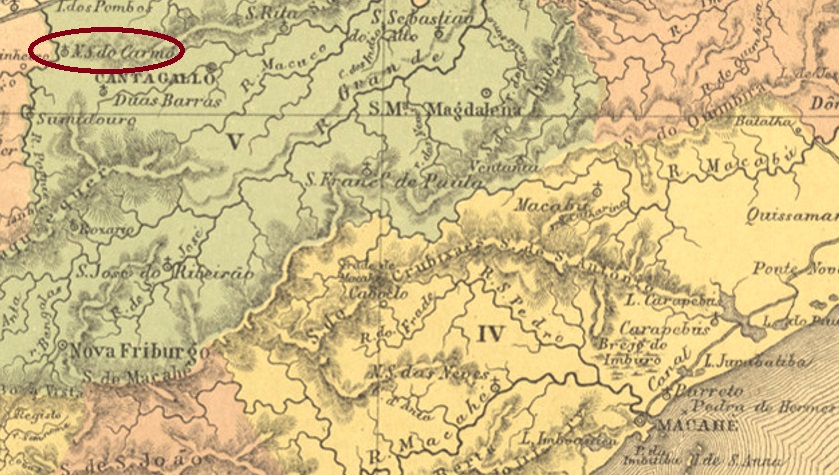
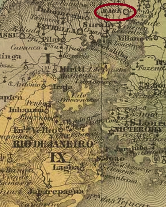
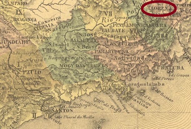
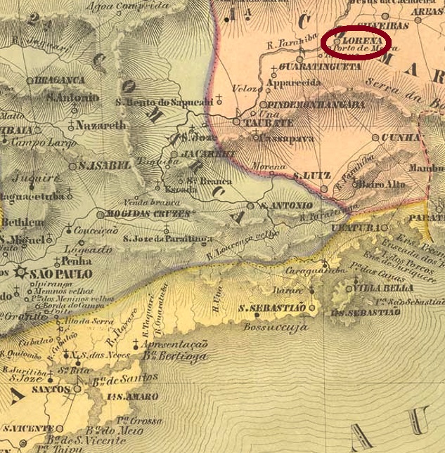
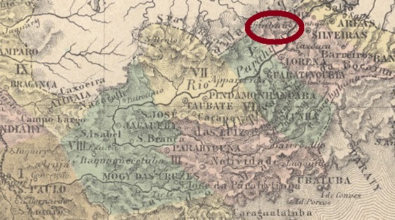
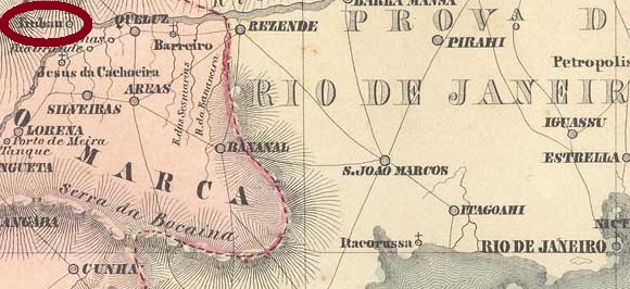
The freguesia of N. Sra da Conceição do Embaú (also spelled Imbahú) was founded in February 1846 and was located on the west bank of the Paraíba do Sul River in the município of Lorena, 220 km northeast of the provincial capital São Paulo. In March 1871, the town was elevated to the status of a vila under the name Conceição do Cruzeiro. After the inauguration of a railway station of the E.F. Dom Pedro II Railway Company in March 1878, the village moved to and from the station several times and in between was given the name Villa Novais. Cruzeiro has been a city since December 1906.

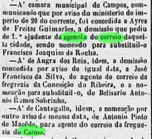
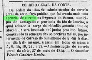
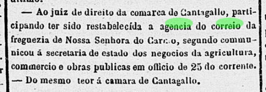
As listed in the Directory of Imperial Post Offices (Tabella das Agencias do Correio do Imperio, Rio de Janeiro, 1885), there had been a post office there since 1876. The regional press reported the appointment of the local postal agent in the last week of that year:

Correio Paulistano, 11.01.1877

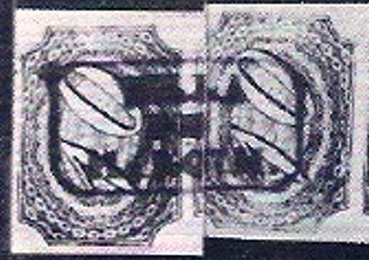
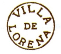
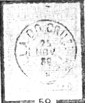
After the ascent to the Vila, VSP-0405a appeared, previously found with dates between 1887 and 1889 and already shown by R. Koester (Carimbologia XIV):

VSP-0405a (RK) 1887-1889

Koester (op. cit.) also shows three earlier cancellations, all bearing the simplified place name CRUZEIRO.

Villiers de l’Ile Adam: Carta (…) da Provincia de São Paulo, 1847

Andere Namen: Conceição do Embaú, Conceição do Cruzeiro, Vila Novais

Siehe auch Cruzeiro/SP (R. Koester: Carimbologia XIV)

Die Freguesia von N. Sra da Conceição do Embaú (auch Imbahú geschrieben) wurde im Februar 1846 gegründet und lag am Westufer des Flusses Paraíba do Sul im Município von Lorena, 220 km nordöstlich der Provinzhauptstadt São Paulo entfernt. Im März 1871 wurde der Ort unter dem Namen Conceição do Cruzeiro zur Vila erhoben. Nach der Einweihung eines Bahnhofs der E.F. Dom Pedro II Bahngesellschaft im März 1878 wechselte der Ort mehrmals zum und vom Bahnhof und bekam zwischendurch den Namen Villa Novais. Seit Dezember 1906 ist Cruzeiro eine Stadt.

Wie im Verzeichnis der kaiserlichen Postämter (Tabella das Agencias do Correio do Imperio, Rio de Janeiro, 1885) aufgelistet, gab es dort ein Postamt seit 1876. Die Regionalpresse berichtete über die Ernennung des örtlichen Postagenten in der letzten Jahreswoche:

Correio Paulistano, 11.01.1877

Nach dem Aufstieg zur Vila erschien VSP-0405a, der bisher mit Daten zwischen 1887 und 1889 gefunden und bereits durch R. Koester (Carimbologia XIV) gezeigt wurde:

VSP-0405a (RK) 1887-1889

Koester (op. cit.) zeigt ebenfalls drei frühere Entwertungen, alle tragen die vereinfachte Ortsbezeichnung CRUZEIRO.

Categories
Carimbologia T-Z

Villa do Corrente, Piauí (VPI-0066)

Atlas do Imperio do Brasil, 1868

See also Corrente (R. Koester: Carimbologia XIV)

The parish of N. Sra da Conceição do Corrente was erected in August 1860 in the Município of Parnaguá and was situated on the north bank of the Corrente River, 840 km south of the provincial capital Teresina. In December 1872, it was elevated to the status of vila.

In the Directory of Imperial Post Offices (Tabella das Agencias do Correio do Imperio, Rio de Janeiro, 1885), one reads that there had been a post office there since 1883. However, this is probably either a transcription error or a reopening, because a postal agency was already asked for there in April 1879…

A Imprensa/PI/ 28.04.1879

… and in February 1880 a postal clerk was named there after the death of the predecessor:

A Imprensa/PI/ 25.02.1880

The oldest postmark here is VPI-0066a (image from the internet): the only specimen so far shows a double circle with the inscriptions VILLA DO CORRENTE above and (PIAUHY) below. The date inside is from 1894.

Arthur D. Ribeiro: Estado do Piauhy, 1924

Siehe auch Corrente (R. Koester: Carimbologia XIV)

Die Pfarrei von N. Sra da Conceição do Corrente wurde im August 1860 im Município von Parnaguá errichtet und lag am Nordufer des Flusses Corrente, 840 km südlich der Provinzhauptstadt Teresina entfernt. Im Dezember 1872 erfolgte der Aufstieg zur Vila.

Im Verzeichnis der kaiserlichen Postämter (Tabella das Agencias do Correio do Imperio, Rio de Janeiro, 1885) liest man, dass es dort seit 1883 ein Postamt gab. Das dürfte aber entweder ein Abschreibfehler oder eine Wiedereröffnung sein, denn bereits im April 1879 wurde dort eine Postagentur beantragt…

A Imprensa/PI/ 28.04.1879

… und im Februar 1880 wurde ein Postangestellter dort nach dem Tod des Vorgängers genannt:

A Imprensa/PI/ 25.02.1880

Der älteste Poststempel hier ist VPI-0066a (Abb. aus dem Internet): das bisher einzige Exemplar zeigt einen Doppelkreis mit den Inschriften VILLA DO CORRENTE oben und (PIAUHY) unten. Das Datum im Inneren ist aus dem Jahr 1894.

Categories
Carimbologia T-Z

Villa do Carmo, Rio de Janeiro (VRJ-0995)

Atlas do Imperio do Brasil, 1868

Other names: Arraial de N.Sa. do Monte do Carmo, Carmo de Cantagallo

See also Carmo (R. Koester: Carimbologia IX)

The Arraial of N. Sra. do Monte do Carmo (Our Lady of Carmel Mountain) was in the Município of Cantagalo almost 200 km northwest of the capital Rio de Janeiro and became a district in October 1845, a vila in October 1881 and the town of Carmo in December 1889.

As for the origin of the local post office, there is some ambiguity here, as many dates are available. The Directory of Imperial Post Offices (Tabella das Agencias do Correio do Imperio, Rio de Janeiro, 1885) writes 1853 for it, and this is likely to be correct, as the Rio press reports a December 1853 appointment of the local postal clerk:

Diario do Rio de Janeiro, 09.01.1854_exped 23.12.1853

However, a few months later, another opening of the same post office with the same clerk was reported:

Diario do Rio de Janeiro, 30.05.1854

This second date coincides almost exactly with Paulo Novaes’s date of origin for June 1854, as can be read in agenciaspostais.com.br. But sometime around 1860, the post office was closed, as news of its reopening came in August 1861:

Correio Mercantil, 18.08.1861

After the ascent to the villa in October 1881, the postmark VRJ-0995a appeared (image from the Internet): a double circle with the inscription VILLA DO CARMO at the top and an ornament at the bottom, reminiscent of a wide X cut by two vertical strokes. Dates in the centre go from 1889 to 1890. For earlier postmarks see R. Koester’s Carimbologia IX.

Villiers de l’Ile Adam: Carta (…) da Provincia do Rio de Janeiro, 1850

Andere Namen: Arraial de N.Sa. do Monte do Carmo, Carmo de Cantagallo

Siehe auch Carmo (R. Koester: Carimbologia IX)

Der Arraial von N. Sra. do Monte do Carmo (Unsere Liebe Frau aus dem Carmelberg) lag im Município von Cantagalo knapp 200 km nordwestlich der Hauptstadt Rio de Janeiro und wurde im Oktober 1845 ein Distrikt, im Oktober 1881 eine Vila und im Dezember 1889 die Stadt Carmo.

Was die Entstehung des örtlichen Postamts betrifft, gibt es hier einige Unklarheiten, da viele Daten vorhanden sind. Das Verzeichnis der kaiserlichen Postämter (Tabella das Agencias do Correio do Imperio, Rio de Janeiro, 1885) schreibt dafür 1853, und das wird wohl stimmen, da die Presse aus Rio über eine Ernennung des Postangestellten vor Ort zum Dezember 1853 berichtet:

Diario do Rio de Janeiro, 09.01.1854_exped 23.12.1853

Allerdings wurde ein Paar Monate später wieder eine Eröffnung desselben Postamts mit demselben Angestellter:

Diario do Rio de Janeiro, 30.05.1854

Dieser zweite Termin deckt sich fast genau mit Paulo Novaes Entstehungsangabe für den Juni 1854, wie in agenciaspostais.com.br zu lesen ist. Aber irgendwann um 1860 wurde das Postamt geschlossen, denn im August 1861 kam die Meldung über seine Wiedereröffnung:

Correio Mercantil, 18.08.1861

Nach dem Aufstieg zur Villa im Oktober 1881 erschien der Poststempel VRJ-0995a (Abb. aus dem Internet): ein Doppelkreis mit der Inschrift VILLA DO CARMO oben und einem Ornament unten, das an einem breiten X erinnert, das durch zwei vertikale Striche geschnitten wird. Daten in der Mitte von 1889 bis 1890. Für frühere Poststempel siehe R. Koesters Carimbologia IX.

Categories
Carimbologia T-Z

Villa de São Francisco, Bahia (VBA-0780)

Atlas do Imperio do Brasil, 1868

Other names: Villa de Sao Francisco da Barra do Sergipe do Conde, S. Francisco do Conde (1943)

In November 1697 a villa was founded in Bahia, bearing the sonorous name of S. Francisco da Barra do Sergipe do Conde. It was in the north of All Saints’ Bay, less than 70 km northwest of the provincial capital Salvador. In June 1931, the place name was simplified to S. Francisco, to which an additional do Conde came in December 1943.

As can be read in the 1885 Imperial Mail Register (Tabella das Agencias do Correio do Imperio), there is a post office on place since 1872. This is confirmed by the provincial president’s report of March 1873:

Relatorio do Presidente da Provincia

The only imperial postmark so far is the French-type SBA-0815a (Coll. Fuad Ferreira Fo.), which so far was found with postmarks between 1880 and 1901:

SBA-0815a (FF), 1880-1901
Villiers de l’Ile Adam: Carta (…) da Provinica da Bahia, 1848

Andere Namen: Villa de São Francisco da Barra do Sergipe do Conde, S. Francisco do Conde (1943)

In der Provinz Bahia wurde bereits im November 1697 eine Villa gegründet, die den sonoren Namen São Francisco da Barra do Sergipe do Conde trug. Sie lag im Norden der Allerheiligenbucht, knapp 70 km nordwestlich der Provinzhauptstadt Salvador entfernt. Im Juni 1931 wurde der Ortsnamen zu São Francisco vereinfacht, der aber seit Dezember 1943 wieder den Zusatz do Conde trägt.

Wie im Verzeichnis der kaiserlichen Postämter (Tabella das Agencias do Correio do Imperio) von 1885 zu lesen ist, gibt es dort eine Postagentur seit 1872. Dieses wird durch den Bericht des Provinzpräsidenten im März 1873 bestätigt:

Relatorio do Presidente da Provincia

Der bisher einzige kaiserliche Poststempel ist der französische Typ SBA-0815a (Samml. Fuad Ferreira Fo.), der bisher mit Daten zwischen 1880 und 1901 gefunden wurde:

SBA-0815a (FF), 1880-1901

Categories
Carimbologia T-Z

Villa de Patos, Paraíba (VPB-0285)

Atlas do Imperio do Brasil, 1868

See also Patos/PB (R. Koester: Carimbologia XXX)

The freguesia of N. Sra. da Guia de Patos was founded in 1788 in the villa of Pombal and was situated on the west bank of the river Espinharas, 310 km west of the future provincial capital Parahyba do Norte (today: João Pessoa). The place was elevated to vila in December 1832 and to town in October 1903.

As Nova Monteiro writes in Administrações e Agencias Postaes do Brasil Imperio (in Brasil Filatelico/RJ, 1934-5; reprint SPP 1994-1999), the local post office was established as early as June 1833. Unfortunately, the only 19th century postmark so far is not the oldest. VPB-0285b (Coll. Dieter Kerkhoff) is a double circle with the inscription VILLA DE PATOS on top and an ornament in an oval below, open in four points. The dates in the centre are from the period 1891-1894 and were partly entered by hand.

Villiers de l’Ile Adam: Carta (…) das Provincias do Rio Grande do Norte e Parahiba, 1848

Siehe auch Patos/PB (R. Koester: Carimbologia XXX)

Die Freguesia von N. Sra. da Guia de Patos wurde 1788 in der Villa von Pombal gegründet und lag am Westufer des Flusses Espinharas, 310 km westlich der künftigen Provinzhauptstadt Parahyba do Norte (heute: João Pessoa) entfernt. Der Ort wurde im Dezember 1832 zur Vila und im Oktober 1903 zur Stadt erhoben.

Wie Nova Monteiro in Administrações e Agencias Postaes do Brasil Imperio (in Brasil Filatelico/RJ, 1934-5; Reprint SPP 1994-1999) schreibt, entstand das örtliche Postamt bereits im Juni 1833. Das bisher einzige Poststempel aus dem 19. Jahrhundert ist leider nicht der älteste. VPB-0285b (Samml. Dieter Kerkhoff) ist ein Doppelkreis mit der Inschrift VILLA DE PATOS oben und einem Ornament im Oval unten, das an vier Stellen offen ist. Die Daten in der Mitte entstammen dem Zeitraum 1891-1894 und wurden teilweise per Hand eingetragen.

Categories
Carimbologia T-Z

Villa de Pitangui, Minas Gerais (VMG-3785)

Atlas do Imperio do Brasil, 1868

See also Pitangui (R. Koester: Carimbologia XXXI)

This settlement arose in the 17th century after gold miners found the precious metal at Descoberto Mountain, over 200 km northwest of the later provincial capital Ouro Preto. The village grew so rapidly that villa status was achieved in February 1715 as Villa Nova do Infante das Minas do Pitangui, nine years earlier than the designation as Freguesia of N. Sra. do Pilar de Pitangui. Pitangui has been a town since May 1855.

Two years of origin for the local post office could be found. First in March 1798, as Paula Sobrinho writes in História Postal de Minas Gerais (Belo Horizonte, 1997). Then again in March 1829, as R. Koester reports in Carimbologia XXXI. VMG-3785a is so far the oldest cancel; it also occurs in sepia, brown and green between 1836 and 1848 and was already presented by Paulo Ayres in Catálogo de Carimbos Brasil-Império (S. Paulo, 1937, 1942) under no. 1164 and also in the RHM catalogue under P-MG-46. Since the spelling erroneously shows a Y (instead of I), here are both images:

VMG-3785a (P.A. 1164 recte – RHM P-MG-46)

Later postmarks bear the place name Pitangui or Pitanguy, without mentioning Villa.

Villiers de l’Ile Adam: Carta (…) da Provincia de Minas Geraes, 1849

Siehe auch Pitangui (R. Koester: Carimbologia XXXI)

Diese Siedlung entstand im 17. Jahrhundert, nachdem Goldgräber das Edelmetall am Descoberto-Berg gefunden haben, über 200 km nordwestlich der späteren Provinzhauptstadt Ouro Preto entfernt. Die Ortschaft wuchs so rasch, dass der Villa-Status im Februar 1715 als Villa Nova do Infante das Minas das Minas do Pitangui erreicht wurde, neun Jahre früher als die Ernennung zur Freguesia von N. Sra. do Pilar de Pitangui. Seit Mai 1855 ist Pitangui eine Stadt.

Zwei Entstehungsjahre fürs örtliche Postamt waren zu finden. Erstmals im März 1798, wie Paula Sobrinho in História Postal de Minas Gerais (Belo Horizonte, 1997) schreibt. Dann im März 1829, wie R. Koester in Carimbologia XXXI berichtet. VMG-3785a ist bisher der älteste Stempel; er kommt auch in sepia, braun und grün zwischen 1836 und 1848 vor und wurde bereits von Paulo Ayres in Catálogo de Carimbos Brasil-Império (S. Paulo, 1937, 1942) unter Nr. 1164 und auch im RHM-Katalog unter P-MG-46 vorgestellt. Da die Schreibweise irrtümlich ein Y (statt I) zeigt, hier beide Abbildungen:

VMG-3785a (P.A. 1164 recte RHM P-MG-46)

Spätere Poststempel tragen die Ortsbezeichnung Pitangui oder Pitanguy, ohne Villa zu erwähnen.

Categories
Carimbologia T-Z

Villa de Maroim, Sergipe (VSE-0210)

Villiers de l’Ile Adam: Carta (…) das Provincias de Pernambuco, Alagoas e Sergipe, 1848

Another name: Maruim

See also Maroim (R. Koester: Carimbologia XXVII)

Maruim is the indigenous name for many species of mosquitoes in Brazil. There were plenty of them on the north bank of the Sergipe River, so that the settlement received this name from about 1800. It was in the area of the Vila of Santo Amaro das Brotas, about 30 km north of the later provincial capital of Aracaju. The first years of settlement were marked by many disputes, some violent, among the political chiefs of the region, which did not come to an end even after Maroim was elevated to villa status in February 1835. It was not until May 1854, when Maroim was elevated to town, that peace returned.

Two years of origin for the local post office were found. First in December 1844, as Nova Monteiro writes in Administrações e Agencias Postaes do Brasil Imperio (Brasil Filatelico/RJ, 1934-5; Reprint SPP, 1994-1999). Then also in 1848, as can be seen from the Directory of Imperial Post Offices (Tabella das Agencias do Correio do Imperio, Rio de Janeiro, 1885). The earliest postmark is VSE-0210a, which was used from the 1844 numeral issue onwards, as can be read in Koester’s Carimbologia XXVII:

VSE-0210a (RK)

Another postmark is often assigned to this locality – also by the renowned RHM catalogue. However, this is a misinterpreted postmark from Mariana in Minas Gerais:

“Maroim” (RHM) – Mariana/MG (R. Koester: Carimbologia XXVII).

For later postmarks from Maroim (without Villa) see Carimbologia XXVII.

Atlas do Imperio do Brasil, 1868

Anderer Name: Maruim

Siehe auch Maroim (R. Koester: Carimbologia XXVII)

Maruim ist die indianische Bezeichnung für viele Stechmückenarten in Brasilien. Davon gab es reichlich am Nordufer des Sergipe-Flusses, so dass die Siedlung diesen Namen ab ca. 1800 erhielt. Sie lag im Gebiet der Vila von Santo Amaro das Brotas, ca. 30 km nördlich der späteren Provinzhauptstadt Aracaju entfernt. Die ersten Siedlungsjahre wurden von vielen, auch gewaltsamen Streitereien unter den politischen Häuptlingen der Region, die auch nach der Erhebung Maroims zur Villa im Februar 1835 kein Ende fanden. Erst um Mai 1854, bei der Vergabe des Stadtrechts an Maroim, kehrte der Frieden zurück.

Zwei Entstehungsjahre fürs örtliche Postamt wurden gefunden. Erstmals im Dezember 1844, wie Nova Monteiro in Administrações e Agencias Postaes do Brasil Imperio (Brasil Filatelico/RJ, 1934-5; Reprint SPP, 1994-1999) schreibt. Dann auch 1848, wie aus dem Verzeichnis der kaiserlichen Postämter (Tabella das Agencias do Correio do Imperio, Rio de Janeiro, 1885) zu entnehmen ist. Der früheste Poststempel ist VSE-0210a, der ab der Ziffernausgabe 1844 verwendet wurde, wie im Koesters Carimbologia XXVII zu lesen ist:

VSE-0210a (RK)

Ein weiterer Poststempel wird oftmals – auch im renommierten RHM-Katalog – dieser Ortschaft zugeordnet. Allerdings handelt es sich hier um einen falsch interpretierten Poststempel aus Mariana in Minas Gerais:

„Maroim“ (RHM) – Mariana/MG (R. Koester: Carimbologia XXVII

Für spätere Poststempel aus Maroim (ohne Villa) siehe Carimbologia XXVII.

Categories
Carimbologia T-Z

Villa de Magé, Rio de Janeiro (VRJ-2360)

Atlas do Imperio do Brasil, 1868

See also Magé (R. Koester: Carimbologia XXVII)

The freguesia of N. Sra. da Piedade de Magé was created by royal decree (Alvará Regio) as early as January 1696 and was located at the vila of Sant’Anna do Macacu on the east bank of the Magé River close to Guanabara Bay, over 60 km north of the capital Rio de Janeiro. It became a vila in June 1789 and a town in October 1857.

The local post office was established in December 1829, as both Nova Monteiro in Administrações e Agencias Postaes do Brasil Imperio (Brasil Filatelico/RJ, 1934-5; Reprint SPP 1994-1999) and the Directory of Imperial Post Offices (Tabella das Agencias do Correio do Imperio, Rio de Janeiro, 1885) concur. The oldest postmark VRJ-2360a was in use at least in 1843 and was already presented in the RHM catalogue:

VRJ-2360a (RHM)

Later postmarks no longer bear the Villa designation and can be seen in R.Koester (Carimbologia XXVII).

Note: This blog will return after vacations on June 13, 2022

Villiers de l’Ile Adam. Carta (…) da Provincia do Rio de Janeiro, 1850

Siehe auch Magé (R. Koester: Carimbologia XXVII)

Die Freguesia von N. Sra. da Piedade de Magé entastand durch königliche Verfügung (Alvará Regio) bereits im Januar 1696 und lag bei der Vila von Sant’Anna do Macacu am Ostufer des Magé-Flusses nah an der Guanabara-Bucht, gut 60 km nördlich der Hauptstadt Rio de Janeiro entfernt. Im Juni 1789 wurde daraus eine Vila und im Oktober 1857 eine Stadt.

Das örtliche Postamt wurde im Dezember 1829 ins Leben gerufen, wie sowohl Nova Monteiro in Administrações e Agencias Postaes do Brasil Imperio (Brasil Filatelico/RJ, 1934-5; Reprint SPP 1994-1999) als auch das Verzeichnis der kaiserlichen Postämter (Tabella das Agencias do Correio do Imperio, Rio de Janeiro, 1885) übereinstimmend registrieren. Der älteste Poststempel VRJ-2360a war zumindest 1843 in Gebrauch und wurde bereits im RHM-Katalog vorgestellt:

VRJ-2360a (RHM)

Spätere Poststempel tragen die Bezeichnung Villa nicht mehr und sind bei R.Koester (Carimbologia XXVII) zu sehen.

Bitte beachten: Dieser Blog wird nach der Urlaubspause am 13. Juni 2022 fortgeführt.

Categories
Carimbologia T-Z

Villa de Lorena, São Paulo (VSP-1780, LSP-0775)

Atlas do Imperio do Brasil, 1868

Text update on June 17, 2022

See also Lorena (R. Koester: Carimbologia XXVI)

The original settlement of Guaiapacaré became the freguesia of N. Sra. da Piedade de Lorena in 1718, it belonged to the Vila de Guaratinguetá and was situated on the south bank of the river Paraíba do Sul, 180 km northeast of the later provincial capital São Paulo. In September 1788, it was elevated to the status of vila, and in April 1856, it became a town. The name comes from Bernardo José Maria de Lorena e Silveira (1756-1818), the Count of Sarzedas, who was Capitão-Mor of São Paulo from 1788 to 1797.

Both Nova Monteiro (Administrações e Agencias Postaes do Brasil Imperio, in Brasil Filatelico/RJ, 1934-5; Reprint SPP 1994-1999) and the Directory of Imperial Post Offices (Tabella das Agencias do Correio do Imperio, Rio de Janeiro, 1885) agree that there was a post office there from June 1842. However, there are postmarked letters from Lorena that show earlier dates. Apparently, Lorena was one of the towns in the Paraíba do Sul valley that had a functioning postal system before 1842 which was not subordinate to the central government in Rio. The first two postmarks are from this period of operation. LSP-0775a and LSP-0775b are very similar; the first postmark is chestnut in colour and was in circulation between 1831 and 1841, while the second – which probably also occurs in green – was found on letters and documents between 1839 and at least 1843. Both stamps were presented in the RHM catalogue under P-SP-18a and P-SP-19 respectively.

LSP-0775a (RHM P-SP-18a)
LSP-0775b (RHM P-SP-19)

Then there came VSP-1780a, which appeared from 1841 to 1856 and was already shown by Paulo Ayres in Catálogo de Carimbos Brasil-Império (S. Paulo, 1937, 1942) under no. 1578:

VSP-1780a (P.A. 1578, RHM P-SP-20)

This handwritten cancellation also dates from the first period of operation (Coll. José L. Fevereiro):

1830 (JLF)

Later postmarks bear the inscription Lorena (without villa) and can be seen in R. Koester’s Carimbologia XXVI.

Villiers de l’Ile Adam: Carta (…) da Provincia de São Paulo, 1847

Textaktualisierung am 17. Juni 2022

Siehe auch Lorena (R. Koester: Carimbologia XXVI)

Die ursprüngliche Siedlung von Guaiapacaré wurde 1718 die Freguesia von N. Sra. da Piedade de Lorena, sie gehörte der Vila de Guaratinguetá und lag am Südufer des Flusses Paraíba do Sul,, 180 km nordöstlich der späteren Provinzhauptstadt São Paulo entfernt. Im September 1788 wurde der Ort zur Vila erhoben und im April 1856 zur Stadt. Der Name kommt von Bernardo José Maria de Lorena e Silveira (1756-1818), dem Graf von Sarzedas, der von 1788 bis 1797 Capitão-Mor von São Paulo war.

Sowohl Nova Monteiro (Administrações e Agencias Postaes do Brasil Imperio, in Brasil Filatelico/RJ, 1934-5; Reprint SPP 1994-1999) als auch das Verzeichnis der kaiserlichen Postämter (Tabella das Agencias do Correio do Imperio, Rio de Janeiro, 1885) sind sich darüber einig, dass es dort ab Juni 1842 ein Postamt gab. Allerdings kennt man gestempelte Briefe aus Lorena, die frühere Daten aufweisen. Offenbar gehörte Lorena zu den Ortschaften im Paraíba do Sul-Tal, die vor 1842 ein funktionierendes Postwesen unterhielten, das nicht der Zentralregierung in Rio unterstellt war. Die ersten beiden Poststempel entstammen dieser Betriebsperiode. LSP-0775a und LSP-0775b  sind sich sehr ähnlich; der erste Poststempel ist kastanienfarbig und war zwischen 1831 und 1841 im Umlauf, während der zweite – der wohl auch in grün vorkommt – auf Briefen und Dokumenten zwischen 1839 und zumindest 1843 gefunden wurde. Beide Stempel wurden im RHM-Katalog unter P-SP-18a bzw. P-SP-19 vorgestellt.

LSP-0775a (RHM P-SP-18a)
LSP-0775b (RHM P-SP-19)

Danach kam VSP-1780a, der von 1841 bis 1856 erschien und bereits durch Paulo Ayres in Catálogo de Carimbos Brasil-Império (S. Paulo, 1937, 1942) unter Nr. 1578 gezeigt wurde:

VSP-1780a (P.A. 1578, RHM P-SP-20)

Aus der ersten Betriebsperiode stammt auch diese handschriftliche Entwertung (Samml. José L. Fevereiro):

1830 (JLF)

Spätere Poststempel tragen die Inschrift Lorena (ohne Villa) und sind in R. Koesters Carimbologia XXVI zu sehen.

Categories
Carimbologia T-Z

Villa de Lavras, Minas Gerais (VMG-3805, LMG-1490)

Atlas do Imperio do Brasil, 1868

Text updated on June 17, 2022

Another name: Lavras do Funil

See also Lavras (R. Koester: Carimbologia XXVI)

The parish of Sant’Anna de Lavras do Funil was established in July 1813 in the Município of Turvo, close to the south bank of the Rio Grande, about 250 km southwest of the former provincial capital of Ouro Preto. Funil means funnel, and this is still the name of a dam on the Rio Grande about 30 km away. The village rose to the status of Vila in October 1831 and has been a town since July 1868, when it was simply called Lavras.

Three years of origin have been found for the local post office. First in March 1829, as Nova Monteiro writes in Administrações e Agencias Postaes do Brasil Imperio (Brasil Filatelico/RJ, 1934-5; Reprint SPP 1994-1999). Then in October 1833, as can be read in both the Directory of Imperial Post Offices (Tabella das Agencias do Correio do Imperio, Rio de Janeiro, 1885) and the Postal Report (Relatorio Postal) for 1887. And finally in October 1853, as reported by Paula Sobrinho in História Postal de Minas Gerais (Belo Horizonte, 1997). However, this could be a transcription error.

The oldest postmark is LMG-1490a, supposedly used as early as 1835 and presented by the RHM catalogue under P-MG-33: 

LMG-1490a (RHM P-MG-33)

It was followed by VMG-3805a, which was in use between 1839 and at least 1866, also occurs in brown and green and is listed by Paulo Ayres in Catálogo de Carimbos Brasil-Império (S. Paulo, 1937, 1942) under no. 1529:

VMG-3805a (P.A. 1529, RHM P-MG-34)

For later postmarks (without Villa) see Koester: Carimbologia XXVI.

Villiers de l’Ile Adam: Carta (…) da Provincia de Minas Geraes, 1849

Textaktualisierung vom 17. Juni 2022

Anderer Name: Lavras do Funil

Siehe auch Lavras (R. Koester: Carimbologia XXVI)

Die Pfarrei von Sant’Anna de Lavras do Funil wurde im Juli 1813 im Município von Turvo errichtet und lag nah am Südufer des Rio Grande, ca. 250 km südwestlich der ehemaligen Provinzhauptstadt Ouro Preto entfernt. Funil bedeutet Trichter, und so heißt bis heute ein ca. 30 km entfernter Staudamm des Rio Grande. Der Ort stieg im Oktober 1831 zur Vila auf und ist seit Juli 1868 eine Stadt, die lediglich Lavras heißt.

Fürs örtliche Postamt wurden drei Entstehungsjahre gefunden. Zunächst im März 1829, wie Nova Monteiro in Administrações e Agencias Postaes do Brasil Imperio, in (Brasil Filatelico/RJ, 1934-5; Reprint SPP 1994-1999) schreibt. Dann im Oktober 1833, wie sowohl im Verzeichnis der kaiserlichen Postämter (Tabella das Agencias do Correio do Imperio, Rio de Janeiro, 1885) als auch im Postbericht (Relatorio Postal) für 1887 zu lesen ist. Und schließlich im Oktober 1853, wie Paula Sobrinho in História Postal de Minas Gerais (Belo Horizonte, 1997) berichtet. Allerdings könnte es sich hier um einen Abschreibfehler handeln.

Der älteste Poststempel ist LMG-1490a, der angeblich bereits 1835 verwendet und durch den RHM-Katalog unter P-MG-33 vorgestellt wurde: 

LMG-1490a (RHM P-MG-33)

Ihm folgte VMG-3805a, der zwischen 1839 und zumindest 1866 in Gebrauch war, auch in braun und grün vorkommt und durch Paulo Ayres in Catálogo de Carimbos Brasil-Império (S. Paulo, 1937, 1942) unter Nr. 1529 aufgelistet ist:

VMG-3805a (P.A. 1529, RHM P-MG-34)

Für spätere Poststempel (ohne Villa) siehe Koester: Carimbologia XXVI.