Categories
Carimbologia T-Z

Villa da Cachoeira de Marajó, Pará (VPA-0060)

Atlas do Imperio do Brasil, 1868

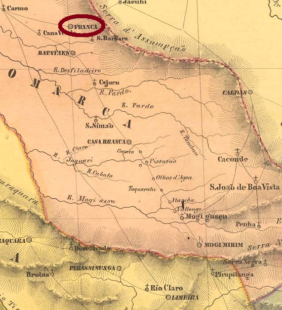
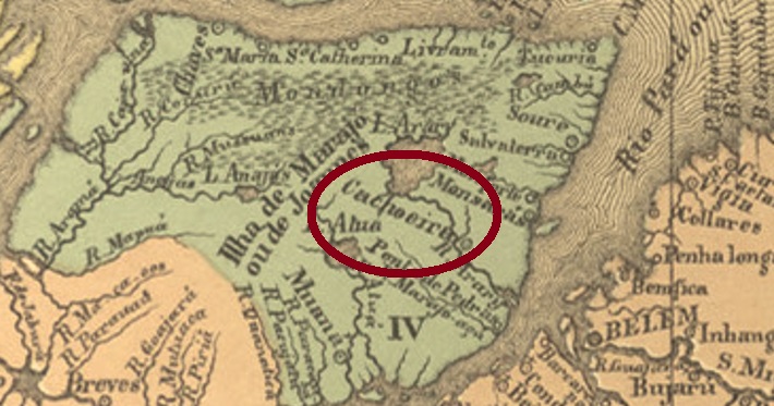
Other names: Arariuna, Cachoeira do Arari (1955)

See also Cachoeira/PA (R. Koester: Carimbologia VII)

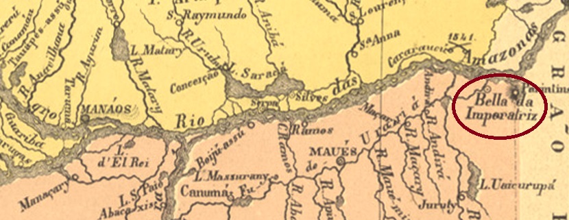
The Freguesia of Nossa Senhora da Conceição da Cachoeira was founded in 1747 on Marajó Island. It belonged to the Vila of Marajó and was located 70 km as the crow flies northwest of the future provincial capital of Belém do Pará. In May 1833, the village was elevated to villa status and in December 1930, it was demoted to a district in the Município of Arary. It returned as an independent município in October 1935, after which it changed its name twice: in December 1943 to Arariuna and in March 1955 to Cachoeira do Arari, which is still current today.

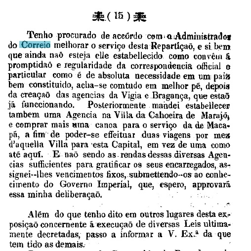
The local post office was opened and closed several times. The first opening took place around 1854, as can be seen from the provincial president’s report for May 1855:

Relatorio do Presidente da Provincia/PA, 05/1855

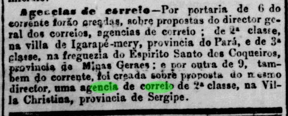
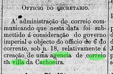
The agency was closed until 1858, as R. Koester (Carimbologia VII) reports a reopening in May 1859. However, no post office was in operation there in March 1867, as the regional press writes:

Jornal do Pará, 02.03.1867

The next opening took place around 1877 at the latest, as the provincial president’s report for February 1881 lists post office receipts from 1877 to 1880. Finally, the Directory of Imperial Post Offices (Tabella das Agencias do Correio do Imperio, Rio de Janeiro, 1885) lists this agency with year of creation 1882.

Until now, no imperial postmark from this locality has been seen.

Villiers de l’Ile Adam: Carta (…) das Provincias do Grão Pará e Alto Amazonas, 1850

Andere Namen: Arariuna, Cachoeira do Arari (1955)

Siehe auch Cachoeira/PA (R. Koester: Carimbologia VII)

Die Freguesia von Nossa Senhora da Conceição da Cachoeira entstand 1747 auf der Marajó-Insel. Sie gehörte der Vila von Marajó und lag 70 km Luftlinie nordwestlich der künftigen Provinzhauptstadt Belém do Pará entfernt. Im Mai 1833 wurde der Ort zur Villa erhoben und im Dezember 1930 zum Distrikt im Município von Arary degradiert. Der Wiederaufstieg als eigenständiger Município erfolgte im Oktober 1935. Danach wechselte der Ort seinen Namen zweimal: im Dezember 1943 zu Arariuna und im März 1955 zum heute noch aktuellen Cachoeira do Arari.

Das örtliche Postamt wurde mehrmals eröffnet und geschlossen. Die erste Eröffnung fand um 1854 statt, wie aus dem Bericht des Provinzpräsidenten für Mai 1855 zu entnehmen ist:

Relatorio do Presidente da Provincia/PA, 05/1855

Die Agentur wurde bis 1858 geschlossen, denn R. Koester (Carimbologia VII) berichtet über eine Neueröffnung im Mai 1859. Allerdings war dort kein Postamt in Betrieb im März 1867, wie die Regionalpresse schreibt:

Jornal do Pará, 02.03.1867

Die nächste Eröffnung fand spätestens um 1877 statt, da der Bericht des Provinzpräsidenten für Februar 1881 Postamtseinnahmen von 1877 bis 1880 auflistet. Schließlich listet das Verzeichnis der kaiserlichen Postämter (Tabella das Agencias do Correio do Imperio, Rio de Janeiro, 1885) diese Agentur mit Entstehungsjahr 1882 auf.

Bisher war kein kaiserlicher Poststempel aus dieser Ortschaft zu sehen.

Categories
Carimbologia T-Z

Villa da Barra, Bahia (VBA-0775)

Villiers de l’Ile Adam: Carta (…) da Provincia da Bahia, 1848

Other names: Villa da Barra do Rio Grande, Barra (1931)

See also Barra (R. Koester: Carimbologia III)

The Portuguese word Barra means, among others, a river mouth. This was the case in December 1752, when the freguesia of São Francisco das Chagas da Barra do Rio Grande do Sul was founded, almost 700 km west of the future provincial capital Salvador. One should remember firstly that the locality was still in Pernambuco at that time because the entire left bank of the São Francisco River up to the border with the Capitania of Minas Gerais still belonged to Pernambuco until the failed revolution in 1817. And secondly, Rio Grande do Sul here has nothing to do with the province of the same name in the extreme south of the country, but refers to the Rio Grande, which rises on the border with Goiás and flows into the São Francisco, precisely at its barra.

As early as August 1753, the town was elevated to the status of Vila, but it was not until June 1873 – 120 years later – that Barra do Rio Grande became a town, and since June 1931 it has simply been called Barra.

Two creation years for the local post office have also been identified here. First in May 1832, as Nova Monteiro writes in Administrações e Agencias Postaes do Brasil Imperio (Brasil Filatelico/RJ, 1934-5; Reprint SPP 1994-1999). The next creation took place in September 1858, according to Reinhold Koester in Carimbologia III. Probably the oldest postmark is VBA-0775a, which was already used on Bull’s-Eyes from 1843 and already described by Henrique B. Ferreira in Catálogo ilustrado dos carimbos sobre os olhos-de-boi (Porto Alegre, 2017):

VBA-0775a (HBF B9) 1843ff

For later postmarks under BARRA see Koester, Carimbologia III.

Atlas do Imperio do Brasil, 1868

Andere Namen: Villa da Barra do Rio Grande, Barra (1931)

Siehe auch Barra (R. Koester: Carimbologia III)

Das portugiesische Wort Barra bedeutet unter anderen eine Flussmündung. So in diesem Fall, als im Dezember 1752 die Freguesia von São Francisco das Chagas da Barra do Rio Grande do Sul gegründet wurde, fast 700 km westlich der künftigen Provinzhauptstadt Salvador entfernt. Wobei erstens lag der Ort damals noch in Pernambuco, denn das gesamte linke Ufer des Flusses São Francisco bis zur Grenze zur Capitania von Minas Gerais gehörte bis zur missglückten Revolution 1817 noch zu Pernambuco. Und zweitens hat hier Rio Grande do Sul nichts mit der gleichnamigen Provinz in äußersten Süden des Landes zu tun, sondern bezieht sich auf den Rio Grande, der an der Grenze zu Goiás entspringt und in den São Francisco hineinfließt, eben an seiner Barra.

Bereits im August 1753 wurde der Ort zur Vila erhoben, aber erst im Juni 1873 – also 120 Jahre später – wurde Barra do Rio Grande eine Stadt, die seit Juni 1931 lediglich Barra heißt.

Zwei Gründungsjahre fürs örtliche Postamt wurden auch hier ermittelt. Erstmals im Mai 1832, wie Nova Monteiro in Administrações e Agencias Postaes do Brasil Imperio (Brasil Filatelico/RJ, 1934-5; Reprint SPP 1994-1999) schreibt. Dann wieder im September 1858, laut Reinhold Koester in Carimbologia III. Der wohl älteste Poststempel ist VBA-0775a, der schon auf Ochsenaugen von 1843 verwendet wurde und bereits durch Henrique B. Ferreira in Catálogo ilustrado dos carimbos sobre os olhos-de-boi (Porto Alegre, 2017) vorgestellt wurde:

VBA-0775a (HBF B9) 1843ff

Für spätere Poststempel unter BARRA siehe Koester, Carimbologia III.

Categories
Carimbologia T-Z

Villa Christina, Sergipe (VSE-0180)

Atlas do Imperio do Brasil, 1868

Other names: Chapada, Cristina, Cristinápolis (1943)

The former settlement of São Francisco de Assis da Chapada was located, as the name suggests, on the hillside more than 100 km southwest of the provincial capital Aracaju. In October 1878, the ascent to the villa took place under the name Christina, probably in honour of the Empress Teresa Cristina. In December 1938, the place name was simplified to Cristina and five years later it was complicated to Cristinápolis.

According to the Rio press, there had been a post office there since October 1882:

Jornal do Commercio/RJ, 11.10.1882

The only postmark of this place so far bears a date from 1901, but it could be a remaining from the Empire: VSE-0180a (Coll. Fuad Ferreira Fo.) is a double circle with the inscription VILLA CHRISTINA above and an ornament in lozenge below formed by four small lozenges, with the date in the centre.

Arthur D. Ribeiro: Estado de Sergipe, 1924

Andere Namen: Chapada, Cristina, Cristinápolis (1943)

Die ehemalige Siedlung von São Francisco de Assis da Chapada lag, wie der Name schon sagt, am Berghang über 100 km südwestlich der Provinzhauptstadt Aracaju entfernt. Im Oktober 1878 erfolgte der Aufstieg zur Villa unter dem Namen Christina, wohl zu Ehren der Kaiserin Teresa Cristina. Im Dezember 1938 wurde der Ortsname zu Cristina vereinfacht und fünf Jahre später zu Cristinápolis verkompliziert.

Wie aus der Presse aus Rio zu entnehmen ist, gab es dort seit Oktober 1882 ein Postamt:

Jornal do Commercio/RJ, 11.10.1882

Der bisher einzige Poststempel dieses Orts trägt zwar ein Datum aus 1901, könnte aber noch vom Kaiserreich stammen: VSE-0180a (Samml. Fuad Ferreira Fo.) ist ein Doppelkreis mit der Inschrift VILLA CHRISTINA oben und einem Ornament in Raute unten, das aus vier kleinen Rauten gebildet wird, mit dem Datum in der Mitte.

Categories
Carimbologia T-Z

Villa Bella, Pernambuco (VPE-0680)

Atlas do Imperio do Brasil, 1868

Other name: Serra Talhada (1938)

Villa Bella was a district in the Municipio of Flores from April 1838, located on the north bank of the Pajeú River, over 400 km west of the provincial capital Recife. In May 1851 it became a vila and in July 1909 a town, which has been called Serra Talhada since December 1938.

Two dates of origin for the local post office were found, firstly in 1854, as shown in the postal report (Relatorio Postal) for 1887. The next creation year would be 1873, as stated in the Directory of Imperial Post Offices (Tabella das Agencias do Correio do Imperio, Rio de Janeiro, 1885). Two postmarks have also survived in the 19th century, but unfortunately not the very first one among them. The French type VPE-0680b (Coll. Roberto Assef Jr.) has the inscription VILLA-BELLA in a double circle at the top and the typical star between brackets at the bottom. The centre was free – as usual in Pernambuco, so that the date would be entered by hand, which happened rather rarely. This cancel was found on stamps issued from 1885 onwards. VPE-0680c (Coll. José A. Junges) could already be republican. The double circle now reads VILLA BELLA without hyphen above, (PERNAMBUCO) below. One copy was found, dated 1891 in the centre.

Carta Corographica da Provincia de Pernambuco, 1880

Anderer Name: Serra Talhada (1938)

Villa Bella war ab April 1838 ein Distrikt im Municipio von Flores, der am Nordufer des Flusses Pajeú lag, über 400 km westlich der Provinzhauptstadt Recife entfernt. Im Mai 1851 wurde daraus eine Vila und im Juli 1909 eine Stadt, die seit Dezember 1938 Serra Talhada heißt.

Zwei Entstehungsdaten fürs örtliche Postamt wurden gefunden. Erstmals 1854, wie aus dem Postbericht (Relatorio Postal) für 1887 hervorgeht. Dann 1873, wie im Verzeichnis der kaiserlichen Postämter (Tabella das Agencias do Correio do Imperio, Rio de Janeiro, 1885) zu lesen ist. Auch zwei Poststempel sind im 19. Jahrhundert überliefert, aber leider nicht der allererste darunter. Der französischer Typus VPE-0680b (Samml. Roberto Assef Jr.) hat oben im Doppelkreis die Inschrift VILLA-BELLA und unten den typischen Stern zwischen Klammern. Das Zentrum war frei – wie in Pernambuco üblich, damit das Datum per Hand eingetragen werden sollte, was eher selten geschah. Dieser Stempel wurde auf Marken gefunden, die ab 1885 ausgegeben wurden. VPE-0680c (Samml. José A. Junges) könnte bereits republikanisch sein. Im Doppelkreis liest man oben nun VILLA BELLA ohne Bindestrich, unten (PERNAMBUCO). Ein Exemplar vorhanden, datiert 1891 in der Mitte.

Categories
Carimbologia T-Z

Villa Bella de Morrinhos, Goiás (VGO-0290)

Atlas do Imperio do Brasil, 1868

Other names: N. Sa. do Carmo dos Morrinhos, Villa Bella do Parnahyba

See also Morrinhos (R. Koester: Carimbologia XXVII)

The parish of Villa Bella do Parnahyba was founded in July 1843 and was situated – despite the river in the name – barely 100 km north of the Parnahyba and 270 km south of the provincial capital Goyaz (today Goiás Velho). In July 1857, it was promoted as a vila, but just two years later came its demotion as a district in the Município of Pouso Alto. In July 1871, the resurgence took place as Villa Bella de N. Sra. do Carmo do Parnahyba, which became the town of Morrinhos in August 1882. The Morrinhos are three small mountains, yet much closer than the river.

The local post office was established in 1880, as shown in the Directory of Imperial Post Offices (Tabella das Agencias do Correio do Imperio, Rio de Janeiro, 1885). Two circular postmarks were found for the 19th century. VGO-0290a (Coll. Karlheinz Wittig) has the inscription V.B. DE MORRINHOS at the top and an ornament in lozenge at the bottom, with dates in the middle from 1886 to 1889. The successor VGO-0290b (Coll. FM) has the inscription MORRINHOS at the top and (GOYAZ) at the bottom. The specimens found so far have inner dates from the Republic: 1890-1902.

Carta da Republica dos Estados Unidos do Brazil, 1892

Andere Namen: N. Sa. do Carmo dos Morrinhos, Villa Bella do Parnahyba

Siehe auch Morrinhos (R. Koester: Carimbologia XXVII)

Die Pfarrei von Villa Bella do Parnahyba entstand im Juli 1843 und lag – obwohl der Fluss im Namen stand – knapp 100 km nördlich des Parnahyba und 270 km südlich der Provinzhauptstadt Goyaz (heute Goiás Velho) entfernt. Im Juli 1857 erfolgte der Aufstieg als Vila, aber gleich zwei Jahre später kam die Degradierung als Distrikt im Município von Pouso Alto. Im Juli 1871 fand der Wiederaufstieg als Villa Bella de N. Sra. do Carmo do Parnahyba, die im August 1882 zur Stadt Morrinhos wurde. Die Morrinhos sind drei kleine Berge, die doch wesentlich näher als der Fluss liegen.

Das örtliche Postamt wurde 1880 ins Leben gerufen, wie aus dem Verzeichnis der kaiserlichen Postämter (Tabella das Agencias do Correio do Imperio, Rio de Janeiro, 1885) hervorgeht. Zwei Poststempel in Kreisform wurden fürs 19. Jahrhundert gefunden. VGO-0290a (Samml. Karlheinz Wittig) hat oben die Inschrift V.B. DE MORRINHOS und unten ein Ornament in Raute, mit Daten in der Mitte von 1886 bis 1889. Der Nachfolger VGO-0290b (Samml. FM) trägt oben die Inschrift MORRINHOS und unten (GOYAZ). Die bisher gefundenen Exemplare haben innere Daten aus der Republik: 1890-1902.

Categories
Carimbologia T-Z

Villa Bella (da Princesa), São Paulo (VSP-1480)

Atlas do Imperio do Brasil, 1868

Other names: Formosa, Ilhabela (1944)

The paradisiacal beauty of this seaside locality resonated in its place names. However, it was originally called Freguesia de N. Sra. da Ajuda e Bom Successo, and was located near the Vila of São Sebastião, 200 km east of the future provincial capital of São Paulo. In September 1805, it was promoted to Villa Bella da Princesa, which has been a city since April 1901. After that, the name of the Município changed twice: in November 1938 to Formosa and six years later to Ilhabela, which is still current today.

The local post office came into being in March 1865, as Nova Monteiro writes in Administrações e Agencias Postaes do Brasil Imperio (Brasil Filatelico/RJ, 1934-5; Reprint SPP 1994-1999) and is confirmed by the Rio press:

Correio Mercantil/RJ, 02.04.1865

A 19th century postmark was found, unfortunately not the first. The French type VSP-1480b (Coll. Mario Celso Orsi Jr.) has the inscription VILLA BELLA at the top and the typical star between brackets at the bottom. The previous dates in the middle are already set in the Republic: 1892-1893.

Villiers de l’Ile Adam: Carta (…) da Provincia de São Paulo, 1847

Andere Namen: Formosa, Ilhabela (1944)

Die paradiesische Schönheit dieser Ortschaft am Meer klang mehrmals in ihren Ortsnamen nach. Allerdings hieß sie ursprünglich Freguesia de N. Sra. da Ajuda e Bom Successo, und lag bei Vila von São Sebastião, 200 km östlich der künftigen Provinzhauptstadt São Paulo entfernt. Im September 1805 erfolgte der Aufstieg zur Villa Bella da Princesa, die seit April 1901 eine Stadt ist. Danach wechselte der Name des Município zweimal: im November 1938 zu Formosa und sechs Jahre später zum heute noch aktuellen Ilhabela.

Das örtliche Postamt entstand im März 1865, wie Nova Monteiro in Administrações e Agencias Postaes do Brasil Imperio (Brasil Filatelico/RJ, 1934-5; Reprint SPP 1994-1999) schreibt und durch die Presse aus Rio bestätigt wird:

Correio Mercantil/RJ, 02.04.1865

Ein Poststempel für den 19. Jahrhundert wurde gefunden, leider nicht der erste. Der französischer Typus VSP-1480b (Samml. Mario Celso Orsi Jr.) hat oben die Inschrift VILLA BELLA und unten den typischen Stern zwischen Klammern. Die bisherigen Daten in der Mitte sind bereits in der Republik angesiedelt: 1892-1893.

Categories
Carimbologia T-Z

Villa Bella (da Imperatriz), Pará/Amazonas (VAM-0105) – Villa Nova (da Rainha), Pará (VPA-0248)

Atlas do Imperio do Brasil, 1868

Other names: Tupinambarana, Parintins (1880)

See also Parintins (R. Koester: Carimbologia XXX)

The former Indian settlement of the Tupinambaranas occupied the island of the same name on the south bank of the Amazon, 370 km east of the future provincial capital Manaus. In 1804, the missionary colony of Villa Nova da Rainha was founded there, which belonged to the Vila of Maués in the Capitania of Grão-Pará. In October 1848, it was officially promoted to Vila, and four years later the place – now under the imperial name of Villa Bella da Imperatriz – changed to the province of Amazonas. Finally, in October 1880, it became a town, still called Parintins today.

Three periods of operation of the local post office have been identified, including twice when the town was still in the province of Pará. The very first establishment is still unknown, but must have taken place before 1845, as can be seen from the regional press. The second post office foundation took place in November 1847, as Nova Monteiro writes in Administrações e Agencias Postaes do Brasil Imperio (Brasil Filatelico/RJ, 1934-5; Reprint SPP 1994-1999). The agency last opened in 1859, as listed in the Directory of Imperial Post Offices (Tabella das Agencias do Correio do Imperio, Rio de Janeiro, 1885).

Unfortunately, no imperial-era postmark has been found here either so far.

Villiers de l’Ile Adam: Carta (…) das Provincias do Grão-Pará e Alto Amazonas, 1850

Andere Namen: Tupinambarana, Parintins (1880)

Siehe auch Parintins (R. Koester: Carimbologia XXX)

Die ehemalige Indianersiedlung des Stamms der Tupinambaranas belegte die gleichnamige Insel am Südufer des Amazonas, die 370 km östlich der künftigen Provinzhauptstadt Manaus entfernt lag. 1804 wurde dort die Missionskolonie Villa Nova da Rainha gegründet, die zur Vila von Maués in der Capitania von Grão-Pará gehörte. Im Oktober 1848 erfolgte der offizielle Aufstieg zur Vila, und vier Jahre später wechselte der Ort – nun unter dem kaiserlichen Namen Villa Bella da Imperatriz – zur Provinz Amazonas. Im Oktober 1880 schließlich wurde daraus eine Stadt, die noch heute Parintins heißt.

Drei Betriebsperioden des örtlichen Postamts wurden ermittelt, davon zweimal als der Ort noch in der Provinz Pará lag. Die allererste Entstehung ist noch unbekannt, musste aber vor 1845 stattgefunden haben, wie aus der Regionalpresse zu entnehmen ist. Die zweite Postamtsgründung fand im November 1847 statt, wie Nova Monteiro in Administrações e Agencias Postaes do Brasil Imperio (Brasil Filatelico/RJ, 1934-5; Reprint SPP 1994-1999) schreibt. Zuletzt eröffnete die Agentur 1859, wie im Verzeichnis der kaiserlichen Postämter (Tabella das Agencias do Correio do Imperio, Rio de Janeiro, 1885) aufgelistet.

Auch hier konnte bisher leider kein Poststempel der Kaiserzeit gefunden werden.

Categories
Carimbologia T-Z

Villa (Nova) do Principe, Rio Grande do Norte (VRN-0140)

Atlas do Imperio do Brasil, 1868

Other names: Seridó, Caicó (1890)

See also Principe/RN (R. Koester: Carimbologia XXXII)

The former freguesia of Príncipe already existed in the 18th century and was situated on the south bank of the river Seridó, 280 km west of the future provincial capital Natal. However, the freguesia still belonged to the Vila of Piancó, which in turn was in Parahyba. Only when it was promoted as Vila Nova do Principe in July 1788 did it change to the Capitania of Rio Grande do Norte. This was followed by its designation as a town in December 1868. After the end of the Empire, the town’s name changed twice in 1890: in February to Seridó and in July to Caicó, which is still current today.

Two creation years were found for the local post office. First in April 1818, as both Nova Monteiro in Administrações e Agencias Postaes do Brasil Imperio (Brasil Filatelico/RJ, 1934-5; Reprint SPP 1994-1999) and the Directory of Imperial Post Offices (Tabella das Agencias do Correio do Imperio, Rio de Janeiro, 1885) record. Then again in 1863, as Reinhold Koester writes in Carimbologia XXXII. So far, no imperial postmark could be assigned with certainty to this locality.

Villiers de l’Ile Adam: Carta (…) das Provincias do Rio Grande do Norte e Parahiba, 1848

Andere Namen: Seridó, Caicó (1890)

Siehe auch Principe/RN (R. Koester: Carimbologia XXXII)

Die ehemalige Freguesia von Príncipe gab es schon im 18. Jahrhundert und lag am Südufer des Flusses Seridó, 280 km westlich der künftigen Provinzhauptstadt Natal. Allerdings gehörte der Freguesia noch zur Vila von Piancó, die wiederum in Parahyba war. Erst bei dem Aufstieg als Vila Nova do Principe im Juli 1788 wechselte der Ort zur Capitania von Rio Grande do Norte. Im Dezember 1868 folgte die Ernennung zur Stadt. Nach dem Ende des Kaiserreichs wechselte der Ortsname 1890 gleich zweimal: Im Februar zu Seridó und im Juli zum heute noch aktuellen Caicó. Zwei Gründungsjahre wurden fürs örtliche Postamt gefunden. Erstmals im April 1818, wie sowohl Nova Monteiro in Administrações e Agencias Postaes do Brasil Imperio (Brasil Filatelico/RJ, 1934-5; Reprint SPP 1994-1999) als auch das Verzeichnis der kaiserlichen Postämter (Tabella das Agencias do Correio do Imperio, Rio de Janeiro, 1885) registrieren. Dann nochmals 1863, wie Reinhold Koester in Carimbologia XXXII schreibt. Bisher konnte kein kaiserlicher Poststempel mit Sicherheit dieser Ortschaft zugeordnet werden.

Categories
Carimbologia T-Z

Vila Rica, Minas Gerais (VMG-3750)

Jean-Baptiste Debret: Carte du Brésil, 1834

Other names: Arraial das Minas Geraes, Vila Rica de N. Sra do Ouro Preto, Ouro Preto (1823)

See also Ouro Preto (R. Koester: Carimbologia XXIX)

This locality was the capital of the Capitania, Province and State of Minas Gerais from 1720 to 1897, so its successor capital Belo Horizonte will have to wait until 2074 to break this record. The story began in the late 17th century with the founding of Arraial das Minas Geraes de Ouro Preto on the north bank of the Rio do Carmo, 400 km north of the colonial capital Rio de Janeiro. In July 1711, it was named Villa Rica de N. Sra. do Ouro Preto (or also de Albuquerque), which was then elevated to Imperial Cidade in March 1823.

As Paula Sobrinho writes in História Postal de Minas Gerais (Belo Horizonte, 1997), there was a post office there since March 1798. The earliest postmark is VMG-3750a, used until at least 1823 and already known through the RHM catalogue as P-MG-68:

VMG-3750a (RHM P-MG-68)

Later postmarks already bear the place name Ouro Preto and were already presented by R. Koester in Carimbologia XXIX.

Province of Minas Geraes, 1835

Andere Namen: Arraial das Minas Geraes, Vila Rica de N. Sra do Ouro Preto, Ouro Preto (1823)

Siehe auch Ouro Preto (R. Koester: Carimbologia XXIX)

Diese Ortschaft war die Hauptstadt der Capitania, Provinz und Staat Minas Gerais von 1720 bis 1897. Also muss die Nachfolgehauptstadt Belo Horizonte bis 2074 warten, um diesen Rekord zu brechen. Die Geschichte begann im späten 17. Jahrhundert mit der Gründung des Arraial das Minas Geraes de Ouro Preto am Nordufer des Rio do Carmo, 400 km nördlich der Kolonialhauptstadt Rio de Janeiro entfernt. Im Juli 1711 erfolgte die Ernennung zu Villa Rica de N. Sra. do Ouro Preto (oder auch de Albuquerque), die dann im März 1823 zur Kaiserlichen Stadt (Imperial Cidade) erhoben wurde.

Wie Paula Sobrinho in História Postal de Minas Gerais (Belo Horizonte, 1997) schreibt, gab es dort ein Postamt seit März 1798. Der früheste Poststempel ist VMG-3750a, der bis mindestens 1823 verwendet und bereits durch den RHM-Katalog unter P-MG-68 bekannt wurde:

VMG-3750a (RHM P-MG-68)

Spätere Poststempel tragen bereits die Ortsbezeichnung Ouro Preto und wurden bereits durch R. Koester in Carimbologia XXIX vorgestellt.

Categories
Carimbologia T-Z

Vila Franca, São Paulo (VSP-1755)

Atlas do Imperio do Brasil, 1868

Other names: Capim Mimoso, Villa Franca d’El-Rei, Villa Franca do Imperador, Franca

The settlement of Capim Mimoso (Tender Lawn) was already a freguesia near Mogy-Merim in the early 19th century, 400 km north of the later provincial capital of São Paulo. It was elevated to Vila Franca d’El-Rei in October 1821, but this homage to the Portuguese king lapsed after Brazil’s independence in September 1822. So the name was changed to Vila Franca do Imperador in October 1823. Since April 1856, the town has been known simply as Franca and is Brazil’s leading producer of men’s shoes.

Two creation dates were found for the local post office. First in February 1832, as Nova Monteiro writes in Administrações e Agencias Postaes do Brasil Imperio (Brasil Filatelico/RJ, 1934-5; Reprint SPP 1994-1999). Then again in 1846, as listed in the Directory of Imperial Post Offices (Tabella das Agencias do Correio do Imperio, Rio de Janeiro, 1885). The earliest postmark is probably VSP-1755a, which also occurs in sepia, was in circulation from 1833 to at least 1843, and was already presented in the RHM catalogue under P-SP-11:

VSP-1755a (RHM P-SP-11)

It was followed by VSP-1755b, which was used from about 1843 to 1864, also in red. Paulo Ayres has already shown it in Catálogo de Carimbos Brasil-Império (S. Paulo, 1937, 1942) under no. 1526:

VSP-1755b (P.A. 1526)

Later postmarks bear the place name FRANCA and were already presented by Reinhold Koester in Carimbologia XIX.

Villiers de l’Ile Adam: Carta (…) da Provincia de São Paulo, 1847

Andere Namen: Capim Mimoso, Villa Franca d’El-Rei, Villa Franca do Imperador, Franca

Die Siedlung Capim Mimoso (Zarter Rasen) war bereits im frühen 19. Jahrhundert eine Freguesia bei Mogy-Merim, die 400 km nördlich der späteren Provinzhauptstadt São Paulo lag. Sie wurde im Oktober 1821 zur Vila Franca d’El-Rei erhoben, aber diese Hommage an den portugiesischen König war nach der Unabhängigkeit Brasiliens im September 1822 hinfällig. So wurde der Name im Oktober 1823 zu Vila Franca do Imperador geändert. Der Ort ist seit April 1856 eine Stadt, die heute einfach Franca heißt und Brasiliens führender Erzeuger von Männerschuhen ist.

Zwei Gründungsdaten wurden fürs örtliche Postamt gefunden. Erstmals im Februar 1832, wie Nova Monteiro in Administrações e Agencias Postaes do Brasil Imperio (Brasil Filatelico/RJ, 1934-5; Reprint SPP 1994-1999) schreibt. Dann wieder 1846, wie im Verzeichnis der kaiserlichen Postämter (Tabella das Agencias do Correio do Imperio, Rio de Janeiro, 1885) aufgelistet. Der früheste Poststempel ist wohl VSP-1755a, der auch in Sepia vorkommt, von 1833 bis mindestens 1843 im Umlauf war und bereits im RHM-Katalog unter P-SP-11 vorgestellt wurde:

VSP-1755a (RHM P-SP-11)

Ihm folgte VSP-1755b, der ab ca. 1843 bis 1864, auch in Rot, angewendet wurde. Paulo Ayres hat ihn bereits in Catálogo de Carimbos Brasil-Império (S. Paulo, 1937, 1942) unter Nr. 1526 gezeigt:

VSP-1755b (P.A. 1526)

Spätere Poststempel tragen die Ortsbezeichnung FRANCA und wurden bereits durch Reinhold Koester in Carimbologia XIX vorgestellt.