Categories
Carimbologia T-Z

Vigia, Pará (VPA-0245)

Villiers de l’Ile Adam: Carta (…) das Provincias do Grão Pará e Alto Amazonas, 1850

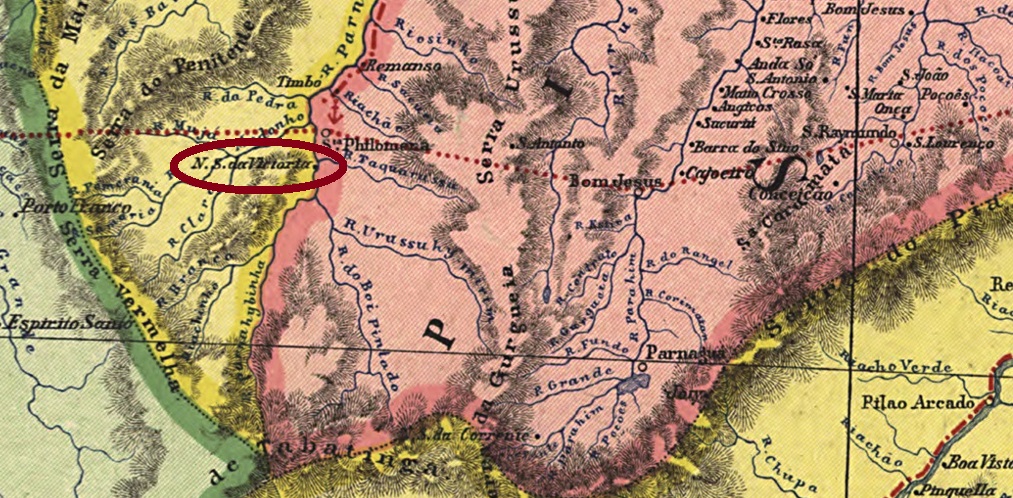
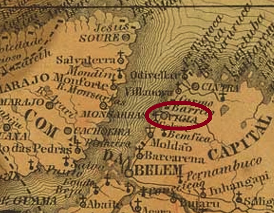
Another name: Uruitá

The Portuguese word Vigia means guard. So, the strategically located Indian settlement of Uruitá became a guard post of the colonial power to put a stop to robbers and smugglers. As early as 1693, the freguesia of N. Sra. de Nazareth da Vigia was established on the east bank of the Furo da Laura (Laura’s Waterway), 100 km north of the future provincial capital Belém do Pará. Five years later, the place was already a vila, which was elevated to a town in October 1854.

Two dates of origin for the local post office were found. The first one was around 1855, as can be read in the provincial president’s report for May of that year:

Relatorio do Presidente da Provincia/PA, May 1855

Then again in July 1858, as Nova Monteiro writes in Administrações e Agencias Postaes do Brasil Imperio (Brasil Filatelico/RJ, 1934-5; Reprint SPP 1994-1999). Only one imperial postmark has been found so far, unfortunately not the oldest. The French type VPA-0245b (Coll. Karlheinz Wittig) shows the inscription VIGIA in a double circle at the top and the typical star between brackets at the bottom. Dates in the middle were found for 1886-1888.

Atlas do Imperio do Brasil, 1868

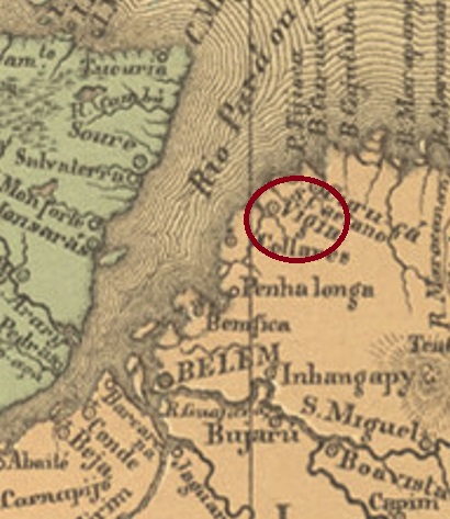
Anderer Name: Uruitá

Das portugiesische Wort Vigia bedeutet Wache. Also wurde aus der strategisch gelegenen Indianersiedlung Uruitá ein Wachposten der Kolonialmacht, um Wegelagerern und Schmugglern das Handwerk zu legen. Bereits 1693 entstand die Freguesia von N. Sra. de Nazareth da Vigia am Ostufer des Furo da Laura (Lauras Wasserweg), 100 km nördlich der künftigen Provinzhauptstadt Belém do Pará entfernt. Fünf Jahre später war der Ort bereits eine Vila, die im Oktober 1854 zur Stadt erhoben wurde.

Zwei Entstehungsdaten fürs örtliche Postamt wurden gefunden. Erstmals ca. 1855, wie aus dem Bericht des Provinzpräsidenten für Mai d. Js. zu entnehmen ist:

Relatorio do Presidente da Provincia/PA, Mai 1855

Dann wieder im Juli 1858, wie Nova Monteiro in Administrações e Agencias Postaes do Brasil Imperio (Brasil Filatelico/RJ, 1934-5; Reprint SPP 1994-1999) schreibt. Nur ein kaiserlicher Poststempel wurde bisher gefunden, leider nicht der älteste. Der französische Typus VPA-0245b (Samml. Karlheinz Wittig) zeigt oben im Doppelkreis die Inschrift VIGIA, unten ist der typische Stern zwischen Klammern zu sehen. Bisherige Daten in der Mitte: 1886-1888.

Categories
Carimbologia T-Z

Vieira Braga (train station/Bahnhof), Rio de Janeiro (VRJ-1928)

Almanak Laemmert, 1892

Vieira Braga station was inaugurated in 1883 by the E.F. Santo Antonio de Padua railway company and located in the município of São Fidélis, 260 km northeast of the capital Rio de Janeiro. Afterwards, the railway line changed ownership three times: in 1884 to E.F. Macahe e Campos, in 1887 to E.F. Leopoldina and from 1975 until its closure in 1996, it belonged to Rede Ferroviária Federal S.A. (estacoesferroviarias.com.br). As for who gave the station its name, it was probably Miguel da Silva Vieira Braga, a Rio doctor who died in 1882 and was, among others, a director of both the E.F. Sto. Antonio de Padua and the E.F. Macahe e Campos.

The station area changed to the município of Monte Verde in May 1891 and has belonged to the município of Cambuci since October 1918. Today the station building has disappeared, only the tracks and platform remain:

2006 (Photo: Carlos Latuff in estacoesferroviarias.com.br)

As can be read in the postal report (Relatorio Postal) for 1887, there was a station post office since December 1887, which is confirmed by the Rio press:

Diario de Noticias, 03.01.1888

The station postmark in the Empire is VRJ-1928a (Coll. José A. Junges): a double circle with the inscription EST. VIEIRA BRAGA above and an ornament in X below. The dates in the middle were found for the period 1889-1890.

Estrada de Ferro Leopoldina

Der Bahnhof Vieira Braga wurde 1883 durch die E.F. Santo Antonio de Padua Bahngesellschaft eingeweiht und lag im Município von São Fidélis, 260 km nordöstlich der Hauptstadt Rio de Janeiro entfernt. Danach wechselte die Bahnlinie den Besitz dreimal: 1884 zur E.F. Macahe e Campos, 1887 zur E.F. Leopoldina und von 1975 bis zur Stilllegung 1996 gehörte sie der Rede Ferroviária Federal S.A. (estacoesferroviarias.com.br). Was den Namensgeber des Bahnhofs betrifft, vermutlich handelte es sich um Miguel da Silva Vieira Braga, einen 1882 verstorbenen Arzt aus Rio, der u.a. Vorstand der E.F. Sto. Antonio de Padua und der E.F. Macahe e Camposwar.

Das Bahnhofareal wechselte im Mai 1891 zum Município von Monte Verde und gehört seit Oktober 1918 zu Município von Cambuci. Heute ist das Bahnhofsgebäude verschwunden, nur die Gleise und Plattform sind übriggeblieben:

2006 (Foto: Carlos Latuff in estacoesferroviarias.com.br)

Wie im Postbericht (Relatorio Postal) für 1887 zu lesen ist, gab es ein Bahnhofspostamt seit Dezember 1887, was durch die Rio-Presse bestätigt wird:

Diario de Noticias, 03.01.1888

Der Bahnhofspoststempel im Kaiserreich ist VRJ-1928a (Samml. José A. Junges): ein Doppelkreis mit der Inschrift EST. VIEIRA BRAGA oben und einem Ornament in X unten. Die Daten in der Mitte wurden für den Zeitraum 1889-1890 gefunden.

Categories
Carimbologia T-Z

Victoria, Pernambuco (VPE-0675)

Atlas do Imperio do Brasil, 1868

Text updated on September 8, 2022

Other names: Victoria de Santo Antão, Santo Antão

This village was from March 1873 on a freguesia of the Vila of Olinda, located 50 km west of the future provincial capital Recife. It was promoted to vila in November 1811, and to town in May 1843. Since December 1943, the Município has been called Vitória de Santo Antão.

Two dates of origin for the local post office were found. First in March 1829, as Nova Monteiro writes in Administrações e Agencias Postaes do Brasil Imperio (Brasil Filatelico/RJ, 1934-5; Reprint SPP 1994-1999). Then again in 1834, as can be read in both the Directory of Imperial Post Offices (Tabella das Agencias do Correio do Imperio, Rio de Janeiro, 1885) and the Postal Report (Relatorio Postal) for 1887.

In the first text for this locality, I claimed that the postmark P. Ayres 1183 belonged here. New research by Paulo Novaes on the origin of the Victoria post office in the province of Espírito Santo has disproved my assumption: said postmark most probably comes from Victoria there. Here is the link:

http://agenciaspostais.com.br/?page_id=7571

So we have only found the French type VPE-0675b (Coll. Fuad Ferreira Fo.) for Victoria in Pernambuco: in this double circle one reads VICTORIA above, below is the typical star between brackets, and the date (so far found between ca.1882 and 1888) should be written by hand.

Villiers de l’Ile Adam: Carta (…) das Provincias de Pernambuco, Alagoas e Sergipe, 1848

Textaktualisierung am 8. September 2022

Andere Namen: Victoria de Santo Antão, Santo Antão

Diese Ortschaft war ab März 1873 eine Freguesia der Vila von Olinda, die 50 km westlich der künftigen Provinzhauptstadt Recife entfernt lag. Im November 1811 erfolgte der Aufstieg zur Vila, und im Mai 1843 zur Stadt. Seit Dezember 1943 heißt der Município Vitória de Santo Antão.

Zwei Entstehungsdaten fürs örtliche Postamt waren zu finden. Erstmals im März 1829, wie Nova Monteiro in Administrações e Agencias Postaes do Brasil Imperio (Brasil Filatelico/RJ, 1934-5; Reprint SPP 1994-1999) schreibt. Dann wieder 1834, wie sowohl im Verzeichnis der kaiserlichen Postämter (Tabella das Agencias do Correio do Imperio, Rio de Janeiro, 1885) als auch im Postbericht (Relatorio Postal) für 1887 zu lesen ist.

Im ersten Text für diese Ortschaft habe ich behauptet, dass der Poststempel P. Ayres 1183 hierher gehört. Neue Recherchen von Paulo Novaes über die Entstehung des Postamtes Victoria in der Provinz Espírito Santo konnten meine Vermutung widerlegen: besagter Poststempel kommt höchstwahrscheinlich vom dortigen Victoria. Hier der Link:

http://agenciaspostais.com.br/?page_id=7571

Somit haben wir nur den französischen Typus VPE-0675b (Samml. Fuad Ferreira Fo.) für Victoria in Pernambuco gefunden: in diesem Doppelkreis liest man VICTORIA oben, unten ist der typische Stern zwischen Klammern, und das Datum (bisher zwischen ca.1882 und 1888 gefunden) sollte per Hand eingetragen werden.

Categories
Carimbologia T-Z

Victoria (train station/Bahnhof), São Paulo (VSP-1470)

Cia. Paulista

Another name: Est. Vitoriana (1945)

Victoria station was inaugurated in June 1888 by the E.F. Sorocabana, Main Line, located in the Município of Botucatu, 250 km northwest of the provincial capital São Paulo. The railway line changed hands three times: in 1892 to the Cia. União Sorocabana e Ytuana, in 1907 to the Sorocabana Railway, and from 1919 until its closure in 1954 it belonged to the E. F. Sorocabana (estacoesferroviarias.com.br). Around the station, the settlement continued to grow and became the district of Victoria in December 1928. This was renamed Vitoriana in November 1944, and a year later the station was called the same.

The station post office was created in October 1888, according to the regional press:

A Provincia de S. Paulo, 24.10.1888

The imperial postmark is VSP-1470 (Coll. José A. Junges): a double circle with the inscription EST. DA VICTORIA at the top. The only copy is dated 1889 in the centre.

Ayres de Camargo, in estacoesferroviarias.com.br

Anderer Name: Est. Vitoriana (1945)

Der Bahnhof Victoria wurde im Juni 1888 durch die E.F. Sorocabana, Hauptlinie, eingeweiht und lag im Município von Botucatu, 250 km nordwestlich der Provinzhauptstadt São Paulo entfernt. Die Bahnhlinie wechselte dreimal: 1892 zur Cia. União Sorocabana e Ytuana, 1907 zur Sorocabana Railway, und von 1919 bis zur Stilllegung 1954 gehörte sie der E. F. Sorocabana (estacoesferroviarias.com.br). Rund um den Bahnhof wuchs die Siedlung weiter und wurde im Dezember 1928 zum Distrikt von Victoria. Dieser wurde im November 1944 zu Vitoriana umbenannt, und ein Jahr später hieß der Bahnhof auch so.

Das Bahnhofspostamt wurde im Oktober 1888 ins Leben gerufen, wie aus der Regionalpresse hervorgeht:

A Provincia de S. Paulo, 24.10.1888

Der kaiserliche Poststempel ist VSP-1470 (Samml. José A. Junges): ein Doppelkreis mit der Inschrift EST. DA VICTORIA oben. Das einzige Exemplar ist mit 1889 in der Mitte datiert.

Categories
Carimbologia T-Z

Victoria, Bahia (VBA-0835)

Villiers de l’Ile Adam: Carta (…) da Provincia da Bahia, 1848

Other names: Conquista, Vitória da Conquista (1943)

See also Imperial Villa de Victoria (R. Koester: Carimbologia XXII)

The chapel of N. Sra. da Victoria da Conquista was built in 1783 near Caetité, more than 500 km southwest of the future provincial capital Salvador da Bahia. It became a vila in May 1840, was named a town in July 1891, and has been called the Município of Vitória da Conquista since December 1943.

Two years of origin for the local post office were found. First in January 1843, as Nova Monteiro writes in Administrações e Agencias Postaes do Brasil Imperio (in Brasil Filatelico/RJ, 1934-5; Reprint SPP 1994-1999). Then again in 1866, as listed in the Directory of Imperial Post Offices (Tabella das Agencias do Correio do Imperio, Rio de Janeiro, 1885). The imperial postmark VBA-0835a was already presented by Paulo Ayres in Catálogo de Carimbos Brasil-Império (S. Paulo, 1937, 1942) under no. 1603:

VBA-0835a (P.A. 1603) 1843-1888ff
Atlas do Imperio do Brasil, 1868

Andere Namen: Conquista, Vitória da Conquista (1943)

Siehe auch Imperial Villa de Victoria (R. Koester: Carimbologia XXII)

Die Kapelle von N. Sra. da Victoria da Conquista wurde 1783 bei Caetité errichtet und lag über 500 km südwestlich der künftigen Provinzhauptstadt Salvador da Bahia entfernt. Der Aufsiteg zur Vila erfolgte im Mai 1840. Im Juli 1891 fand die Ernennung zu einer Stadt statt, die Conquista hieß, und seit Dezember 1943 nennt sich dieser Município Vitória da Conquista.

Zwei Entstehungsjahre fürs örtliche Postamt waren zu finden. Erstmals im Januar 1843, wie Nova Monteiro in Administrações e Agencias Postaes do Brasil Imperio (in Brasil Filatelico/RJ, 1934-5; Reprint SPP 1994-1999) schreibt. Dann wieder 1866, wie im Verzeichnis der kaiserlichen Postämter (Tabella das Agencias do Correio do Imperio, Rio de Janeiro, 1885) aufgelistet. Der kaiserliche Poststempel VBA-0835a wurde bereits durch Paulo Ayres in Catálogo de Carimbos Brasil-Império (S. Paulo, 1937, 1942) unter Nr. 1603 vorgestellt:

VBA-0835a (P.A. 1603) 1843-1888ff

Categories
Carimbologia T-Z

Victoria (Alto Parnahyba), Maranhão (VMA-0290)

Carta da Republica dos Estados Unidos do Brazil, 1892

Other names: Parnahyba, Alto Parnaiba (1943)

This locality was, from June 1871, a district called N. Sra. da Victoria do Alto Parnahyba, located near Loreto on the west bank of the river Parnaíba, more than 1000 km south of the provincial capital São Luís. In April 1881, it became a vila, and this município has been called Alto Parnaíba since December 1943.

Two dates of origin for the local post office have been found. First in June 1860, as Nova Monteiro writes in Administrações e Agencias Postaes do Brasil Imperio (in Brasil Filatelico/RJ, 1934-5; Reprint SPP 1994-1999). Then again in December 1882, as shown in the postal report (Relatório Postal) for 1887. So far, no imperial postmark could be assigned with certainty to this locality.

Google Maps

Andere Namen: Parnahyba, Alto Parnaiba (1943)

Diese Ortschaft war ab Juni 1871 ein Distrikt namens N. Sra. da Victoria do Alto Parnahyba, der bei Loreto am Westufer des Flusses Parnaíba lag, über 1000 km südlich der Provinzhauptstadt São Luís entfernt. Im April 1881 erfolgte der Aufstieg zur Vila, und dieser Município heißt seit Dezember 1943 Alto Parnaíba.

Zwei Entstehungsdaten fürs örtliche Postamt wurden gefunden. Erstmals im Juni 1860, wie Nova Monteiro in Administrações e Agencias Postaes do Brasil Imperio (in Brasil Filatelico/RJ, 1934-5; Reprint SPP 1994-1999) schreibt. Dann wieder im Dezember 1882, wie aus dem Postbericht (Relatório Postal) für 1887 hervorgeht. Bisher konnte kein kaiserlicher Poststempel mit Sicherheit dieser Ortschaft zugeordnet werden.

Categories
Carimbologia T-Z

Viçosa, Minas Gerais (VMG-3300)

Estado de Minas Geraes, 1910

Other names: Santa Rita do Turvo, Viçosa

See also Santa Rita do Turvo (SMG-2895)

The Freguesia of Santa Rita do Turvo was founded in July 1832 in the Município of Ubá and was located on the south bank of the river Turvo Sujo (=Dirty Turbid), 115 km southeast of the provincial capital Ouro Preto. In September 1871, it was officially promoted to a vila, which was then declared Cidade Viçosa de Santa Rita in June 1876. This name was shortened to Viçosa in August 1911. 

As Paula Sobrinho wrote in História Postal de Minas Gerais (Belo Horizonte, 1997), there had been a post office there since February 1873, when the place was still called Santa Rita do Turvo. So far, however, no postmark with this place name has been found. The first cancelled stamp with Viçosa is VMG-3300a, which was probably in circulation from 1873 and was already shown by Paulo Ayres in Catálogo de Carimbos Brasil-Império (S. Paulo, 1937, 1942) under No. 1536:

VMG-3300a (P.A. 1536), 1873-1877ff

It was followed by VMG-3300b (Coll. José A. Junges): a double circle with the inscriptions VIÇOSA above and (MINAS) below. The dates in the middle have so far been found for the period 1885-1889.

Estado de Minas Geraes, 1911

Andere Namen: Santa Rita do Turvo, Viçosa

Siehe auch Santa Rita do Turvo (SMG-2895)

Die Freguesia von Santa Rita do Turvo wurde im Juli 1832 im Município von Ubá gegründet und lag am Südufer des Flusses Turvo Sujo (=Schmutzig-Trüb), 115 km südöstlich der Provinzhauptstadt Ouro Preto entfernt. Im September 1871 fand der offizielle Aufstieg zur Vila statt, die dann im Juni 1876 zur Cidade Viçosa de Santa Rita erklärt wurde. Dieser Name wurde im August 1911 zu Viçosa verkürzt. 

Wie Paula Sobrinho in História Postal de Minas Gerais (Belo Horizonte, 1997) schrieb, gab es dort ein Postamt seit Februar 1873, also noch zu der Zeit, als der Ort Santa Rita do Turvo hieß. Bisher wurde aber kein Poststempel mit diesem Ortsnamen gefunden. Der erste Stempel mit Viçosa ist VMG-3300a, der wohl ab 1873 im Umlauf war und bereits durch Paulo Ayres in Catálogo de Carimbos Brasil-Império (S. Paulo, 1937, 1942) unter der Nr. 1536 gezeigt wurde wurde:

VMG-3300a (P.A. 1536), 1873-1877ff

Ihm folgte VMG-3300b (Samml. José A. Junges): ein Doppelkreis mit den Inschriften VIÇOSA oben und (MINAS) unten. Die Daten in der Mitte wurden bisher für den Zeitraum 1885-1889 gefunden.

Categories
Carimbologia T-Z

Vicencia, Pernambuco (VPE-0670)

Carta Corographica da Provincia de Pernambuco, 1880

The Freguesia of Sant’Anna da Vicencia was founded in June 1879 near Nazareth, located on the south bank of the Sirgi River, 90 km northwest of Recife, the provincial capital. In May 1891 it was promoted to Vila, but four years later it was demoted to a district of Nazareth. It was not until September 1928 that Vicência (as it is written today) became an independent Município again.

Two years of creation for the local post office have been found. First in 1873, as can be read in the Directory of Imperial Post Offices (Tabella das Agencias do Correio do Imperio, Rio de Janeiro, 1885) and also in the Postal Report (Relatorio Postal) for 1887. Then again in 1876, as shown in the regional press:

Diario de Pernambuco, 25/11/1876

The imperial postmark is the French type VPE-0670a (Coll. Marco Morel): a double circle with the inscription VICENCIA above and the typical star between brackets below. The only example so far bears no date and was found on a stamp from 1885.

Carta da Republica dos Estados Unidos do Brazil, 1892

Die Freguesia von Sant’Anna da Vicencia wurde im Juni 1879 bei Nazareth gegründet und lag am Südufer des Flusses Sirgi, 90 km nordwestlich der Provinzhauptstadt Recife entfernt. Im Mai 1891 erfolgte der Aufstieg zur Vila, aber vier Jahre später wurde die Ortschaft zum Distrikt von Nazareth degradiert. Erst seit September 1928 ist Vicência (wie man heute schreibt) wieder ein eigenständiger Município.

Zwei Gründungsjahre fürs örtliche Postamt wurden gefunden. Erstmals 1873, wie im Verzeichnis der kaiserlichen Postämter (Tabella das Agencias do Correio do Imperio, Rio de Janeiro, 1885) und auch im Postbericht (Relatorio Postal) für 1887 zu lesen ist. Dann wieder 1876, wie aus der Regionalpresse hervorgeht:

Diario de Pernambuco, 25.11.1876

Der kaiserliche Poststempel ist der französischer Typus VPE-0670a (Samml. Marco Morel): ein Doppelkreis mit der Inschrift VICENCIA oben und dem typischen Stern zwischen Klammern unten. Das bisher einzige Exemplar trägt kein Datum und wurde auf einer Marke aus 1885 gefunden.

Categories
Carimbologia T-Z

Vianna, Maranhão (VMA-0285)

Villiers de l’Ile Adam: Carta (…) da Provincia do Maranhão, 1850

Another name: Aldeia de Maracu

The former settlement called Aldeia de Maracu was beautifully situated on the west bank of the river Mearim, 220 km south of the future provincial capital São Luis, between the lakes of Vianna and Aquari. It became the Freguesia de N. Sra. da Conceição de Vianna in June 1757 and a Vila the very next month. Since June 1855, Viana – as it is written today – has been a town.

Two dates of foundation were found for the local post office. First in March 1830, as Nova Monteiro writes in Administrações e Agencias Postaes do Brasil Imperio (in Brasil Filatelico/RJ, 1934-5; Reprint SPP 1994-1999). Then again in October 1833, as can be read in both the Directory of Imperial Post Offices (Tabella das Agencias do Correio do Imperio, Rio de Janeiro, 1885) and the Postal Report (Relatorio Postal) for 1887.

The imperial postmark is VMA-0285a (Coll. Fuad Ferreira Fo.): a double oval typical of the province of Maranhão with the inscriptions CORREIO (above), DO (in the middle) and VIANNA. (below), plus ornaments on the right and left. So far, examples have been found on stamp issues from 1850 to 1876.

Atlas do Imperio do Brasil, 1868

Anderer Name: Aldeia de Maracu

Die frühere Siedlung namens Aldeia de Maracu lag schön am Westufer des Flusses Mearim, 220 km südlich der künftigen Provinzhauptstadt São Luis, zwischen den Seen von Vianna und Aquari. Sie wurde zur Freguesia de N. Sra. da Conceição de Vianna im Juni 1757 und zur Vila gleich im folgenden Monat. Seit Juni 1855 ist Viana – wie man heute schreibt – eine Stadt.

Zwei Gründungsdaten wurden fürs örtliche Postamt gefunden. Erstmals im März 1830, wie Nova Monteiro in Administrações e Agencias Postaes do Brasil Imperio (in Brasil Filatelico/RJ, 1934-5; Reprint SPP 1994-1999) schreibt. Dann wieder im Oktober 1833, wie sowohl im Verzeichnis der kaiserlichen Postämter (Tabella das Agencias do Correio do Imperio, Rio de Janeiro, 1885) als auch im Postbericht (Relatorio Postal) für 1887 zu lesen ist.

Der kaiserliche Poststempel ist VMA-0285a (Samml. Fuad Ferreira Fo.): eine für die Provinz Maranhão typische Doppelovale mit den Inschriften CORREIO (oben), DO (in der Mitte) und VIANNA. (unten), dazu Ornamente rechts und links. Bisher wurden Exemplare auf Markenausgaben von 1850 bis 1876 gefunden.

Categories
Carimbologia T-Z

Vianna, Espirito Santo (VES-0185)

Atlas do Imperio do Brasil, 1868

Another name: Jabaeté (1943-1953)

The Freguesia of N. Sra. da Conceição de Vianna was founded in May 1820 by Royal Decree (Alvará Real) and was located on the north bank of the river Jucu, just over 10 km south of the future provincial capital Vitória. As early as July 1862, it was promoted as a vila. Between December 1943 and December 1953, the Município was called Jabaeté, after a lake in the region.

The local post office came into being at the beginning of 1883, as can be seen from the provincial president’s report for March of that year.

Relatorio do Presidente da Provincia, 03/1883

The imperial postmark is VES- 0185a (Coll. José A. Junges): a double circle with the inscription VIANNA at the top. The dates in the middle were found for the period 1886-1895.

Villiers de l’Ile Adam: Carta (…) da Provincia do Espirito Santo, 1850

Anderer Name: Jabaeté (1943-1953)

Die Freguesia von N. Sra. da Conceição de Vianna wurde im Mai 1820 durch Königliche Verfügung (Alvará Real) gegründet und lag am Nordufer des Flusses Jucu, knapp über 10 km südlich der künftigen Provinzhauptstadt Vitória entfernt. Bereits im Juli 1862 erfolgte der Aufstieg als Vila. Zwischen Dezember 1943 und Dezember 1953 hieß der Município Jabaeté, nach einem nahen liegenden See.

Das örtliche Postamt entstand Anfang 1883, wie aus dem Bericht des Provinzpräsidenten für März des Jahres hervorgeht:

Relatorio do Presidente da Provincia, 03/1883

Der kaiserliche Poststempel ist VES- 0185a (Samml. José A. Junges): ein Doppelkreis mit der Inschrift VIANNA oben. Die Daten in der Mitte wurden für den Zeitraum 1886-1895 gefunden.