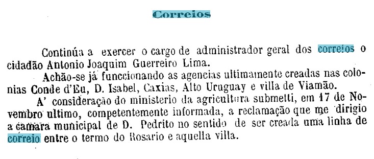
The chapel of N. Sra. da Conceição de Viamão was built by royal decree (Provisão Real) in September 1741 and was located 15 km east of the future provincial capital Porto Alegre. In 1747, the village was elevated to freguesia status and in June 1880, it became a vila in its own município.
The local post office was established in 1881, as can be seen from the first report of the Provincial President for the following year:
Relatório do Presidente da Provincia, 01/1882
The imperial postmark is VRS-0480a (Coll. José A. Junges): a double circle with the inscription VIAMĀO at the top. The only specimen seen so far bears a date from 1889 in the centre.
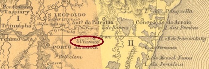
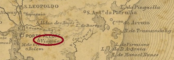
Provincia de São Pedro do Rio Grande, 1877
Die Kapelle von N. Sra. da Conceição de Viamão wurde durch königliche Verfügung (Provisão Real) im September 1741 errichtet und lag 15 km östlich der künftigen Provinzhauptstadt Porto Alegre entfernt. 1747 wurde die Ortschaft zur Freguesia erhoben und im Juni 1880 zur Vila im eigenen Município.
Das örtliche Postamt entstand 1881, wie aus dem ersten Bericht des Provinzpräsidenten für das folgende Jahr zu entnehmen ist:
Relatório do Presidente da Provincia, 01/1882
Der kaiserliche Poststempel ist VRS-0480a (Samml. José A. Junges): ein Doppelkreis mit der Inschrift VIAMĀO oben. Das bisher einzig gesehene Exemplar trägt ein Datum aus 1889 in der Mitte.
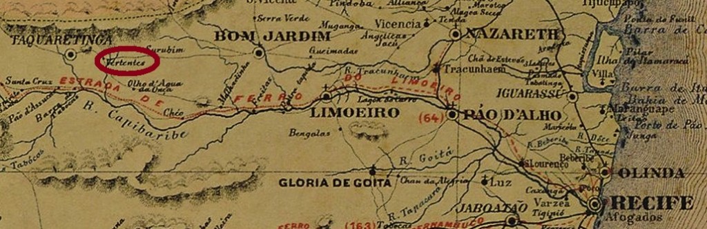
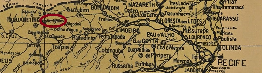
Carta corographica da provincia de Pernambuco, 1880
São José das Vertentes (St. Joseph of the Water Springs) is the name of the old locality which belonged to Vila of Igarassu, located 150 km northwest of the provincial capital Recife. Still in the 19th century, Vertentes changed to the Vila of Limoeiro, before becoming the seat of the município of Taquaretinga in May 1877. This was followed by its ascent to Villa (in June 1879), its relegation as district of Taquaretinga (in April 1892) and its regained administrative autonomy as município (in September 1928).
The local post office was created in 1873, as can be seen from the Directory of Imperial Post Offices (Tabella das Agencias do Correio do Imperio, Rio de Janeiro, 1885). This information is confirmed by the postal report (Relatorio Postal) for 1887. The imperial postmark is VPE-0665a (Coll. Ginaldo Bezerra da Silva), an archaic-looking oval with the inscription CORREIO/VERTENT between two decorated lines. The only specimen so far bears no date and was found on a stamp from 1888.
Arthur D. Ribeiro: Estado de Pernambuco, 1924
São José das Vertentes (St. Joseph der Wasserquellen) hieß der frühere Ort, der zur Vila von Igarassu gehörte und 150 km nordwestlich der Provinzhauptstadt Recife lag. Noch im 19. Jahrhundert wechselte Vertentes zur Vila von Limoeiro, bevor er im Mai 1877 der Sitz des Município von Taquaretinga wurde. Es folgten der Aufstieg zu Villa (im Juni 1879), der Abstieg als Distrikt von Taquaretinga (im April 1892) und die wiedererlangte Verwaltungsautonomie als Município (im September 1928).
Das örtliche Postamt wurde 1873 ins Leben gerufen, wie man dem Verzeichnis der kaiserlichen Postämter (Tabella das Agencias do Correio do Imperio, Rio de Janeiro, 1885) entnehmen kann. Diese Angabe wird durch den Postbericht (Relatorio Postal) für 1887 bestätigt. Der kaiserliche Poststempel ist VPE-0665a (Samml. Ginaldo Bezerra da Silva), eine archaisch anmutende Ovale mit der Inschrift CORREIO/VERTENT zwischen zwei verzierten Zeilen. Das bisher einzige Exemplar trägt kein Datum und wurde auf eine Marke aus 1888 gefunden.
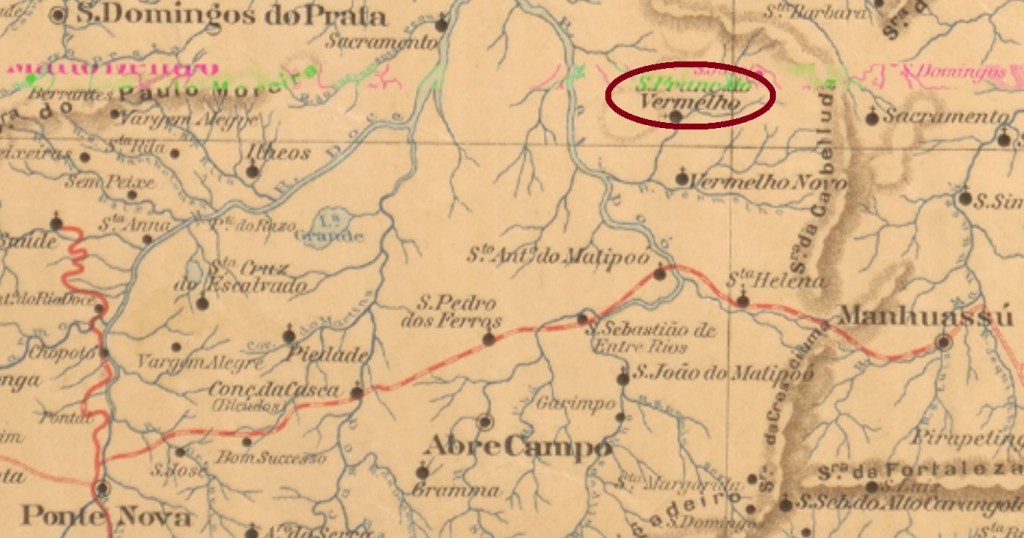
Other names: São Francisco de Assis do Vermelho, São Francisco do Ribeirão Vermelho, Vermelho Velho (1924)
Vermelho is the name of a small tributary of the Matipó, probably because its water had this colouring. The parish of São Francisco de Assis do Vermelho was founded in November 1865 in the Município of Ponte Nova, 170 km east of the provincial capital Ouro Preto. In September 1882, the locality changed as a district of Caratinga and in August 1911, it had slightly shortened the place name to São Francisco do Vermelho. Since September 1924, the place has been called Vermelho Velho and belongs as a district to the Município of Raul Soares. The new name is meant to differ from Vermelho Novo, a later village that lies further south directly on the Vermelho River.
As Paula Sobrinho writes in História Postal de Minas Gerais (Belo Horizonte, 1997), there was a post office there since June 1864. The very first postmark has not yet been found, just its successor VMG-3290b (Coll. José A. Junges): a double circle with the inscriptions VERMELHO above and (MINAS) below, with internal dates from 1887 to 1891.
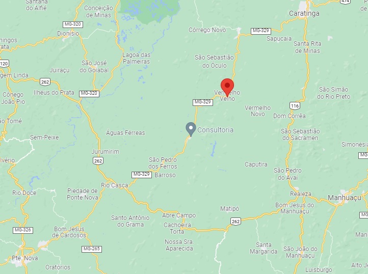
Google Maps
Andere Namen: São Francisco de Assis do Vermelho, São Francisco do Ribeirão Vermelho, Vermelho Velho (1924)
Vermelho heißt ein kleiner Zufluss des Matipó, wohl weil sein Wasser diese Färbung aufwies. Die Pfarrei von São Francisco de Assis do Vermelho wurde im November 1865 im Município von Ponte Nova gegründet und lag 170 km östlich der Provinzhauptstadt Ouro Preto entfernt. Im September 1882 wechselte die Ortschaft als Distrikt von Caratinga und hatte im August 1911 den Ortsnamen zu São Francisco do Vermelho leicht gekürzt. Seit September 1924 heißt der Ort Vermelho Velho und gehört als Distrikt dem Município von Raul Soares. Der neue Name soll den Unterschied zu Vermelho Novo betonen, einer später entstandenen Ortschaft, die weiter südlich direkt am Vermelho-Fluss liegt.
Wie Paula Sobrinho in História Postal de Minas Gerais (Belo Horizonte, 1997) schreibt, gab es dort ein Postamt seit Juni 1864. Der allererste Poststempel wurde noch nicht gefunden, wohl aber VMG-3290b (Samml. José A. Junges): ein Doppelkreis mit den Inschriften VERMELHO oben und (MINAS) unten, mit inneren Daten von 1887 bis 1891.
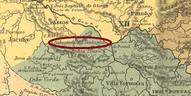
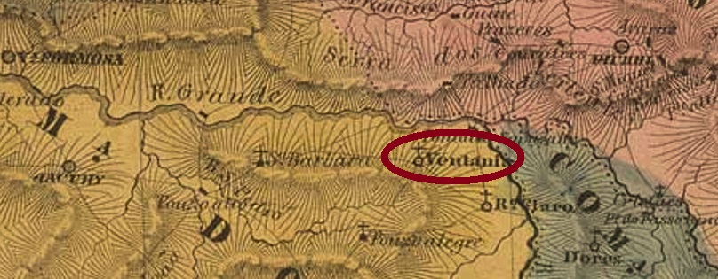
Other names: São Sebastião da Ventania, Alpinópolis (1914)
São Sebastião da Ventania (St. Sebastian of the Strong Winds) was the name given in October 1824 to a settlement near Jacuhy, situated on a hillside more than 400 km west of the provincial capital Ouro Preto. Afterwards, the locality changed its jurisdiction twice as a district: in October 1848 to Passos and in September 1901 to Villa Nova de Resende. In October 1914, the place name changed to Alpinópolis, which has been an independent município since December 1938.
As Paula Sobrinho writes in História Postal de Minas Gerais (Belo Horizonte, 1997), there was a post office there from April 1880. The imperial postmark is the double circle VMG-3280a (Coll. José A. Junges), with the inscriptions VENTANIA at the top and (MINAS) at the bottom. Dates in the centre go from 1886 to 1894.
Villiers de l’Ile Adam: Carta (…) da Provincia de Minas Geraes, 1849
Andere Namen: São Sebastião da Ventania, Alpinópolis (1914)
São Sebastião da Ventania (Hl. Sebastian der Starken Winde) hieß ab Oktober 1824 eine Siedlung bei Jacuhy, die an einem Berghang lag, über 400 km westlich der Provinzhauptstadt Ouro Preto entfernt. Danach wechselte die Ortschaft als Distrikt zweimal ihre Zuständigkeit: im Oktober 1848 zu Passos und im September 1901 zu Villa Nova de Resende. Im Oktober 1914 änderte sich der Ortsname zu Alpinópolis, der seit Dezember 1938 ein eigenständiger Município ist.
Wie Paula Sobrinho in História Postal de Minas Gerais (Belo Horizonte, 1997) schreibt, gab es dort ein Postamt seit April 1880. Der kaiserliche Poststempel ist der Doppelkreis VMG-3280a (Samml. José A. Junges), mit den Inschriften VENTANIA oben und (MINAS) unten. Daten in der Mitte von 1886 bis 1894.
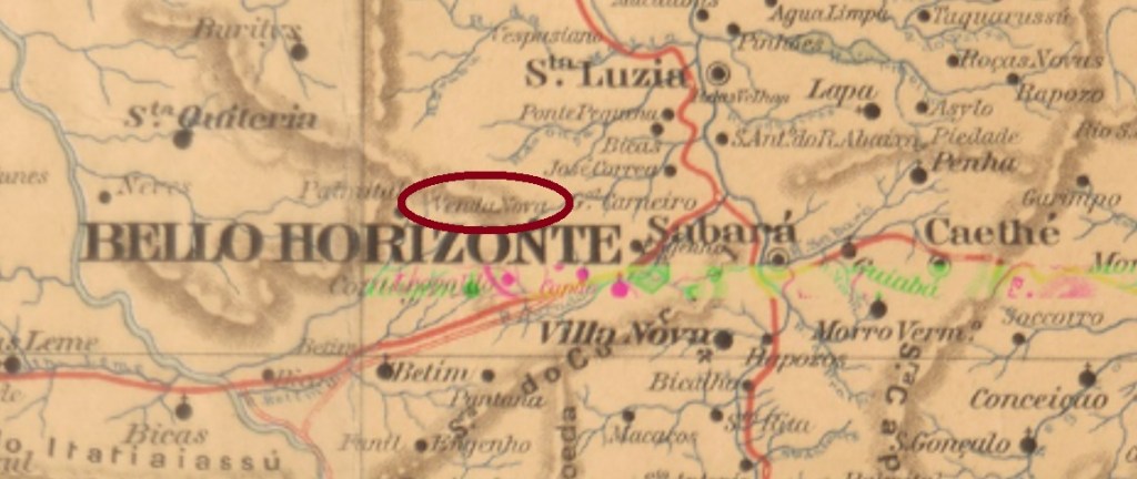
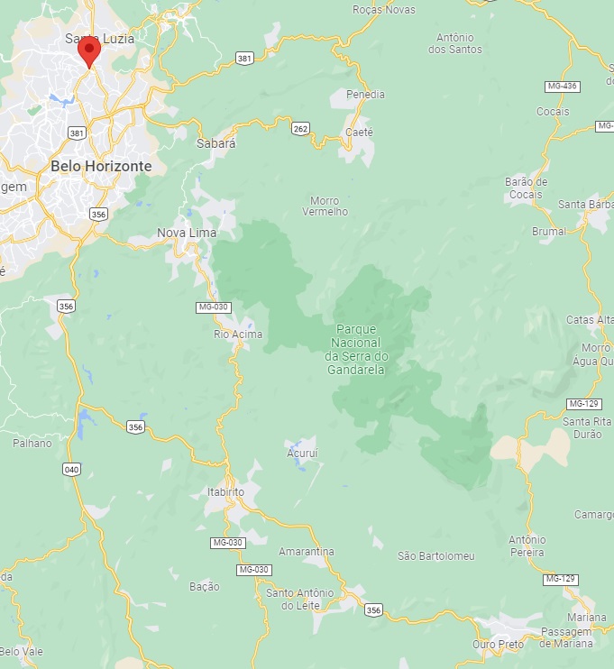
The parish of Nossa Senhora da Venda Nova (Our Lady of the New Store) was established in July 1868 in the Município of Sabará, just under 120 km northwest of the provincial capital of Ouro Preto. Since September 1923, Venda Nova has been a district of the current state capital Belo Horizonte.
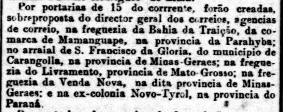
As Paula Sobrinho writes in História Postal de Minas Gerais (Belo Horizonte, 1997), there had been a post office there since November 1882, which is confirmed by the press from Rio de Janeiro:
Jornal do Commercio/RJ, 17.11.1882
The imperial postmark is the double circle VMG-3275a (Coll. José A. Junges), with the inscriptions VENDA NOVA above and (MINAS) below. The dates in the centre have so far been found for the period 1888-1889.
Google Maps
Die Pfarrei von Nossa Senhora da Venda Nova (Unsere Liebe Frau des Neuen Kaufladens) wurde im Juli 1868 im Município von Sabará errichtet und lag knapp 120 km nordwestlich der Provinzhauptstadt Ouro Preto entfernt. Seit September 1923 ist Venda Nova ein Distrikt der aktuellen Landeshauptstadt Belo Horizonte.
Wie Paula Sobrinho in História Postal de Minas Gerais (Belo Horizonte, 1997) schreibt, gab es dort ein Postamt seit November 1882, was durch die Presse aus Rio de Janeiro bestätigt wird:
Jornal do Commercio/RJ, 17.11.1882
Der kaiserliche Poststempel ist der Doppelkreis VMG-3275a (Samml. José A. Junges), mit den Inschriften VENDA NOVA oben und (MINAS) unten. Die Daten in der Mitte wurden bisher für den Zeitraum 1888-1889 gefunden.
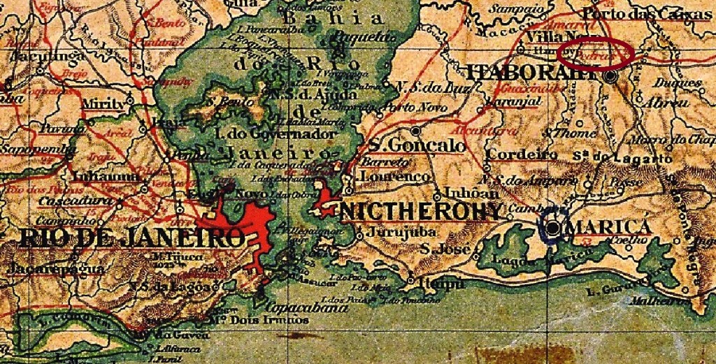
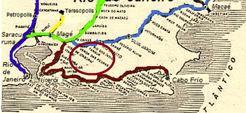
The station Venda das Pedras (shop near the rocks) was inaugurated in December 1874 by the Cia. Ferro-Carril Niteroiense (Coast Line) and was located north of Itaboraí, more than 50 km east of the capital Rio de Janeiro. In 1887 the railway line became the property of E.F. Leopoldina and from 1975 until its closure in 1996 it belonged to Rede Ferroviária Federal S. A. (estacoesferroviarias.com.br).
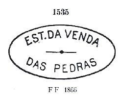
Paulo Novaes writes in agenciaspostais.com.br that there was a post office at the station from January 1875. The first station postmark, VRJ-1725a, remained in circulation until at least 1877 and was already presented by Paulo Ayres in Catálogo de Carimbos Brasil-Império (S. Paulo, 1937, 1942) under no. 1535:
VRJ-1725a (P.A. 1535)
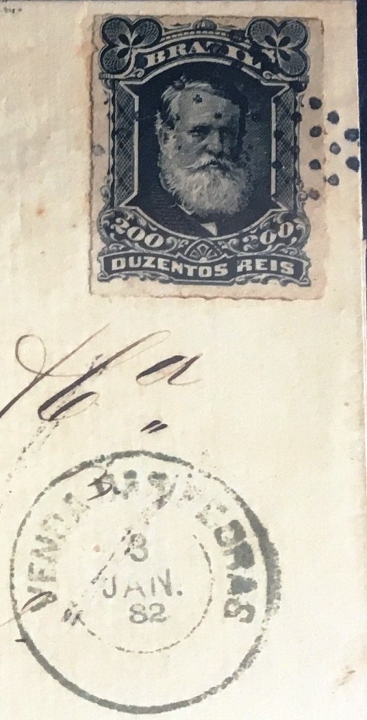
It was followed by three postmarks as double circles. VRJ-1725b (Coll. José A. Junges) has only the inscription VENDA DAS PEDRAS at the top. Two copies found, dated 1881-2 in the centre. VRJ-1725c (Coll. José A. Junges) has the inscription V. DAS PEDRAS at the top. Again, only one example found, dated 1883 in the centre. And VRJ-1725d (Coll. José A. Junges) has the inscription EST. DA VENDA DAS PEDRAS, below you can see an ornament in lozenge, formed by four small lozenges. Dates in the middle from about 1885 to 1889.
Two mute cancellations have also appeared from Venda das Pedras, the first one used 1882 together with VRJ-1725b:
1882 (Coll. Alexandre Andrade)
The second one was used in 1883 in conjunction with VRJ-1725c:
1883 (Coll. José A. Junges)Estrada de Ferro Leopoldina
Textaktualisierung vom 15. Mai 2022
Der Bahnhof Venda das Pedras (Kaufladen an den Steinen) wurde im Dezember 1874 durch die Cia. Ferro-Carril Niteroiense (Küstenlinie) eingeweiht und lag bei Itaboraí, über 50 km östlich der Hauptstadt Rio de Janeiro entfernt. 1887 ging die Bahnlinie in Besitz der E.F. Leopoldina über und von 1975 bis zur Stilllegung 1996 gehörte sie der Rede Ferroviária Federal S. A. (estacoesferroviarias.com.br).
Paulo Novaes schreibt in agenciaspostais.com.br, dass am Bahnhof ab Januar 1875 ein Postamt gab. Der erste Bahnhofspoststempel, VRJ-1725a, blieb im Umlauf bis mindestens 1877 und wurde bereits durch Paulo Ayres in Catálogo de Carimbos Brasil-Império (S. Paulo, 1937, 1942) unter Nr. 1535 vorgestellt:
VRJ-1725a (P.A. 1535)
Ihm folgten drei Poststempel als Doppelkreise. VRJ-1725b (Samml. José A. Junges) hat lediglich oben die Inschrift VENDA DAS PEDRAS. Zwei Exemplare gefunden, datiert 1881-2 in der Mitte. VRJ-1725c (Samml. José A. Junges) hat oben die Inschrift V. DAS PEDRAS. Auch hier nur ein Exemplar vorhanden, datiert 1883 in der Mitte. Und VRJ-1725d (Samml. José A. Junges) hat oben die Inschrift EST. DA VENDA DAS PEDRAS, unten sieht man ein Ornament in Raute, das aus vier kleinen Rauten gebildet wird. Datiert in der Mitte von ca. 1885 bis 1889.
Aus Venda das Pedras sind auch zwei stumme Abstempelungen aufgetaucht; einmal auf einem Brief aus 1882:
1882 (Samml. Alexandre Andrade)
Die zweite wurde 1883 in Verbindung mit VRJ-1725c verwendet:
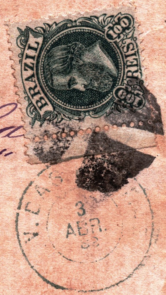
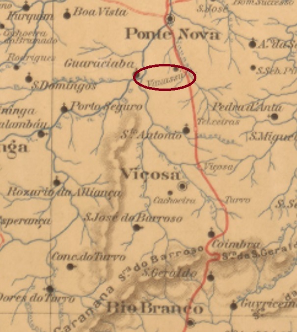
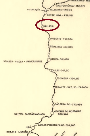
The beautiful old Portuguese word vau means river crossing point, by foot or on horseback. Assú (now spelled açu) is the Indian word for big. Vau-Assu was the name of the stream that gave the name to a fazenda in the Ponte Nova area, a good 90 km east of the provincial capital Ouro Preto. A station of the R.F. Leopoldina Railway Company (Main Line) was inaugurated there in February 1886. From 1975 until its closure in 1994, the railway line belonged to Rede Ferroviária Federal S.A. (estacoesferroviarias.com.br). Since December 1948, Vau-Açu has been a district in the Município of Ponte Nova.
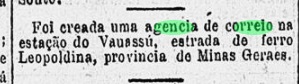
Paula Sobrinho writes in História Postal de Minas Gerais (Belo Horizonte, 1997) that there was a post office at the station from June 1886. This is confirmed by the Rio press:
Gazeta de Noticias/RJ, 18/06/1886
The oldest station postmark so far is VMG-3270a (image from the Internet): a double circle with the inscriptions VAU-ASSU above and (M. GERAES) below. The dates in the middle originate from the period 1897-1900.
Estrada de Ferro Leopoldina
Das schöne, alte portugiesische Wort Vau bedeutet Flussüberquerungspunkt, zu Fuß oder auf dem Pferd. Assú (heute açu geschrieben) ist ein indianisches Wort für groß. Vau-Assu hieß der Bach, der eine Fazenda im Gebiet von Ponte Nova den Namen gab und gut 90 km östlich der Provinzhauptstadt Ouro Preto entfernt lag. Dort wurde im Februar 1886 ein Bahnhof der R.F. Leopoldina Bahngesellschaft (Hauptlinie) eingeweiht. Die Bahnlinie gehörte von 1975 bis zur Stilllegung 1994 der Rede Ferroviária Federal S.A. (estacoesferroviarias.com.br). Seit Dezember 1948 ist Vau-Açu ein Distrikt im Município von Ponte Nova.
Paula Sobrinho schreibt in História Postal de Minas Gerais (Belo Horizonte, 1997), dass es dort am Bahnhof ab Juni 1886 ein Postamt gab. Dies wird durch die Presse aus Rio bestätigt:
Gazeta de Noticias/RJ, 18.06.1886
Der bisher älteste Bahnhofspoststempel ist VMG-3270a (Abb. aus dem Internet): ein Doppelkreis mit den Inschriften VAU-ASSU oben und (M. GERAES) unten. Die Daten in der Mitte entstammen dem Zeitraum 1897-1900.
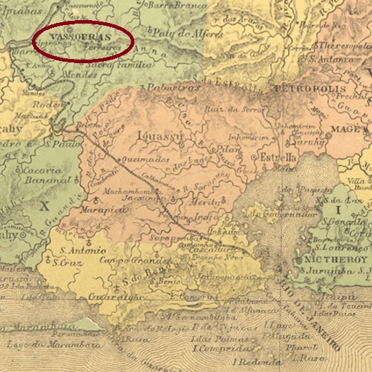
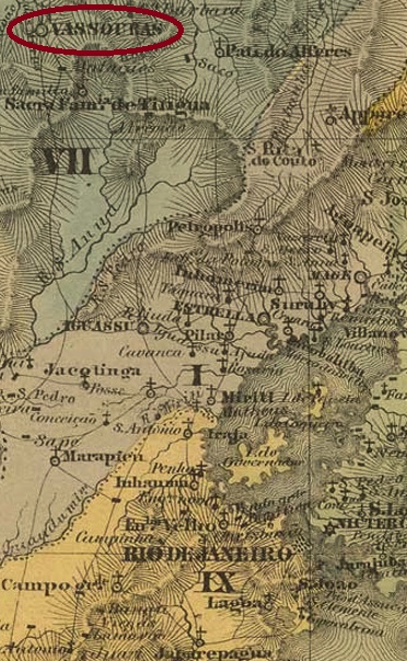
The sesmaria (land area) of Vassouras and Rio Bonito was already mentioned in documents in 1782. It was located 120 km northwest of the future capital Rio de Janeiro and became Nossa Senhora da Conceição da Villa de Vassouras in January 1833. Vassouras has been a city since September 1857.
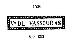
As Nova Monteiro writes in Administrações e Agencias Postaes do Brasil Imperio (Brasil Filatelico/RJ, 1934-5; Reprint SPP 1994-1999), there was a post office there since September 1832. The oldest postmark is probably VRJ-2355a, which was used from 1832 until at least 1843, also occurs in sepia and has already been presented by Paulo Ayres in Catálogo de Carimbos Brasil-Império (S. Paulo, 1937, 1942) under no. 1530 as well as by the RHM catalogue under P-RJ-46:
VRJ-2355a (P.A. 1530, RHM P-RJ-46)
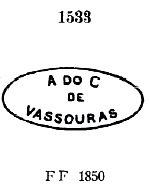
It was followed by VRJ-0990a, which was also listed by Paulo Ayres (No. 1533) and could be found from about 1850:
VRJ-0990a (P.A. 1533) 1850ff
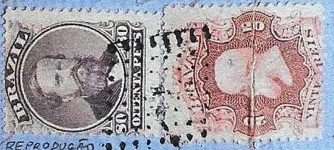
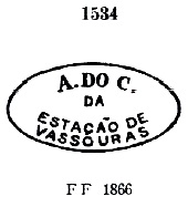
After that there were five stamps as double circles. VEJ-0990b (Coll. Fuad Ferreira Fo.) is a French type with the inscription VASSOURAS above and the star between brackets below. Dates in the centre from 1867 to 1874. VRJ-0990c (Coll. José A. Junges) has the same inscription at the top, but now reads ( C ) at the bottom, for Cidade. Dated from about 1877 to 1882 in the centre. VRJ-0990d (Coll. José A. Junges) has the inscription CID. DE VASSOURAS, below is an ornament in lozenge formed by four small lozenges. The inner dates were found for the period 1884-1887. VRJ-0990e (Coll. José A. Junges) has the inscription CIDE. DE VASSOURAS, below the ornament is now like a hashtag. Dated 1888-1889 in the middle. Finally there comes VRJ-0990f (Coll. José A. Junges): here the inscription above is simply VASSOURAS, below is a 12-pointed star, with internal dates from 1890 to 1893.
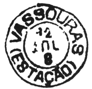
In June 1865, the train station was inaugurated there on the main line of the E.F. Dom Pedro II railway company. The line passed to the E.F. Central do Brasil in 1889, and from 1975 until its closure in 1996 it belonged to Rede Ferroviária Federal S.A. (estacoesferroviarias.com.br). The station was renamed Barão de Vassouras in May 1925. The Directory of Imperial Post Offices (Tabella das Agencias do Correio do Imperio, Rio de Janeiro, 1885) lists the station post office as originating in 1855. This will be a misprint, as much more plausible is the date of 31.12.1865, as recorded by Paulo Novaes in agenciaspostais.com.br.
Three station postmarks were found, starting with VRJ-0991a, which also occurs in blue, was in circulation from 1865 and has already been presented by Paulo Ayres (op.cit.) with no. 1534.
VRJ-0991a (P.A. 1534)
Two postmarks as double circles followed. VRJ-0991b (Coll. José A. Junges) has the inscription EST. DE VASSOURAS at the top, and an ornament in lozenge formed by four small lozenges at the bottom. The internal dates so far go from 1888 to 1890. VRJ-0991c has already been shown by Cicero A. Almeida in Carimbos Postais – século XIX (Rio de Janeiro, 1989) under the no. MPT 800:
VRJ-0991c (MPT 800)
Two mute cancellations from Vassouras have survived. The first one was seen in agenciaspostais.com.br:
1867 (PN)
The other one from the collection José A. Junges:
1882 (JJ)Villiers de l’Ile Adam: Carta (…) da Provincia do Rio de Janeiro, 1850
Die Sesmaria (Landfläche) von Vassouras und Rio Bonito war bereits 1782 urkundlich erwähnt. Sie lag 120 km nordwestlich der künftigen Hauptstadt Rio de Janeiro entfernt und wurde im Januar 1833 zu Nossa Senhora da Conceição da Villa de Vassouras. Seit September 1857 ist Vassouras eine Stadt.
Wie Nova Monteiro in Administrações e Agencias Postaes do Brasil Imperio (Brasil Filatelico/RJ, 1934-5; Reprint SPP 1994-1999) schreibt, gab es dort ein Postamt seit September 1832. Der älteste Poststempel ist wohl VRJ-2355a, der ab 1832 bis mindestens 1843 verwendet wurde, auch in sepia vorkommt und bereits sowohl durch Paulo Ayres in Catálogo de Carimbos Brasil-Império, (S. Paulo, 1937, 1942) unter Nr. 1530 als auch durch den RHM-Katalog unter P-RJ-46 vorgestellt wurde:
VRJ-2355a (P.A. 1530, RHM P-RJ-46)
Ihm folgte VRJ-0990a, der auch bei Paulo Ayres (Nr. 1533) aufgelistet und ab ca. 1850 zu finden war:
VRJ-0990a (P.A. 1533) 1850ff
Danach gab es fünf Stempel als Doppelkreise. VEJ-0990b (Samml. Fuad Ferreira Fo.) ist ein französischer Typus mit der Inschrift VASSOURAS oben und dem Stern zwischen Klammern untern. Daten in der Mitte von 1867 bis 1874. VRJ-0990c (Samml. José A. Junges) hat dieselbe Inschrift oben, unten ist nun ( C ) zu lesen, für Cidade. Datiert ab ca. 1877 bis 1882 in der Mitte. VRJ-0990d (Samml. José A. Junges) hat oben die Inschrift CID. DE VASSOURAS, unten ist ein Ornament in Raute, das aus vier kleinen Rauten gebildet wird. Die inneren Daten wurden für den Zeitraum 1884-1887 gefunden. VRJ-0990e (Samml. José A. Junges) hat oben die Inschrift CIDE. DE VASSOURAS, unten ist das Ornament nun wie ein Hashtag. Datiert 1888-1889 in der Mitte. Schließlich kommt VRJ-0990f (Samml. José A. Junges): hier lautet die obige Inschrift lediglich VASSOURAS, unten ist ein 12-zackiger Stern, mit inneren Daten von 1890 bis 1893.
Im Juni 1865 wurde dort der Bahnhof auf der Hauptslinie der E.F. Dom Pedro II Bahngesellschaft eingeweiht. Die Strecke ging 1889 zur E.F. Central do Brasil über, von 1975 bis zur Stilllegung 1996 gehörte sie der Rede Ferroviária Federal S.A. (estacoesferroviarias.com.br). Der Bahnhof wurde im Mai 1925 zu Barão de Vassouras umbenannt. Das Verzeichnis der kaiserlichen Postämter (Tabella das Agencias do Correio do Imperio, Rio de Janeiro, 1885) listet das Bahnhofspostamt mit Entstehungsjahr 1855 auf. Dies wird ein Druckfehler sein, denn viel plausibler ist das Datum vom 31.12.1865, wie durch Paulo Novaes in agenciaspostais.com.br ermittelt.
Drei Bahnhofspoststempel wurden gefunden, beginnend mit VRJ-0991a, der auch in blau vorkommt, von 1865 an im Umlauf war und durch Paulo Ayres (op.cit.) mit Nr.1534 bereits präsentiert wurde.
VRJ-0991a (P.A. 1534)
Es folgten zwei Poststempel als Doppelkreise. VRJ-0991b (Samml. José A. Junges) hat oben die Inschrift EST. DE VASSOURAS, unten ist ein Ornament in Raute zu sehen, das aus vier kleinen Rauten gebildet wird. Die inneren Daten gehen bisher von 1888 bis 1890.VRJ-0991c wurde bereits gezeigt von Cicero A. Almeida in Carimbos Postais – século XIX (Rio de Janeiro, 1989) unter der Nr. MPT 800:
VRJ-0991c (MPT 800)
Zwei Stumme Entwertungen aus Vassouras sind noch überliefert. Einmal in agenciaspostais.com.br zu sehen:
1867 (PN)
Und einmal wieder aus der Sammlung José A. Junges:
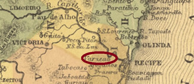
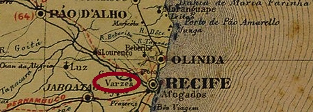
The district of Nossa Senhora do Rosário da Varzea was founded in November 1846 near Recife, more than 10 km west of the city centre. And so it has remained to this day, although since July 1960 the suburb has been part of the administrative zone (Zona Administrativa) in the município of Recife.
The local post office came into being in 1873, as the Directory of Imperial Post Offices (Tabella das Agencias do Correio do Imperio, Rio de Janeiro, 1885) and the Postal Report (Relatorio Postal) for 1887 concur. The oldest imperial postmark is VPE-0660b (Coll. José A. Junges): a plain double circle with the inscription VARZEA at the top. The dates in the middle were found for the period 1885ff-1894.
Carta Corographica da Provincia de Pernambuco, 1880
Der Distrikt von Nossa Senhora do Rosário da Varzea wurde im November 1846 bei Recife gegründet und lag über 10 km westlich der Stadtmitte entfernt. Und so ist es bis heute geblieben, wobei seit Juli 1960 der Vorort zur Verwaltungszone (Zona Administrativa) im Município von Recife gehört.
Das örtliche Postamt entstand 1873, wie das Verzeichnis der kaiserlichen Postämter (Tabella das Agencias do Correio do Imperio, Rio de Janeiro, 1885) und der Postbericht (Relatorio Postal) für 1887 übereinstimmend mitteilen. Der bisherige kaiserliche Poststempel ist VPE-0660b (Samml. José A. Junges): ein schlichter Doppelkreis mit der Inschrift VARZEA oben. Die Daten in der Mitte wurden für den Zeitraum 1885ff-1894 gefunden.
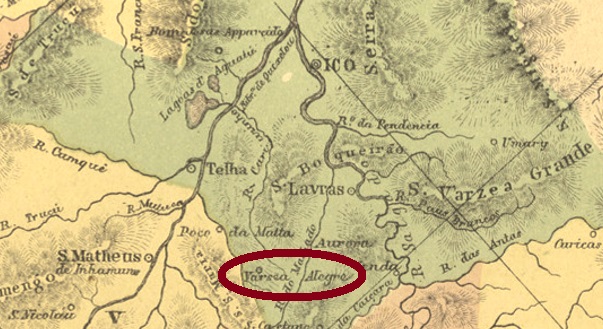
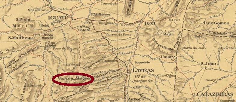
São Raymundo Nonato de Varzea Alegre (also called Vargem Alegre) was a district of Lavras from November 1863, 440 km south of the provincial capital, Fortaleza. In October 1870, it was promoted to vila status and remained so until May 1931, when it was downgraded as a district in the município of Cedro. It was then promoted again as a vila in its own município in December 1933.
There was a post office there since 1874, as can be read in the Directory of Imperial Post Offices (Tabella das Agencias do Correio do Imperio, Rio de Janeiro, 1885). So far, no imperial postmark could be assigned to this municipality with certainty.
Serviço Geologico e Mineralogico do Brasil, 1910
São Raymundo Nonato de Varzea Alegre (auch Vargem Alegre genannt) war ab November 1863 ein Distrikt von Lavras, der 440 km südlich der Provinzhauptstadt Fortaleza entfernt lag. Im Oktober 1870 stieg der Ort zur Vila auf, und so blieb es bis Mai 1931, als die Herabstufung als Distrikt im Município von Cedro stattfand. Der Wiederaufstieg als Vila im eigenen Município erfolgte dann im Dezember 1933.
Dort gab es ein eigenes Postamt seit 1874, wie im Verzeichnis der kaiserlichen Postämter (Tabella das Agencias do Correio do Imperio, Rio de Janeiro, 1885) zu lesen ist. Bisher konnte kein kaiserlicher Poststempel dieser Gemeinde mit Sicherheit zugeordnet werden.