Categories
Carimbologia T-Z

Urubu, Bahia (UBA-0755)

Atlas do Imperio do Brasil, 1868

Other names: Rio Branco, Paratinga (1943)

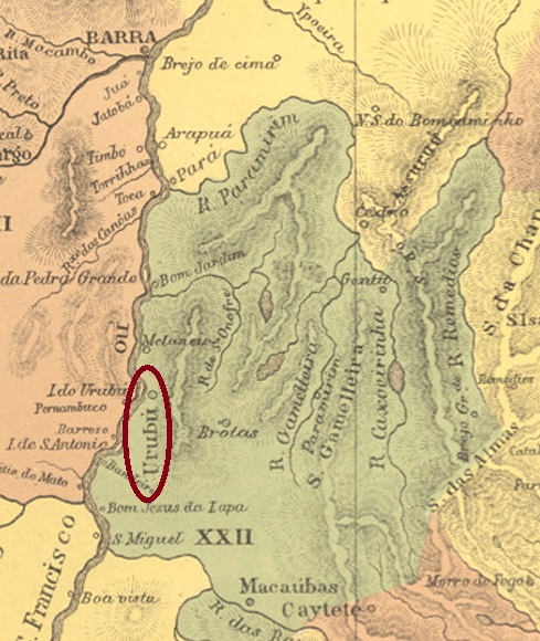
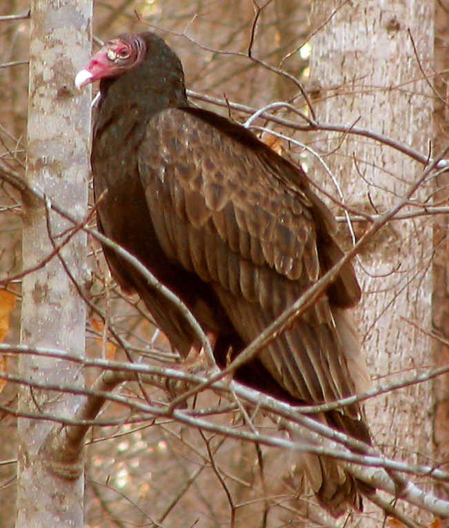
The word Urubu in Brazil refers to both an Indian tribe (also called Kaa’por) and many bird species of the vulture family Cathartidae. However, since the Indians were located further west of Bahia, we can assume that the bird was meant here:

Cathartes aura (Linnaeus, 1758) Photo: Phyzome (CC-BY-SA 3.0)

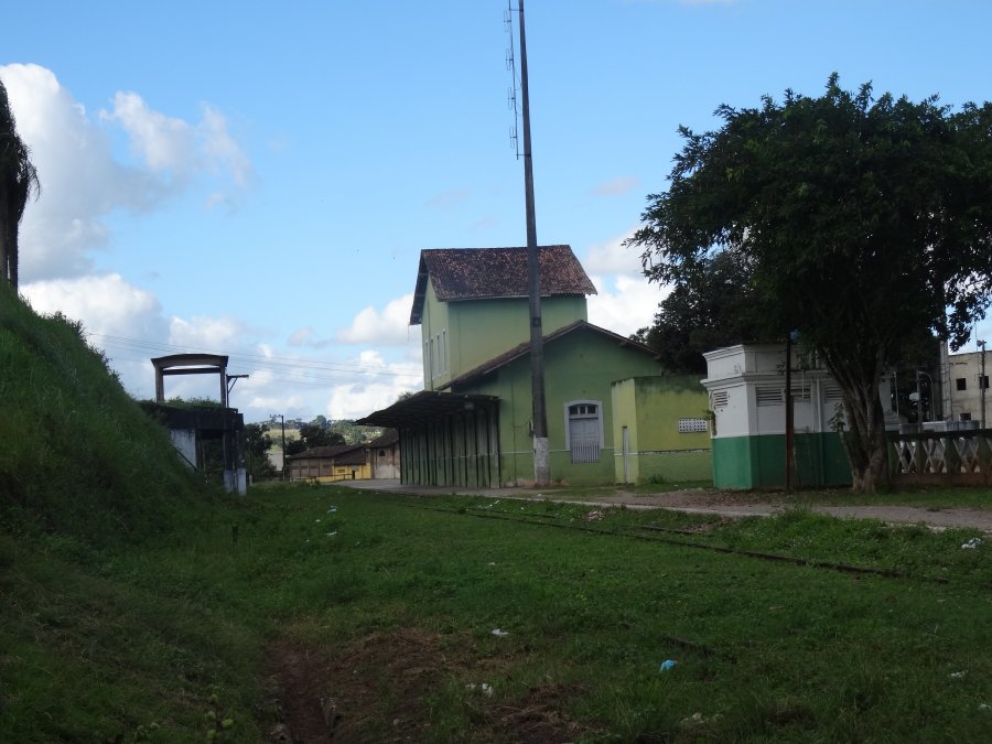
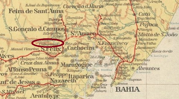
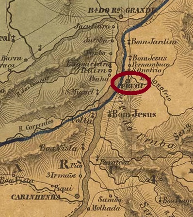
The freguesia of Santo Antonio do Urubu de Cima (St. Anthony on the Upper Vulture) was established as early as 1718 in the Jacobina county, located on the east bank of the Rio São Francisco, 730 km west of the later provincial capital Salvador da Bahia. It was promoted to vila in March 1746, and to town in June 1897. After that, the name changed twice, probably because the local authorities were not comfortable with such denomination: in 1912 to Rio Branco and in 1943 to Paratinga (= Rio Branco/White River, in Tupi-guarani), which is still current today.

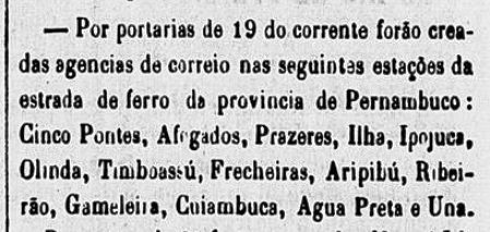
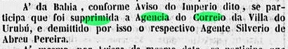
The local post office had at least two periods of operation, although the first beginning could not yet be determined. This first period of operation ended in February 1847, according to the Rio official press:

Gazeta Official/RJ, 24.02.1847

The reopening took place in November 1857, as Nova Monteiro writes in Administrações e Agencias Postaes do Brasil Imperio (Brasil Filatelico/RJ, 1934-5; Reprint SPP 1994-1999). This is confirmed by Aureo G. Santos in Agências de Correio Criadas e Suprimidas 1851, 1855, 1856 e 1857 (Brasil Filatélico 181, Rio de Janeiro, 1977):

Aureo G. Santos (op. cit.)

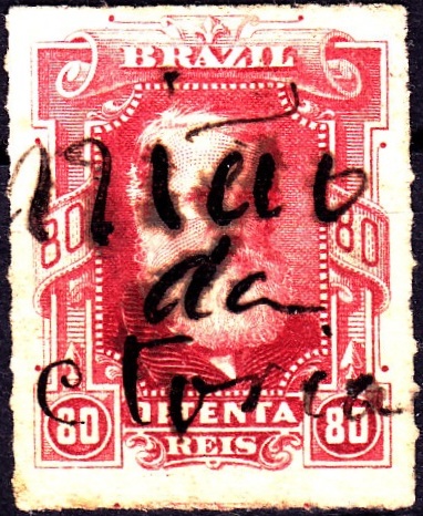
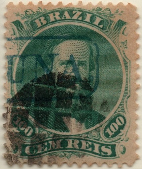
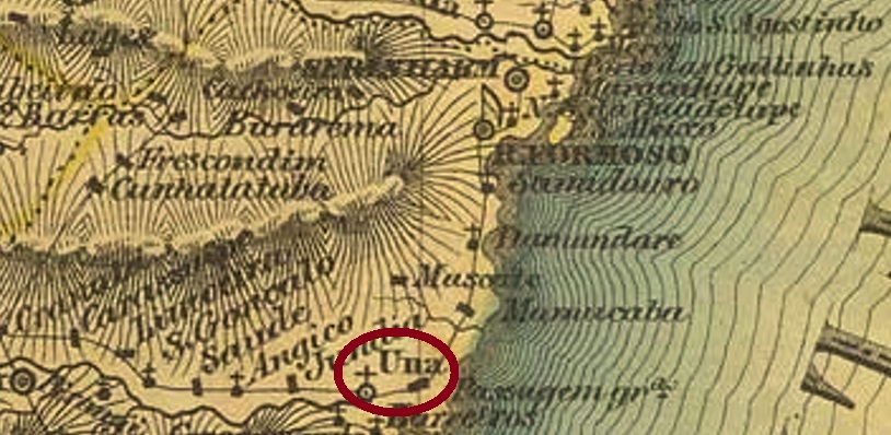
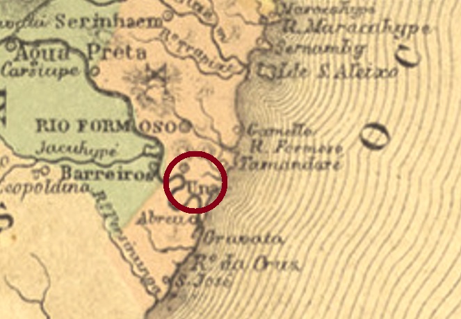
One 19th century postmark has been found, although here too the attribution awaits final confirmation. UBA-0755b (Coll. Klerman W. Lopes) is a double circle with the inscription URUBU above and an (I) below. The only specimen bears a date from 1890 in the centre.

Villiers de l’Ile Adam: Carta (…) da Provincia da Bahia, 1848

Andere Namen: Rio Branco, Paratinga (1943)

Das Wort Urubu bezeichnet in Brasilien sowohl einen Indianerstamm (auch Kaa’por genannt) als auch viele Vogelarten der Geierfamilie Cathartidae. Da aber die Indianer weiter westlich von Bahia beheimatet waren, können wir annehmen, dass hier der Vogel gemeint war:

Cathartes aura (Linnaeus, 1758) Foto: Phyzome (CC-BY-SA 3.0)

Die Freguesia von Santo Antonio do Urubu de Cima (Hl. Antonius am Oberen Assgeier) entstand bereits 1718 in der Gemarkung Jacobina und lag am Ostufer des Rio São Francisco, 730 km westlich der späteren Provinzhauptstadt Salvador da Bahia entfernt. Im März 1746 erfolgte der Aufstieg zur Vila, und im Juni 1897 zur Stadt. Danach wechselte der Name zweimal, wohl weil sich die lokale Obrigkeit nicht mit einem Ort namens Assgeier anfreunden konnte: 1912 zu Rio Branco und 1943 zum heute noch aktuellen Paratinga (= Rio Branco/Weißer Fluss, in Tupi-guarani).

Das lokale Postamt hatte mindestens zwei Betriebsperioden, wobei der erstmalige Beginn noch nicht ermittelt werden konnte. Diese erste Betriebszeit endete im Februar 1847, wie die Amtspresse aus Rio mitteilt:

Gazeta Official/RJ, 24.02.1847

Die Wiedereröffnung fand im November 1857 statt, wie Nova Monteiro in Administrações e Agencias Postaes do Brasil Imperio (Brasil Filatelico/RJ, 1934-5; Reprint SPP 1994-1999) schreibt. Dies wird durch Aureo G. Santos in Agências de Correio Criadas e Suprimidas 1851, 1855, 1856 e 1857 (Brasil Filatélico 181, Rio de Janeiro, 1977) bestätigt:

Aureo G. Santos (op. cit.)

Ein Poststempel des 19. Jahrhunderts wurde gefunden, wobei auch hier die Zuordnung auf eine endgültige Bestätigung wartet. UBA-0755b (Samml. Klerman W. Lopes) ist ein Doppelkreis mit der Inschrift URUBU oben und einem (I) unten. Das einzige Exemplar trägt ein Datum aus 1890 in der Mitte.

Categories
Carimbologia T-Z

União da Victoria, Paraná (UPR-0235)

Atlas do Imperio do Brasil, 1868

Another name: Porto União

The old settlement called Porto União near Palmas became the Freguesia of Porto União de N.Sa. da Victoria in 1855 and was located on the south bank of the river Iguaçu, 230 km south of the provincial capital Curitiba. In April 1880, the place name was simplified to União da Victoria. Ten years later it was promoted to Vila, and since March 1908 União da Vitória (as it is written today) has been a town. Today, the state border with Santa Catarina lies within the city limits. This is the result of a dispute that flared up with the Contestado civil war (1912-1916). A separation throughout the locality called União (Concord)…

As can be seen from the Directory of Imperial Post Offices (Tabella das Agencias do Correio do Imperio, Rio de Janeiro, 1885), there was a post office there since 1880. Probably the postmark was not finished in time, as a handwritten cancellation is known from that period:

1880ff (Coll. Karlheinz Wittig)

The first postmark is probably UPR-0235a (Coll. José A. Junges): a double circle with the above inscription UNIÃO DA VICTORIA, and dates inside from about 1884 to 1892.

Carta da Republica dos Estados Unidos do Brasil, 1892

Anderer Name: Porto União

Die alte Siedlung namens Porto União bei Palmas wurde 1855 zur Freguesia von Porto União de N. Sa. da Victoria und lag am Südufer des Flusses Iguaçu, 230 km südlich der Provinzhauptstadt Curitiba entfernt. Im April 1880 wurde der Ortsname zu União da Victoria vereinfacht. Zehn Jahre später erfolgte der Aufstieg zur Vila, seit März 1908 ist União da Vitória (wie heute geschrieben wird) eine Stadt. Heute liegt die Landesgrenze zu Santa Catarina im Stadtgebiet. Das ist das Ergebnis eines Grenzstreits, der mit dem Contestado-Bürgerkrieg (1912-1916) entflammte. Eine Trennung durch die Stadt, die União (Eintracht) heißt…

Wie aus dem Verzeichnis der kaiserlichen Postämter (Tabella das Agencias do Correio do Imperio, Rio de Janeiro, 1885) hervorgeht, gab es dort ein Postamt seit 1880. Wahrscheinlich wurde der Poststempel nicht rechtzeitig fertig, da aus dieser Zeit eine handschriftliche Entwertung bekannt ist:

1880ff (Samml. Karlheinz Wittig)

Der erste Ortsstempel ist wohl UPR-0235a (Samml. José A. Junges): ein Doppelkreis mit der obigen Inschrift UNIÃO DA VICTORIA, mit Daten im Inneren von ca. 1884 bis 1892.

Categories
Carimbologia T-Z

União, Piauí (UPI-0170)

Atlas do Imperio do Brasil, 1868

The Freguesia of N. Sa. dos Remedios da União came into being in August 1853 and was located on the east bank of the river Parnaiba, 90 km north of the then newly crowned provincial capital Teresina. Only a month later, it was promoted to a vila, and since December 1889, União has been a town.

Two years of origin for the local post office were found. First in March 1856, as Nova Monteiro writes in Administrações e Agencias Postaes do Brasil Imperio (Brasil Filatelico/RJ, 1934-5; Reprint SPP 1994-1999). Then 1880, as listed in the Directory of Imperial Post Offices (Tabella das Agencias do Correio do Imperio, Rio de Janeiro, 1885). There are also two 19th century local postmarks, the first of which has not yet been definitively confirmed.

UPI-0170a was already presented by Paulo Ayres in the Catálogo de Carimbos Brasil-Império (S. Paulo, 1937, 1942) under No. 1522, and Cicero A. Almeida assigned it to the province of Piauí in his Carimbos Postais – século XIX (Rio de Janeiro, 1989) under no. MPT 353:

UPI-0170a (P.A. 1522, MPT 353) 1883ff

Also from Almeida’s work there comes UPI 0170b, which is then clearly from Piauí:

UPI-0170b (MPT 780)
Arthur D. Ribeiro: Estado do Piauhy, 1924

Die Freguesia von N. Sa. dos Remedios da União entstand im August 1853 und lag am Ostufer des Flusse Parnaiba, 90 km nördlich der damals frisch gekürten Provinzhauptstadt Teresina entfernt. Bereits ein Monat später erfolgte der Aufstieg zur Vila, und seit Dezember 1889 ist União eine Stadt.

Zwei Entstehungsjahre fürs örtliche Postamt wurden gefunden. Erstmals im März 1856, wie Nova Monteiro in Administrações e Agencias Postaes do Brasil Imperio  (Brasil Filatelico/RJ, 1934-5; Reprint SPP 1994-1999) schreibt. Dann 1880, wie im Verzeichnis der kaiserlichen Postämter (Tabella das Agencias do Correio do Imperio, Rio de Janeiro, 1885) aufgelistet. Ebenfalls zwei Ortsstempel für den 19. Jahrhundert liegen vor, wobei der erste davon noch nicht endgültig bestätigt ist.

UPI-0170a wurde bereits durch Paulo Ayres im Catálogo de Carimbos Brasil-Império (S. Paulo, 1937, 1942) unter der Nr. 1522 vorgestellt, und Cicero A. Almeida hat ihn der Provinz Piauí in seinem Carimbos Postais – século XIX (Rio de Janeiro, 1989) unter Nr. MPT 353 zugeordnet:

UPI-0170a (P.A. 1522, MPT 353) 1883ff

Auch aus Almeidas Werk kommt UPI 0170b, der dann eindeutig aus Piauí zu erkennen ist:

UPI-0170b (MPT 780)

Categories
Carimbologia T-Z

União (train station/Bahnhof), Rio de Janeiro (URJ-1623)

Estrada de Ferro Leopoldina

See also Rocha Leão (RRJ-2154)

The Rocha Leão train station in the Coastal Line of the Estrada de Ferro Leopoldina was inaugurated in November 1888 near Rio das Ostras (RRJ-0845). Some sources state the original station name was União, but this could not be confirmed. The railway belonged to the E.F. Leopoldina until 1975. From then on until 1996 it was run by the Rede Ferroviária Federal S.A. Now the station house serves as a museum and cultural centre (see image below), and Rocha Leão is a district of Rio das Ostras.

According to Paulo Novaes (agenciaspostais.com.br), the station post office was created in November 1888, which can be confirmed by the regional press:

Gazeta de Noticias, November 17, 1888

A single early cancel is known: RRJ-2154a (image from the internet) has a double circle with the inscription ROCHA LEÃO above and a cross-like ornament below. Dates inside found for 1897-1899.

Almanak Laemmert, 1892

Siehe auch Rocha Leão (RRJ-2154)

Der Bahnhof Rocha Leão wurde im November 1888 durch die Estrada de Ferro Leopoldina in der so genannten Küstenlinie eingeweiht und lag etwas nördlich von Rio das Ostras (RRJ-0845). Einige Quellen behaupten, União war der ursprüngliche Name des Bahnhofs, aber dies konnte nicht bestätigt werden. Die Eisenbahnlinie gehörte bis 1975 der E. F. Leopoldina. Von nun an bis Betriebsende in 1996 war sie Eigentum der Rede Ferroviária Federal S. A. Heute dient das Bahnhofshaus als Museum und Kulturzentrum, und Rocha Leão ist ein Distrikt im Município von Rio Das Ostras.

Laut Paulo Novaes (agenciaspostais.com.br) wurde das Postamt im November 1888 in die Wege geleitet, was auch in der Presse zu lesen ist:

Gazeta de Noticias, 17.11.1888

Ein einziger Stempel der Frühzeit ist überliefert: RRJ-2154a (Abb. aus dem Internet) hat einen Doppelkreis mit der Inschrift ROCHA LEÃO oben und ein kreuzförmiges Ornament unten. Im Gebrauch zwischen 1897 und 1899.

Categories
Carimbologia T-Z

União, Ceará (UCE-0350)

Atlas do Imperio do Brasil, 1868

Other names: Caatinga do Góis, Jaguaruana (1943)

The freguesia of Sant’Anna da União was created in December 1863 and was located in the Município of Aracati, on the west bank of the river Jaguaribe, 180 km southeast of the provincial capital Fortaleza. Exactly two years later the place rose to the status of a vila, it became a town in September 1890 and has been called Jaguaruana since December 1943. The name originates from the Indian language and means Black Jaguar.

The local post office was established in February 1871, according to the regional press:

Cearense, 16.02.1871

So far, no imperial postmark could be assigned with certainty to this locality.

Carta da Republica dos Estados Unidos do Brazil, 1892

Andere Namen: Caatinga do Góis, Jaguaruana (1943)

Die Freguesia von Sant’Anna da União entstand im Dezember 1863 und lag im Município von Aracati am Westufer des Flusses Jaguaribe, 180 km südöstlich der Provinzhauptstadt Fortaleza entfernt. Genau zwei Jahre später stieg der Ort zur Vila auf und wurde im September 1890 eine Stadt, die seit Dezember 1943 Jaguaruana heißt. Der Name aus der Indianersprache bedeutet Schwarzer Jaguar.

Das örtliche Postamt wurde im Februar 1871 ins Leben gerufen, wie die Regionalpresse mitteilte:

Cearense, 16.02.1871

Bisher konnte kein kaiserlicher Poststempel mit Sicherheit dieser Ortschaft zugeordnet werden.

Categories
Carimbologia T-Z

Una, São Paulo (USP-1450)

Atlas do Imperio do Brasil, 1868

This locality was the freguesia of N. Sa. das Dores do Una from August 1811 and was located near São Roque, 70 km west of the provincial capital of São Paulo. Between February 1846 and May 1850, the district belonged to Sorocaba before returning to São Roque. In March 1857, the ascent to the Villa took place, and since November 1944, this Município has been called Ibiúna. The word from the Tupi-Guarani language means dark earth.

The local post office was created in August 1857, according to Nova Monteiro in Administrações e Agencias Postaes do Brasil Imperio (Brasil Filatelico/RJ, 1934-5; Reprint SPP 1994-1999). This is confirmed by Aureo G. Santos in Agências de Correio Criadas e Suprimidas 1851, 1855, 1856 e 1857 (Brasil Filatélico 181, Rio de Janeiro, 1977):

Aureo G. Santos, Brasil Filatelico 181, 1977

Three place stamps were used in the imperial period, which show great similarity among themselves. First USP-1450a (Coll. José A. Junges), which was in circulation between 1857 and 1863: a square with rounded corners showing UNA inside. It was followed by USP-1451b (Coll. José A. Junges), which can only be distinguished from its predecessor by the dot after the A. It is also found in red. It also appears in red and was found between about 1866 and after 1883.

The third town cancel USP-1450c also exists in blue and was already made known by Paulo Ayres under no. 1521. Here the comparison with USP-1450a:

USP-1450c (P.A. 1521) x USP-1450a (JJ) 1866ff-1889ff

A mute cancellation from Una in São Paulo was found in the collection José A. Junges:

1866ff (JJ)
Villiers de l’Ile Adam: Carta (…) da Provincia de São Paulo, 1847

Diese Ortschaft war ab August 1811 die Freguesia von N. Sa. das Dores do Una und lag bei São Roque, 70 km westlich der Provinzhauptstadt São Paulo entfernt. Zwischen Februar 1846 und Mai 1850 gehörte der Distrikt zu Sorocaba, bevor er zu São Roque zurückkehrte. Im Marz 1857 fand der Aufstieg zur Villa statt, und seit November 1944 heißt dieser Município Ibiúna. Das Wort aus der Tupi-Guarani-Sprache bedeutet dunkle Erde.

Das örtliche Postamt wurde im August 1857 ins Leben gerufen, wie Nova Monteiro in Administrações e Agencias Postaes do Brasil Imperio (Brasil Filatelico/RJ, 1934-5; Reprint SPP 1994-1999) schreibt. Dies wird bestätigt durch Aureo G. Santos in Agências de Correio Criadas e Suprimidas 1851, 1855, 1856 e 1857 (Brasil Filatélico 181, Rio de Janeiro, 1977):

Aureo G. Santos, Brazil Philatelico 181, 1977

Drei Ortsstempel wurden in der Kaiserzeit verwendet, die untereinander große Ähnlichkeit aufweisen. Erstmals USP-1450a (Samml. José A. Junges), der zwischen 1857 und 1863 im Umlauf war: ein Viereck mit abgerundeten Ecken, der darinnen UNA zeigt. Ihm folgte USP-1451b (Samml. José A. Junges), der von seinem Vorgänger nur durch den Punkt nach dem A zu unterscheiden ist. Er kommt auch in rot vor und war zwischen ca. 1866 bis nach 1883 zu finden.

Den dritten Ortsstempel USP-1450c gibt es auch in blau und wurde bereits durch Paulo Ayres unter Nr. 1521 bekannt gemacht. Hier der Vergleich mit USP-1450a:

USP-1450c (P.A. 1521) x USP-1450a (JJ) 1866ff-1889ff

Eine stumme Entwertung aus Una in São Paulo wurde in der Samml. José A. Junges entdeckt:

1866ff (JJ)

Categories
Carimbologia T-Z

Una (train station/Bahnhof), Pernambuco (UPE-0731)

Carta Corographica da Provincia de Pernambuco, 1880

See also Trombetas (TPE-0657)

Una station was inaugurated in November 1862 by the E.F. Recife ao São Francisco railway company (Southern Line) and was then located in the Município of Água Preta on the north bank of the Una River, 120 km southwest of the provincial capital Recife. Despite the name, the station did not serve the Freguesia of Una near Rio Formoso (UPE-0730, post office since 1854), but the nearby large estate (Engenho) of Trombeta. The railway line went to the Great Western Company in 1901, to Rede Ferroviária do Nordeste in 1950, and from 1975 until its closure in 1996 it belonged to Rede Ferroviária Federal S.A. (estacoesferroviarias.com.br). Today, the station building houses a cultural foundation dedicated to the writer Hermilo Borba Filho (1917-1976).

ca. 1875 (Commissão Geologica do Imperio, in estacoesferroviarias.com.br)
2016 (Photo: Fernando Marietan, in estacoesferroviarias.com.br)

The station post office was created in December 1864, as reported by the Rio press:

Constitucional/RJ, 24/12/1864

The village between the engenho and the railway station continued to grow, and in September 1866 Trombetas also received its own post office. Shortly after, the population increased very rapidly, due to the arrival of the descendants of escaped slaves from Palmares Quilombo in Alagoas. As early as 1868, the town was elevated to a district called Palmares, and five years later it became a villa, with a population of over 25 thousand by the end of the Empire. Between 1875 and 1879, the station was renamed Palmares.

So far, no postmark of Una station for the imperial period could be identified with certainty. For postmarks with PALMARES see Koester, Carimbologia XXIX.

Carta da Republica dos Estados Unidos do Brazil, 1892

Siehe auch Trombetas (TPE-0657)

Der Bahnhof Una wurde im November 1862 von der E.F. Recife ao São Francisco Bahngesellschaft (Südlinie) eingeweiht und lag damals im Município von Água Preta am Nordufer des Flusses Una, 120 km südwestlich der Provinzhauptstadt Recife entfernt. Trotz des Namens diente der Bahnhof nicht die Freguesia von Una bei Rio Formoso (UPE-0730, Postamt seit 1854), sondern den nahen Großlandbesitz (Engenho) Trombetas. Die Bahnhlinie ging 1901 zur Great Western Gesellschaft, 1950 zur Rede Ferroviária do Nordeste, und von 1975 bis zur Stilllegung 1996 gehörte sie der Rede Ferroviária Federal S.A. (estacoesferroviarias.com.br). Heute beherbergt das Bahnhofsgebäude eine dem Schriftsteller Hermilo Borba Filho (1917-1976) gewidmete Kulturstiftung.

ca. 1875 (Commissão Geologica do Imperio, in estacoesferroviarias.com.br)
2016 (Foto: Fernando Marietan, in estacoesferroviarias.com.br)

Im Dezember 1864 entstand das Bahnhofspostamt, wie die Presse aus Rio berichtet:

Constitucional/RJ, 24.12.1864

Die Ortschaft zwischen dem Engenho und dem Bahnhof wuchs weiter, und im September 1866 erhielt auch Trombetas ein eigenes Postamt. Kurz darauf stieg die Einwohnerzahl sehr rasch, bedingt durch die Ankunft des Nachkommens von geflohenen Sklaven aus dem Quilombo Palmares in Alagoas. Bereits 1868 wurde der Ort zu einem Distrikt namens Palmares erhoben und fünf Jahre später zu einer Villa, die am Ende des Kaiserreichs über 25 Tausend Einwohner hatte. Zwischen 1875 und 1879 wurde der Bahnhof zu Palmares umbenannt.

Bisher konnte kein Poststempel des Bahnhofs Una für die Kaiserzeit mit Sicherheit identifiziert werden. Für Stempel mit PALMARES siehe Koester, Carimbologia XXIX.

Categories
Carimbologia T-Z

Una, Pernambuco (UPE-0730)

Villiers de l’Ile Adam: Carta (…) das Provincias de Pernambuco, Alagoas e Sergipe, 1847

Updated on April 7, 2022

This other locality called Una, in the province of Pernambuco, was already before 1831 the Freguesia of N. Sa. da Purificação e São Gonçalo de Una, which was directly subordinate to Recife, although it was about 100 km south of the main city. In May 1833, the freguesia changed to the Município of Rio Formoso, and 100 years later to the Município of Barreiros. And so it has remained until today as the district of Rio Una at Barreiros.

Two years were found for the creation of the local post office. Firstly in 1854, as noted in the Directory of Imperial Post Offices (Tabella das Agencias do Correio do Imperio, Rio de Janeiro, 1885). Then again in 1877, as shown in the regional press:

 Diario de Pernambuco, 28.05.1877

An imperial postmark of this locality could be assigned with certainty so far, but not the oldest one. UPE-0730b (Coll. Ginaldo Bezerra da Silva) is a double circle with the inscription UNA above and one (2) below. The dates in the middle were found for the period 1887-1890ff.

Atlas do Imperio do Brasil, 1868

Aktualisiert am 07.04.2022

Diese andere Ortschaft namens Una in der Provinz Pernambuco war bereits vor 1831 die Freguesia von N. Sa. da Purificação e São Gonçalo de Una, die direkt Recife unterstellt war, obwohl sie ca. 100 km südlich der Hauptsstadt lag. Im Mai 1833 wechselte die Freguesia zum Município von Rio Formoso, und 100 Jahre später zum Município von Barreiros. Und so es bis heute der Ortsteil Rio Una bei Barreiros geblieben.

Zwei Entstehungsjahre fürs örtliche Postamt wurden gefunden. Erstmals 1854, wie im Verzeichnis der kaiserlichen Postämter (Tabella das Agencias do Correio do Imperio, Rio de Janeiro, 1885) vermerkt. Dann wieder 1877, wie aus der regionalen Presse hervorgeht:

 Diario de Pernambuco, 28.05.1877

Ein kaiserlicher Poststempel dieser Ortschaft konnte bisher mit Sicherheit zugeordnet werden, nicht aber der älteste. UPE-0730b (Samml. Ginaldo Bezerra da Silva) ist ein Doppelkreis mit der Inschrift UNA oben und eine (2) unten. Die Daten in der Mitte wurden für den Zeitraum 1887-1890ff gefunden.

Categories
Carimbologia T-Z

Una, Bahia (UBA-0750)

Villiers de l’Ile Adam: Carta (…) da Provincia da Bahia, 1848

Other names: Barra de Una, Cachoeirinha

This village was a freguesia near Ilhéus from July 1860, located on the north bank of the Una River, 380 km south of the provincial capital Salvador da Bahia. In August 1923, the place – now under the name Cachoeirinha – changed to the newly founded município of Canavieiras. Exactly one year later, it became a vila, and since January 1939 it has again borne the old place name of Una.

The local post office was creatd in February 1885, according to the Rio press:

Jornal do Commercio/RJ, 04.02.1885

So far, no imperial postmark could be surely assigned to this locality.

Atlas do Imperio do Brasil, 1868

Andere Namen: Barra de Una, Cachoeirinha

Diese Ortschaft war ab Juli 1860 eine Freguesia bei Ilhéus, die am Nordufer des Flusses Una lag, 380 km südlich der Provinzhauptstadt Salvador da Bahia entfernt. Im August 1923 wechselte der Ort – nun unter dem Namen Cachoeirinha – zum neu gegründeten Município von Canavieiras. Genau ein Jahr später folgte der Aufstieg zu einer Vila, die seit Januar 1939 den alten Ortsnamen Una wieder trägt.

Das örtliche Postamt entstand im Februar 1885, wie die Presse aus Rio mitteilte:

Jornal do Commercio/RJ, 04.02.1885

Bisher konnte kein kaiserlicher Poststempel mit Sicherheit dieser Ortschaft zugeordnet werden.

Categories
Carimbologia T-Z

Umburanas (Feira de Sant’Anna), Bahia (UBA-0746)

Estado da Bahia, 1913

Other names: Capela de Sto. Estevão, Resgate de Umburanas, Uberlândia, Tinguatiba, Antonio Cardoso (1962)

The second Umburanas with post office in the imperial province of Bahia also has a turbulent history behind it. The former Capela de Santo Estêvão (St. Stephen’s Chapel) rose in April 1843 to become the Freguesia of Nossa Senhora do Resgate de Umburanas in the municipio of Cachoeira and was located close to the north bank of the Paraguaçu River, over 170 km northwest of the provincial capital Salvador da Bahia. In July 1876, the freguesia switched to the município of Feira de Sant’Anna, but returned to Cachoeira two years later. In July 1884, there was another change, this time to the município of São Gonçalo dos Campos. After that, the district was renamed twice: in November 1938 to Uberlândia and in December 1943 to Tinguatiba. It was not until April 1962 that the place would become the município of Antonio Cardoso. The name was supposed to commemorate a political leader of the area, who however was by no means very popular.

The local post office was established in 1876, according to the provincial president’s report for the following year:

Relatorio do Conselho Interino do Governo da Bahia, 1877

The post office must have had a very short operational life, as it was no longer listed in the Imperial Postal Guide (Guia Postal do Imperio) of 1880. No postmark from the Empire has been seen so far.

Google Maps

Andere Namen: Capela de Sto. Estevão, Resgate de Umburanas, Uberlândia, Tinguatiba, Antonio Cardoso (1962)

Die zweite Umburanas mit Postamt in der kaiserlichen Provinz Bahia hat ebenfalls eine bewegte Geschichte hinter sich. Die frühere Capela de Santo Estêvão (St. Stephanskapelle) stieg im April 1843 zur Freguesia de Nossa Senhora do Resgate de Umburanas im Municipio von Cachoeira und lag nah am Nordufer des Flusse Paraguaçu, gut 170 km nordwestlich der Provinzhauptstadt Salvador da Bahia entfernt. Im Juli 1876 wechselte die Freguesia zum Município von Feira de Sant’Anna, kam aber zwei Jahre später zurück zu Cachoeira. Im Juli 1884 gab es einen erneuten Wechsel, diesmal zum Município von São Gonçalo dos Campos. Danach wurde der Distrikt zweimal umbenannt: im November 1938 zu Uberlândia und im Dezember 1943 zu Tinguatiba. Erst im April 1962 stieg der Ort zum Município von Antonio Cardoso auf, der Name soll an einem politischen Führer der Gegend erinnern, der beileibe nicht besonders beliebt war.

Das örtliche Postamt entstand 1876, wie aus dem Bericht des Provinzpräsidenten fürs darauf folgende Jahr hervorgeht:

Relatorio do Conselho Interino do Governo da Bahia, 1877

Das Postamt hatte eine sehr kurze Betriebsdauer, denn es wurde nicht mehr im kaiserlichen Postführer (Guia Postal do Imperio, 1880) aufgelistet. Bisher war kein Poststempel aus dem Kaiserreich zu sehen.