Categories
Carimbologia S

Santo Antonio da Vargem Grande, Rio de Janeiro (SRJ-1350)

Photo: Marcio Martins

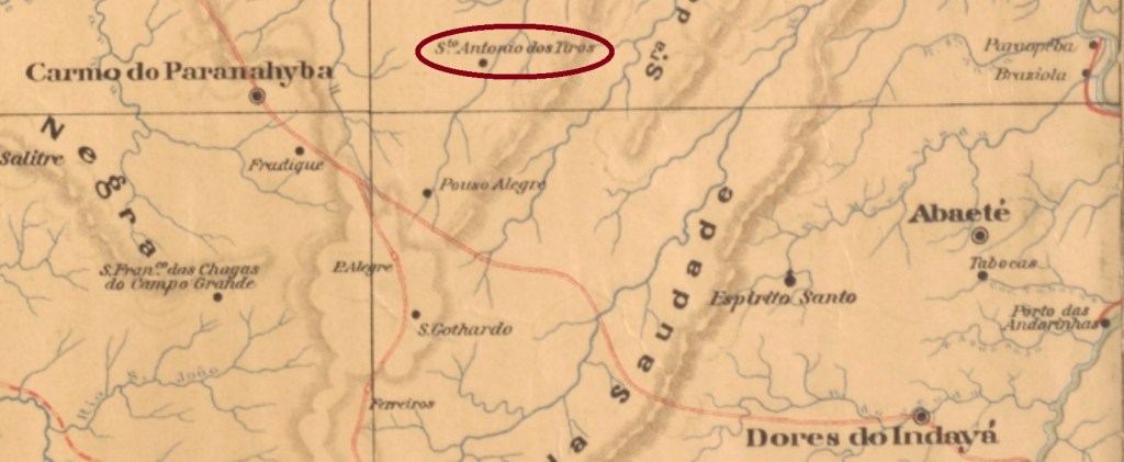
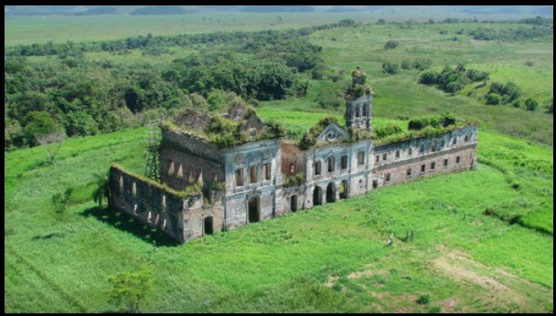
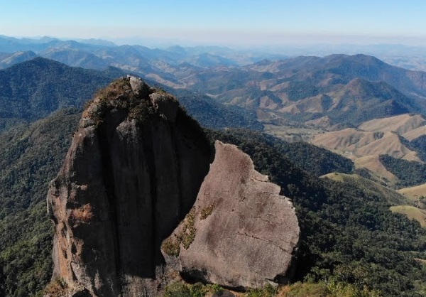
Another name: Pedra Selada (1943)

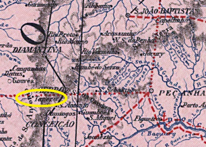
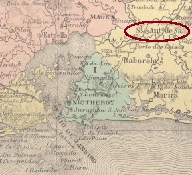
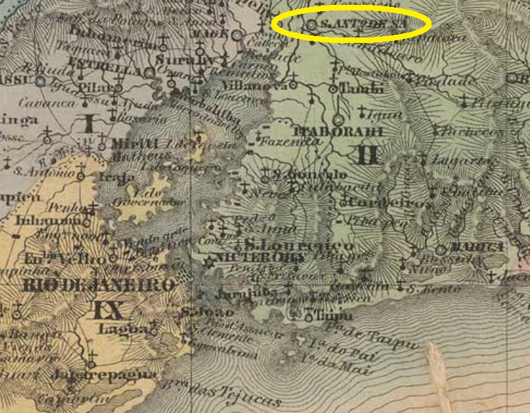
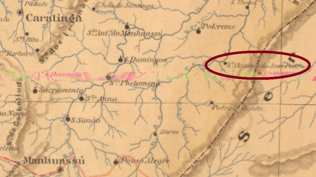
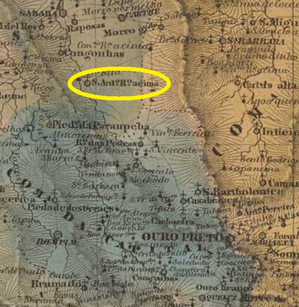
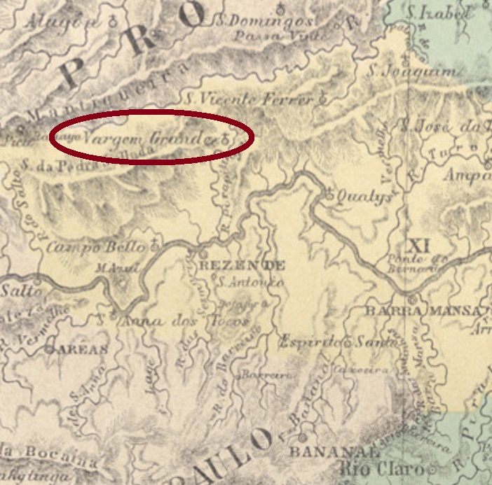
From the beginning in October 1856 until today, Santo Antonio da Vargem Grande has remained a district in the municipality of Resende, situated some 200 km northwest of the imperial capital Rio de Janeiro. In December 1943 the name changed to Pedra Selada, a famous mountain in the region.

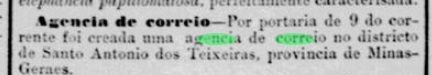
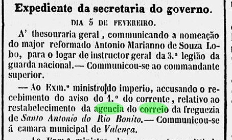
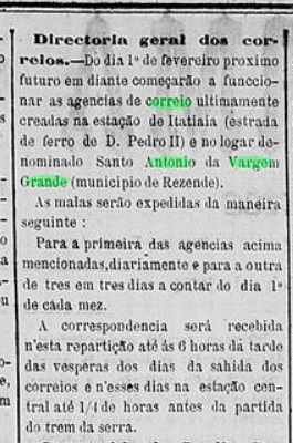
According to the Imperial Mail Register (Tabella das Agencias do Correio do Imperio) of 1885, the local post office was created in 1873. This must have taken place near the year end, for the agency started works only in February 1874, as reported by the regional press:

A Reforma, January 28, 1874

Two Imperial cancels exist. SRJ-1350a (Coll. José A. Junges) has a double circle with the inscription S. A. DA V. GRANDE, dated 1880 at the centre. SRJ-1350b (Coll. José A. Junges) has a slightly modified text between circles: S. A. DA VARGEM GRANDE. The only found example presents a hand written date of 1887 at the centre.

Atlas do Imperio do Brasil, 1868

Anderer Name: Pedra Selada (1943)

Seit der Gründung im Oktober 1856 bis heute erhält Santo Antonio da Vargem Grande den Status eines Distrikts im Município von Resende, etwa 200 km nordwestlich der kaiserlichen Hauptstadt Rio de Janeiro gelegen. Im Dezember 1943 wechselte der Ortsname zu Pedra Selada, wie eine berühmte Bergkuppe der Region heißt (s. Abb. oben).

Laut Verzeichnis der kaiserlichen Postämter (Tabella das Agencias do Correio do Imperio) von 1885 gibt es dort ein Postamt seit 1873. Dessen Entstehung muss aber gegen Jahresende stattgefunden haben, denn die Agentur startete den Betrieb erst im Februar 1874, wie die Presse aus Rio berichtet:

A Reforma, 28. Januar 1874

Zwei Poststempel der Kaiserzeit sind vorhanden. SRJ-1350a (Samml. José A. Junges) hat einen Doppelkreis mit der Inschrift S. A. DA V. GRANDE, dazu Datum aus 1880 in der Mitte. SRJ-1350b (Samml. José A. Junges) hat einen leicht veränderten Text zwischen den Kreisen: S. A. DA VARGEM GRANDE. Das einzig vorhandene Exemplar zeigt ein handgeschriebenes Datum von 1887 in der Mitte.

Categories
Carimbologia S

Santo Antonio dos Tiros, Minas Gerais (SMG-3080)

Mappa de Minas Geraes, 1910

Another name: Tiros (1923)

Santo Antonio dos Tiros was a district in the municipality of Abaeté, established in December 1867 and situated round 400 km northwest of the province capital Ouro Preto. Since September 1923 it is the municipality of Tiros. Tiros means gunshots in Portuguese, this was the name of the local brook.

According to Paula Sobrinho (História Postal de Minas Gerais, Belo Horizonte, 1997), the local post office exists since April 1881. No cancel of the Empire has appeared until now.

Google Maps

Anderer Name: Tiros (1923)

Santo Antonio dos Tiros war ab Dezember 1867 ein Distrikt im Município von Abaeté, der ca. 400 km nordwestlich der Provinzhauptstadt Ouro Preto lag. Seit September 1923 ist es der Município von Tiros. Das portugiesische Wort bedeutet Waffenschüsse, und so hieß der Bach im Ort.

Wie Paula Sobrinho in seiner História Postal de Minas Gerais (Belo Horizonte, 1997) berichtet, gibt es dort ein Postamt seit April 1881. Kein Poststempel des Kaiserreichs war bisher zu sehen.

Categories
Carimbologia S

Santo Antonio dos Teixeiras, Minas Gerais (SMG-3075)

Mappa de Minas Geraes, 1910

Another name: Teixeiras (1938)

This Santo Antonio dos Teixeiras was from October 1883 on a district in the municipality of Viçosa (the former Santa Rita do Turvo), situated round 100 km east of the province capital Ouro Preto. The name celebrates a pioneer family that had settled in the region around 1850. The locality emancipated politically in December 1938 under the actual name of Teixeiras.

Paula Sobrinho writes in his História Postal de Minas Gerais (Belo Horizonte, 1997) that the local post office was created in September 1896, i.e. already in the republic. This is rather a mistake or a reopening date, because cancels from there appeared with dates from 1885 on. Indeed, the Postal Report for 1890 lists this agency with the more plausible creation date of August 9, 1884. This is confirmed by the Rio press:

Jornal do Commercio, RJ, August 10, 1884

One imperial cancel is recorded: SMG-3075a (Coll. Karlheinz Wittig) has a double circle with the inscription S. ANTONIO DOS TEIXEIRAS above and a five-leg starfish below. The dates at the centre were found for 1885-1897.

Google Maps

Anderer Name: Teixeiras (1938)

Santo Antonio dos Teixeiras war ab Oktober 1883 ein Distrikt im Município von Viçosa (ehemals Santa Rita do Turvo), der rund 100 km östlich der Provinzhauptstadt Ouro Preto entfernt lag. Der Name soll an die Pionierfamilie erinnern, die sich ab ca. 1850 in diesem Gebiet niedergelassen hatte. Die Ortschaft erhielt die politische Eigenständigkeit im Dezember 1938, als Município von Teixeiras.

Paula Sobrinho schreibt in seiner História Postal de Minas Gerais (Belo Horizonte, 1997), dass es dort erst seit September 1896 – d.h. bereits in der Republik – ein Postamt gibt. Das ist entweder ein Wiedereröffnungsdatum oder ein Druckfehler, da örtliche Poststempel ab 1885 auffindbar waren. Vielmehr listet der 1890er-Postbericht diese Agentur ab 9. August 1884 auf. Dieses Datum ist plausibler und kann durch die Rio-Presse bestätigt werden:

Jornal do Commercio, RJ; 10. August 1884

Ein Stempel der Kaiserzeit ist überliefert: SMG-3075a (Samml. Karlheinz Wittig) hat einen Doppelkreis mit der Inschrift S. ANTONIO DOS TEIXEIRAS oben und einem fünfbeinigen Seestern unten. Daten in der Mitte zwischen 1885 und 1897.

Categories
Carimbologia S

Santo Antonio do Tará, Pernambuco (SPE-0590)

Google Maps

Other names: Tará, Santo Antônio (1986)

The history Santo Antonio do Tará has begun as a settlement in the municipality of Buique, situated ca. 250 km southwest of the province capital Recife. The word tará has probably Indian origin and named a mountain range of the region. In April 1893 the district changed to the new municipality of Pedra, it is called simply Santo Antonio since June 1986.

According to the Postal Report for 1887, the local post office was created in 1885. No cancel from the Empire has appeared until now.

Serra do Tará (Photo: Adelson Pereira)

Andere Namen: Tará, Santo Antônio (1986)

Die Geschichte dieser Ortschaft begann als eine Siedlung im Município von Buique, die ca. 250 km südwestlich der Provinzhauptstadt Recife entfernt lag. Das Wort tará ist wohl indianischen Ursprungs und nannte eine Bergkette der Region. Im April 1893 wechselte der Distrikt zum Município von Pedra, und im Juni 1986 wurde sein Name zu Santo Antonio vereinfacht.

Der Postbericht für 1887 listet das örtliche Postamt ab 1885 auf. Kein Stempel der Kaiserzeit war bisher zu sehen.

Categories
Carimbologia S

Santo Antonio da Tapera, Minas Gerais (SMG-2990)

Atlas do Imperio do Brasil, 1868

Other names: Tapera, Santo Antonio do Norte (1938)

Santo Antonio da Tapera (= of the Mud Hut) was a district of the municipality of Conceição do Serro, established in June 1858 and situated ca. 250 km north of the provincial capital Ouro Preto. It kept this administrative status until today, but is called Santo Antonio do Norte since December 1938, while the municipality’s name today is Conceição do Mato Dentro. The local population has also considerably shrunk in the meantime: from over 3.3 thousand in 1880 to 662 souls in 2010.

Paula Sobrinho (História Postal de Minas Gerais, Belo Horizonte, 1997) tells us that the local post office was created in June 1884. One single cancel of the Empire has been found: SMG-2990a (Coll. Márcio Protzner) has a double circle with the inscription S. ANTONIO DA TAPERA above and an x-form ornament below, dated 1886 at the centre.

Carta da Republica dos Estados Unidos do Brazil, 1892

Andere Namen: Tapera, Santo Antonio do Norte (1938)

Santo Antonio da Tapera (= der Lehmhütte) war ab Juni 1858 ein Distrikt im Município von Conceição do Serro, der ca. 250 km nördlich der Provinzhauptstadt Ouro Preto entfernt lag. Dieser Verwaltungsstatus gilt bis heute, aber die Ortschaft heißt seit Dezember 1938 Santo Antonio do Norte, und der Município nennt sich heute Conceição do Mato Dentro. Auch die Ortsbevölkerung ist seitdem merklich geschrumpft: von über 3.300 (1880) zu 662 Einwohnern im Jahr 2010.

Paula Sobrinho (História Postal de Minas Gerais, Belo Horizonte, 1997) schreibt den Juni 1884 als Entstehungsdatum fürs örtliche Postamt. Nur ein Stempel aus der Kaiserzeit wurde bisher gefunden: SMG-2990a (Samml. Márcio Protzner) hat einen Doppelkreis mit der Inschrift S. ANTONIO DA TAPERA oben und einem X-förmigen Ornament unten, datiert 1886 in der Mitte.

Categories
Carimbologia S

Santo Antonio de Sá, Rio de Janeiro (SRJ-0905)

Photo: Magno Pereira

Another name: Sambaetiba (1910)

This location won’t be found on any actual map, because the villa does not exist anymore since 1875. The former freguesia of Santo Antonio do Caceribu was created as early as February 1647 near Itaborahy, ca. 60 km northeast of the later colony capital Rio de Janeiro. At that time, Brazil’s capital was still Salvador da Bahia. In August 1697 it was elevated to the villa of Santo Antonio de Sá, a tribute to the Portuguese Sá family, which founded and governed Rio de Janeiro during at least half a century. The villa was officially extinguished in 1875, at the end of a decline period caused by an increase of tropical deseases related to the massive and fast deforestation in the region. Possibly one of Brazil’s earliest ecologic desasters. There are still a few traces of this villa nowadays, the most important are the ruins of the São Boaventura cloister near the Macacu delta in Itaboraí (see above).

Atlas do Imperio do Brasil, 1868

After loosing the villa status, Santo Antonio de Sá became a district of Itaborahy in May 1892, which was renamed to the actual Sambaetiba in October 1910.

According to Nova Monteiro (Administrações e Agencias Postaes do Brasil Imperio, in Brasil Filatelico/RJ, 1934-5; Reprint SPP 1994-1999), the local post office was created in January 1820. Paulo Novaes (agenciaspostais.com.br) tells us it closed in September 1897. No postal cancel of the Empire was seen until now.

Villiers de l’Ile Adam: Carta (…) da Provincia do Rio de Janeiro, 1850

Anderer Name: Sambaetiba (1910)

Diese Ortschaft steht auf keiner Karte heutzutage: die Villa existiert seit 1875 nicht mehr. Die ehemalige Freguesia von Santo Antonio do Caceribu entstand bereits in Februar 1647 nahe Itaborahy, ca. 60 km nordöstlich der späteren kolonialen Hauptstadt Rio de Janeiro. (Damals war noch Salvador da Bahia die Hauptstadt.) Im August 1697 stieg sie zur Villa von Santo Antonio de Sá, als eine Hommage an die portugiesische Familie Sá, die Rio de Janeiro sowohl gegründet als auch über einem halben Jahrhundert lang regiert hat. Das Ende der Villa 1875 war der Schlusspunkt einer langen Dekadenz, die durch tropische Krankheiten verursacht wurde, die wiederum von der massiven und raschen Waldabholzung in der Region begünstigt waren. Diese war womöglich eine der ersten ökologischen Katastrophen Brasiliens. Unter den letzten Spuren der verschwundenen Ortschaft ist die Klosterruine São Boaventura die wichtigste, die sich nah am Macacu-Delta befindet (siehe ganz oben). Nach dem Ende als Villa wurde Santo Antonio de Sá im Mai 1892 ein Distrikt im Município von Itaborahy, der seit Oktober 1910 Sambaetiba heißt.

Laut Nova Monteiro (Administrações e Agencias Postaes do Brasil Imperio, in Brasil Filatelico/RJ, 1934-5; Reprint SPP 1994-1999) entstand das örtliche Postamt im Januar 1820. Paulo Novaes (agenciaspostais.com.br) berichtet über eine Postschließung im September 1897. Kein Stempel der Kaiserzeit war bisher zu sehen.

Categories
Carimbologia S

Santo Antonio do Rio José Pedro, Minas Gerais (SMG-3060)

Provincia de Minas Geraes, 1873

Other names: Sto. Antonio do José Pedro, Rio José Pedro, José Pedro, Ipanema (1928)

The Rio José Pedro has its source in the Caparaó mountains and flows about 200 km towards north along the border between Espirito Santo and Minas Gerais, until its mouth on the right bank of the Manhuaçu River. Santo Antonio do Rio José Pedro was since July 1879 a district in the municipality of Manhuassu, situated over 260 km east of the provincial capital Ouro Preto. In August 1911 the locality emancipated politically as the municipality of Rio José Pedro, which has twice changed the name since then: to José Pedro in September 1923 and to the actual Ipanema five years later. This tupi word means dirty water.

According to the 1890 Postal Report, the local post office was created in October 1883. Another source writes October 1889, but this is probably a misprint, for earlier cancels have been found, under SMG-3060a (Coll. José A. Junges): a double circle featuring the inscription S. ANTONIO DO RIO JOSÉ PEDRO above and a five-leg star below. The dates at the centre are from 1887 until 1894.

GoogleMaps

Andere Namen: Sto. Antonio do José Pedro, Rio José Pedro, José Pedro, Ipanema (1928)

Der José-Pedro-Fluss hat seine Quelle im Caparaó-Gebirge und fließt ca. 200 km nordwärts entlang der Grenze zwischen Espirito Santo und Minas Gerais bis zur Mündung am rechten Ufer des Manhuaçu. Santo Antonio do Rio José Pedro war ab Juli 1879 ein Distrikt im Município von Manhuassu, der über 260 km östlich der Provinzhauptstadt Ouro Preto lag. Im August 1911 erlangte die Ortschaft ihre politische Eigenständigkeit als der Município von Rio José Pedro. Seitdem wechselte der Ortsnamen zweimal: zu José Pedro im September 1923 und zum aktuellen Ipanema fünf Jahre später. Das Tupi-Wort bedeutet schmutziges Gewässer.

Laut dem Postbericht für 1890 gab es dort ein Postamt seit Oktober 1883. Andere Quelle schreibt dafür den Oktober 1889, aber das wird wohl ein Druckfehler sein, da frühere Stempel existieren. Und zwar als SMG-3060a (Samml. José A. Junges): ein Doppelkreis mit der Inschrift S. ANTONIO DO RIO JOSÉ PEDRO oben und einem fünfzackigen Stern unten. Die Daten in der Mitte gehen von 1887 bis 1894.

Categories
Carimbologia S

Santo Antonio do Rio do Peixe, Minas Gerais (SMG-3055)

Atlas do Imperio do Brasil, 1868

Another name: Alvorada de Minas (1962)

This Santo Antonio of the Fish River was since April 1831 a district in the municipality of Serro, situated on the west bank of the Rio do Peixe, over 250 km north of the province capital Ouro Preto. The Rio do Peixe is an affluent to the Santo Antonio River which originates in the Serro Mountains, on the opposite side of the Jequitinhonha River source. The political emancipation came in December 1962, when the locality became the municipality of Alvorada de Minas.

According to Paula Sobrinho (História Postal de Minas Gerais, Belo Horizonte, 1997), the local post office was created in June 1879. The only imperial post cancel found until now is SMG-3055a (Coll. José A. Junges): a double circle with the inscription S. ANTONIO DO RIO DO PEIXE above and a diamond ornament below, formed by four small diamonds. The dates at the centre are from 1885 until 1896.

Provincia de Minas Geraes, 1873

Anderer Name: Alvorada de Minas (1962)

Dieser Santo Antonio vom Fischfluss war ab April 1831 ein Distrikt im Município von Serro, der am Westufer des Rio do Peixe, über 250 km nördlich der Provinzhauptstadt Ouro Preto lag. Der Rio do Peixe ist ein Zufluss des Santo Antonio River, der im Serro-Gebirge entspringt – gegenüber der Quelle des Jequitinhonha-Flusses. Die Ortschaft erhielt die politische Selbständigkeit im Dezember 1962, als sie der Município von Alvorada de Minas wurde.

Wie Paula Sobrinho in seiner História Postal de Minas Gerais (Belo Horizonte, 1997) berichtet, gibt es dort ein Postamt seit Juni 1879. Der einzige bisher gefundene Poststempel im Kaiserreich ist SMG-3055a (Samml. José A. Junges): ein Doppelkreis mit der Inschrift S. ANTONIO DO RIO DO PEIXE oben und einem Rautenornament unten, der aus vier kleinen Rauten besteht. Die Daten in der Mitte gehen von 1885 bis 1896.

Categories
Carimbologia S

Santo Antonio do Rio Bonito, Rio de Janeiro (SRJ-0910)

Atlas do Imperio do Brasil, 1868

Other names: Rio Bonito de Valença, Conservatória (1938)

Santo Antonio do Rio Bonito (= of the Beautiful River) was since March 1839 a district in the municipality of Valença, situated round 150 km northwest of the imperial capital Rio de Janeiro. The Rio Bonito is an affluent on the left bank of the Rio das Flores, but barely visible on actual maps. In March 1938 the district was given the actual toponym Conservatória.

According to Nova Monteiro (Administrações e Agencias Postaes do Brasil Imperio, in Brasil Filatelico/RJ, 1934-5; Reprint SPP 1994-1999), the local post office was created in February 1849, which can be ratified by the local press:

Diário do Rio de Janeiro, February 17, 1849

However, the official text mentions a restabelecimento (re-establishment), thus suggesting the existence of an earlier agency on place, which has been closed in the interim. Three early post cancels were found; the oldest of them, SRJ-0910a, circulated supposedly from 1849 until at least 1878 and was already presented by Paulo Ayres in his Catálogo de Carimbos Brasil-Império (S. Paulo, 1937,1942) under # 1449:

SRJ-0910a (P.A. 1449)

In Ayres’ image of SRJ-0910a there is a missing dot after BONITO. There followed SRJ-0910b (Coll. Karlheinz Wittig): a double circle with the inscription S.A. DO R. BONITO. The dates in the inner circle go from 1879 to 1889. The last cancel may be already republican, for it shows dates of 1894-1895 inside. SRJ-0910c (Coll. Paulo Novaes) has a double circle with the inscription S. ANT. DO RIO BONITO above and an ornament below, unfortunately not clearly visible in the observed examples.

Villiers de l’Ile Adam: Carta (…) da Provincia do Rio de Janeiro, 1850

Andere Namen: Rio Bonito de Valença, Conservatória (1938)

Santo Antonio do Rio Bonito (= vom Schönen Fluss) war ab März 1839 ein Distrikt im Município von Valença, der rund 150 km nordwestlich der kaiserlichen Hauptstadt Rio de Janeiro lag. Der Rio Bonito ist ein Zufluss am linken Ufer des Rio das Flores, heute aber kaum auf Karten zu finden. Im März 1938 erhielt der Distrikt den aktuellen Namen Conservatória.

Laut Nova Monteiro (Administrações e Agencias Postaes do Brasil Imperio, in Brasil Filatelico/RJ, 1934-5; Reprint SPP 1994-1999) gibt es dort ein Postamt seit Februar 1849, was dudrch die Regionalpress bestätigt wird:

Diário do Rio de Janeiro, 17. Februar 1849

Gleichwohl wird hier von offizieller Seite ein restabelecimento (Wiedererrichtung) erwähnt, und damit die Existenz einer früheren Agentur dort angedeutet, die dann geschlossen wurde. Drei frühe Poststempel waren auffindbar; der Älteste davon, SRJ-0910a, war wohl von 1849 an bis mindestens 1878 im Umlauf und wurde bereits durch Paulo Ayres in seinem Catálogo de Carimbos Brasil-Império (S. Paulo, 1937, 1942) unter Nr. 1449 vorgestellt:

SRJ-0910a (P.A. 1449)

In Ayres’ Abbildung fehlt dennoch ein Punkt nach BONITO. Der zweite Stempel ist SRJ-0910b (Samml. Karlheinz Wittig): ein Doppelkreis mit der Inschrift S.A. DO R. BONITO. Die Daten in inneren Kreis gehen von 1879 bis 1889. Der letzte Stempel wäre vielleicht schon republikanisch, da seine Daten um 1894-1895 liegen. SRJ-0910c (Samml. Paulo Novaes) hat einen Doppelkreis mit der Inschrift S. ANT. DO RIO BONITO oben und einem Ornament unten, das leider nicht klar leserlich ist.

Categories
Carimbologia S

Santo Antonio do Rio Acima, Minas Gerais (SMG-3050)

Atlas do Imperio do Brasil, 1868

Another name: Rio Acima (1923)

Santo Antonio do Rio Acima (= of the Upper Course) was since April 1839 a district in the municipality of Sabará, situated ca. 70 km northwest of the provincial capital Ouro Preto. Oddly enough, the river hier is not the Santo Antonio – as in Santo Antonio do Rio Abaixo (SMG-3045) – but the legendary Rio das Velhas, an affluent to the São Francisco which flows through most prominent regions in imperial Minas Gerais. The locality went in February 1891 to Nova Lima and got the name simplified as Rio Acima in September 1923. It became emancipated in December 1948 as the municipality of Rio Acima.

According to Paula Sobrinho (História Postal de Minas Gerais, Belo Horizonte, 1997), the local post office was created in February 1880, but closed in November 1932. One early cancel has been found, whose dates, however, are already republican until now: SMG-3050a (Coll. Márcio Protzner) has a double circle with the inscription S. ANTONIO DO RIO ACIMA above and a diamond ornament below, formed by four small diamonds. Dates at the centre, between 1895 and 1898.

Villiers de l’Ile Adam: Carta (…) da Provincia de Minas Geraes, 1849

Anderer name: Rio Acima (1923)

Santo Antonio do Rio Acima (= am Oberlauf) war ab April 1839 ein Distrikt im Município von Sabará, der ca. 70 km nordwestlich der Provinzhauptstadt Ouro Preto entfernt lag. Merkwürdigerweise ist der Fluss hier nicht der Santo Antonio – wie bei Santo Antonio do Rio Abaixo (SMG-3045) – sondern der legendäre Rio das Velhas, ein Zufluss des São Francisco, der durch wichtigste Regionen im kaiserlichen Minas Gerais fließt. Die Ortschaft ging im Februar 1891 zu Nova Lima über und bekam den vereinfachten Namen Rio Acima im September 1923. Im December 1948 kam dann die politische Emanzipation, als der Município von Rio Acima gegründet wurde.

Laut Paula Sobrinho (História Postal de Minas Gerais, Belo Horizonte, 1997) entstand das örtliche Postamt im Februar 1880, schloss aber im November 1932 wieder. Ein früher Stempel war zu finden, dessen bisherigen Daten dennoch aus der Republik entstammen: SMG-3050a (Samml. Márcio Protzner) hat einen Doppelkreis mit der Inschrift S. ANTONIO DO RIO ACIMA oben und einem rautenförmigen Ornament unten, das aus vier kleinen Rauten besteht. Die Daten in der Mitte gehen von 1895 bis 1898.