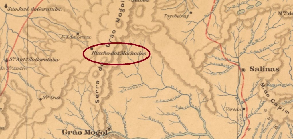
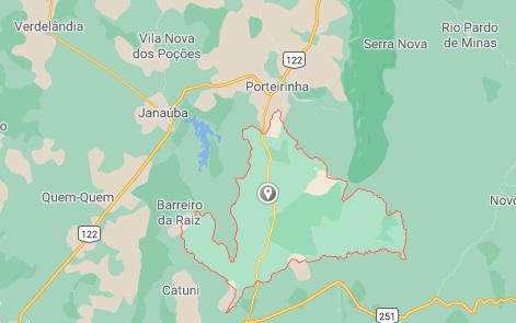
The old locality of Santo Antonio do Riacho dos Machados (= of the Machados’ Brook) was from January 1875 on a district in the municipality of Grão-Mogol, situated over 650 km north of the provincial capital Ouro Preto. In September 1923 it got the name simplified to the actual Riacho dos Machados and went in December 1938 as a district of Porteirinha. Since December 1962 is Riacho dos Machados a municipality.
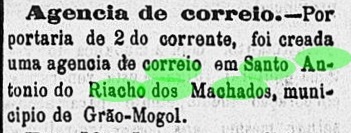
The local post office was created in July 1884, as reported by the regional press:
Liberal Mineiro, July 4, 1884
One imperial cancel has been identified: the only seen example of SMG-3040a (Coll. José A. Junges) until now is not entirely legible, presenting a double circle with the inscription (S.) ANTo. DO RIACHO D(OS MACHADOS) above, dated 1888 at the centre.
GoogleMaps
Anderer Name: Riacho dos Machados (1923)
Die alte Ortschaft Santo Antonio do Riacho dos Machados (= vom Machados’ Bach) war ab Januar 1875 ein Distrikt im Município von Grão-Mogol, der über 650 km nördlich der Provinzhauptstadt Ouro Preto entfernt lag. Im September 1923 bekam er den vereinfachten Namen Riacho dos Machados und ging im Dezember 1938 als ein Distrikt zu Porteirinha über. Seit Dezember 1962 ist Riacho dos Machados ein selbständiger Município.
Das örtliche Postamt wurde im Juli 1884 ins Leben gerufen, wie die Regionalpresse berichtet:
Liberal Mineiro, 4. Juli 1884
Ein Poststempel der Kaiserzeit wurde ermittelt: das bisher einzig gesehene Exemplar von SMG-3040a (Samml. José A. Junges) ist nicht gänzlich lesbar. Es besteht aus einem Doppelkreis mit der Inschrift (S.) ANTo. DO RIACHO D(OS MACHADOS) oben und Datum von 1888 in der Mitte.
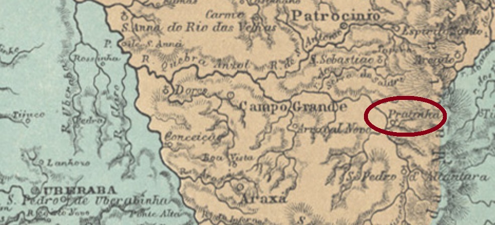
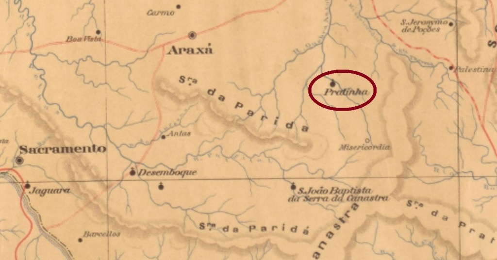
Santo Antonio da Pratinha was since May 1853 a district in the municipality of Araxá, situated almost 400 km west of the provincial capital Ouro Preto. It changed later to two other municipalities, in September 1923 to Ibiá and in December 1943 to Campos Altos, before acquiring the political emancipation in December 1948 under the toponym Pratinha, which was the official name since December 1938.
Paula Sobrinho (História Postal de Minas Gerais, Belo Horizonte, 1997) has recorded two different dates for the creation of the local post office: February 1882 and November 1884. Either the agency had been closed in-between, or one of the dates is wrong. No postal cancel from the Empire has appeared to date.
Mappa de Minas Geraes, 1910
Anderer Name: Pratinha (1938)
Santo Antonio da Pratinha war ab Mai 1853 ein Distrikt im Município von Araxá, der fast 400 km westlich der Provinzhauptstadt Ouro Preto entfernt lag. Später wechselte er zweimal die Zuständigkeit – im September 1923 zu Ibiá und im Dezember 1943 zu Campos Altos – bevor im Dezember 1948 die politische Selbständigkeit erreicht wurde: der neue Município hieß Pratinha, dieser Name war bereits seit Dezember 1938 offiziell.
Paula Sobrinho (História Postal de Minas Gerais, Belo Horizonte, 1997) lieferte zwei verschiedene Daten für die Entstehung des örtlichen Postamts: Februar 1882 and November 1884. Entweder war die Agentur zwischendurch geschlossen oder stimmt eines der Daten nicht. Kein Poststempel der Kaiserzeit war bisher zu sehen.
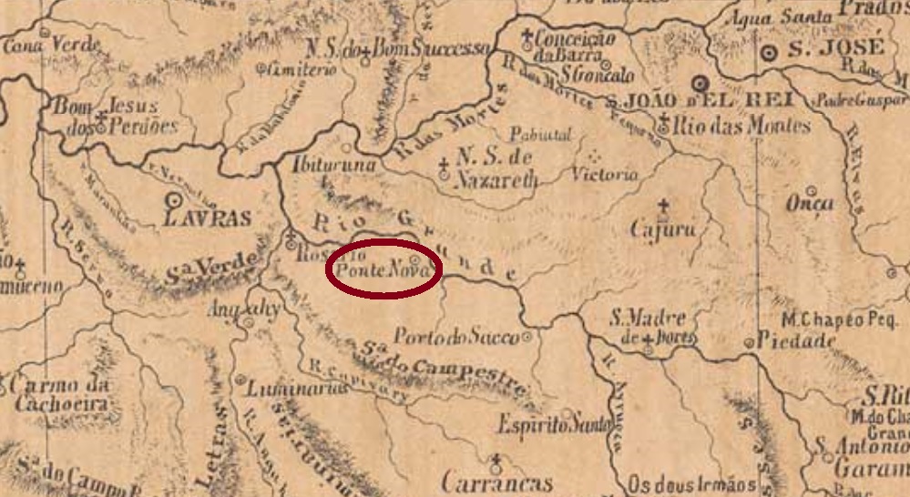
Santo Antonio da Ponte Nova (= of the New Bridge) was since September 1870 a district in the municipality of São João d’El Rey, situated on the Rio Grande, ca. 200 km southwest of the provincial capital Ouro Preto. In November 1880 it changed as a district to Lavras and was called Itutinga from September 1924 on. This tupi word means white waterfall. Itutinga became a district of the municipality of Itumirim in December 1943 and emancipated politically ten years later.
According to Paula Sobrinho (História Postal de Minas Gerais, Belo Horizonte, 1997), the local post office was created in October 1881. One imperial cancel is recorded: SMG-2980a (Coll. Dieter Kerkhoff) has a double circle with the inscription S. ANTONIO DA PONTE NOVA above and a diamond ornament below, formed by four small diamonds. The dates at the centre are from 1888 to 1898.
Mappa de Minas Geraes, 1910
Anderer Name: Itutinga (1924)
Santo Antonio da Ponte Nova (= der Neuen Brücke) war ab September 1870 ein Distrikt im Município von São João d’El Rey, der am Rio Grande lag, ca. 200 km südwestlich der Provinzhauptstadt Ouro Preto. Im November 1880 wechselte er als Distrikt zu Lavras und hieß ab September 1924 Itutinga. Das Wort aus der Tupi-Sprache bedeutet Weißer Wasserfall. Itutinga wurde im Dezember 1943 ein Distrikt im Município von Itumirim und erhielt zehn Jahre später seine politische Selbständigkeit.
Laut Paula Sobrinho (História Postal de Minas Gerais, Belo Horizonte, 1997) gibt es dort ein Postamt seit Oktober 1881. Ein Stempel der Kaiserzeit ist überliefert: SMG-2980a (Samml. Dieter Kerkhoff) hat einen Doppelkreis mit der Inschrift S. ANTONIO DA PONTE NOVA oben und einem Rautenornament unten, das aus vier kleinen Rauten besteht. Die Daten in der Mitte gehen von 1888 bis 1898.
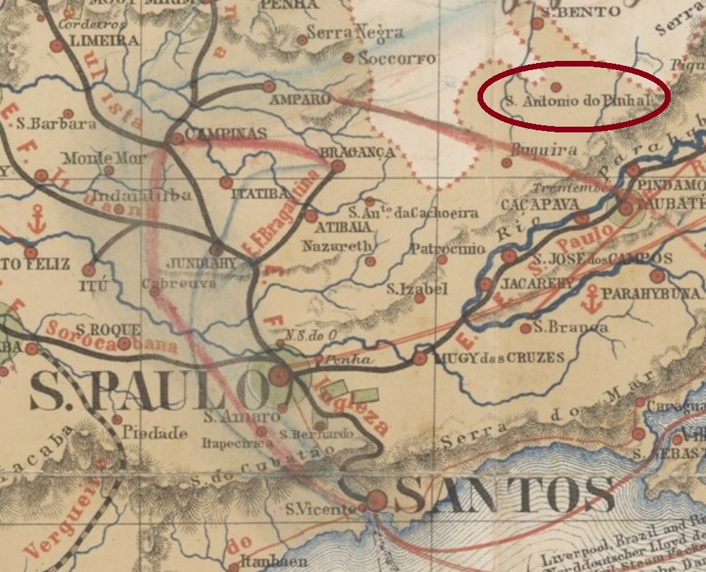
J.M. Ribeiro Lisboa: Mappa da Provincia de São Paulo, 1884
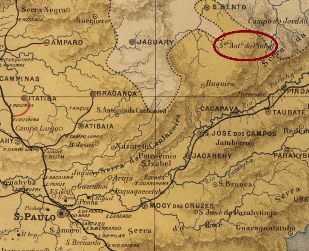
Santo Antonio do Pinhal was since March 1861 a freguesia in the municipality of S. Bento do Sapucahy, situated round 180 km northeast of the province capital São Paulo. In March 1880 it ascended to a district, which became an own municipality in February 1959.
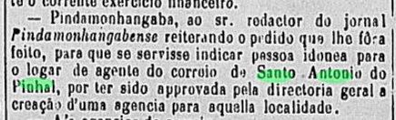
The local post office was created by December 1876, as reported by the regional press:
Correio Paulistano, December 17, 1876
One imperial cancel was found. SSP-1330a (Coll. FM) is a French-type: a double circle with the inscription S. ANTo. DO PINHAL above and the star between parentheses below. The dates at the centre were found for the period 1885-1899.
Provincia de São Paulo, 1886
Santo Antonio do Pinhal war ab März 1861 eine Freguesia im Município von S. Bento do Sapucahy, die rund 180 km nordöstlich der Provinzhauptstadt São Paulo entfernt lag. Im März 1880 stieg sie zum Distrikt auf, der im Februar 1959 ein eigenständiger Município wurde.
Das örtliche Postamt entstand bis zum Dezember 1876, wie die Regionalpresse berichtet:
Correio Paulistano, 17. Dezember 1876
Ein Poststempel der Kaiserzeit wurde gefunden. SSP-1330a (Samml. FM) ist ein „Französischer-Typus“: er hat einen Doppelkreis mit der Inschrift S. ANTo. DO PINHAL oben und den Stern zwischen Klammern unten. Die Daten in der Mitte wurden für den Zeitraum 1885-1899 ermittelt.
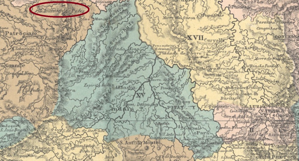
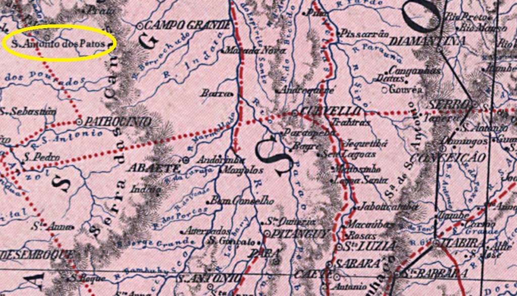
Santo Antonio dos Patos was since May 1850 a parish in the municipality of Patrocínio, situated almost 500 km northwest of the provincial capital Ouro Preto. In October 1866 it ascended to a villa, which was declared the town of Patos in May 1892. Since December 1943 the municipality is called Patos de Minas.
Both R. Koester (Carimbologia XXX) and Paula Sobrinho (História Postal de Minas Gerais, Belo Horizonte, 1997) agree in dating the agency creation in May 1871. No postal cancel of the Empire has been found for this toponym until now. For cancels with only PATOS see R. Koester’s Carimbologia XXX.
Carta da Republica dos Estados Unidos do Brazil, 1892
Anderer Name : Patos de Minas (1943)
Siehe auch Patos/MG (R. Koester : Carimbologia XXX)
Santo Antonio dos Patos war ab Mai 1850 eine Pfarrei im Município von Patrocínio, die fast 500 km nordwestlich der Provinzhauptstadt Ouro Preto entfernt lag. Im Oktober 1866 stieg sie zur Villa, die im Mai 1892 die Stadt Patos wurde. Seit Dezember 1943 heißt dieser Município Patos de Minas.
Sowohl R. Koester (Carimbologia XXX) als auch Paula Sobrinho (História Postal de Minas Gerais, Belo Horizonte, 1997) sind sich einig darüber, dass es dort seit Mai 1871 ein Postamt gibt. Kein Poststempel aus dem Kaiserreich wurde bisher mit diesem Ortsnamen gefunden. Für Stempel mit lediglich PATOS siehe R. Koesters Carimbologia XXX.
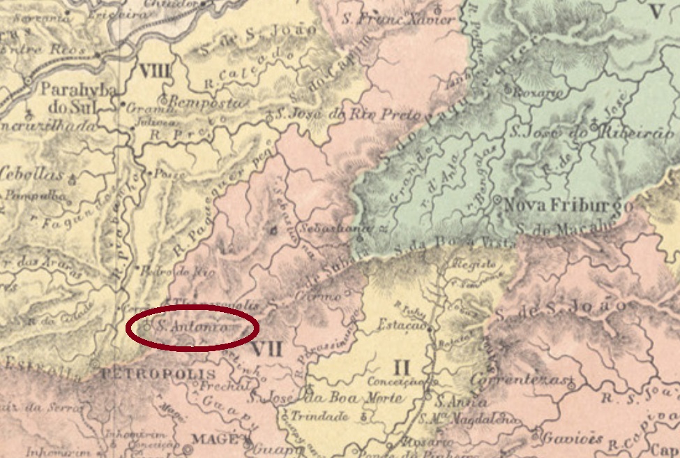
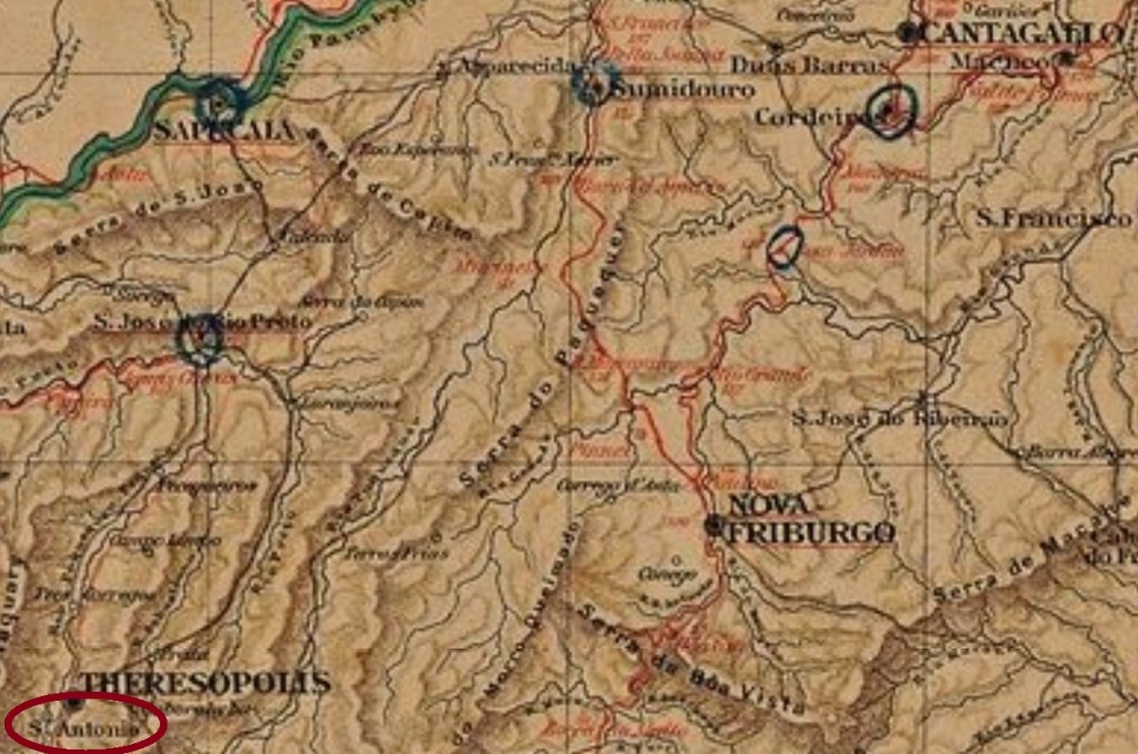
Santo Antonio do Paquequer was since October of 1855 a district of the municipality of Magé, situated round 100 km north of the imperial capital Rio de Janeiro. It ascended to a political independent villa in July 1891, which changed the toponym to Teresópolis in June 1892. The name is a tribute to the empress Teresa Cristina, the wife of D. Pedro II. Since January 1893 is Teresópolis a town.
Although the toponym Teresópolis was made official only in 1892, it is evident that it was used as early as 1859, when a post office under this name was opened in Santo Antonio do Paquequer. Obviously, the future name had been planned in such an advance that the postal administration did not hesitate in applying it beforehand:
Correio da Tarde, November 8, 1859
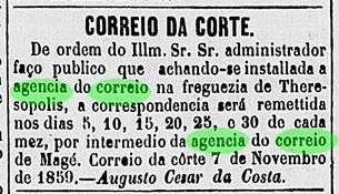
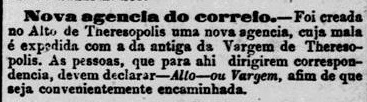
Things got more complicated in July 1862, when according to Paulo Novaes (agenciaspostais.com.br) another agency opened in Santo Antonio do Paquequer. This one closed “ca. 1864” (P. Novaes), but reopened in October 1874, under the name of Alto de Theresopolis, as reported by the Rio press:
Jornal do Commercio, October 3, 1874
Considering that the Theresopolis agency was also operating at that time, there must have been two post offices in the village. The older one, situated in the lower part (Várzea or Vargem), was called Theresopolis from the start in 1859. The later one was situated uphill and must have been the Santo Antonio do Paquequer agency of 1862 that closed two years later and reopened in 1874 under the name Alto (High) de Theresopolis. This can be ratified by the 1880 Postal Guide (Guia Postal do Imperio), which lists offices both in Alto de Theresopolis (#34) and in Theresopolis (#1137).
According to P. Novaes, both agencies are operating still nowadays. No imperial postal cancel from Santo Antonio do Paquequer has appeared until now.
Almanak Laemmert, 1892
Siehe auch Theresopolis
Santo Antonio do Paquequer war ab Oktober 1855 ein Distrikt im Município von Magé, der rund 100 km nördlich der kaiserlichen Hauptstadt Rio de Janeiro entfernt lag. Im Juli 1891 stieg er zur eigenständigen Villa, deren Namen im Juni 1892 zur aktuellen Teresópolis wechselte. Dieser Bezeichnung ist eine Hommage an die Kaiserin Teresa Cristina, die Frau des D. Pedro II. Seit Januar 1893 ist Teresópolis eine Stadt.
Obwohl der Ortsname Teresópolis erst 1892 offiziell wurde, war er offenbar bereits 1859 im Umlauf gewesen, als ein Postamt mit diesem Namen in der Gemeinde öffnete. Daraus geht hervor, dass der künftige Ortsname sehr lange im Voraus geplant war, und die Postverwaltung dadurch keine Probleme mit der frühen Verwendung hatte:
Correio da Tarde, 8. November 1859
Die Lage wurde aber im Juli 1862 komplizierter, als laut Paulo Novaes (agenciaspostais.com.br) ein anderes Postamt im Santo Antonio do Paquequer eröffnete. Dieses schloss “ca. 1864” (P. Novaes) wieder ab, um im Oktober 1874 abermals zu öffnen, nun unter dem Namen Alto de Theresopolis, wie die Rio-Presse berichtet:
Jornal do Commercio, 3. Oktober 1874
Da die Postagentur Theresopolis in der Zeit auch in Betrieb war, gab es wohl damals zwei Postämter in der Ortschaft. Das Ältere lag im unteren Ortsteil (Várzea oder Vargem) und hieß Theresopolis vom Betriebsbeginn 1859 an. Das Spätere lag im oberen Ortsteil und muss das Postamt Santo Antonio do Paquequer von 1862 sein, das zwei Jahre später geschlossen wurde und erst 1874 unter dem Namen Alto (Ober-) de Theresopolis wieder öffnete. Das kann durch den Postführer von 1880 (Guia Postal do Imperio) bestätigt werden, der beide Agenturen auflistet: Alto de Theresopolis (Nr. 34) und Theresopolis (Nr. 1137).
Beide Postämter sind heute noch im Betrieb, wie P. Novaes schreibt. Kein Poststempel aus der Kaiserzeit von Santo Antonio do Paquequer war bisher zu sehen.
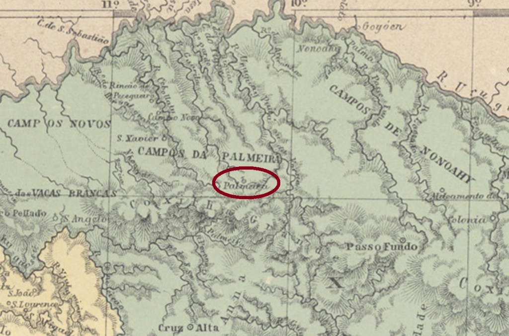
Other names: Vilinha de Palmeira, Palmeira, Palmeira das Missões (1944)
A former district of the municipality of Cruz Alta, Santo Antonio da Palmeira was situated almost 400 km northwest of the province capital Porto Alegre. It emancipated politically in May 1874 under the name of Palmeira, which changed to the actual Palmeira das Missões in December 1944.
According to the Province President Report for 1879, the local post office startet operations in August 1878:
Relatório do Presidente da Provincia/RS, 1879
No postal cancel of the Empire has been found with this toponym until now.
Provincia de São Pedro, 1877
Andere Namen: Vilinha de Palmeira, Palmeira, Palmeira das Missões (1944)
Santo Antonio da Palmeira war ein ehemaliger Distrikt von Cruz Alta, der fast 400 km nordwestlich der Provinzhauptstadt Porto Alegre entfernt lag. Im Mai 1874 erhielt er seine politische Selbständigkeit als Município unter den Ortsnamen Palmeira. Dieser wechselte im Dezember 1944 zum aktuellen Palmeira das Missões.
Laut dem Bericht des Provinzpräsidenten für 1879 startete der Betrieb des örtlichen Postamts im August 1878:
Relatório do Presidente da Provincia/RS, 1879
Kein Poststempel des Kaiserreichs unter diesem Ortsnamen konnte bisher gefunden werden.
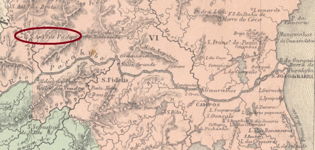
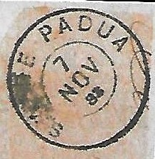
The freguesia of Santo Antonio de Padua was founded in June 1843 on the Pomba River, municipality of São Fidellis, round 250 km northeast of the imperial capital Rio de Janeiro. In January 1882 it ascended to a villa in own municipality and became a town in December 1889.
It was followed by SRJ-0900b (image from the internet): a double circle with the inscription S. A. DE PADUA above and a ( I ) below. The dates at the centre were found for the period 1884-1885. SRJ-0900c (Coll. José A. Junges) was in circulation between 1885 and 1887. Here the inscription between the circles is S. ANTONIO DE PADÚA (with a curious wrong accent upon the U), and the ornament below is now a diamond formed by four small diamonds. Dates at the centre. SRJ-0900d (Coll. Paulo Novaes) is the last imperial cancel, with central dates between 1889 and 1894. The inscription between circles is now corrected to S. ANTONIO DE PADUA, but here the inferior ornament is an X.
After the release of Carimbologia S1 another cancel was found: SRJ-0900e (Coll. Paulo Novaes) has a double circle with the inscription S. A. DE PADUA above. The dates inside vary from 1883 to 1885.
SRJ-0900e (agenciaspostais.com.br)
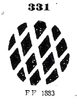
The local mute cancellation has accompanied quite often SRJ-0900a between ca. 1866 and at least 1883, its image was also depicted by Paulo Ayres (op. cit.) under # 331:
P.Ayres #331Villiers de l’Ile Adam: Carta (…) da Provincia do Rio de Janeiro, 1850
Aktualisierung der Buchausgabe, am 15. Mai 2021
Die Freguesia von Santo Antonio de Padua wurde im Juni 1843 am Fluss Pomba im Município von São Fidellis gegründet und lag rund 250 km nordöstlich der kaiserlichen Hauptstadt Rio de Janeiro. Im Januar 1882 stieg sie zur eigenständigen Villa auf und wurde zur Stadt im Dezember 1889 erklärt.
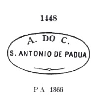
Laut Nova Monteiro (Administrações e Agencias Postaes do Brasil Imperio, in Brasil Filatelico/RJ, 1934-5; Reprint SPP 1994-1999) entstand das örtliche Postamt im Februar 1855. Fünf Ortsstempel und ein “Stummer” wurden bisher gefunden. Der früheste davon, SRJ-0900a, wurde wohl von Anfang an bis zumindest 1866 verwendet und war bereits durch Paulo Ayres in seinem Catálogo de Carimbos Brasil-Império (S. Paulo, 1937, 1942) unter Nr. 1448 bekannt gemacht:
SRJ-0900a (P. Ayres #1448)
Ihm folgte SRJ-0900b (Abb. aus dem Internet): ein Doppelkreis mit der Inschrift S. A. DE PADUA oben und einem ( I ) unten. Die Daten in der Mitte wurden für den Zeitraum 1884-1885 gefunden. SRJ-0900c (Samml. José A. Junges) wurde zwischen 1885 und 1887 verwendet. Hier lautet die Inschrift zwischen den Kreisen S. ANTONIO DE PADÚA (mit einem merkwürdigen falschen Akzent auf dem U), und das untere Ornament ist nun eine Raute, die aus vier kleinen Rauten besteht. Daten in der Mitte. SRJ-0900d (Samml. Paulo Novaes) ist der letzte Stempel der Kaiserzeit, die inneren Daten gehen von 1889 bis 1894. Die Inschrift zwischen den Kreisen ist nun zu S. ANTONIO DE PADUA korrigiert, und das untere Ornament ist ein X.
Nach dem Erscheinen von Carimbologia S1 ein weiterer Ortsstempel wurde gefunden: SRJ-0900e (Samml. Paulo Novaes) hat einen Doppelkreis mit der Inschrift S. A. DE PADUA oben. Die Daten im Inneren gehen von 1883 bis 1885.
SRJ-0900e (agenciaspostais.com.br)
Die stumme Abstempelung begleitete oft SRJ-0900a zwischen ca. 1866 und zumindest 1883; deren Abbildung lieferte ebenfalls Paulo Ayres (op. cit.), unter Nr. 331:
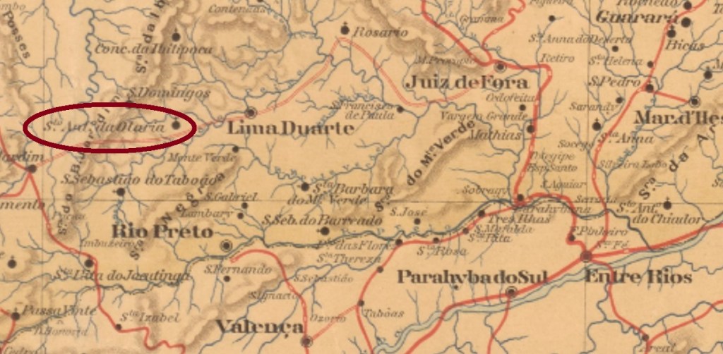
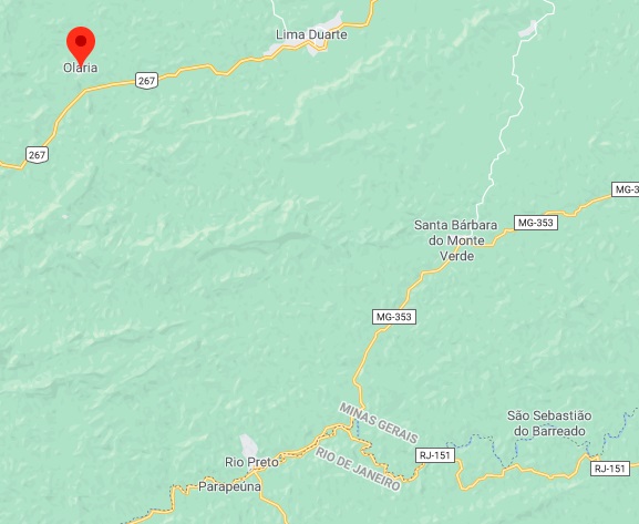
Santo Antonio da Olaria (= St. Anthony of the Brickworks) was since July 1872 a district in the municipality of Rio Preto, situated ca. 230 km south of the provincial capital Ouro Preto. In September 1923 it switched to the newly created municipality of Lima Duarte and had the name simplified to Olaria in December 1938. Since December 1962 has Olaria an own municipality.
According to Paula Sobrinho (História Postal de Minas Gerais, Belo Horizonte, 1997), the local post office was created in March 1885. One imperial cancel was found. SMG-2975a (Coll. Karlheinz Wittig) occurs in black and blue and has a double circle with the inscriptions S. ANTo. DA OLARIA above and (MINAS) below. Dates at the centre between 1889 and 1895.
GoogleMaps
Anderer Name: Olaria (1938)
Santo Antonio da Olaria (= Hl. Antonius der Ziegelei) war ab Juli 1872 ein Distrikt im Município von Rio Preto, der ca. 230 km südlich der Provinzhauptstadt Ouro Preto lag. Im September 1923 wechselte der Ort zum frisch gegründeten Município von Lima Duarte und bekam im Dezember 1938 den Namen zu Olaria vereinfacht. Seit Dezember 1962 ist Olaria eine eigenständige Gemeinde.
Wie Paula Sobrinho (História Postal de Minas Gerais, Belo Horizonte, 1997) schreibt, gibt es dort ein Postamt seit März 1885. Ein Stempel des Kaiserreichs wurde gefunden. SMG-2975a (Samml. Karlheinz Wittig) kommt in schwarz und blau vor und hat einen Doppelkreis mit den Inschriften S. ANTo. DA OLARIA oben sowie (MINAS) unten. Die Daten in der Mitte entstammen dem Zeitraum 1889-1895.
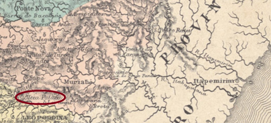
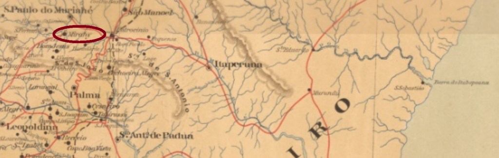
A pataca was an old Brazilian silver coin, about 320 réis worth. So had a Meia Pataca (half pataca) the approximate value of 160 réis. The freguesia of Meia Pataca was founded in June 1859 near the west bank of the Muriaé River in the municipality of Cataguazes, round 180 km southeast of the province capital Ouro Preto. The locality was given in October 1883 the name of Santo Antonio do Muriahé, but barely 20 years later it was renamed Mirahy and became an own municipality in September 1923. This tupi word shall mean swamp.
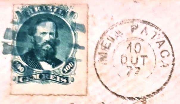
According to Paula Sobrinho (História Postal de Minas Gerais, Belo Horizonte, 1997), the local post office was created in October 1881. In the meantime, however, a letter dated October 1877 has turned up with the philatelist Constantino Papazoglu, bearing both a postmark with MEIA PATACA and a mute postmark:
1877 (Papazoglu)
This post office therefore had an earlier period of operation, the dates of which have yet to be discovered. Two later postmarks are already known: SMG-3005a (Coll. José A. Junges) has a double circle with the inscription S. ANTONIO DO MURIAHÉ above and a diamond ornament below, formed by four small diamonds. Dates at the centre from 1885-1886. SMG-3005b (Coll. José A. Junges) has between both circles the inscriptions S. ANTo. DE MURIAHÉ above and (MINAS) below. Dates at the centre between 1891 and 1894.
Mappa de Minas Geraes, 1910
Textaktualisierung am 27. Juli 2023
Andere Namen: Meia Pataca (1859), Mirahy (1903)
Eine Pataca war eine alte brasilianische Silbermünze, etwa 320 Réis wert. Dadurch schlug eine Meia Pataca (halbe Pataca) mit ca. 160 Réis zu Buche. Die Freguesia von Meia Pataca wurde im Juni 1859 nah am Westufer des Flusses Muriaé im Município von Cataguazes gegründet und lag knapp 180 km südöstlich der Provinzhauptstadt Ouro Preto entfernt. Die Ortschaft bekam im Oktober 1883 den zivilisierten Namen Santo Antonio do Muriahé. Dieser durfte aber nicht sehr beliebt gewesen sein, da der Ort knapp 20 Jahre später zu Mirahy umbenannt wurde. Das Tupi-Wort bedeutet Sumpf, und Mirahy ist seit September 1923 ein selbständiger Município.
Laut Paula Sobrinho (História Postal de Minas Gerais, Belo Horizonte, 1997) gibt es dort ein Postamt seit Oktober 1881. Inzwischen ist jedoch ein Brief vom Oktober 1877 bei dem Philatelisten Constantino Papazoglu aufgetaucht, der sowohl einen Poststempel mit MEIA PATACA als auch einen stummen Stempel trägt:
1877 (Papazoglu)
Dieses Postamt hatte also eine frühere Betriebsperiode, deren Daten noch zu entdecken sind. Zwei spätere Poststempel sind bereits bekannt:
SMG-3005a (Samml. José A. Junges) hat einen Doppelkreis mit der Inschrift S. ANTONIO DO MURIAHÉ oben und einem Ornament in Rautenform unten, das aus vier kleinen Rauten besteht. Daten in der Mitte aus dem Zeitraum 1885-1886. SMG-3005b (Samml. José A. Junges) hat zwischen den Kreisen die Inschriften S. ANTo. DE MURIAHÉ oben und (MINAS) unten. Die inneren Daten stammen von 1891 bis 1894.