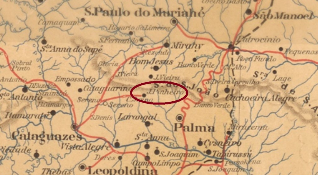
This Sant’Anna was since October 1880 a district of the municipality of Cataguazes (today written Cataguases), situated over 200 km southeast of the province capital Ouro Preto. In 1895 a train station was built unter the name João Pinheiro. In December 1962 the locality was granted an own municipality.
According to Paula Sobrinho (História Postal de Minas Gerais, Belo Horizonte, 1997), the local post office was created in March 1885. The only known post cancel from the Empire, SMG-2710a (Coll. José A. Junges), has a double circle with the inscriptions S.ANNA DE CATAGUAZES above and (MINAS) below. The dates at the centre were found for the period 1888-1900.
Raphael Lorenzeto de Abreu (CC- BY 2.5)
Diese Sant’Anna war seit Oktober 1880 ein Distrikt im Município von Cataguazes (heute Cataguases geschrieben) und lag über 200 km südöstlich der ehemaligen Provinzhauptstadt Ouro Preto entfernt. Der dazu gehörige Bahnhof – gebaut 1895 – hieß João Pinheiro. Im Dezember 1962 stieg die Ortschaft zum Município auf.
Laut Paula Sobrinho (História Postal de Minas Gerais, Belo Horizonte, 1997) entstand das örtliche Postamt im März 1885. Der bisher einzige Poststempel aus der Kaiserzeit, SMG-2710a (Samml. José A. Junges), hat einen Doppelkreis mit den Inschriften S.ANNA DE CATAGUAZES oben und (MINAS) unten. Die Daten in der Mitte wurden für den Zeitraum 1888-1900 gefunden.
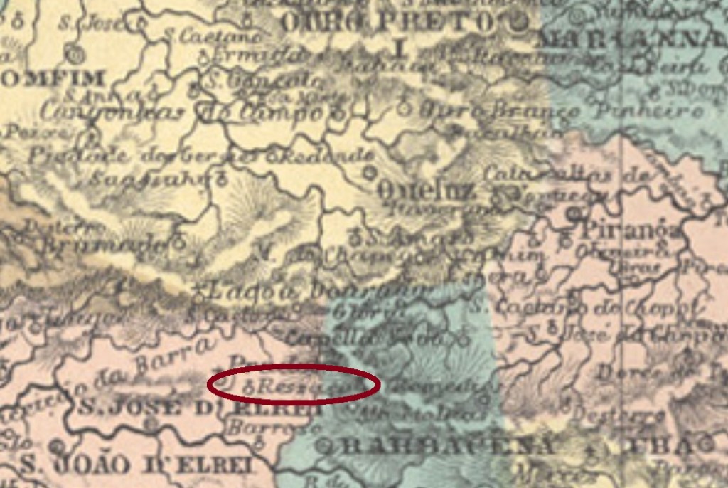
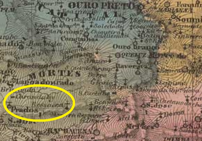
This Sant’Anna in the Minas Gerais province was since July 1872 the freguesia of Sant’Anna da Ressaca do Carandahy, in the municipality of Barbacena, situated almost 100 km south of the province capital Ouro Preto. In July 1876 it was transferred to the municipality of São José del Rey (the actual Tiradentes) and emancipated politically in September 1923 under the simplified toponym of Carandaí.
Both Reinhold Koester (Carimbologia IX) and Paula Sobrinho (História Postal de Minas Gerais, Belo Horizonte, 1997) agree in setting the creation date of the local post office in May 1875. This would mean there might exist postal cancellations still with the legend Sant’Anna da Ressaca or Sant’Anna do Carandahy. Nevertheless, none of them has appeared until now. For cancels with solely Carandahy, which occur from ca. 1885 on, see Koester’s Carimbologia IX.
Villiers de l’Ile Adam: Charta (…) da Provincia de Minas Geraes, 1849
Anderer Name: Sant’Anna da Ressaca
Siehe auch: Carandahy (Koester: Carimbologia IX)
Diese Sant’Anna in der Provinz Minas Gerais war ab Juli 1872 die Freguesia von Sant’Anna da Ressaca do Carandahy im Município von of Barbacena und lag fast 100 km südlich der Provinzhauptstadt Ouro Preto entfernt. Im Juli 1876 wechselte sie zum Município von São José del Rey (heute: Tiradentes) und erhielt ihre politische Autonomie im September 1923 unter dem vereinfachten Ortsnamen Carandaí.
Sowohl Reinhold Koester (Carimbologia IX) als auch Paula Sobrinho (História Postal de Minas Gerais, Belo Horizonte, 1997) sind sich einig über das Entstehungsdatum des örtlichen Postamts im Mai 1875. Das würde bedeuten, es müsste noch Poststempel mit Sant’Anna da Ressaca, oder Sant’Anna de Carandahy geben. Dennoch war bisher keine davon zu sehen. Für Stempel mit lediglich Carandahy – die es ab ca. 1885 gibt – siehe Koesters Carimbologia IX.
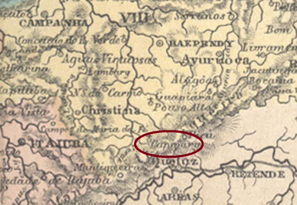
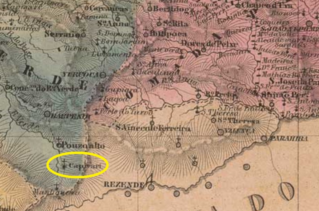
This Sant’Anna in provincial Minas Gerais was since December 1874 a district of the municipality of Pouso Alto, situated over 350 km southwest of the capital Ouro Preto and whose political status has remained until our days, with remarkable steadiness. The Capivary in the name is a tupi-guarani word that means Capybara River and refers to the upper course of the river around which this mammal must have been abundant.
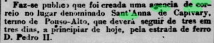
According to Paula Sobrinho (História Postal de Minas Gerais, Belo Horizonte, 1997), the local post office was created in October 1889, but this is either a reopening date or a misprint, for there exist some cancels with earlier dates. Moreover, the local post office was announced by the Rio press as early as July 1877:
Jornal do Commercio, Rio de Janeiro, July 10, 1877
Two early cancels were found. SMG-2740a (Coll. José A. Junges) has a double circle with the inscription SANT’ANNA DE CAPIVARY above and a hashtag-like ornament below. The dates at the centre indicate the period 1879-1885. SMG-2740b (Coll. José A. Junges) can be already republican, for the sole known example is dated 1895: a double circle with the inscription SANT’ANNA DE CAPIVARY above and a diamond ornament below. Date at the centre.
Villiers de l’Ile Adam: Charta (…) da Provincia de Minas Geraes, 1849
Diese Sant’Anna in der Provinz Minas Gerais war seit Dezember 1874 ein Distrikt im Município von Pouso Alto, lag über 350 km südwestlich der Hauptstadt Ouro Preto und behielt mit bemerkenswerter Beständigkeit den Verwaltungsstatus bis heute. Das im Ortsnamen erwähnte Capivary ist ein Wort der tupi-guarani-Sprache, das Fluss der Capybaras bedeutet und darauf hinweist, dass im Flussoberlauf damals diese Säugetiere oft anzutreffen waren.
Laut Paula Sobrinho (História Postal de Minas Gerais, Belo Horizonte, 1997) entstand das örtliche Postamt im Oktober 1889, aber das ist entweder ein Wiedereröffnungsdatum oder einfach ein Druckfehler. Denn erstens sind Poststempel aus früheren Daten vorhanden, und zweitens wurde die Agentur bereits im Juli 1877 durch die Rio-Presse angekündigt:
Jornal do Commercio, Rio de Janeiro, 10. Juli 1877
Zwei frühe Poststempel wurden gefunden. SMG-2740a (Samml. José A. Junges) hat einen Doppelkreis mit der Inschrift SANT’ANNA DE CAPIVARY oben und einem Hashtag-ähnlichen Ornament unten. Die Daten in der Mitte weisen auf den Zeitraum 1879-1885 hin. SMG-2740b (Samml. José A. Junges) kann bereits republikanisch sein, da das einzige bekannte Exemplar mit 1895 datiert ist: ein Doppelkreis mit der Inschrift SANT’ANNA DE CAPIVARY oben und einer Raute unten, dazu Datum in der Mitte.
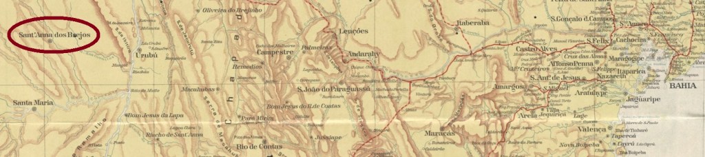
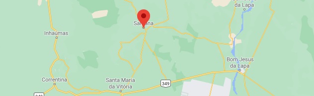
Sant’Anna dos Brejos was since May 1868 a district in the municipality of Santa Maria da Victoria, situated over 800 km west of the province capital Salvador da Bahia. In August 1890 it ascended to a villa, which became a town in April 1901. Since June 1931 this municipality is simply called Santana.
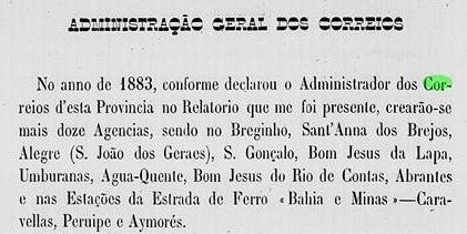
According to the Bahia Provisory Government Council Report for 1884, the local post office was created the year before:
Relatorio do Conselho Interino do Governo da Bahia, 1884
No imperial postmark has appeared until now.
Google Maps
Sant’Anna dos Brejos war seit Mai 1868 ein Distrikt im Município von Santa Maria da Victoria, der über 800 km westlich der Provinzhauptstadt Salvador da Bahia entfernt lag. Im August 1890 stieg er zu einer Villa auf, die im April 1901 eine Stadt wurde. Seit Juni 1931 trägt der Município den vereinfachten Namen Santana.
Laut dem Bericht des provisorischen Regierungsrats in Bahia für 1884 entstand das örtliche Postamt im Jahr zuvor:
Relatorio do Conselho Interino do Governo da Bahia, 1884
Kein Poststempel der Kaiserzeit konnte bisher gefunden werden.
Other names: Santonópole, Roquelândia, Santana do Cariri
This Sant’Anna in Ceará is not the Sant’Anna do Acaraú (SCE-0310), but rather the former district of the municipality of Assaré, founded in August 1838 and situated over 500 km south of the province capital Fortaleza, near the Pernambuco border. In November 1885 it ascended to a villa, whose name changed in August 1896 to Santana de Cariri, a name which would still change twice (in December 1938 to Santonópole and in August 1963 to Roquelândia), and also return twice (in November 1951 and finally in December 1965).
No postal cancel from the Empire has appeared until now.
Villiers de l’Ile Adam: Carta (…) da Provincia do Ceara, 1849
Andere Namen: Santonópole, Roquelândia, Santana do Cariri
Diese Sant’Anna in der Provinz Ceará ist nicht die Sant’Anna do Acaraú (SCE-0310), sondern der ehemaliger Distrikt des Município von Assaré, der im August 1838 gegründet wurde und über 500 km weit südlich der Provinzhauptstadt Fortaleza lag, nah an der Grenze zu Pernambuco. Im November 1885 stieg er zur Villa auf, deren Name im August 1896 zu Santana de Cariri wechselte. Diese Bezeichnung würde danach zweimal geändert (im Dezember 1938 zu Santonópole und im August 1963 zu Roquelândia), um dann zweimal wieder zurück zu kehren (im November 1951 und schließlich im Dezember 1965).
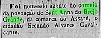
Da dieses Postamt nicht im Verzeichnis der kaiserlichen Postämter (Tabella das Agencias do Correio do Imperio) von 1885 aufgelistet wurde, muss es doch kurz nach dessen Redaktionsschluss entstanden sein, da im Juli 1885 sein Postangestellter in der Regionalpresse vorgestellt wurde:
Gazeta do Norte, 7. Juli 1885
Kein Poststempel aus der Kaiserzeit ist bisher aufgetaucht.
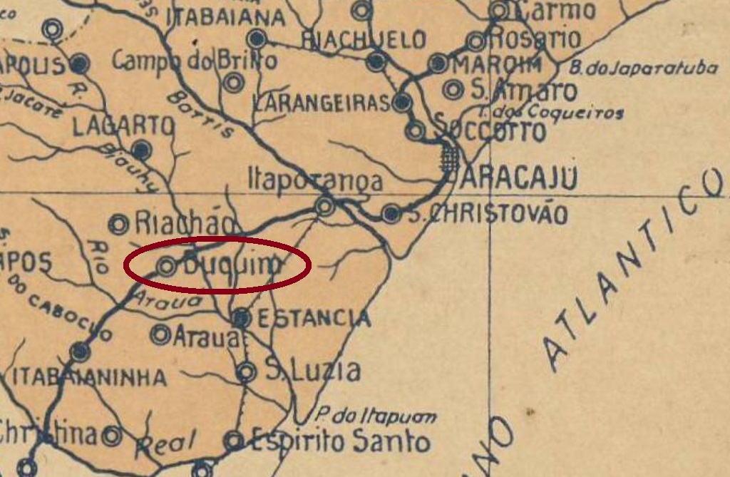
Arthur D. Ribeiro: Mappa do Estado de Sergipe, 1924
Another name: Buquim/Boquim
See also Buquim (Koester: Carimbologia VI) and Lagoa Vermelha/SE (Koester: Carimbologia XXVI)
Sant’Anna do Boquim was the name of the village created in March 1870 after the relocation of Lagoa Vermelha, whose history was already told by Koester (Carimbologia VI and XXVI). The name Boquim is allegedly derivated from Boquinha da Mata (Little mouth of the forest) and refers to the woods that existed in this region, situated almost 90 km southwest of the province capital Aracaju. In October 1926 it emancipated politically and ascended to a town.
According to the Imperial Mail Register (Tabella das Agencias do Correio do Imperio) of 1885, the local post office was created in 1862. But since this year refers to the Lagoa Vermelha agency, we may suppose that the postal services were not interrupted during the village removal in 1870. No postal cancel from the Empire has appeared until now.
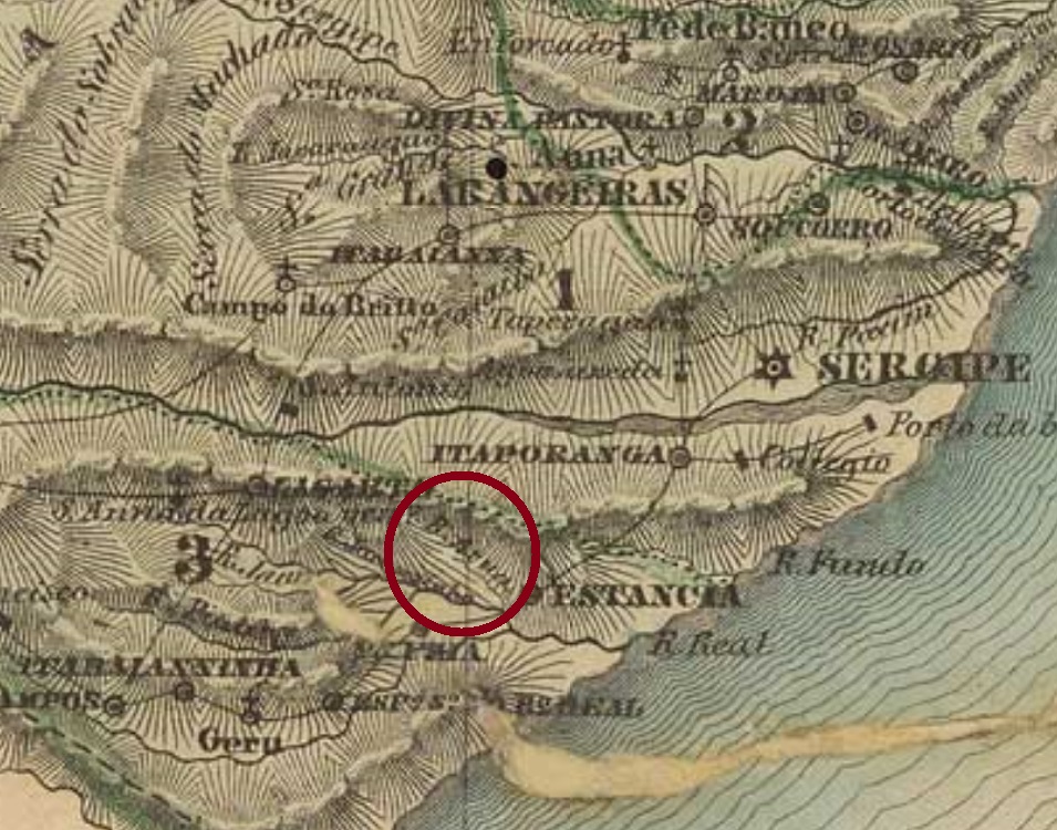
Villiers de L’Ile Adam: Carta (…) das Provincias de Pernambuco, Alagoas e Sergipe, 1848
Anderer Name: Buquim/Boquim
Siehe auch Buquim (Koester: Carimbologia VI) und Lagoa Vermelha/SE (Koester: Carimbologia XXVI)
Sant’Anna do Boquim hieß das Dorf, das im März 1870 nach der Umsiedlung von Lagoa Vermelha gegründet wurde, dessen Geschichte bereits von R. Koester (Carimbologia VI und XXVI) erzählt wurde. Der Name Boquim stammt angeblich von Boquinha da Mata (Kleine Waldeingang) und bezieht sich auf die Wälder der Region, die fast 90 km südwestlich von der Provinzhauptstadt Aracaju entfernt lag. Im Oktober 1926 wurde Boquim als Stadt politisch emanzipiert.
Laut Verzeichnis der kaiserlichen Postämter (Tabella das Agencias do Correio do Imperio) von 1885 entstand 1862 das örtliche Postamt. Da aber der Ort zu der Zeit noch Lagoa Vermelha hieß und woanders lag, können wir annehmen, dass die Postdienste durch den Umzug nicht unterbrochen wurden. Kein Stempel aus der Kaiserzeit wurde bisher gesichtet.
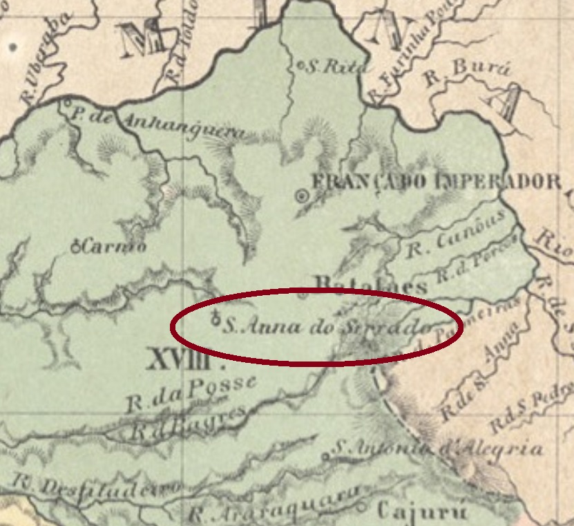
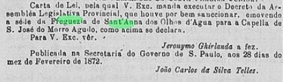
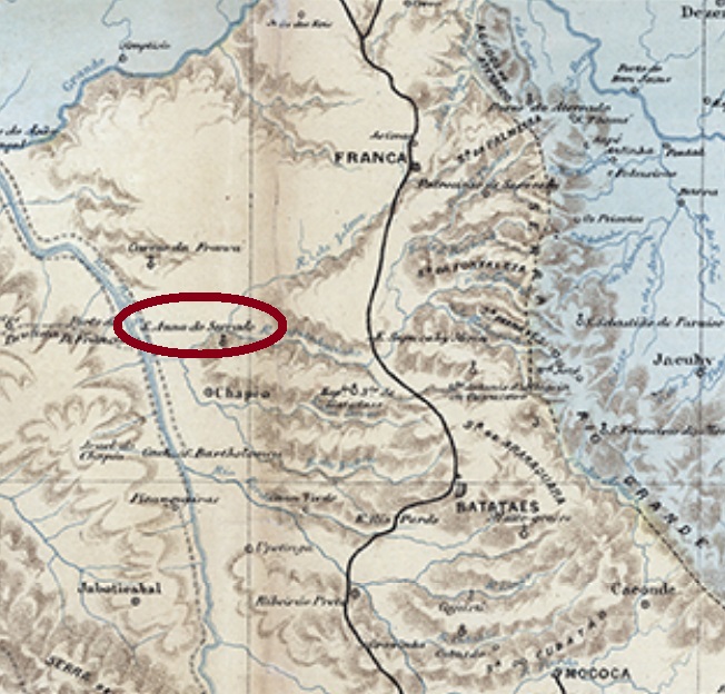
Sant’Anna de Batataes was an alias name to Sant’Anna dos Olhos d’Água, which was since April 1859 a freguesia of the municipality of Batataes, situated between the Sapucahy-Mirim and the Ipuã Rivers, over 400 km north of the provincial capital São Paulo. The detailed history of the village development until becoming Ipuã in 1944 will be described under Sant’Anna dos Olhos d’Água (SSP-1900). It is here important to point to the fact that in February 1872 the freguesia headquerters were transferred to São José do Morro Agudo:
Diario de São Paulo, June 2, 1872
Possibly as a compensation, three years later there was a mail route passing through the village of Sant’Anna de Batataes:
Correio Paulistano, August 21, 1875
Given that all other stops throughout this route had their own post offices, we can assume that at that time a post agency had been created under the toponym Sant’Anna de Batataes. This route was republished regularly in the São Paulo press until November 1877. After that, Sant’Anna de Batateas was not mentioned anymore, and the post office reopened only in January 1887, under Sant’Anna dos Olhos d‘Água. No imperial post cancel has appeared until now.
C. Rath: Mappa da Provincia de São Paulo, 1886
Andere Namen: Sant’Anna do Serrado, Ipuã (1944)
Siehe auch Sant’Anna dos Olhos d’Água (SSP-1900)
Sant’Anna de Batataes war eine andere Bezeichnung für die Ortschaft Sant’Anna dos Olhos d’Água, die seit April 1859 eine Freguesia im Município von Batataes war, und zwischen den Flüssen Sapucahy-Mirim und Ipuã, über 400 km nördlich der Provinzhauptstadt São Paulo entfernt lag. Die detaillierte Ortsgeschichte bis Ipuã (1944) wird unter Sant’Anna dos Olhos d’Água (SSP-1900) erzählt. Hier ist es aber wichtig zu betonen, dass im Februar 1872 der Hauptsitz der Freguesia nach São José do Morro Agudo verlegt wurde:
Diario de São Paulo, 2. Juni 1872
Möglicherweise als Kompensation dafür angedacht, wurde drei Jahre später in der Regionalpresse eine Postroute angekündigt, die durch den Ort Sant’Anna de Batataes fuhr:
Correio Paulistano, 21. August 1875
Da alle andere Haltestellen der Route ihre eigenen Postämter hatten, können wir davon ausgehen, dass zu diesem Zeitpunkt auch in Sant’Anna de Batataes eine Agentur existierte. Diese Route war fortan regelmäßig bis November 1877 in der Paulista-Presse zu lesen. Danach wurde Sant’Anna de Batataes nicht mehr erwähnt, und erst im Januar 1887 eröffnete ein Postamt – unter dem Ortsnamen Sant’Anna dos Olhos d’Água – wieder. Keine postalische Abstempelung von Sant’Anna de Batataes war bisher zu sehen.
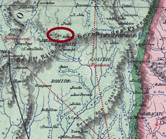
Other names: Sant’Anna d’Antas, Sant’Anna de Campos Ricos, Anápolis (1907)
Anta is the portuguese name for the South American tapir (Tapirus terrestris, Linnaeus, 1758), that must have been very common in the region, because it has named both the Rio das Antas and this locality. Formerly the district of Sant’Anna de Campos Ricos, it was created in June 1873 and belonged to the municipality of Meia Ponte (today: Pirenópolis), situated almost 200 km east of the former province capital Goyaz. In September 1887 it was elevated to the Villa of Sant’Anna das Antas, twenty years later the toponym changed to the actual Anápolis.
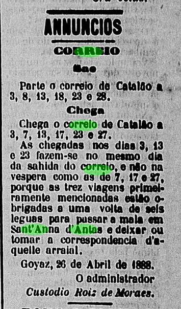
The local post office opened apparently by April 1888, since a press note announces a change in the regional mail route in order to serve this locality from then on:
Goyaz, April 27, 1888
One imperial cancel is known: SGO-0200a (Coll. Fuad Ferreira Fo.) has a double circle with the inscriptions S. ANNA DAS ANTAS above and (GOYAZ) below. The only found example is dated 1889 at the centre.
Carta da Republica dos Estados Unidos do Brazil, 1892
Andere Namen: Sant’Anna d’Antas, Sant’Anna de Campos Ricos, Anápolis (1907)
Anta ist das portugiesische Wort für den Südamerikanischen Tapir (Tapirus terrestris, Linnaeus, 1758), der in dieser Gegend sehr geläufig sein mußte, denn er gab seinen Namen sowohl dem Rio das Antas als auch diesem Ort. Dieser wurde im Juni 1873 als der Distrikt von Sant’Anna de Campos Ricos im Município von Meia Ponte (today: Pirenópolis) gegründet und lag fast 200 km östlich der ehemaligen Provinzhauptstadt Goyaz entfernt. Im September 1887 stieg er zur Villa von Sant’Anna das Antas auf, zwanzig Jahre später wechselte der Ortsname zum heutigen Anápolis.
Das örtliche Postamt eröffnete offenbar kurz vor April 1888, da eine Pressenotiz zu diesem Zeitpunkt einen Wechsel in der Postroute ankündigte, eben um diese Ortschaft fortan zu bedienen:
Goyaz, 27. April 1888
Ein Stempel der Kaiserzeit ist überliefert: SGO-0200a (Samml. Fuad Ferreira Fo.) hat einen Doppelkreis mit den Inschriften S. ANNA DAS ANTAS oben und (GOYAZ) unten. Das einzige gefundene Exemplar trägt ein Datum aus 1889 in der Mitte.
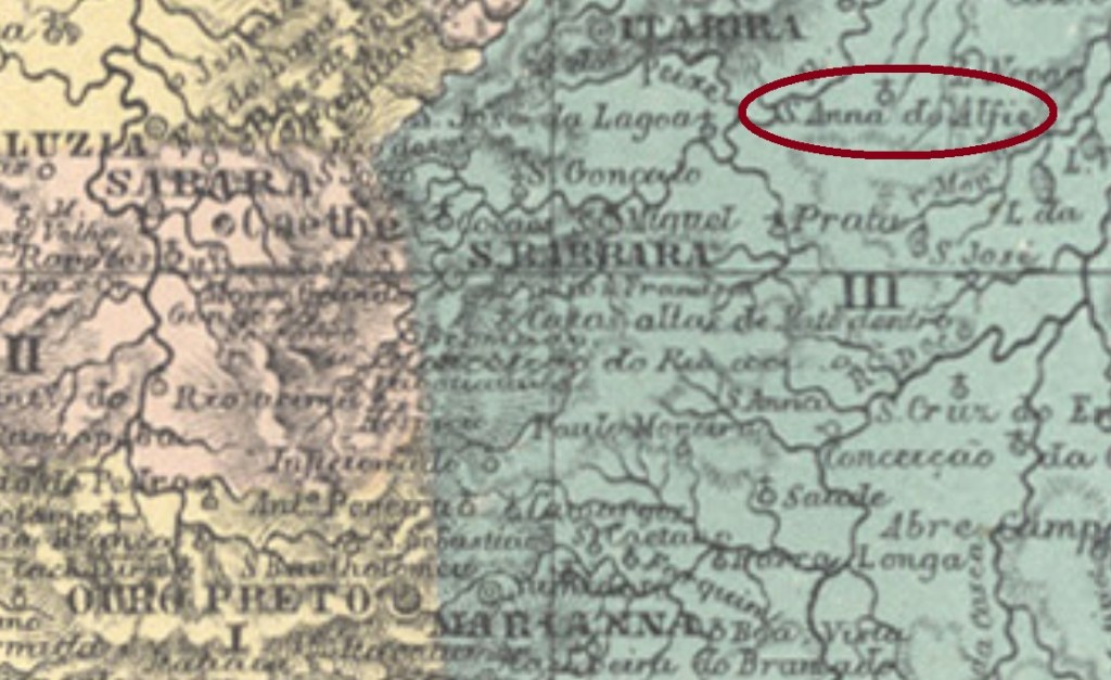
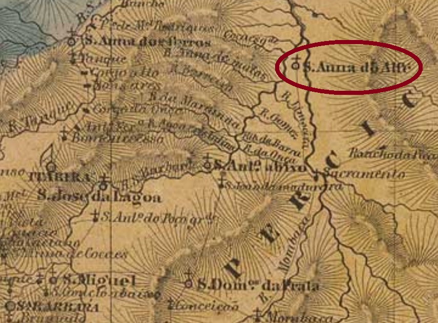
Sant’Anna do Alfié (or simply Alfié) was since April 1840 a district of the municipality of Santa Barbara, situated over 150 km northeast of the provincial capital Ouro Preto. In March 1890 it changed as a district of the newly founded municipality of São Domingos do Prata and has remained so until our days.
According to Paula Sobrinho (História Postal de Minas Gerais, Belo Horizonte, 1997), the local post office was created in March 1877. The only imperial cancel known to date is SMG-2735a (image from the internet): a double circle with the inscription SANT’ANNA DO ALFIÉ above and a diamond ornament below, which consists of four small diamonds. Dates at the centre come from the period 1886-1895.
Villiers de l’Ile Adam: Carta (…) da Provincia de Minas Geraes, 1849
Sant’Anna do Alfié (oder einfach Alfié) war seit April 1840 ein Distrikt des Município von Santa Barbara und lag über 150 km nordöstlich der Provinzhauptstadt Ouro Preto entfernt. Im März 1890 wechselte er als Distrikt des neu gegründeten Município von São Domingos do Prata, und dieser Status blieb bis heute.
Laut Paula Sobrinho (História Postal de Minas Gerais, Belo Horizonte, 1997) gibt es ein Postamt dort seit März 1877. Der einzig bisher gesehene Poststempel der Kaiserzeit ist SMG-2735a (Abb. aus dem Internet): ein Doppelkreis mit der Inschrift SANT’ANNA DO ALFIÉ oben und einem rautenförmigen Ornament unten, das aus vier kleinen Rauten besteht. Die Daten in der Mitte stammen aus dem Zeitraum 1886-1895.
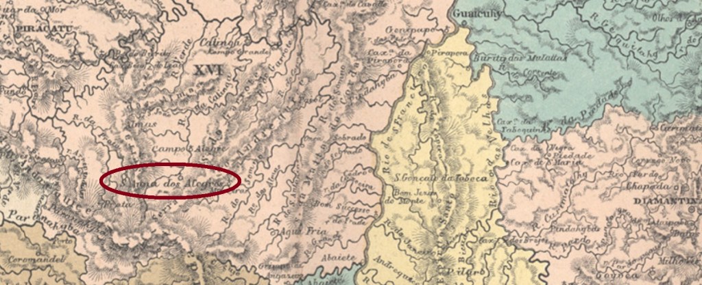
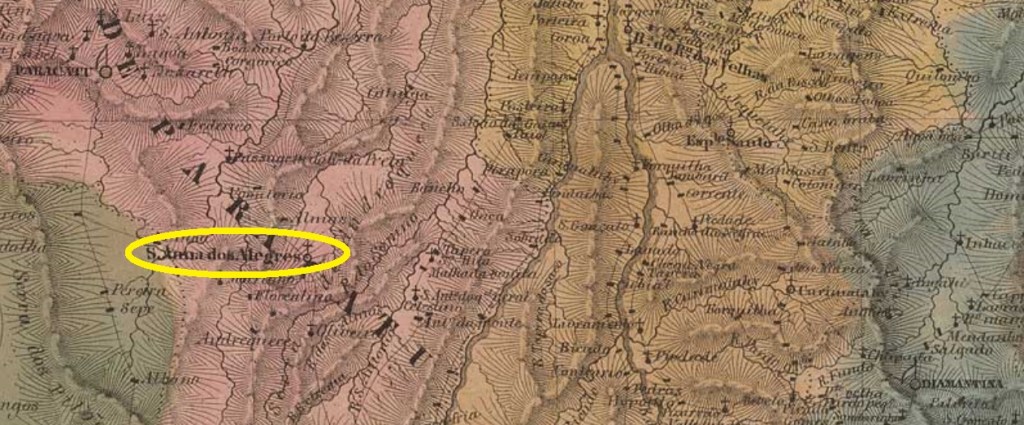
Sant’Anna dos Alegres was since August 1813 a freguesia of the municipality of Paracatu, situated almost 500 km northwest of the old province capital Ouro Preto. A local legend says Alegre (=Happy) was the name of an ox that used to moo joyfully during the whole night and so named the entire village. Se non è vero, è ben trovato.
The freguesia ascended to a district in November 1873 and emancipated in August 1911 as the villa of João Pinheiro. The name is a tribute to João Pinheiro da Silva (1860-1908), who was twice president of the Minas Gerais state: in 1890 and from 1906 until his death.
According to Paula Sobrinho (História Postal de Minas Gerais, Belo Horizonte, 1997), the local post office was created in July 1882. One early cancel was found: SMG-2780a (Coll. Márcio Protzner) has a double circle with the inscription S. ANNA DOS ALEGRES above and a diamond ornament below, whose four sides are open. The unique example has a date of 1897 at the centre.
Villiers de l’Ile Adam: Carta (…) da Provincia de Minas Geraes
Andere Namen: Alegres, João Pinheiro (1911)
Sant’Anna dos Alegres war seit August 1813 eine Freguesia im Município von Paracatu, die fast 500 km nordwestlich der ehemaligen Provinzhauptstadt Ouro Preto entfernt lag. Einer Ortssage zufolge hieß Alegre (= fröhlich) ein Ochse, der gut und gerne durch die ganze Nacht gemuht und dadurch die gesamte Ortschaft geprägt hat. Se non è vero, è ben trovato.
Die Freguesia stieg im November 1873 zum Distrikt auf und wurde ein Município im August 1911, der Villa de João Pinheiro hieß. Der Name ist eine Hommage an João Pinheiro da Silva (1860-1908), der zweimal Präsident des Staates Minas Gerais war: 1890 und von 1906 bis zu seinem Tod.
Laut Paula Sobrinho (História Postal de Minas Gerais, Belo Horizonte, 1997) gibt es das örtliche Postamt seit Juli 1882. Ein früher Stempel war zu finden: SMG-2780a (Samml. Márcio Protzner) hat einen Doppelkreis mit der Inschrift S. ANNA DOS ALEGRES oben und einem rautenförmigen Ornament unten, dessen vier Seiten offen sind. Das einzige Exemplar trägt ein Datum von 1897 in der Mitte.