Villiers de l’Ile Adam: Carta (…) da Provincia do Maranhão, 1850
Other names: São José do Periá, Humberto de Campos (1934)
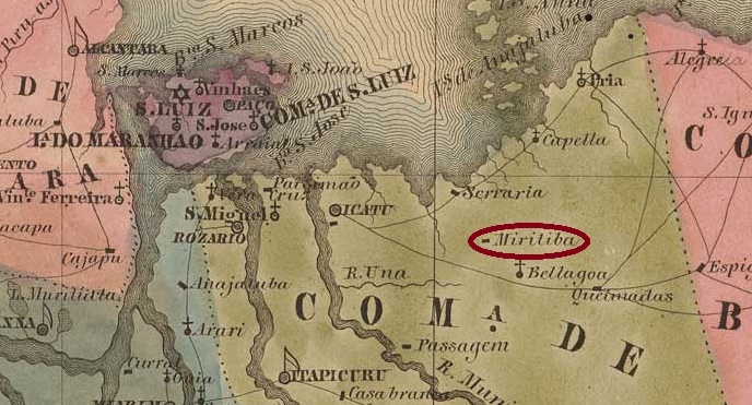
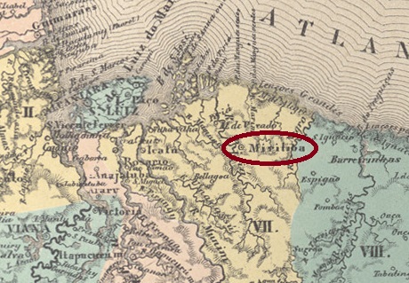
The place was originally called Arraial de São José do Periá and was located on the west bank of the Rio Periá, 180 kilometres east of the later provincial capital São Luís do Maranhão. In May 1835, it became a parish of the Vila de Icatu. In July 1859, it was elevated to the status of a vila under the name Miritiba de São José do Periá. Since December 1934, the town has been called Município de Humberto de Campos in honour of the politician, journalist and writer (1886–1934) who was born in Miritiba. The word ‘Miritiba’ comes from the Tupi language and means ‘many reeds’.
Humberto de Campos, in 1926 (Correio da Manhã)
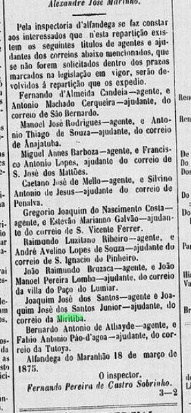
As reported by the regional press, there had been a post office there since February 1875:
Diario do Maranhão, 25 March 1875
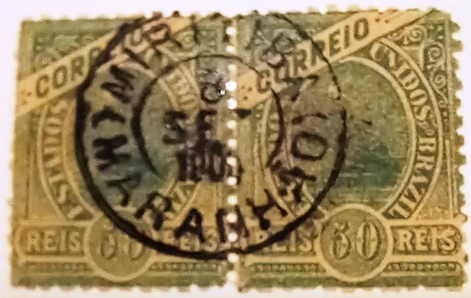
The oldest postmark to date, MMA-0165b (Fuad Ferreira Fo. collection), already bears a date from the Republic:
MMA-0165b (FF) 1904Atlas do Imperio do Brasil, 1868
Andere Namen: São José do Periá, Humberto de Campos (1934)
Der Ort hieß ursprünglich Arraial de São José do Periá und lag am Westufer des Rio Periá, 180 Kilometer östlich der späteren Provinzhauptstadt São Luís do Maranhão. Im Mai 1835 wurde er zur Freguesia der Vila de Icatu. Im Juli 1859 erfolgte der Aufstieg zur Vila unter dem Namen Miritiba de São José do Periá. Seit Dezember 1934 trägt der Ort den Namen Município de Humberto de Campos zu Ehren des Politikers, Journalisten und Schriftstellers (1886–1934), der in Miritiba geboren wurde. Das Wort „Miritiba” kommt aus dem Tupi und bedeutet „viele Schilfröhrchen”.
Humberto de Campos, 1926 (Correio da Manhã)
Wie die regionale Presse bekannt gab, gab es dort seit Februar 1875 ein Postamt:
Diario do Maranhão, 25.03.1875
Der bisher älteste Poststempel MMA-0165b (Samml. Fuad Ferreira Fo.) trägt bereits ein Datum der Republik:
Villiers de l’Ile Adam: Carta (…) da Provincia do Mato Grosso, 1850
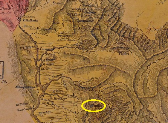
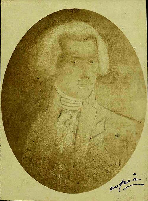
The Nossa Senhora do Carmo do Rio Mondego prison was built in July 1778 on the east bank of the Mondego River (now Miranda), 810 kilometres south of what would later become the provincial capital of Cuiabá. In August 1835, the village was declared Freguesia de Nossa Senhora do Carmo de Miranda in the territory of Vila de Corumbá. This was followed by two promotions to Vila in May 1857 and October 1871, as Miranda had been downgraded to Freguesia again in November 1869 at the end of the war against Paraguay. Since July 1918, Miranda has been a city, which has been in the state of Mato Grosso do Sul since January 1979. The place name commemorates the Portuguese Caetano Pinto de Miranda Montenegro (1748–1827), Marquês de Vila Real de Praia Grande, who was governor of the Captaincy of Mato Grosso from 1796 to 1803.
Miranda Montenegro (Wikipedia)
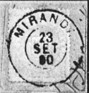
Two dates of origin have been found for the local post office: first in June 1850, as R. Koester writes in Carimbologia XXVII, then again in October 1853, as noted in Nova Monteiro’s Administrações e Agencias Postaes do Brasil Imperio (Brasil Filatelico/RJ, 1934–1935; reprinted SPP 1994–1999).
The only imperial postmark to date is MMT-0040b (Fig. Koster, op. cit.):
MMT-0040b (RK) 1883-1890Atlas do Imperio do Brasil, 1868
Das Gefängnis Nossa Senhora do Carmo do Rio Mondego wurde im Juli 1778 am Ostufer des Flusses Mondego (heute Miranda) erbaut, 810 Kilometer südlich der späteren Provinzhauptstadt Cuiabá. Im August 1835 wurde die Ortschaft als Freguesia de Nossa Senhora do Carmo de Miranda im Gebiet der Vila de Corumbá erklärt. Es folgten zwei Aufstiege zur Vila im Mai 1857 und im Oktober 1871, da Miranda im November 1869, am Ende des Krieges gegen Paraguay, wieder zur Freguesia herabgestuft wordem war. Seit Juli 1918 ist Miranda eine Stadt, die seit Januar 1979 im Bundesstaat Mato Grosso do Sul liegt. Der Ortsname erinnert an den Portugiesen Caetano Pinto de Miranda Montenegro (1748–1827), Marquês de Vila Real de Praia Grande, der von 1796 bis 1803 Gouverneur der Kapitanerie von Mato Grosso war.
Miranda Montenegro (Wikipedia)
Für das örtliche Postamt wurden zwei Entstehungsdaten gefunden: erstmals im Juni 1850, wie R. Koester in Carimbologia XXVII schreibt, dann wieder im Oktober 1853, wie in Nova Monteiros Administrações e Agencias Postaes do Brasil Imperio (Brasil Filatelico/RJ, 1934–1935; Nachdruck SPP 1994–1999) vermerkt.
Der bisher einzige kaiserliche Poststempel ist MMT-0040b (Abb. Koster, op. cit.):
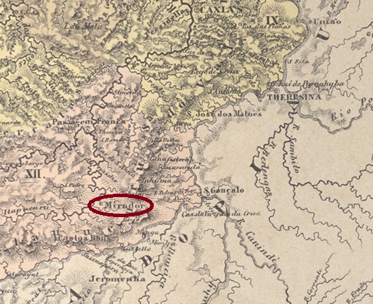
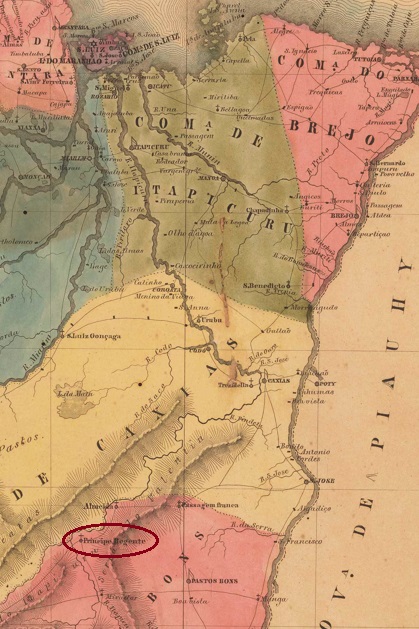
Arraial do Príncipe Regente was founded around 1820 on the Itapecuru River, 490 km south of the future provincial capital São Luís do Maranhão. On old maps, the settlement is located on the east bank, but today it lies on the west bank. The crown prince (Príncipe Regente) here is the Brazilian emperor Dom Pedro I, who later became the Portuguese king Dom Pedro IV. Under this name, it was elevated to the status of a vila in June 1855, which became a district of Vila de Pastos Bons in September 1861. In June 1866, it was renamed Freguesia de S. Bento do Mirador, which became a municipality in July 1870 and a town in 1938. According to local legend, the place name Mirador comes from a short-sighted resident. However, it is more likely that the name means ‘viewpoint’ and refers to a hill along the Itapecuru.
In Carimbologia XXVII, R. Koester mentions two dates for the establishment of the local post office: in October 1872 and in 1879. The first date is confirmed in the postal report (Relatorio dos Correios) for 1886, and postal activities are documented for 1874 and 1875. In this respect, the second date – if correct – refers to a reopening.
No imperial postmark from Mirador has been found to date.
Villiers de l’Ile Adam: Carta (…) da Provncia do Maranhão, 1850
Andere Namen: Principe Regente
Der Arraial do Príncipe Regente entstand um 1820 am Fluss Itapecuru, 490 km südlich der späteren Provinzhauptstadt São Luís do Maranhão. Auf alten Karten liegt die Siedlung am Ostufer, heute liegt sie jedoch am Westufer. Der Kronprinz (Príncipe Regente) ist hier der brasilianische Kaiser Dom Pedro I., der später der portugiesische König Dom Pedro IV. wurde. Unter diesem Namen erfolgte im Juni 1855 der Aufstieg zur Vila, die im September 1861 ein Distrikt der Vila de Pastos Bons wurde. Im Juni 1866 erfolgte die Umbenennung in Freguesia de S. Bento do Mirador, die im Juli 1870 zur Gemeinde und 1938 zur Stadt wurde. Einer lokalen Legende zufolge stammt der Ortsname Mirador von einem kurzsichtigen Bewohner. Wahrscheinlicher ist jedoch, dass der Name Aussichtspunkt bedeutet und sich auf eine Anhöhe entlang des Itapecuru bezieht.
R. Koester nennt in Carimbologia XXVII zwei Zeitpunkte für die Entstehung des örtlichen Postamts: Oktober 1872 bzw. 1879. Der erste Termin wird im Postbericht (Relatorio dos Correios) für 1886 bestätigt und es sind Postaktivitäten für 1874 und 1875 belegt. Insofern handelt es sich beim zweiten Termin – falls er korrekt ist – um eine Wiedereröffnung.
Bisher wurde kein kaiserlicher Poststempel aus Mirador gefunden.
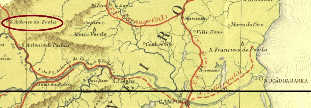
See also Brotos (BRJ-1565) and Santo Antonio dos Brotos (SRJ-1565)
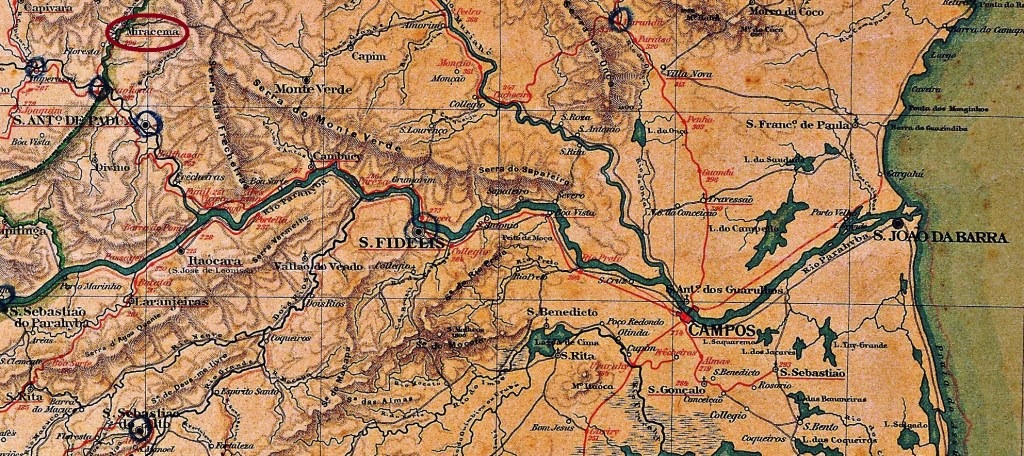
Santo Antonio dos Brotos (also written das Brotas or da Brota) was a district of São Fidellis, situated almost 300 km north of the imperial capital Rio de Janeiro. In March 1883 the place name changed to Miracema, which emancipated as an own municipality in November 1935.
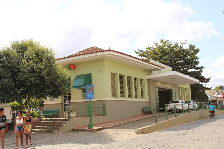
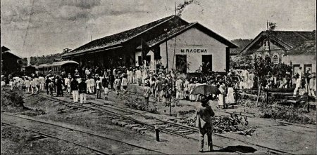
Miracema Station was opened in August 1883 by the Estrada de Ferro Sto. Antonio de Pádua railway company (Campos–Miracema line) and belonged to the municipality of Sto. Antonio de Pádua. The railway line changed hands in 1884 and was transferred to E.F. Macaé e Campos. From 1887 until its closure in 1970, it belonged to E.F. Leopoldina (estacoesferroviarias.com.br). Today, the tracks have been removed and the station building is used as a bus station.
In 1917 (Fon-Fon, on estacoesferroviarias.com.br)In June 2021 (photo: Júlio Alves, estacoesferroviarias.com.br)
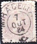
According to P. Novaes (agenciaspostais.com.br), the station post office was opened in January 1884. The old post office in the village remained in operation until August 1885. The first imperial postmark is MRJ-1700a (image from the Internet) and bears the curious accent error ‘Mirácema’:
MRJ-1700a (EB) 1884–1889
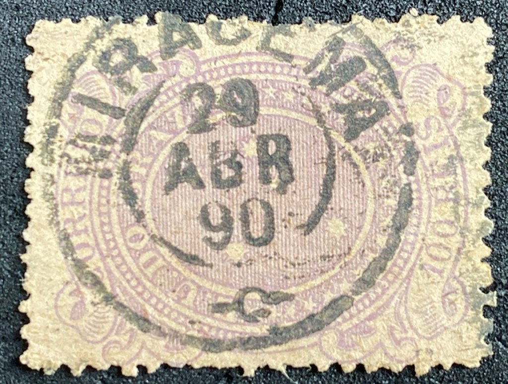
There followed shortly before the end of the Brazilian Empire MRJ-1700b (Image by Felipe Piccinini):
MRJ-1700b (FP) 1889–1890E.F. Central do Brasil, 1890
Texto atualizado em 13 de maio de 2026
Veja também Brotos (BRJ-1565) e Santo Antonio dos Brotos (SRJ-1565)
Santo Antonio dos Brotos (também escrito das Brotas ou da Brota) era um distrito de São Fidélis, situado quase 300 km ao norte da capital imperial capital Rio de Janeiro. Em março de 1883 o topônimo mudou para Miracema, que teve sua emancipação municipal em novembro de 1935.
A estação ferroviária de Miracema foi inaugurada em agosto de 1883 pela Estrada de Ferro Sto. Antonio de Pádua (linha Campos–Miracema) e pertencia então ao município de Sto. Antonio de Pádua. Em 1884, a linha ferroviária mudou para a E.F. Macaé e Campos. De 1887 até o fechamento em 1970, pertenceu à E.F. Leopoldina (estacoesferroviarias.com.br). Hoje, os trilhos foram removidos e o prédio da estação é usado como terminal rodoviário.
Em 1917 (Revista Fon-Fon, em estacoesferroviarias.com.br)Em junho de 2021 (Foto: Júlio Alves, estacoesferroviarias.com.br)
De acordo com P. Novaes (agenciaspostais.com.br), a agência dos correios da estação foi inaugurada em janeiro de 1884. A antiga agência dos correios na localidade permaneceu em funcionamento até agosto de 1885. O primeiro carimbo postal imperial é MRJ-1700a (fig. da Internet) e apresenta o curioso erro de acento “Mirácema”:
MRJ-1700a (EB) 1884–1889
No final do Império surgiu também o MRJ-1700b (imagem: Felipe Piccinini):
MRJ-1700b (FP) 1889–1890Almanak Laemmert, 1892
Textaktualisierung am 13. Mai 2026
Siehe auch Brotos (BRJ-1565), Santo Antonio dos Brotos (SRJ-1565)
Santo Antonio dos Brotos (auch das Brotas oder da Brota geschrieben) war ein Distrikt von São Fidellis, der fast 300 km nördlich der kaiserlichen Hauptstadt Rio de Janeiro entfernt lag. Im März 1883 wechselte der Ortsname zu Miracema, der zu einer Stadt im eigenen Município im November 1935 aufstieg.
Der Bahnhof Miracema wurde im August 1883 von der Eisenbahngesellschaft Estrada de Ferro Sto. Antonio de Pádua (Linie Campos–Miracema) eröffnet und gehörte nun zum Munizipium de Sto. Antonio de Pádua. Die Bahnlinie wechselte 1884 den Besitzer und ging an die E.F. Macaé e Campos über. Von 1887 bis zur Stilllegung im Jahr 1970 gehörte sie der E.F. Leopoldina (estacoesferroviarias.com.br). Heute sind die Gleise entfernt, das Bahnhofsgebäude wird als Busbahnhof genutzt.
Im Jahr 1917 (Fon-Fon, auf estacoesferroviarias.com.br)Im Juni 2021 (Foto: Júlio Alves, estacoesferroviarias.com.br)
Das Bahnhofspostamt wurde laut P. Novaes (agenciaspostais.com.br) im Januar 1884 eröffnet. Das alte Postamt im Dorf blieb bis August 1885 in Betrieb. Der erste kaiserliche Poststempel ist MRJ-1700a (Abb. aus dem Internet) und trägt den kuriosen Akzentfehler „Mirácema”:
MRJ-1700a (EB) 1884–1889
Es folgte kurz vor dem Ende des brasilianischen Kaiserreichs MRJ-1700b (Abb. Felipe Piccinini):
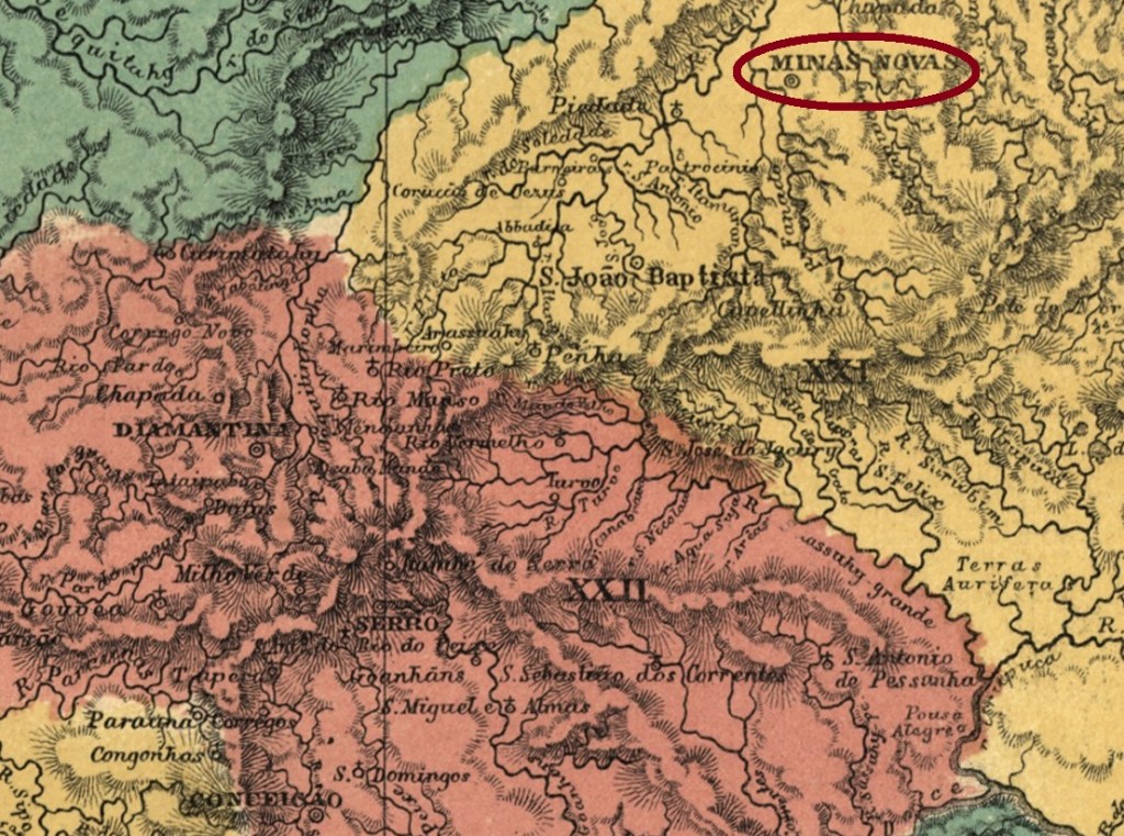
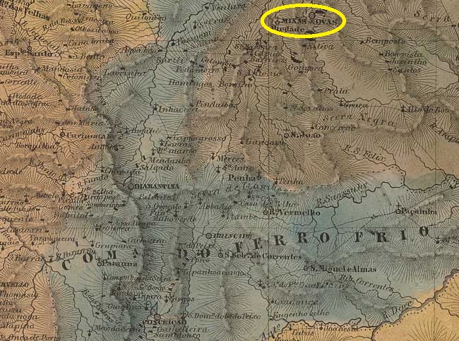
The Arraial de São Pedro do Fanado has been documented since 1727. The settlement was located on the eastern bank of the Fanado River, 550 kilometres north of what would later become the provincial capital, Ouro Preto. In 1728, it became the Freguesia de Nossa Senhora do Bom Successo das Minas do Fanado, which in October 1730 became the Vila de Nossa Senhora do Bom Successo das Minas Novas and finally, in March 1840, the town of Minas Novas.
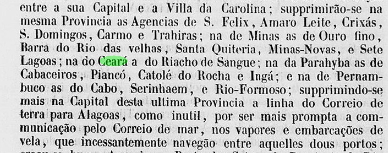
Three periods of operation of the local post office have been identified. The first began in October 1833, as both Paula Sobrinho in ‘História Postal de Minas Gerais’ (Belo Horizonte, 1997) and R. Koester in ‘Carimbologia XXVII’ write. We do not know when the agency was first closed, but Nova Monteiro writes in Administrações e Agencias Postaes do Brasil Imperio (Brasil Filatelico/RJ, 1934–1935; reprinted by SPP 1994–1999) that it reopened in April 1845. According to a report by the Imperial Ministry, this second period ended around 1850.
Relatorio do Ministerio do Imperio, 1850
The date of the third opening is also unknown, but it must have taken place before 1853.
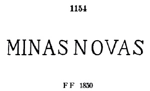
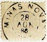
The oldest postmark to date is the pre-philatelic MMG-1610a, which occurs both with and without a margin. It was given the number 1154 by P. Ayres in Catálogo de Carimbos Brasil-Império (S. Paulo, 1937, 1942) and is listed in the RHM catalogue under P-MG-38.
MMG-1610a (P.A. 1154, RHM P-MG-38) 1835-1866ff
This was followed by the rare MMG-1610b (Fig. José Renato C. de Souza), which has not yet been definitively confirmed:
MMG-1610b (JR) 1877ff
Towards the end of the Empire, the double circle MMG-1610c (Fig. Felipe Piccinini) also appeared:
MMG-1610c (FP) 1885-1896Villiers de l’Ile Adam: Carta (…) da Provincia de Minas Geraes, 1849
Andere Namen: São Pedro do Fanado
Der Arraial de São Pedro do Fanado ist seit 1727 überliefert. Die Siedlung lag am Ostufer des Fanado, 550 Kilometer nördlich der späteren Provinzhauptstadt Ouro Preto. Im Jahr 1728 wurde sie zur Freguesia de Nossa Senhora do Bom Successo das Minas do Fanado, die im Oktober 1730 zur Vila de Nossa Senhora do Bom Successo das Minas Novas und im März 1840 schließlich zur Stadt Minas Novas wurde.
Es wurden drei Betriebsperioden des örtlichen Postamts festgestellt. Die erste begann im Oktober 1833, wie sowohl Paula Sobrinho in „História Postal de Minas Gerais” (Belo Horizonte, 1997) als auch R. Koester in „Carimbologia XXVII” schreiben. Wir wissen nicht, wann die Agentur erstmals geschlossen wurde, aber Nova Monteiro schreibt in Administrações e Agencias Postaes do Brasil Imperio (Brasil Filatelico/RJ, 1934–1935; Nachdruck SPP 1994–1999), dass sie im April 1845 wieder öffnete. Diese zweite Periode endete laut Bericht des Imperialministeriums um 1850.
Relatorio do Ministerio do Imperio, 1850
Das Datum der dritten Eröffnung ist ebenfalls noch unbekannt, diese muss jedoch vor 1853 stattgefunden haben.
Der bisher älteste Poststempel ist der vorphilatelistische MMG-1610a , der sowohl mit als auch ohne Rand vorkommt. Er bekam von P. Ayres die Nr. 1154 in Catálogo de Carimbos Brasil-Império (S. Paulo, 1937, 1942) und wird im RHM-Katalog unter P–MG-38 aufgeführt.
MMG-1610a (P.A. 1154, RHM P-MG-38) 1835-1866ff
Es folgte der seltene MMG-1610b (Abb. José Renato C. de Souza), der noch nicht endgültig bestätigt werden konnte:
MMG-1610b (JR) 1877ff
Gegen Ende des Kaiserreichs erschein auch der Doppelkreis MMG-1610c (Abb. Felipe Piccinini):
Villiers de l’Ile Adam: Carta (…) da Provincia de Minas Geraes, 1849
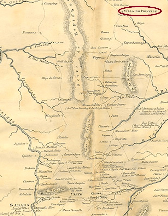
Other names: Grande Serro do Frio, Arraial das Lavras Velhas do Ivituruhy, Villa do Principe, Cidade do Serro
See also Serro (SMG-3100) and Villa do Principe (VMG-3820)
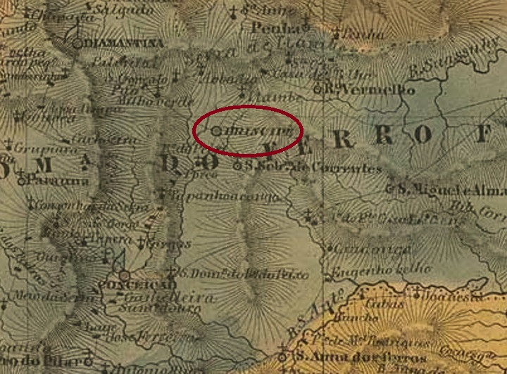
This very old settlement was already named Villa do Principe in January 1714, located in the north of the Capitania of Minas Gerais, 330 km north of the future provincial capital Ouro Preto. In March 1838, the place rose to become a town, and is today a tourist magnet as a historical site.
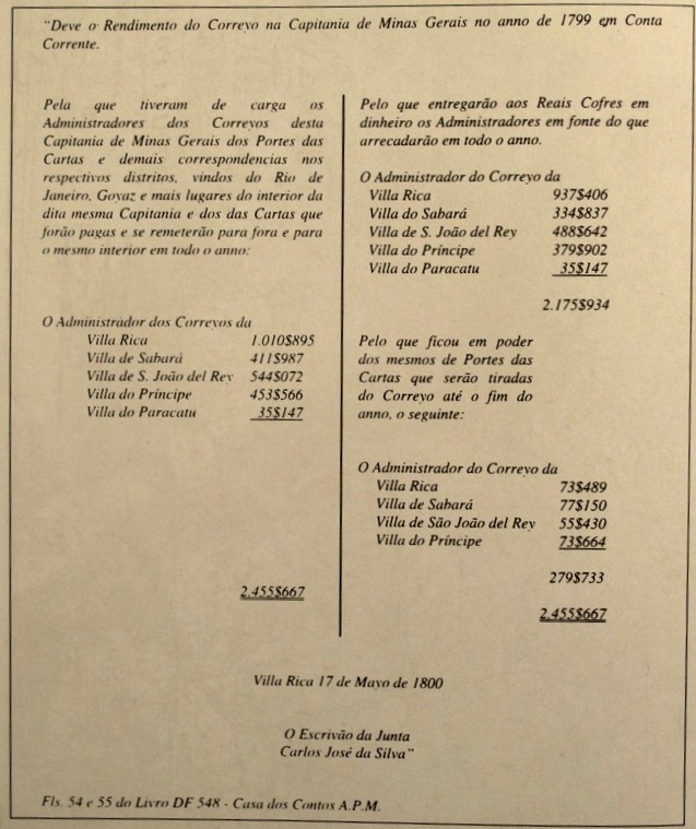
Paula Sobrinho writes in História Postal de Minas Gerais (Belo Horizonte, 1997) that there was a post office there from March 1798. This can be supported by a document discovered and published by the Portuguese philatelist Luís Brito Frazão, the balance sheet figures of the five post offices in Minas Gerais for the fiscal year 1799:
Jornal de Filatelia No. 64, Oporto, January 2001
Later post office openings are said to have taken place in 1829 and 1836, as recorded in the Directory of Imperial Post Offices (Tabella das Agencias do Correio do Imperio, Rio de Janeiro, 1885) and in the Catálogo Enciclopédico RHM (São Paulo, 1999) respectively. The oldest postmark is probably VMG-3820a, which was already presented in the RHM catalogue under P-MG-51 and was probably in use before 1840:
VMG-3820a (RHM P-MG-51)
Between 1822 and 1840, MMG-3780a was also used, which also appears in red and sepia and was given the number P-MG-37 in the RHM catalogue:
MMG-3780a (RHM P-MG-37)
Later postmarks bear the place name Serro and can be found under SMG-3100.
Province of Minas Geraes, 1835
Andere Namen: Grande Serro do Frio, Arraial das Lavras Velhas do Ivituruhy, Villa do Principe, Cidade do Serro
Siehe auch Serro (SMG-3100) und Villa do Principe (VMG-3820)
Diese sehr alte Siedlung war bereits im Januar 1714 die Villa do Principe und lag im Norden der Capitania von Minas Gerais, 330 km nördlich der künftigen Provinzhauptstadt Ouro Preto entfernt. Im März 1838 stieg der Ort zur Stadt auf und ist bis heute als historische Stätte ein Touristenmagnet.
Paula Sobrinho schreibt in História Postal de Minas Gerais (Belo Horizonte, 1997) dass es dort ab März 1798 ein Postamt gab. Das kann durch ein Dokument bestätigt werden, das vom portugiesischen Philatelisten Luís Brito Frazão entdeckt und veröffentlicht wurde, die Bilanzzahlen der fünf Postämter in Minas Gerais fürs Geschäftsjahr 1799:
Jornal de Filatelia Nr. 64, Porto, Januar 2001
Spätere Postamteröffnungen sollen 1829 und 1836 stattgefunden haben, wie im Verzeichnis der kaiserlichen Postämter (Tabella das Agencias do Correio do Imperio, Rio de Janeiro, 1885) bzw. im Catálogo Enciclopédico RHM (São Paulo, 1999) registriert wurde. Der älteste Poststempel ist wohl VMG-3820a, der bereits im RHM Katalog unter P-MG-51 vorgestellt wurde und vermutlich vor 1840 Verwendung fand:
VMG-3820a (RHM P-MG-51)
Zwischen 1822 und 1840 wurde auch MMG-3780a verwendet, der auch in Rot und Sepia vorkommt und die Nr. P-MG-37 im RHM-Katalog bekam:
MMG-3780a (RHM P-MG-37)
Spätere Poststempel tragen die Ortsbezeichnung Serro und sind unter SMG-3100 zu finden.
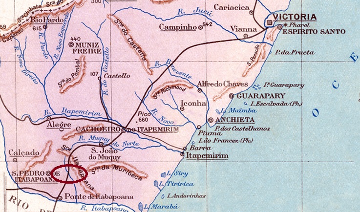
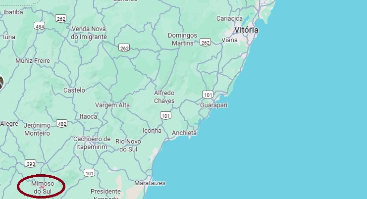
Since July 1887, Mimoso (Graceful) had been a settlement of Vila de São Pedro do Itabapoana, located on the southern bank of the Muqui do Sul, 180 km southwest of the provincial capital Vitória. Around 1889, the Vila was downgraded to Freguesia de São Pedro do Cachoeiro do Itapemerim. In June 1890, the town moved to the newly founded Município de Monjardim and became the seat of the municipality of São Pedro do Itabapoana in January 1930. This was followed by two changes to the town’s name: in November 1930 to João Pessoa and in December 1943 to Mimoso do Sul, which is still the name used today.
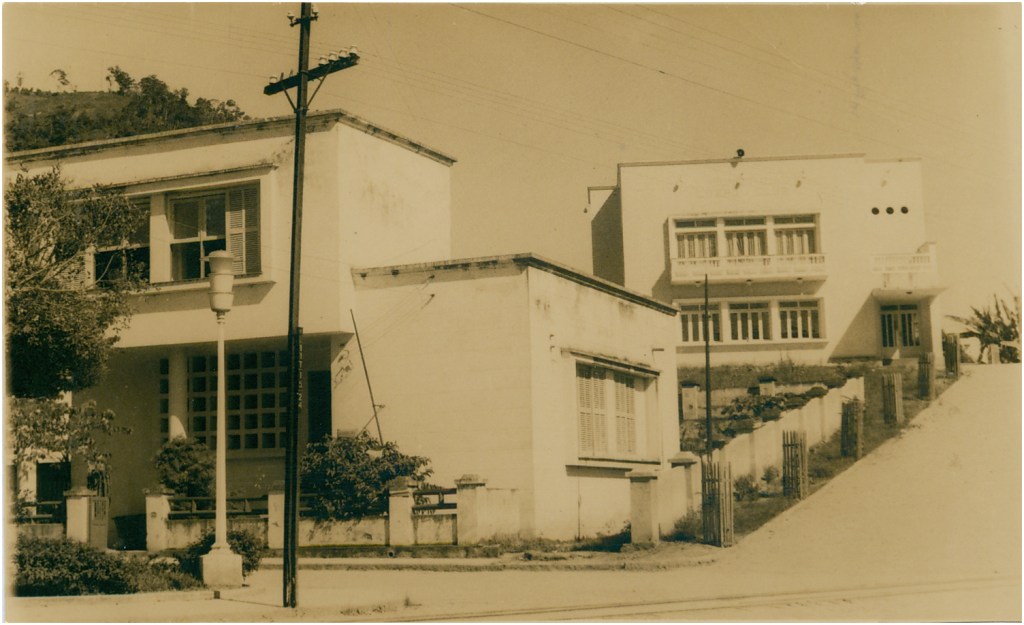
Mimoso do Sul post office, ca. 1960 (IBGE)
Paulo Novaes writes on agenciaspostais.com.br that the local post office was created in February 1888. However, as it had not yet begun operations in August 1889 and its official closure was decided in June 1890, it must have been opened during the Republic.
The oldest postmark to date is the double circle MES-0110a (Fig. agenciaspostais.com.br):
MES-0110a (PN) 1902Google Maps
Andere Namen: João Pessoa, Mimoso do Sul (1943)
Mimoso (Anmutig) war seit Juli 1887 eine Siedlung der Vila de São Pedro do Itabapoana, die am Südufer des Muqui do Sul lag, 180 km südwestlich der Provinzhauptstadt Vitória. Die Vila wurde um 1889 zur Freguesia de São Pedro do Cachoeiro do Itapemerim herabgestuft. Im Juni 1890 wechselte der Ort zum neu gegründeten Município de Monjardim und wurde im Januar 1930 Sitz der Gemeinde São Pedro do Itabapoana. Es folgten zwei Änderungen des Ortsnamens: im November 1930 in João Pessoa und im Dezember 1943 in Mimoso do Sul, der bis heute gültigen Bezeichnung.
Postamt Mimoso do Sul, ca. 1960 (IBGE)
Paulo Novaes schreibt auf agenciaspostais.com.br, dass es dort seit Februar 1888 ein Postamt geben sollte. Da dieses aber im August 1889 seinen Betrieb noch nicht aufgenommen hatte und im Juni 1890 die offizielle Schließung beschlossen wurde, muss es wohl erst in der Republik eröffnet worden sein.
Der bisher älteste Poststempel ist der Doppelkreis MES-0110a (Abb. agenciaspostais.com.br):
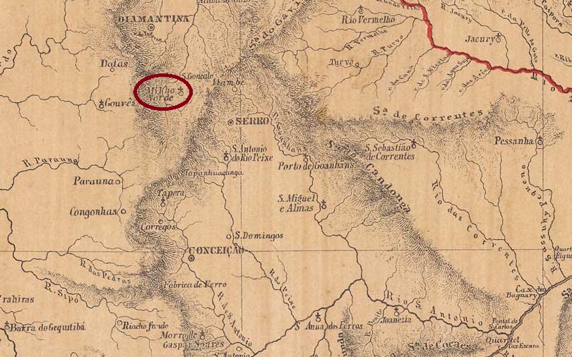
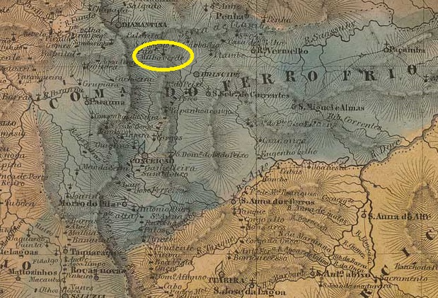
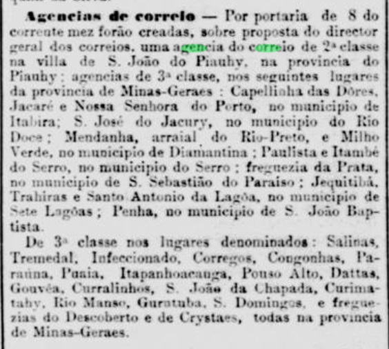
Arraial do Milho Verde has been documented since July 1857. It belonged to the city of Serro, located 20 kilometres north of the source of the Jequitinhonha River and 360 kilometres north of the provincial capital Ouro Preto. In July 1868, it was elevated to the status of Freguesia de Nossa Senhora dos Prazeres do Milho Verde. Today it is a district in the municipality of Serro. The strange-sounding place name (Green Corn) is said to commemorate a portuguese settler named Manuel Rodrigues Milho Verde.
Both Paula Sobrinho (História Postal de Minas Gerais, Belo Horizonte, 1997) and R. Koester (Carimbologia XXVII) write that there has been a post office there since July 1881. However, this could be a transcription error, as the press in Rio de Janeiro did not report the creation of the agency until November of the same year:
Jornal do Commercio/RJ, 12 November 1881
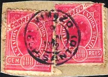
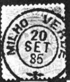
The only imperial postmark to date is the double circle MMG-1605a (Fig. Koester, op. cit.):
MMG-1605a (RK) 1885-1890ffVilliers de l’Ile Adam: Carta (…) da Provncia de Minas Geraes, 1849
Der Arraial do Milho Verde ist seit Juli 1857 überliefert. Er gehörte zur Stadt Serro, lag 20 Kilometer nördlich der Quelle des Jequitinhonha und 360 Kilometer nördlich der Provinzhauptstadt Ouro Preto. Im Juli 1868 wurde er zur Freguesia de Nossa Senhora dos Prazeres do Milho Verde erhoben. Heute ist er ein Distrikt im Município de Serro. Der seltsam anmutende Ortsname (Grüner Mais) soll angeblich an einen Siedler namens Manuel Rodrigues Milho Verde erinnern.
Sowohl Paula Sobrinho (História Postal de Minas Gerais, Belo Horizonte, 1997) als auch R. Koester (Carimbologia XXVII) schreiben, dass es dort seit Juli 1881 ein Postamt gab. Hier könnte es sich jedoch um einen Abschreibfehler handeln, denn die Presse aus Rio de Janeiro meldete die Agenturentstehung erst im November desselben Jahres:
Jornal do Commercio/RJ, 12.11.1881
Der bisher einzige kaiserliche Poststempel ist der Doppelkreis MMG-1605a (Abb. Koester, op. cit.):
Villiers de l’Ile Adam Carta (…) da Capitania do Ceara, 1849
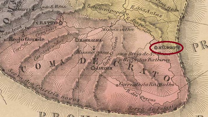
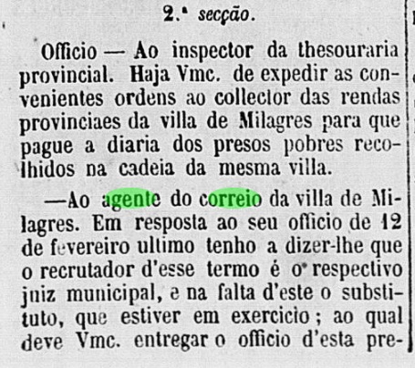
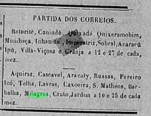
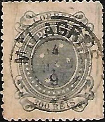
The Freguesia de Nossa Senhora dos Milagres existed since December 1842 and belonged to Vila do Crato. It was located on the south bank of the Rio dos Porcos in the Cariri region, 480 kilometres south of the provincial capital Fortaleza. In August 1846, the place was declared a vila and in July 1890 a city.
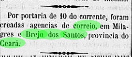
R. Koester writes in Carimbologia XXVII that there was a post office creation there inApril 1885. This is confirmed by the press in Rio.
Brazil/RJ, 11.04.1885
However, this was probably a reopening of the agency, as postal traffic to and from Milagres already existed between at least 1864 and 1865:
O Cearense, 6 May 1864O Cearense, 6 April 1865
The only postmark from the 19th century to date is the double circle MCE-0220b (image from the Internet):
MCE-0220b (EB) 1890-1894Carta da Capitania do Ceara, 1818
Die Freguesia de Nossa Senhora dos Milagres bestand seit Dezember 1842 und gehörte zur Vila do Crato. Sie lag am Südufer des Rio dos Porcos in der Cariri-Region, 480 Kilometer südlich der Provinzhauptstadt Fortaleza. Im August 1846 wurde der Ort zur Vila und im Juli 1890 zur Stadt erklärt.
R. Koester schreibt in Carimbologia XXVII, dass es dort seit April 1885 ein Postamt gab. Dies wird durch die Presse aus Rio bestätigt.
Brazil/RJ, 11.04.1885
Allerdings handelte es sich hierbei um eine Wiedereröffnung der Agentur, da zwischen zumindest 1864 und 1865 bereits Postverkehr von und nach Milagres existierte und das Postamt ausdrücklich erwähnt wurde:
O Cearense 06.05.1864O Cearense, 06.04.1865
Der bisher einzige Poststempel im 19. Jahrhunder ist der Doppelkreis MCE-0220b (Abb. aus dem Internet):
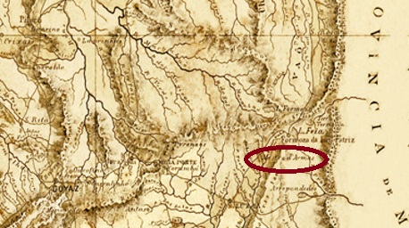
Villiers de l’Ile Adam: Carta (…) da Provincia de Goyaz, 1849
Other names: Altamir, S. Gabriel de Goiás, Planaltina (1917–1965, 1967)
As early as 1812, there was mention of a settlement called Mestre d’Armas, located on the southern shore of Lake Formosa, 350 kilometres east of what would later become the provincial capital of Goyaz (now Goiás Velho). The strange-sounding place name refers to a well-known armourer who lived there. The place continued to grow, becoming a district of Vila de Formosa in August 1859, Freguesia de São Sebastião do Mestre d’Armas in April 1880 and a vila in March 1891. After that, the place name changed four times: in July 1910 to Altamir, in June 1917 to Planaltina, in October 1965 to São Gabriel de Goiás and finally in February 1967 back to Planaltina. Today, there is a risk of confusion with a district 25 km to the south in the Federal District called SH Mestre d’Armas – Planaltina.
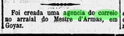
As reported by the Rio press, there had been a post office there since November 1885.
Diario de Noticias/RJ, 18 November 1885
However, no imperial postmark from Mestre d’Armas has been found to date.
Mappa da Provincia de Goyaz, 1874
Andere Namen: Altamir, S. Gabriel de Goiás, Planaltina (1917-1965, 1967)
Bereits seit 1812 war eine Siedlung namens Mestre d’Armas überliefert, die am Südufer des Formosa-Sees lag, 350 Kilometer östlich der späteren Provinzhauptstadt Goyaz (heute Goiás Velho). Der seltsam klingende Ortsname bezieht sich auf einen dort lebenden und weit bekannten Waffenschmied. Der Ort wuchs weiter, wurde im August 1859 ein Distrito der Vila de Formosa, im April 1880 die Freguesia de São Sebastião do Mestre d’Armas und im März 1891 eine Vila. Danach änderte sich der Ortsname viermal: im Juli 1910 zu Altamir, im Juni 1917 zu Planaltina, im Oktober 1965 zu São Gabriel de Goiás und schließlich im Februar 1967 erneut zu Planaltina. Heute besteht die Gefahr der Verwechslung mit einem 25 km südlich gelegenen Ortsteil im Distrito Federal, der SH Mestre d’Armas – Planaltina heißt.
Wie die Presse aus Rio bekannt gab, gab es dort seit November 1885 ein Postamt.
Diario de Noticias/RJ, 18.11.1885
Bisher wurde jedoch kein kaiserlicher Poststempel aus Mestre d’Armas gefunden.