Categories
Carimbologia C-D

Crixás, Goiás (CGO-0052)

Atlas do Imperio do Brasil, 1868

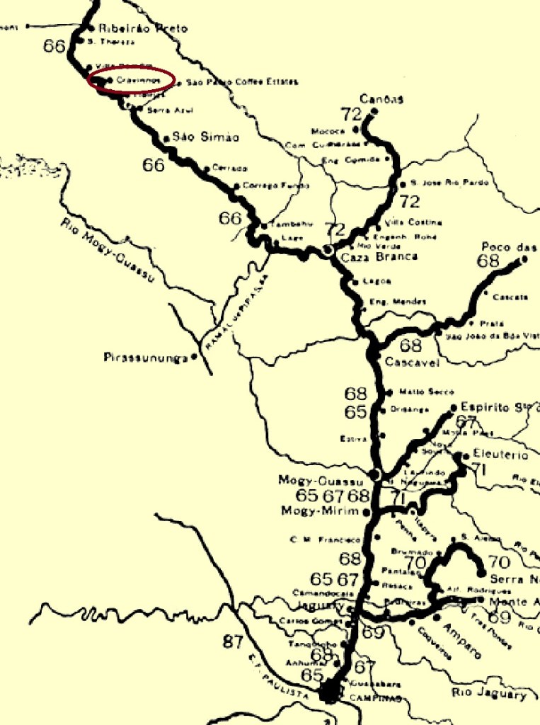
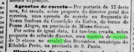
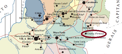
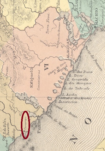
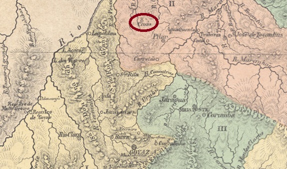
Kirixás was the name of an Indian tribe after which the Crixá-Açu and Crixá-Mirim rivers are named, around 200 kilometres north of the later provincial capital of Goyaz (now Goiás Velho). In January 1755, the Freguesia de N. Sra. da Conceição de Crixás was founded there, which belonged to the Vila de Pilar. In December 1943, Crixás became a district of the Município de Itacê and in October 1953 it became the Município de Crixás.

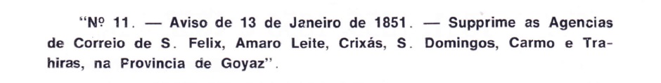
As Nova Monteiro wrote in Administrações e Agencias Postaes do Brasil Imperio (Brasil Filatelico/RJ, 1934-5; reprint SPP 1994-1999), there had been a post office there since March 1829. This was closed in January 1851, as Aureo G. Santos reports in Agências de Correio Criadas e Suprimidas 1851, 1855, 1856 e 1857 (Brasil Filatélico 181, Rio de Janeiro, 1977).

Aureo G. Santos (op. cit.)

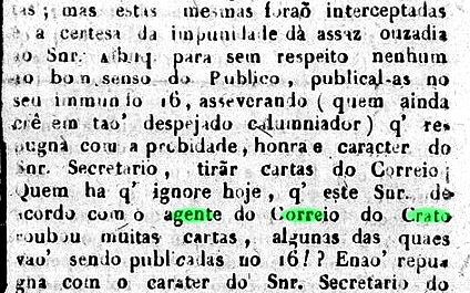
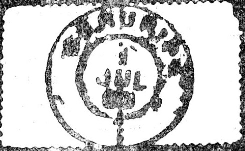
So far, no imperial postmark of Crixás has been found.

Villiers de l’Ile Adam: Carta (…) da Provincia de Goyaz, 1849

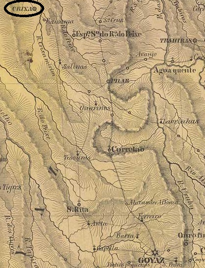
Kirixás war der Name eines Indianerstammes, nach dem die Flüsse Crixá-Açu und Crixá-Mirim benannt sind, etwa 200 km nördlich der späteren Provinzhauptstadt Goyaz (heute Goiás Velho). Im Januar 1755 wurde dort die Freguesia de N. Sra. da Conceição de Crixás gegründet, die zur Vila de Pilar gehörte. Im Dezember 1943 wurde Crixás ein Distrikt des Município de Itacê und im Oktober 1953 wurde daraus das Município de Crixás.

Wie Nova Monteiro in Administrações e Agencias Postaes do Brasil Imperio (Brasil Filatelico/RJ, 1934-5; Reprint SPP 1994-1999) schrieb, gab es dort seit März 1829 ein Postamt. Dieses wurde im Januar 1851 geschlossen, wie Aureo G. Santos in Agências de Correio Criadas e Suprimidas 1851, 1855, 1856 e 1857 (Brasil Filatélico 181, Rio de Janeiro, 1977) berichtet.

Aureo G. Santos (op. cit.)

Bisher wurde kein kaiserlicher Poststempel von Crixás gefunden.

Categories
Carimbologia C-D

Cravinhos (train station/Bahnhof), São Paulo (CSP-0400)

Cia. Mogyana, 1958 (IBGE)

Cravinhos railway station was opened in November 1883 by the E.F. Mogyana railway company in the Município de Ribeirão Preto, 300 km north of the provincial capital of São Paulo. Cravinhos, originally a fazenda in the region, became a district in April 1893, a município in July 1897 and a town in December 1906. The railway line was closed in 1964 and the tracks have disappeared, but the station building is currently being restored to make way for a cultural centre for the municipality.

Around 1908 (Photo: Album of the Cia. Mogyana, on estacoesferroviarias.com.br)
March 2022 (Photo: Prefeitura de Cravinhos)

As the Rio press reported, there had been a post office at the railway station since August 1881:

Jornal do Commercio/RJ, 01/09/1881

The oldest postmark to date is the French type CSP-0400a (image from the Internet)

CSP-0400a (SB) 1888-1897

At the beginning of the Republic, a handwritten cancellation was also used (image by Mário Celso Orsi Jr.)

1890ff (MO)
Estado de São Paulo, 1910

Der Bahnhof Cravinhos wurde im November 1883 von der Eisenbahngesellschaft E.F. Mogyana eröffnet im Município de Ribeirão Preto, 300 km nördlich der Provinzhauptstadt São Paulo. Cravinhos, ursprünglich eine Fazenda in der Region, wurde im April 1893 zum Distrikt, im Juli 1897 zum Município und im Dezember 1906 zur Stadt. Die Eisenbahnlinie wurde 1964 stillgelegt, die Gleise sind verschwunden, aber das Bahnhofsgebäude wird derzeit restauriert, um Platz für ein Kulturzentrum der Gemeinde zu schaffen.

Um 1908 (Foto: Album der Cia. Mogyana, auf estacoesferroviarias.com.br)
Im März 2022 (Foto: Prefeitura de Cravinhos)

Wie die Presse von Rio berichtete, gab es seit August 1881 ein Postamt am Bahnhof:

Jornal do Commercio/RJ, 01.09.1881

Der bisher älteste Poststempel ist der französische Typ CSP-0400a (Bild aus dem Internet)

CSP-0400a (SB) 1888-1897

Zu Beginn der Republik wurde auch eine handschriftliche Entwertung verwendet (Abb. Mário Celso Orsi Jr.)

1890ff (MO)
Categories
Carimbologia C-D

Crato, Ceará (CCE-0125)

Villiers de l’Ile Adam: Carta (…) da Provincia do Ceará, 1849

Other names: Miranda, Aldeia do Brejo Grande

In 1743, the Franciscan mission Miranda began in the Chapada do Araripe, 500 kilometres south of the later provincial capital Fortaleza. In August 1763, it became the Vila do Crato na Aldeia do Brejo Grande, which was elevated to town status almost 100 years later, in October 1853.

Both Nova Monteiro in Administrações e Agencias Postaes do Brasil Imperio (Brasil Filatelico/RJ, 1934-5; reprint SPP 1994-1999) and R. Koester (Carimbologia XIV) write that there had been a post office there since August 1846. However, the regional press mentions a local post office employee as early as 1839:

Correio da Assembleia Provincial, 02.11.1839, minutes of 16.09

The oldest postmark to date is CCE-0125b, already known from P. Ayres (Catálogo de Carimbos Brasil-Império, S. Paulo, 1937, 1942) with no. 1283;

CCE-0125b (P.A. 1283) 1877ff-1883

It was followed by the double circle CCE-0125c (illus. from the internet):

CCE-0125c (EB) 1885-1891

Koester (op. cit.) also shows the seal cancel CCE-0125d:

CCE-0125d (RK)
Carta da Capitania do Ceará, 1818

Andere Namen: Miranda, Aldeia do Brejo Grande

1743 begann die Franziskaner-Mission Miranda in der Chapada do Araripe, 500 km südlich der späteren Provinzhauptstadt Fortaleza. Im August 1763 wurde daraus die Vila do Crato na Aldeia do Brejo Grande, die knapp 100 Jahre später, im Oktober 1853, zur Stadt erhoben wurde.

Sowohl Nova Monteiro in Administrações e Agencias Postaes do Brasil Imperio (Brasil Filatelico/RJ, 1934-5; Reprint SPP 1994-1999) als auch R. Koester (Carimbologia XIV) schreiben, dass es dort seit August 1846 ein Postamt gab. In der regionalen Presse ist jedoch bereits 1839 von einem Postangestellten vor Ort die Rede:

Correio da Assembleia Provincial, 02.11.1839, Protokoll vom 16.09

Der bisher älteste Poststempel ist CCE-0125b, bereits bekannt durch P. Ayres (Catálogo de Carimbos Brasil-Império, S. Paulo, 1937, 1942) mit Nr. 1283;

CCE-0125b (P.A. 1283) 1877ff-1883

Ihm folgte der Doppelkreis CCE-0125c (Abb. aus dem Internet):

CCE-0125c (EB) 1885-1891

Koester (op. cit.) zeigt auch den Siegelstempel CCE-0125d:

CCE-0125d (RK)
Categories
Carimbologia C-D

Couto (train station/Bahnhof), Rio Grande do Sul (CRS-0130)

Estado do Rio Grande do Sul, 1891

Other names: Ramiz Galvão (1939)

Couto station was opened in March 1883 by the railway company E.F. Porto Alegre a Uruguayana and was located on the west bank of the Jacuí in the Município de Rio Pardo, 150 km west of the provincial capital Porto Alegre. The railway line was transferred to the Cie. Auxiliaire des Chemins de Fer au Brésil in 1898, to Viação Férrea Rio Grande do Sul in 1920 and belonged to Rede Ferroviária Federal S.A. from 1975 until its closure in 1996 (estacoesferroviarias.com.br). In 1939, the station was renamed Ramiz Galvão in memory of Benjamin Ramiz Galvão (1846-1938), a doctor, philologist and historian born in Rio Pardo.

Ramiz Galvão (Photo: Alman Garnier, Biblioteca Nacional)

Today the tracks are still there, the station building looks abandoned.

In March 2019 (Photo: Carlos Latuff on estacoesferroviarias.com.br)

According to the postal bulletin (Boletim Postal) from October 1889, the station post office was opened in September 1889:

Boletim Postal 6/89

The first postal employee was soon introduced in the regional press:

A Federação, 14/10/1889

R. Koester writes in Carimbologia XIV, however, that the postal agency only started work in December, i.e. already in the Republic. His assessment is confirmed by the fact that the first postmark CRS-0130a (illustration from the Internet) does not yet show any dates from the imperial period:

CRS-0130a (EB) 1890-1899

The Couto railway station is also known to have an ambulant postmark CRS-0130b (ill. Roberto Assef Jr.):

CRS-0130b (RA)
Estado do Rio Grande do Sul, 1924

Andere Namen: Ramiz Galvão (1939)

Der Bahnhof Couto wurde im März 1883 von der Eisenbahngesellschaft E.F. Porto Alegre a Uruguayana eröffnet und lag am Westufer des Jacuí im Município de Rio Pardo, 150 km westlich der Provinzhauptstadt Porto Alegre. Die Bahnlinie ging 1898 an die Cie. Auxiliaire des Chemins de Fer au Brésil, 1920 an die Viação Férrea Rio Grande do Sul und gehörte von 1975 bis zu ihrer Schließung 1996 der Rede Ferroviária Federal S.A. (estacoesferroviarias.com.br). 1939 wurde der Bahnhof in Ramiz Galvão umbenannt, in Erinnerung an den in Rio Pardo geborenen Arzt, Philologen und Historiker Benjamin Ramiz Galvão (1846-1938).

Ramiz Galvão (Foto: Alman Garnier, Biblioteca Nacional)

Heute sind die Gleise noch da, das Bahnhofsgebäude wirkt verlassen.

Im März 2019 (Foto: Carlos Latuff auf estacoesferroviarias.com.br)

Wie aus dem Postbulletin (Boletim Postal) vom Oktober 1889 hervorgeht, wurde das Bahnhofspostamt im September 1889 ins Leben gerufen:

Boletim Postal 6/89

Der erste Postangestellte wurde bald in der regionalen Presse vorgestellt:

A Federação, 14.10.89

R. Koester schreibt jedoch in Carimbologia XIV, dass die Postagentur erst im Dezember ihre Arbeit aufnahm, also bereits in der Republik. Seine Einschätzung wird dadurch bestätigt, dass der erste Poststempel CRS-0130a (Abb. aus dem Internet) noch keine Daten aus der Kaiserzeit aufweist:

CRS-0130a (EB) 1890-1899

Vom Bahnhof Couto ist auch der ambulante Poststempel CRS-0130b (Abb. Roberto Assef Jr.) bekannt:

CRS-0130b (RA)
Categories
Carimbologia C-D

Couros, Goiás (CGO-0052)

Villiers de l’Ile Adam: Carta (...) da Provincia de Goyaz, 1849

Other names: Villa Formosa da Imperatriz, Formosa (1877)

See also Formosa/GO (RK XIX)

Couros (pieces of leather) was from around 1750 an arraial of the Freguesia de Sta. Luzia on the west bank of the Rio Preto, 390 km east of the later provincial capital Goyaz (today: Goiás Velho). The village was elevated to a freguesia in August 1838 and five years later to Villa Formosa da Imperatriz. It has been the town of Formosa since July 1877.

As Nova Monteiro writes in Administrações e Agencias Postaes do Brasil Imperio (Brasil Filatelico/RJ, 1934-5; Reprint SPP 1994-1999), there had been a post office there since March 1829. A second post office is said to have been opened in February 1835, as R. Koester writes in Carimbologia XIX. This post office was still in operation in 1839, as can be seen from a report by the imperial ministry:

Relatorio do Ministerio do Imperio, 1839

No imperial postmark from Couros has yet been seen. It must be very rare.

Capitania de Goiás, 1809, by Teixeira Neto (apud Silva e Souza)

Andere Namen: Villa Formosa da Imperatriz, Formosa (1877)

Siehe auch Formosa/GO (RK XIX)

Couros (Lederstücke) war ab ca. 1750 ein Arraial der Freguesia de Sta. Luzia am Westufer des Rio Preto, 390 km östlich der späteren Provinzhauptstadt Goyaz (heute: Goiás Velho). Der Ort wurde im August 1838 zur Freguesia und fünf Jahre später zur Villa Formosa da Imperatriz erhoben. Seit Juli 1877 ist es die Stadt Formosa.

Wie Nova Monteiro in Administrações e Agencias Postaes do Brasil Imperio (Brasil Filatelico/RJ, 1934-5; Reprint SPP 1994-1999) schreibt, gab es dort seit März 1829 ein Postamt. Eine zweite Postamteröffnung soll im Februar 1835 stattgefunden haben, wie R. Koester in Carimbologia XIX schreibt. 1839 war dieses Postamt noch in Betrieb, wie aus einem Bericht des kaiserlichen Ministeriums hervorgeht:

Relatorio do Ministerio do Imperio, 1839

Bisher wurde noch kein kaiserlicher Poststempel aus Couros gesehen. Er muss sehr selten sein.

Categories
Carimbologia C-D

Cotia/Cutia, São Paulo (CSP-0395)

Villiers de l’Ile Adam: Carta (…) da Provincia de São Paulo, 1847

Other names: Acutia

The Freguesia de N. Sra. de Monte Serrat de Cutia (also spelt Cotia) was founded in 1723 and belonged to the Vila de São Paulo, from which it was located 30 kilometres to the west. It became a Vila in April 1856 and a town in December 1906.

Nova Monteiro writes in Administrações e Agencias Postaes do Brasil Imperio (Brasil Filatelico/RJ, 1934-5; reprint SPP 1994-1999) that there had been a post office there since April 1833. This first operation was short-lived, as the directory of imperial post offices (Tabella das Agencias do Correio do Imperio, Rio de Janeiro, 1885) shows a second post office opening in 1844.

The oldest postmark to date is CSP-0395a, which also exists in brown and was already presented by P. Ayres in the Catálogo de Carimbos Brasil-Império (S. Paulo, 1937, 1942) with no. 1287:

CSP-0395a (P.A. 1287) 1843ff-1850ff

It was followed by CSP-0395b, which also occurs in red and was also registered by P. Ayres, this time with the no. 1282:

CSP-0395b (P.A. 1282) 1850ff-1866ff

This was followed by circular cancellations, starting with the beautiful violet CSP-0395c (fig. Corinphila Auctions):

CSP-0395c (CO) 1872

It was followed by CSP-0395d (fig. R. Koester, in Carimbologia XIV):

CSP-0395d (RK) 1887-1892

Parallel to it there was the French type CSP-0395e (coll. Fuad Ferreira Fo.):

CSP-0395e (FF) 1889
Atlas do Imperio do Brasil, 1868

Andere Namen: Acutia

Die Freguesia de N. Sra. de Monte Serrat de Cutia (auch Cotia geschrieben) wurde 1723 gegründet und gehörte zur Vila de São Paulo, von der sie 30 km westlich entfernt lag. Der Ort wurde im April 1856 zur Vila und im Dezember 1906 zur Stadt erhoben.

Nova Monteiro schreibt in Administrações e Agencias Postaes do Brasil Imperio (Brasil Filatelico/RJ, 1934-5; Nachdruck SPP 1994-1999), dass es dort seit April 1833 ein Postamt gab. Dieser erste Betrieb war nur von kurzer Dauer, denn aus dem Verzeichnis der kaiserlichen Postämter (Tabella das Agencias do Correio do Imperio, Rio de Janeiro, 1885) geht hervor, dass 1844 eine zweite Postamteröffnung stattfand.

Der bisher älteste Stempel ist CSP-0395a, der auch in Braun existiert und bereits von P. Ayres im Catálogo de Carimbos Brasil-Império (S. Paulo, 1937, 1942) mit Nr. 1287 vorgestellt wurde:

CSP-0395a (P.A. 1287) 1843ff-1850ff

Ihm folgte CSP-0395b, der auch in rot vorkommt und ebenfalls von P. Ayres registriert wurde, diesmal mit der Nr. 1282:

CSP-0395b (P.A. 1282) 1850ff-1866ff

Es folgten Kreisstempel, beginnend mit dem schönen violetten CSP-0395c (Abb. Corinphila Auktionen):

CSP-0395c (CO) 1872

Und gefolgt von CSP-0395d (Abb. R. Koester, in Carimbologia XIV):

CSP-0395d (RK) 1887-1892

Parallel dazu gab es den französischen Typ CSP-0395e (Samml. Fuad Ferreira Fo.):

CSP-0395e (FF) 1889
Categories
Carimbologia C-D

Cotegipe, Bahia (CBA-0325)

Villiers de l’Ile Adam: Carta (…) da Provincia da Bahia, 1848

This locality in the state of Bahia is often confused with today’s Município de Cotegipe (formerly Campo Largo and Avaí), which lies over 800 kilometres to the west. Our Cotegipe is a former freguesia of the Vila de Salvador, which has been a district of the metropolis since August 1892. The word cotegipe means river of the agutis in Tupi-Guarani. In the empire, there was a Senator Barão de Cotegipe, alias João Mauricio Wanderley (1815-1889), who was born in what is now Bahia, but he only received this title in 1860 and therefore probably has no direct connection to this place.

Reinhold Koester writes in Carimbologia XIV that there had been a post office there since May 1889. This is confirmed by the postal bulletin of the following month:

Boletim Postal No. 2/June 1889

The oldest postmark so far is CBA-0325a, it will already be republican and was presented by Cicero A. de Almeida in Carimbos Postais – século XIX (Rio de Janeiro, 1989) under no. 774:

CBA-0325a (MPT-774)
Estado da Bahia, 1913

Dieser Ort im Bundesstaat Bahia wird oft mit dem heutigen Município de Cotegipe (ehemals Campo Largo und Avaí) verwechselt, das über 800 km weiter westlich liegt. Unser Cotegipe ist eine ehemalige Freguesia der Vila de Salvador, die seit August 1892 ein Stadtteil der Metropole ist. Das Wort cotegipe bedeutet auf Tupi-Guarani Fluss der Agutis. Im Kaiserreich gab es einen im heutigen Bahia geborenen Senator Barão de Cotegipe alias João Mauricio Wanderley (1815-1889), der diesen Titel allerdings erst 1860 erhielt und daher wohl keinen direkten Bezug zu diesem Ort hat.

Reinhold Koester schreibt in Carimbologia XIV, dass es dort seit Mai 1889 ein Postamt gab. Dies wird durch das Postbulletin des folgenden Monats bestätigt:

Boletim Postal Nr. 2/Juni 1889

Der bisher älteste Poststempel ist CBA-0325a, er wird bereits republikanisch sein und wurde von Cicero A. de Almeida in Carimbos Postais – século XIX (Rio de Janeiro, 1989) unter der Nr. 774 vorgestellt:

CBA-0325a (MPT-774)
Categories
Carimbologia C-D

Costa Pinto (train station/Bahnhof), São Paulo (CSP-0390)

Cia. Sorocabana e Ytuana, 1898 (IBGE)

The Costa Pinto railway station was opened in 1888 by the Cia. Ytuana de Estradas de Ferro and was located on the west bank of the Corumbataí in the Município de Piracicaba, 170 kilometres northwest of the provincial capital of São Paulo. The name commemorates Antonio Costa Pinto e Silva (1826-1887), who was president of the province of São Paulo from 1870-71.

1980 (Photo: José Pinto Siqueira Jr, on estacoesferroviarias.com.br)
2020 (Photo: Saulo Cabral on estacoesferroviarias.com.br)

The railway line went to the Cia. União Sorocabana e Ytuana in 1892, to the Sorocabana Railway in 1907 and belonged to E.F. Sorocabana from 1919 until it was closed in 1966. Today, the tracks and station building have long since disappeared and the entire site is the headquarters of the chemical giant enterprise Raízen.

As reported in the regional press, there had been a post office at the station since July 1888:

Correio Paulistano, 31/07/1888

No imperial postmark has ever been seen from this railway station.

Google Maps

Der Bahnhof Costa Pinto wurde 1888 von der Cia. Ytuana de Estradas de Ferro eröffnet und liegt am Westufer des Corumbataí im Município de Piracicaba, 170 km nordwestlich der Provinzhauptstadt São Paulo. Der Name erinnert an Antonio Costa Pinto e Silva (1826-1887), der 1870-71 Präsident der Provinz São Paulo war.

1980 (Foto: José Pinto Siqueira Jr, auf estacoesferroviarias.com.br)
2020 (Foto: Saulo Cabral auf estacoesferroviarias.com.br)

Die Bahnlinie ging 1892 an die Cia. União Sorocabana e Ytuana, 1907 an die Sorocabana Railway und gehörte von 1919 bis zur Stilllegung 1966 der E.F. Sorocabana. Heute sind Gleise und Bahnhofsgebäude längst verschwunden, das gesamte Gelände ist Sitz des Chemieriesen Raízen.

Wie die regionale Presse berichtete, gab es am Bahnhof seit Juli 1888 ein Postamt:

Correio Paulistano, 31.07.1888

Bisher wurde kein kaiserlicher Poststempel von diesem Bahnhof gesehen.

Categories
Carimbologia C-D

Coruripe/Cururipe, Alagoas (CAL-0055)

Villiers de l’Ile Adam: Carta (…) das Provincias de Pernambuco, Alagoas e Sergipe, 1848

The history of the settlement began around 1726, when colonists settled on the northern shore of the Coruripe estuary in the Atlantic Ocean, almost 90 kilometres southwest of the future provincial capital of Maceió. However, the area is still famous today for an earlier event: in June 1556, a ship carrying Brazil’s first bishop, Pero Fernandes Sardinha, from Salvador to Rio ran aground off the coast. Everyone on board was killed and eaten by the Caeté Indians.

Sardinha monument in Salvador, 2005 (Photo: Alex@Eddy, Wikipedia)

The locality became in June 1866 the Vila de N. Sra. da Conceição do Coruripe (also spelt Cururipe) and was granted town charter in May 1892.

The local post office was created in December 1855, as Nova Monteiro writes in Administrações e Agencias Postaes do Brasil Imperio (Brasil Filatelico/RJ, 1934-5; reprint SPP 1994-1999) and Aureo G. Santos confirms in Agências de Correio Criadas e Suprimidas 1851, 1855, 1856 e 1857 (Brasil Filatélico 181, Rio de Janeiro, 1977):

Aureo G. Santos (op. cit.)

However, Aldo Cardoso writes in Contribuição para a História dos Correios de Alagoas (Maceió, 1969) that this agency was only opened in 1866 and that until then the postal duties were carried out by the local tax office (Coletoria).

Cardoso also showed the oldest postmark to date, CAL-0055b:

CAL-0055b (AC) 1878ff-ca. 1888

Towards the end of the 19th century, CAL-0055c also appeared (image from the Internet):

CAL-0055c (EB) 1890ff-1904
Atlas do Imperio do Brasi, 1868

Die Geschichte der Siedlung begann um 1726, als sich Kolonisten am Nordufer der Coruripe-Mündung in den Atlantik niederließen, knapp 90 km südwestlich der späteren Provinzhauptstadt Maceió. Berühmt ist die Gegend aber bis heute durch ein früheres Ereignis: Im Juni 1556 strandete vor der Küste ein Schiff, das den ersten Bischof Brasiliens, Pero Fernandes Sardinha, von Salvador nach Rio brachte. Alle an Bord wurden von den Caeté-Indianern getötet und verspeist.

Sardinha-Denkmal in Salvador, 2005 (Foto: Alex@Eddy, Wikipedia)

Der Ort wurde im Juni 1866 unter dem Namen Vila de N. Sra. da Conceição do Coruripe (auch Cururipe geschrieben) selbstständig und erhielt im Mai 1892 das Stadtrecht.

Das örtliche Postamt wurde im Dezember 1855 gegründet, wie Nova Monteiro in Administrações e Agencias Postaes do Brasil Imperio (Brasil Filatelico/RJ, 1934-5; Nachdruck SPP 1994-1999) schreibt und Aureo G. Santos in Agências de Correio Criadas e Suprimidas 1851, 1855, 1856 e 1857 (Brasil Filatélico 181, Rio de Janeiro, 1977) bestätigt:

Aureo G. Santos (op. cit.)

Aldo Cardoso schreibt jedoch in Contribuição para a História dos Correios de Alagoas (Maceió, 1969), dass diese Agentur erst 1866 eröffnet wurde und die Postaufgaben bis dahin von der lokalen Finanzbehörde (Coletoria) wahrgenommen wurden.

Cardoso zeigte auch den bisher ältesten Poststempel CAL-0055b:

CAL-0055b (AC) 1878ff-ca. 1888

Gegen Ende des 19. Jahrhunderts erschien auch CAL-0055c (Abbildung aus dem Internet):

CAL-0055c (EB) 1890ff-1904
Categories
Carimbologia C-D

Corumbatahy (train station/Bahnhof), São Paulo (CSP-0385)

Cia. Paulista de Estradas de Ferro

Corumbatahy station was opened in October 1884 by the railway company E.F. do Rio Claro (Analandia branch) and was located on the west bank of the Corumbatahy in the Município de Rio Claro, 210 km north-west of the provincial capital of São Paulo. The line was handed over to the Cia. Paulista de Estradas de Ferro in 1892 and closed in 1966. Today, the tracks and the station building have been demolished.

In 1918 (Photo: Archive Cia. Paulista apud estacoesferroviarias.com.br)
around 1950 (Photo: corumbatahy.com.br apud estacoesferroviarias.com.br)

The area around the railway station became a district of the municipality of Rio Claro in November 1919 and has been Município de Corumbataí, in its current spelling, since December 1948. The name comes from the Tupi-Guarani language and means River of the Curimbatás. This name refers to fish from the barbel family (Prochilodontidae), which are found throughout Brazil and are also called curimatã or grumatã:

Prochilodus lineatus (Valenciennes, 1837)

As R. Koester writes in Carimbologia XIV, there has been a post office at the railway station since January 1886. The imperial postmark is CSP-0385a (collect. Fuad Ferreira Fo.):

CSP-0385a (FF) 1886-1894
Google Maps

Der Bahnhof Corumbatahy wurde im Oktober 1884 von der Eisenbahngesellschaft E.F. do Rio Claro (Abzweig Analandia) eröffnet und lag am Westufer des Corumbatahy im Município de Rio Claro, 210 km nordwestlich der Provinzhauptstadt São Paulo. Die Strecke wurde 1892 an die Cia. Paulista de Estradas de Ferro übergeben und 1966 stillgelegt. Heute sind die Gleise und das Bahnhofsgebäude abgerissen.

1918 (Foto: Archiv Cia. Paulista apud estacoesferroviarias.com.br)
ca. 1950 (Foto: corumbatahy.com.br apud estacoesferroviarias.com.br)

Das Gebiet um den Bahnhof wurde im November 1919 ein Bezirk der Gemeinde Rio Claro und ist seit Dezember 1948 Município de Corumbataí, in der heutigen Schreibweise. Der Name stammt aus der Tupi-Guarani-Sprache und bedeutet Fluss der Curimbatás. Dieser Name bezieht sich auf Fische aus der Familie der Barbensalmler (Prochilodontidae), die in ganz Brasilien vorkommen und auch curimatã oder grumatã genannt werden:

Prochilodus lineatus (Valenciennes, 1837)

Wie R. Koester in Carimbologia XIV schreibt, gab es am Bahnhof ein Postamt seit Januar 1886. Der kaiserliche Poststempel ist CSP-0385a (Samml. Fuad Ferreira Fo.):

CSP-0385a (FF) 1886-1894