Categories
Carimbologia C-D

Commercio (train station/Bahnhof), Rio de Janeiro (CRJ-0350)

Estações (…) do Rio de Janeiro, São Paulo e Minas Gerais, 1880

Other names: Sebastião de Lacerda (1931)

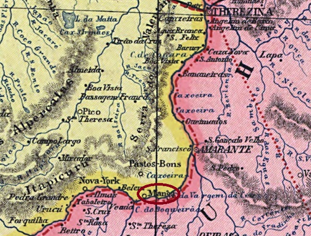
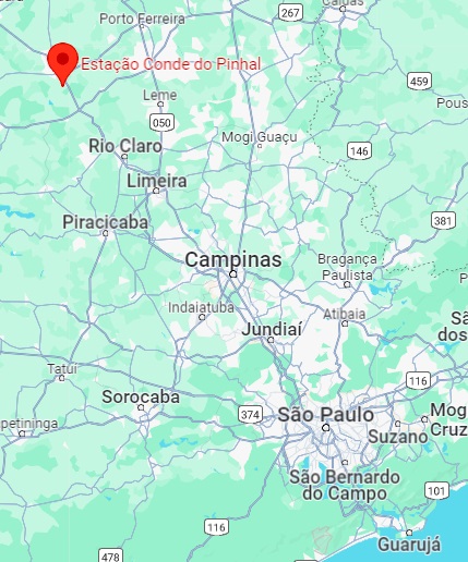
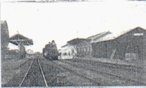
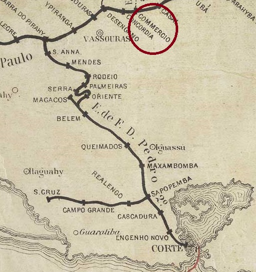
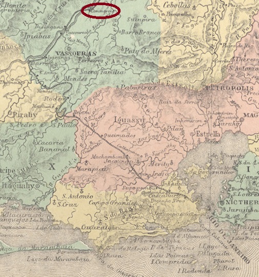
Commercio station was opened in November 1866 by the railway company E.F. D. Pedro II (Central Line) and was located near Vila de Vassouras on the south bank of the Paraíba do Sul, 150 km north-west of the capital Rio de Janeiro. The line was transferred to E.F. Central do Brasil in 1889 and belonged to Rede Ferroviária Federal S.A. from 1975 until its closure in 1996 (estacoesferroviarias.com.br). The tracks are still there today, but the station building is closed.

In 1908 (Photo: Marco Giffoni, on estacoesferroviarias.com.br)
In 2014 (Photo: Jorge Alves Ferreira, on estacoesferroviarias.com.br)

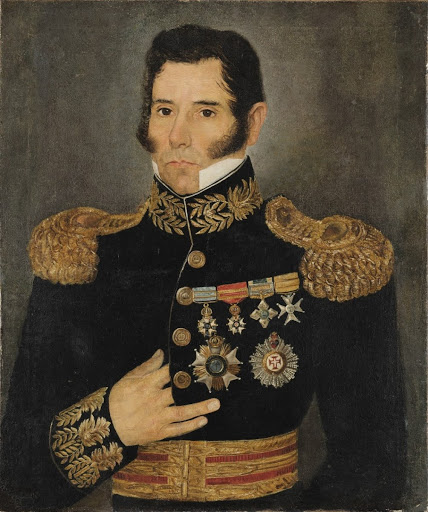
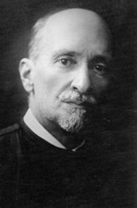
The area around the railway station was declared Distrito de Commercio in October 1910 and renamed Distrito de Sebastião de Lacerda three months later. Born in Vassouras, Sebastião Eurico Gonçalves de Lacerda (1864-1925) was the Brazilian Minister of Transport (1897-8). He is the grandfather of the politician Carlos Lacerda (1914-1977), the railway station was named after Sebastião de Lacerda in August 1931.

Sebastião de Lacerda (Wikipedia)

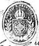
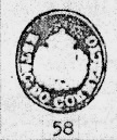
According to consistent sources, a post office had existed at Commercio station since April 1867. R. Koester shows the first postmark CRJ-0350a in Carimbologia XII:

CRJ-0350a (RK) 1867-1876

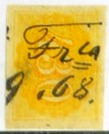
Koester also showed the postmark CRJ-0350b, unfortunately without further details:

CRJ-0350b (RK)

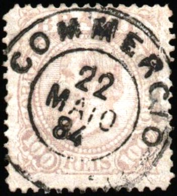
This was followed by the double circle CRJ-0350c (fig. Claudio Coelho):

CRJ-0350c (CC) 1878-1888

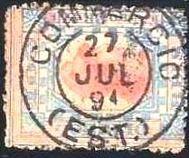
At the end of the Empire, CRJ-0350d also arrived (Fig. agenciaspostais.com.br)

CRJ-0350d (PN) 1889-1897

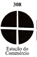
James Dingler and Klerman W. Lopes have illustrated in Mute Cancellations of the Brazil Empire / Carimbos Mudos do Brasil Império (Brazil Philatelic Association, Rio de Janeiro, 2000) a mute cancellation from the Commercio station under no. 308:

 BPA 308, 1876
Atlas do Imperio do Brasil, 1868

Andere Namen: Sebastião de Lacerda (1931)

Der Bahnhof Commercio wurde im November 1866 von der Eisenbahngesellschaft E.F. D. Pedro II (Hauptslinie) eröffnet und lag in der Nähe von Vila de Vassouras am Südufer des Paraíba do Sul, 150 km nordwestlich der Hauptstadt Rio de Janeiro. Die Strecke ging 1889 an die E.F. Central do Brasil über und gehörte von 1975 bis zu ihrer Stilllegung 1996 der Rede Ferroviária Federal S.A. (estacoesferroviarias.com.br). Heute sind die Gleise noch vorhanden, das Bahnhofsgebäude ist geschlossen.

1908 (Foto: Marco Giffoni, auf estacoesferroviarias.com.br)
2014 (Foto: Jorge Alves Ferreira, auf estacoesferroviarias.com.br)

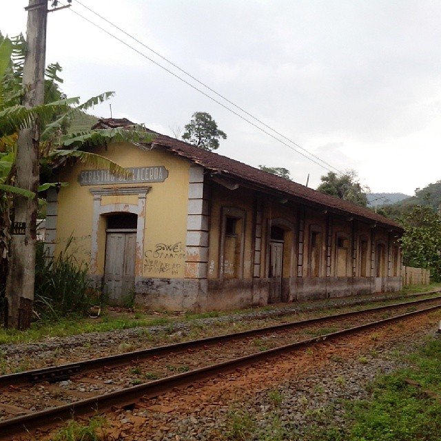
Das Gebiet um den Bahnhof wurde im Oktober 1910 zum Distrito de Commercio erklärt und drei Monate später in Distrito de Sebastião de Lacerda umbenannt. Der in Vassouras geborene Sebastiao Eurico Gonçalves de Lacerda (1864-1925) war brasilianischer Verkehrsminister (1897-8). Er ist der Großvater des Politikers Carlos Lacerda (1914-1977), nach ihm ist der Bahnhof im August 1931 benannt worden.

Sebastião de Lacerda (Wikipedia)

Nach übereinstimmenden Quellen existierte ein Postamt im Bahnhof Commercio seit April 1867. R. Koester zeigt in Carimbologia XII den ersten Poststempel CRJ-0350a:

CRJ-0350a (RK) 1867-1876

Koester zeigte auch den Stempel CRJ-0350b, leider ohne weitere Details:

CRJ-0350b (RK)

Es folgte der Doppelkreis CRJ-0350c (Abb. Claudio Coelho):

CRJ-0350c (CC) 1878-1888

Am Ende des Kaiserreichs kam auch CRJ-0350d (Abb. agenciaspostais.com.br)

CRJ-0350d (PN) 1889-1897

James Dingler und Klerman W. Lopes haben in Mute Cancellations of the Brazil Empire / Carimbos Mudos do Brasil Império (Brazil Philatelic Association, Rio de Janeiro, 2000) einen stummen Stempel aus der Station Commercio unter Nr. 308 abgebildet:

 BPA 308, 1876
Categories
Carimbologia C-D

Colonia, Piauí (CPI-0060)

Carta da Republica dos Estados Unidos do Brazil, 1892

Other names: Manga, Floriano (1897)

The agricultural colony Colonia Rural de S. Pedro de Alcantara was founded in September 1873 on the south bank of the Parnaíba, 250 kilometres south of the provincial capital Teresina. In June 1890, the colony was expanded to include Vila da Manga, a villaged transferred in a region characterised by drought and poverty. In July 1897 it became the town of Floriano.

As R. Koester writes in Carimbologia XI, there had been a post office there since 1882, but no imperial postmark from Colonia in the province of Piauí has yet been found.

Arthur D. Ribeiro: Estado do Piauhy, 1924

Andere Namen: Manga, Floriano (1897)

Die landwirtschaftliche Kolonie Colonia Rural de S. Pedro de Alcantara wurde im September 1873 am Südufer des Parnaíba, 250 km südlich der Provinzhauptstadt Teresina, gegründet. Im Juni 1890 wurde die Kolonie um die Vila da Manga erweitert, die in einer von Trockenheit und Armut geprägten Region dorthin verlegt worden war. Im Juli 1897 wurde daraus die Stadt Floriano.

Wie R. Koester in Carimbologia XI schreibt, gab es dort seit 1882 ein Postamt, aber bisher wurde kein kaiserlicher Poststempel aus Colonia in der Provinz Piauí gefunden.

Categories
Carimbologia C-D

Colonia Leopoldina, Bahia (CBA-0295)

Villiers de l’Ile Adam: Carta (…) da Provincia da Bahia, 1848

Other names: Helvécia (1938)

Colonia Leopoldina was a colony of immigrants from Germany and Switzerland from 1818, located around Vila de Viçosa on the south bank of the Peruípe do Norte, about 1000 kilometres south of the provincial capital Salvador da Bahia. In June 1931 the village was incorporated as a district into the Município de Mucuri, since November 1938 it has been called Helvécia and since July 1962 Helvécia has been a district in the Município Nova Viçosa.

As R. Koester writes in Carimbologia XII, there has been a post office there since June 1876. The only imperial postmark to date is CBA-0295a (fig. Felipe Piccinini):

CBA-0295a (FP) 1890ff
Atlas do Imperio do Brasil, 1868

Andere Namen: Helvécia (1938)

Colonia Leopoldina war ab 1818 eine Kolonie von Einwanderern aus Deutschland und der Schweiz, die im Gebiet der Vila de Viçosa am Südufer des Peruípe do Norte, etwa 1000 km südlich der Provinzhauptstadt Salvador da Bahia, lag. Im Juni 1931 wurde der Ort als Distrikt dem Município de Mucuri angegliedert, seit November 1938 heißt er Helvécia und ist seit Juli 1962 ein Distrikt im Município Nova Viçosa.

Wie R. Koester in Carimbologia XII schreibt, gab es dort ein Postamt seit Juni 1876. Der bisher einzige kaiserliche Poststempel ist CBA-0295a (Abb. Felipe Piccinini):

CBA-0295a (FP) 1890ff
Categories
Carimbologia C-D

Colonia Leopoldina, Alagoas (CAL-0095)

Carta Corographica da Provincia de Pernambuco, 1880

Other names: Leopoldina

From November 1850 to June 1867, Colonia Leopoldina was a military colony of the Vila de Porto Calvo on the south bank of the Jacuípe River on the provincial border with Pernambuco, 110 kilometres north of the provincial capital Maceió. After the colony was closed, the village fell into disrepair until it was declared a Freguesia named Leopoldina in June 1889. In July 1901 it became a Vila and in June 1923 a town. The município has been called Colônia Leopoldina again since December 1943.

As Aldo Cardoso writes in Contribuição para a História dos Correios de Alagoas (Maceió, 1969), there was a post office there from June 1870. The only imperial postmark to date has yet to be definitively confirmed. CAL-0095a (illustration from the Internet) could also has come from the colony of the same name in the province of Bahia:

CAL-0095a (WA) 1887
Atlas do Imperio do Brasil, 1868

Andere Namen: Leopoldina

Colonia Leopoldina war von November 1850 bis Juni 1867 eine Militärkolonie der Vila de Porto Calvo am Südufer des Jacuípe an der Provinzgrenze zu Pernambuco, 110 km nördlich der Provinzhauptstadt Maceió. Nach der Schließung der Kolonie verfiel der Ort, bis er im Juni 1889 zur Freguesia de Leopoldina ernannt wurde. Im Juli 1901 wurde sie zur Vila und im Juni 1923 zur Stadt erhoben. Seit Dezember 1943 heißt der Município wieder Colônia Leopoldina.

Wie Aldo Cardoso in Contribuição para a História dos Correios de Alagoas (Maceió, 1969) schreibt, gab es dort ein Postamt ab Juni 1870. Der bisher einzige kaiserliche Poststempel muss noch endgültig bestätigt werden. Bei CAL-0095a (Abbildung aus dem Internet) besteht noch Verwechslungsgefahr mit der gleichnamigen Kolonie in der Provinz Bahia:

CAL-0095a (WA) 1887
Categories
Carimbologia C-D

Colonia Izabel, Pernambuco (CPE-0210)

Carta Corographica da Provinica de Pernambuco, 880

Other names: Colonia Pimenteiras, Jaqueira (around 1910)

The military colony (Colonia Militar) Pimenteiras existed from 1850 to April 1869 in the area of Vila de Água Preta, 150 kilometres southwest of the provincial capital Recife. After its closure, it was continued as an orphanage colony from 1873 under the name Colonia Orfanológica Isabel until 1894, now on the territory of Vila de Palmares. In December 1904, the village became a district, which was renamed Jaqueira around 1910. Twenty years later, this district was incorporated into the newly founded Município de Maraial. Jaqueira has been an independent município since September 1995.

According to the regional press, there has been a post office in the colony of Pimenteiras since September 1854:

Diario de Pernambuco, 07/10/1854

This agency was probably closed in 1869 with the closure of the colony. It was reopened at the beginning of 1874, now under the name Colonia Isabel:

Diario de Pernambuco, 09.01.1874

The post office was closed again in May 1884 and replaced by the new post office at Jaqueira railway station.

Diario do Brazil/RJ, 31/05/1884

The only imperial postmark to date with the place name Colonia Izabel is CPE-0210b (fig. R. Koester, in Carimbologia XII) and was found on an issue from 1888. It follows that the old postmarks with Colonia Izabel at Jaqueira station were still in use after 1884:

CPE-0210b (RK) 1888ff
Atlas do Imperio do Brasil, 1868

Andere Namen: Colonia Pimenteiras, Jaqueira (um 1910)

Die Militärkolonie (Colonia Militar) Pimenteiras bestand von 1850 bis April 1869 auf dem Gebiet der Vila de Água Preta, 150 km südwestlich der Provinzhauptstadt Recife. Nach ihrer Schließung wurde sie ab 1873 als Waisenhauskolonie unter dem Namen Colonia Orfanológica Isabel weitergeführt und bestand bis 1894, nun auf dem Gebiet der Vila de Palmares. Im Dezember 1904 wurde das Dorf zu einem Bezirk, der um 1910 in Jaqueira umbenannt wurde. Zwanzig Jahre später wurde dieser Bezirk in das neu gegründete Município de Maraial eingegliedert. Seit September 1995 ist Jaqueira ein eigenständiges Município.

Wie aus der regionalen Presse hervorgeht, gab es in der Kolonie Pimenteiras seit September 1854 ein Postamt:

Diario de Pernambuco, 07.10.1854

Diese Agentur wurde wahrscheinlich 1869 mit der Schließung der Kolonie geschlossen. Sie wurde Anfang 1874 wieder eröffnet, nun unter dem Namen Colonia Isabel:

Diario de Pernambuco, 09.01.1874

Das Postamt wurde im Mai 1884 wieder geschlossen und durch das neue Postamt am Bahnhof von Jaqueira ersetzt.

Diario do Brazil/RJ, 31.05.1884

Der bisher einzige kaiserliche Poststempel mit dem Ortsnamen Colonia Izabel ist CPE-0210b (Abb. R. Koester, in Carimbologia XII) und wurde auf einer Ausgabe von 1888 gefunden. Daraus folgt, dass die alten Poststempel mit Colonia Izabel am Bahnhof Jaqueira auch nach 1884 noch verwendet wurden:

CPE-0210b (RK) 1888ff
Categories
Carimbologia C-D

Colonia Itajahy, Santa Catarina (CSC-0060)

Carta da Republica dos Estados Unidos do Brazil, 1892

Other names: S. Luiz Gonzaga, Brusque (1890)

Siehe auch S. Luiz Gonzaga (SSC-0230)

Colonia Itajahy was a settlement of the Vila de Itajahy from December 1860, approx. 100 km north-west of the provincial capital Desterro (today Florianópolis). In July 1874 it was elevated to Freguesia and in March 1881 to Villa de S. Luiz Gonzaga. It was renamed Brusque in January 1890 in memory of Francisco Carlos de Araújo Brusque (1822-1886), who was governor of Santa Catarina from 1859 to 1861.  Brusque has been a town since September 1916.

F.C.A. Brusque (Photo: Andrevruas CC BY-SA 4.0)

As R. Koester writes in Carimbologia XII, there was a post office there from December 1875. So far, no imperial postmarks with the place name Colônia de Itajahy have been found. For postmarks with S. Luiz Gonzaga see SSC-0230.

Estado de Santa Catharina, 1907

Anderer Name: S. Luiz Gonzaga, Brusque (1890)

Siehe auch S. Luiz Gonzaga (SSC-0230)

Colonia Itajahy war ab Dezember 1860 eine Siedlung der Vila de Itajahy, ca. 100 km nordwestlich der Provinzhauptstadt Desterro (heute Florianópolis). Im Juli 1874 wurde sie zur Freguesia und im März 1881 zur Villa de S. Luiz Gonzaga erhoben. Diese wurde im Januar 1890 in Brusque umbenannt, in Erinnerung an Francisco Carlos de Araújo Brusque (1822-1886), der von 1859 bis 1861 Gouverneur von Santa Catarina war.  Seit September 1916 ist Brusque eine Stadt.

F.C.A. Brusque (Foto: Andrevruas CC BY-SA 4.0)

Wie R. Koester in Carimbologia XII schreibt, gab es dort ein Postamt ab Dezember 1875. Bisher wurden keine kaiserlichen Poststempel mit dem Ortsnamen Colônia de Itajahy gefunden. Für Poststempel mit S. Luiz Gonzaga siehe SSC-0230.

Categories
Carimbologia C-D

Colonia (train station/Bahnhof), São Paulo (CSP-0345)

Cia. Paulista de Estradas de Ferro

Other names: Conde do Pinhal (1908)

Colonia station was opened in October 1884 by the railway company E.F. Rio Clarense (main line) and was located in the area of Vila São Carlos, 240 km north-west of the provincial capital of São Paulo.  The line then changed hands three times: in 1888 to the Rio Claro Railway, in 1892 to the Cia. Paulista de Estradas de Ferro and from 1971 until its closure in 1998 it belonged to FEPASA (estacoesferroviarias.com.br). In 1908 the station was renamed Conde de Pinhal. The tracks are still there today, but the new station building built in 1930 is now an abandoned ruin.

In 1918 (Photo: Filemon Peres, on estacoesferroviarias.com.br)
December 2021 (photo: Muricy Tondato, on estacoesferroviarias.com.br)

Philatelist Mário Celso Orsi Jr. writes that there was a post office at the railway station from April 1887. This is confirmed by the regional press:

A Provincia de S. Paulo, 23/04/1887

No imperial postmarks are known to date from Colonia railway station.

Google Maps

Andere Namen: Conde do Pinhal (1908)

Der Bahnhof Colonia wurde im Oktober 1884 von der Eisenbahngesellschaft E.F. Rio Clarense (Hauptstrecke) eröffnet und lag in der Nähe von Vila São Carlos, 240 km nordwestlich der Provinzhauptstadt São Paulo.  Danach wechselte die Strecke dreimal den Besitzer: 1888 an die Rio Claro Railway, 1892 an die Cia. Paulista de Estradas de Ferro und von 1971 bis zur Stilllegung 1998 gehörte sie der FEPASA (estacoesferroviarias.com.br). 1908 wurde der Bahnhof in Conde de Pinhal umbenannt. Heute sind die Gleise noch vorhanden, das 1930 neu erbaute Bahnhofsgebäude ist heute eine verlassene Ruine.

1918 (Foto: Filemon Peres, auf estacoesferroviarias.com.br)
Im Dezember 2021 (Foto: Muricy Tondato, auf estacoesferroviarias.com.br)

Der Philatelist Mário Celso Orsi Jr. schreibt, dass es ab April 1887 ein Postamt am Bahnhof gab. Dies wird von der regionalen Presse bestätigt:

A Provincia de S. Paulo, 23.04.1887

Vom Bahnhof Colonia sind bisher keine kaiserlichen Poststempel bekannt.

Categories
Carimbologia C-D

Colonia Dona Izabel, Rio Grande do Sul (CRS-0115)

Estado do Rio Grande do Sul, 1891

Other names: Colonia Izabel, Bento Gonçalves (1884)

The colony was founded in 1870 around Vila de Triunfo, 120 kilometres north of the provincial capital Porto Alegre, but the first Italian settlers did not arrive until December 1875, when the place was placed under the control of Vila de S. João do Monte Negro. In April 1884 it was renamed Freguesia de Bento Gonçalves in honour of Farroupilha-Caudilho Bento Gonçalves da Silva (1788-1847), the first president of the secessionist República Riograndense, and in October 1890 it was finally elevated to Vila status.

Bento Gonçalves (Wikipedia)

As can be seen from the list of imperial post offices (Tabella das Agencias do Correio do Imperio, Rio de Janeiro, 1885), there had been a post office there since 1881; the oldest postmark to date is DRS-0140a (fig. R. Koester, in Carimbologia XII).

DRS-0140a (RK) 1885-1890

A mute postmark also dates from 1885 (fig. Corinphila Auctions):

1885 (CO)
Carta da Republica dos Estados Unidos do Brazil, 1892

Andere Namen: Colonia Izabel, Bento Gonçalves (1884)

Die Kolonie wurde 1870 auf dem Gebiet der Vila de Triunfo, 120 km nördlich der Provinzhauptstadt Porto Alegre, gegründet, doch die ersten italienischen Siedler kamen erst im Dezember 1875, als der Ort der Vila de S. João do Monte Negro unterstellt wurde. Im April 1884 erfolgte die Umbenennung in Freguesia de Bento Gonçalves zu Ehren von Farroupilha-Caudilhos Bento Gonçalves da Silva (1788-1847), dem ersten Präsidenten der abtrünnigen República Riograndense, und im Oktober 1890 schließlich die Erhebung zur Vila.

Bento Gonçalves (Wikipedia)

Wie aus dem Verzeichnis der kaiserlichen Postämter (Tabella das Agencias do Correio do Imperio, Rio de Janeiro, 1885) hervorgeht, gab es dort seit 1881 ein Postamt; der bisher älteste Poststempel ist DRS-0140a (Abb. R. Koester, in Carimbologia XII).

DRS-0140a (RK) 1885-1890

Aus dem Jahr 1885 stammt auch ein stummer Stempel (Abb. Corinphila Auktionen):

1885 (CO)
Categories
Carimbologia C-D

Colonia Dona Francisca, Santa Catarina (CSC-0055)

Atlas do Imperio do Brasil, 1868

Updatet on January 29, 2024

Other names: Joinville

The original territory of the Propriedade de D. Francisca e Principe de Joinville was a gift from Emperor D. Pedro II to his sister Francisca and her fiancé, the Prince of Joinville, in May 1843. It was not until March 1851 that immigrants from Europe arrived in the colony of Dona Francisca, the centre of which became the settlement of Joinville in 1852. In April 1858, the village was elevated to the Freguesia de S. Francisco Xavier de Joinville, which belonged to the Vila de S. Francisco and was located on the west bank of the Cachoeira, 180 kilometres north of the provincial capital Desterro (today: Florianópolis). Joinville became a vila in March 1866 and a town in May 1877.

Three dates have been found for the creation of the local post office. The first in June 1857, as shown in the report of the Imperial Ministry for the following year:

Relatorio do Ministerio do Imperio/1858, p. 34

Then in May 1859, as R. Koester writes in Carimbologia XII. By 1863, however, the post office had already closed again, as it no longer appears in the list of post offices in the province of Santa Catarina. The third opening was decided in January 1867, this time under the place name Joinville, as can be seen from the directory of imperial post offices (Tabella das Agencias do Correio do Imperio, Rio de Janeiro, 1885).

The oldest postmark is the one with the imperial seal CSC-0055a (fig. R. Koester, op. cit.), as it was found on a colonist’s letter from 1858.

CSC-0055a (RK) 23 July 1858

A handwritten obliteration dated 1868 was found by Felipe Piccinini, and probably comes from there.

1868 (FP)

Then came DSC-0290a, known under no. 1288 by P. Ayres in Catálogo de Carimbos Brasil-Império (S. Paulo, 1937, 1942):

DSC-0290a (P.A. 1288) 1867-1873

It was followed by DSC-0085a, which also exists in blue and brown and is also illustrated in P. Ayres (op. cit.), this time with the no. 1614:

DSC-0085a (P.A. 1614) 1875-1885

The postmark as double circle DSC-0290b (illustr. R. Koester) is puzzling, because around 1886 the place name Dona Francisca was no longer in use:

DSC-0290b (RK) 1886

Postmarks under Joinville will be listed under JSC-0145.

Carta da Republica dos Estados Unidos do Brazil, 1892

Text am 29.01.2024 aktualisiert

Andere Namen: Joinville

Das ursprüngliche Gebiet der Propriedade de D. Francisca e Principe de Joinville war eine Schenkung des Kaisers D. Pedro II. im Mai 1843 an seine Schwester Francisca und ihren Verlobten, den Prinzen von Joinville. Erst im März 1851 kamen Einwanderer aus Europa in die Kolonie Dona Francisca, deren Kern 1852 die Siedlung Joinville wurde. Im April 1858 wurde der Ort zur Freguesia de S. Francisco Xavier de Joinville erhoben, die zur Vila de S. Francisco gehörte und am Westufer des Cachoeira, 180 km nördlich der Provinzhauptstadt Desterro (heute: Florianópolis) lag. Joinville wurde im März 1866 zur Vila und im Mai 1877 zur Stadt erhoben.

Für die Gründung des örtlichen Postamtes wurden drei Daten gefunden. Die erste im Juni 1857, wie aus dem Bericht des kaiserlichen Ministeriums für das folgende Jahr hervorgeht:

Relatorio do Ministerio do Imperio/1858, S. 34

Dann im Mai 1859, wie R. Koester in Carimbologia XII schreibt. Um 1863 war das Postamt jedoch bereits wieder geschlossen, da es im Verzeichnis der Postämter der Provinz Santa Catarina nicht mehr auftaucht. Die dritte Eröffnung wurde im Januar 1867 beschlossen, diesmal unter dem Ortsnamen Joinville, wie aus dem Verzeichnis der kaiserlichen Postämter (Tabella das Agencias do Correio do Imperio, Rio de Janeiro, 1885) hervorgeht.

Der älteste Poststempel ist der mit dem kaiserlichen Siegel CSC-0055a (Abb. R. Koester, op. cit.), da er auf einem Kolonistenbrief aus dem Jahr 1858 gefunden wurde.

CSC-0055a (RK) 23.07.1858

Eine handschriftliche Entwertung von 1868 wurde von Felipe Piccinini gefunden und stammt wahrscheinlich von dort.

1868 (FP)

Danach kam DSC-0290a, bekannt unter der Nr. 1288 durch P. Ayres in Catálogo de Carimbos Brasil-Império (S. Paulo, 1937, 1942):

DSC-0290a (P.A. 1288) 1867-1873

Ihm folgte DSC-0085a, den es auch in blau und braun gibt und der auch bei P. Ayres (op. cit.) abgebildet ist, diesmal mit der Nr. 1614:

DSC-0085a (P.A. 1614) 1875-1885

Der Poststempel als Doppelkreis DSC-0290b (Abb. R. Koester) ist ein Rätsel, denn um 1886 war der Ortsname Dona Francisca längst nicht mehr gebräuchlich:

DSC-0290b (RK) 1886

Poststempel mit dem Ortsnamen Joinville werden unter JSC-0145 aufgeführt.

Categories
Carimbologia C-D

Colonia de Cananea, São Paulo (CSP-0271)

Atlas do Imperio do Brasil, 1868

Other names: Itapitangui

The fascinating history of this failed colonisation project is not yet fully documented. The Colonia de Cananea was founded by imperial decree in August 1861 and was intended to settle “Brazilians, Germans, English and Italians” on the east bank of the river Itapitangui behind the Vila de Cananea, 250 kilometres southwest of the provincial capital São Paulo. According to newspaper reports, however, it was mainly immigrants from Switzerland who settled there, but not for long: due to a lack of infrastructure (roads, schools, hospitals) and financial support, the colony languished and disappeared from the records around 1900. Today, the former colonial area is the rural suburb of Itapitangui in the Município Cananeia.

According to the directory of imperial post offices (Tabella das Agencias do Correio do Imperio, Rio de Janeiro, 1885), the local post office dates to 1869, but as there is no information on postal traffic in the following period, it can be assumed that the agency only started operating later. In October 1896, there were still 12 monthly postal connections between Cananea and Colonia de Cananea:

O Commercio de S. Paulo, 06/10/1896

No imperial postmark from Colonia de Cananea has yet been surely registered.

Provincia de São Paulo, 1879

Andere Namen: Itapitangui

Die faszinierende Geschichte dieses gescheiterten Kolonisierungsprojekts ist noch nicht vollständig dokumentiert. Die Colonia de Cananea wurde durch kaiserliches Dekret im August 1861 gegründet und sollte „Brasilianer, Deutsche, Engländer und Italiener“ am Ostufer des Flusses Itapitangui hinter der Vila de Cananea, 250 km südwestlich der Provinzhauptstadt São Paulo, ansiedeln. Laut Zeitungsberichten waren es jedoch vor allem Einwanderer aus der Schweiz, die sich dort niederließen, allerdings nicht lange: Mangels Infrastruktur (Straßen, Schulen, Krankenhäuser) und finanzieller Unterstützung dümpelte die Kolonie vor sich hin und verschwand um 1900 von den Landkarten. Heute ist das ehemalige Kolonialgebiet der ländliche Vorort Itapitangui im Município Cananeia.

Wie aus dem Verzeichnis der kaiserlichen Postämter (Tabella das Agencias do Correio do Imperio, Rio de Janeiro, 1885) hervorgeht, datiert das örtliche Postamt aus dem Jahr 1869. Da aber für die Folgezeit keine Informationen über Postverkehr vorliegen, ist davon auszugehen, dass die Agentur erst später ihren Betrieb aufnahm. Noch im Oktober 1896 gab es 12 monatliche Postverbindungen zwischen Cananea und Colonia de Cananea:

O Commercio de S. Paulo, 06.10.1896

Bisher wurde kein kaiserlicher Poststempel aus Colonia de Cananea mit Sicherheit identifiziert.