Carta da Republica dos Estados Unidos do Brazil, 1892
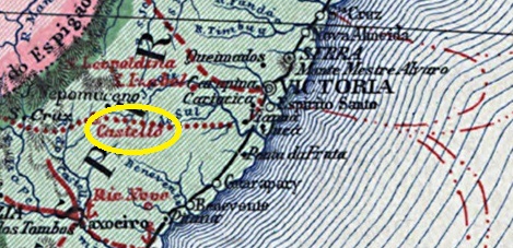
Castello station was opened in September 1887 by the railway company Cia. Lloyd Brasileiro and was located on the west bank of the Castello in the Município Cachoeiro do Itapemirim, 140 km west of the provincial capital Vitória. The railway line was taken over by Espirito Santo e Caravellas Railway Co. Ltd. in 1898 and belonged to E.F. Leopoldina (estacoesferroviarias.com.br) from 1907 until its closure in 1963. Today, the station building has already been demolished and the tracks have been removed. The settlement around the railway station became a district in July 1891 and a Município de Castelo in December 1928.
Around 1940 (estacoesferroviarias.com.br)Around 1970 (Photo: Lauriano G. Fim, on estacoesferroviarias.com.br)
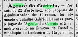
Reinhold Koester in Carimbologia X and Paulo Novaes on agenciaspostais.com.br write that there has been a post office at the railway station since February 1888. However, the first postal agent was introduced in the regional press only in August of that year:
O Espirito Santense, 25/08/1888
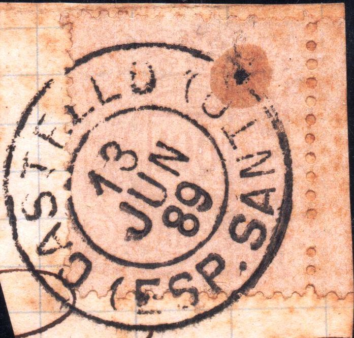
The imperial postmark here is CES-0055a (image from the Internet):
CES-0055a (EB) 1889-1910Instituto Brasileiro de Geografia e Estatística, 1958
Der Bahnhof Castello wurde im September 1887 von der Eisenbahngesellschaft Cia. Lloyd Brasileiro eröffnet und lag am Westufer des Castello im Município Cachoeiro do Itapemirim, 140 km westlich der Provinzhauptstadt Vitória. Die Bahnlinie wurde 1898 von der Espirito Santo e Caravellas Railway Co. Ltd. übernommen und gehörte von 1907 bis zu ihrer Stilllegung 1963 der E.F. Leopoldina (estacoesferroviarias.com.br). Heute ist das Bahnhofsgebäude bereits abgerissen, die Gleise wurden entfernt. Die Siedlung um den Bahnhof wurde im Juli 1891 zum Distrikt und im Dezember 1928 zum Município de Castelo.
Um 1940 (estacoesferroviarias.com.br)Um 1970 (Foto: Lauriano G. Fim, auf estacoesferroviarias.com.br)
Reinhold Koester in Carimbologia X und Paulo Novaes auf agenciaspostais.com.br schreiben, dass es seit Februar 1888 ein Postamt am Bahnhof gab. Der erste Postagent wurde jedoch erst im August des Jahres in der regionalen Presse vorgestellt:
O Espirito Santense, 25.08.1888
Der kaiserliche Poststempel hier ist CES-0055a (Abbildung aus dem Internet):
Bellegard-Niemeyer: Carta Corographica da Provincia do Rio de Janeiro, 1867
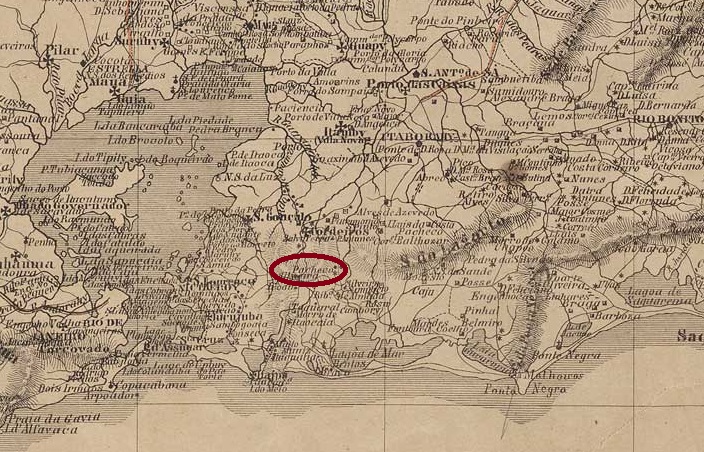
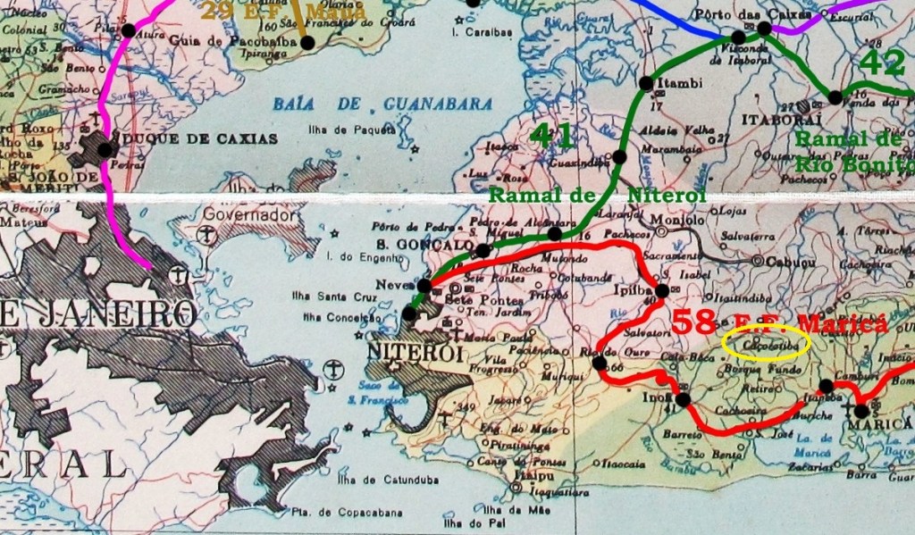
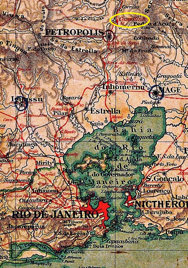
Cassarotiba (also spelt Cassorotiba) is the name of a small mountain range that today lies in the Município Maricá, 50 kilometres east of the capital Rio de Janeiro. There is still a fazenda there today, which may have been the origin of a small settlement.
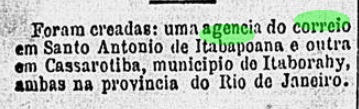
R. Koester writes in Carimbologia X that a post office was established there in January 1885. This is confirmed by the press in Rio:
Gazeta de Noticias, 24/01/1885
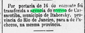
The post office was so insignificant that in the same year it was moved further north to Pachecos, now near the Vila of Itaboraí, as the press also reported:
O Paiz, 18/10/1885
No imperial postmark of Cassarotiba has yet been seen. It must be very rare.
agenciaspostais.com.br
Cassarotiba (heute Cassorotiba geschrieben) ist der Name eines kleinen Gebirges, das im Município Maricá, 50 km östlich der Hauptstadt Rio de Janeiro liegt. Dort befindet sich noch heute eine Fazenda, die möglicherweise der Ursprung einer kleinen Siedlung war.
R. Koester schreibt in Carimbologia X, dass dort im Januar 1885 ein Postamt eingerichtet wurde. Dies wird von der Presse in Rio bestätigt:
Gazeta de Noticias, 24.01.1885
Das Postamt war so unbedeutend, dass es noch im selben Jahr weiter nördlich nach Pachecos, jetzt in der Nähe der Vila von Itaboraí, verlegt wurde, wie die Presse ebenfalls berichtete:
O Paiz, 18.10.1885
Bisher wurde noch kein kaiserlicher Poststempel von Cassarotiba gesehen. Er muss sehr selten sein.
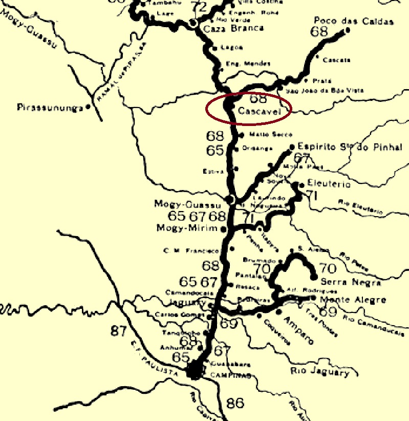
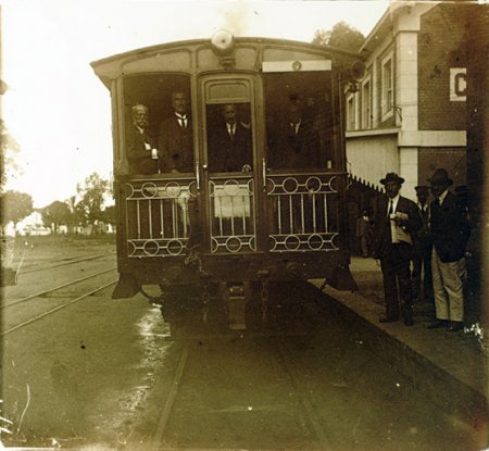
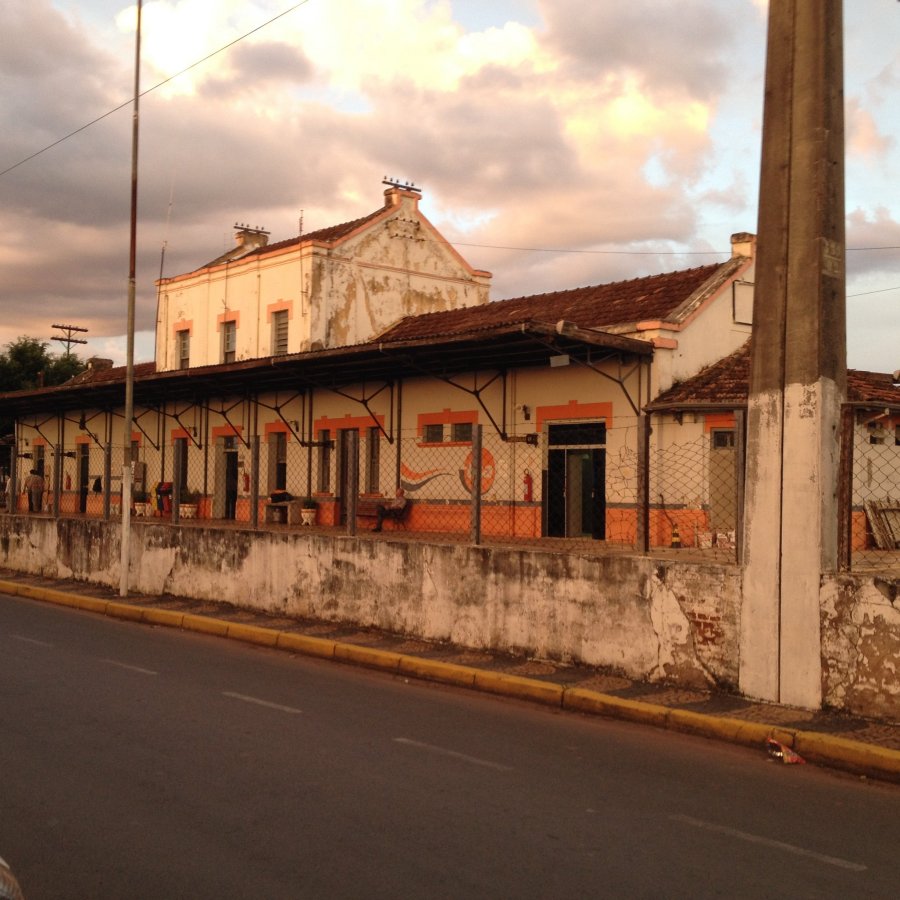
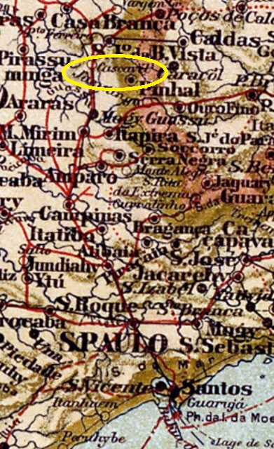
Cascavel station was opened in January 1887 by the railway company Cia. Mogyana (Main Line) and was in the municipality of Vila de S. João da Boa Vista, 190 km north of the provincial capital of São Paulo. Since November 1944, the railway station and the municipality have been called Aguaí. The line was transferred to FEPASA in 1971 and has been operated by Ferrovia Centro-Atlantica (FCA) since 1999. The station building has been a listed building since 2022.
Ca. 1915 (on estacoesferroviarias.com.br)In 2016 (Photo: Ralph Giesbrecht, on estacoesferroviarias.com.br)
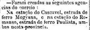
Reinhold Koester writes in Carimbologia X that there has been a post office there since August 1888. This is confirmed by the regional press:
A Provincia de São Paulo, 14/08/1888
No imperial postmarks are known to date from Cascavel railway station.
Mappa Geral do Brasil, 1911
Der Bahnhof Cascavel wurde im Januar 1887 von der Eisenbahngesellschaft Cia. Mogyana (Hauptstrecke) eröffnet und lag in der Gemeinde Vila de S. João da Boa Vista, 190 km nördlich der Provinzhauptstadt São Paulo. Seit November 1944 tragen der Bahnhof und die Gemeinde den Namen Aguaí. Die Strecke ging 1971 an die FEPASA über und wird seit 1999 von der Ferrovia Centro-Atlantica (FCA) betrieben. Seit 2022 steht das Bahnhofsgebäude unter Denkmalschutz.
Ca. 1915 (auf estacoesferroviarias.com.br)2016 (Foto: Ralph Giesbrecht, auf estacoesferroviarias.com.br)
Reinhold Koester schreibt in Carimbologia X, dass es dort seit August 1888 ein Postamt gab. Dies wird von der regionalen Presse bestätigt:
A Provincia de São Paulo, 14.08.1888
Vom Bahnhof Cascavel sind bisher keine kaiserlichen Poststempel bekannt.
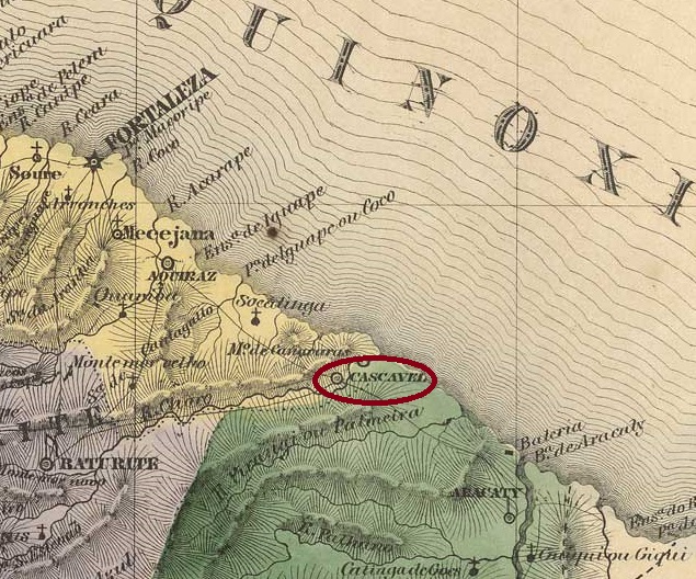
Villiers de l’Ile Adam: Carta (…) da Provincia do Ceara, 1849
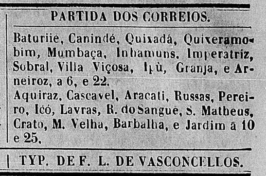
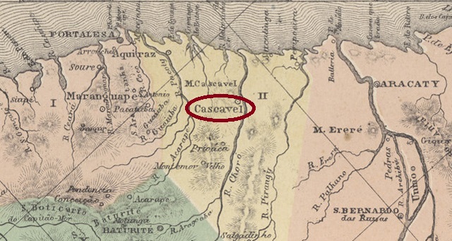
The Freguesia de N. Sra. da Conceição de Cascavel was founded in September 1832 and belonged to the Vila de Aquiraz, near the mouth of the Chorós into the Atlantic Ocean, 65 kilometres south-east of the provincial capital Fortaleza. It was elevated to a vila in May 1833 and to a town in November 1883.
The local post office was established at least three times during the imperial era. The first must have been before 1849, as a regular postal route was already in operation there in January of that year:
O Cearense, 04/01/1849
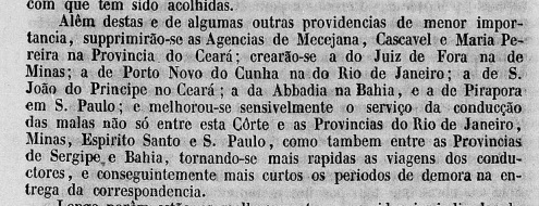
However, this agency was closed in 1851 as it was “of less importance”:
Relatorio do Ministerio do Imperio, 1851, p.27
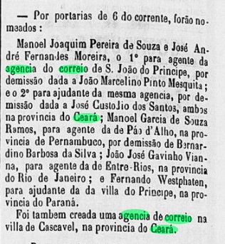
The second opening was decided in April 1864, as reported in the Rio press:
Constitucional/RJ, 09/04/1864
Finally, Nova Monteiro registered in Administrações e Agencias Postaes do Brasil Imperio (Brasil Filatelico/RJ, 1934-5; reprint SPP 1994-1999) a new establishment in March 1865. The only imperial postmark so far is CCE-0100b, as shown by R. Koester in Carimbologia X:
CCE-0100b (RK)Atlas do Imperio do Brasil, 1868
Die Freguesia de N. Sra. da Conceição de Cascavel wurde im September 1832 gegründet und gehörte zur Vila de Aquiraz, nahe der Mündung des Chorós in den Atlantik, 65 km südöstlich der Provinzhauptstadt Fortaleza. Es wurde im Mai 1833 zur Vila und im November 1883 zur Stadt erhoben.
Das örtliche Postamt wurde während der Kaiserzeit mindestens dreimal eingerichtet. Das erste muss vor 1849 gewesen sein, da bereits im Januar dieses Jahres eine regelmäßige Postroute dorthin in Betrieb war:
O Cearense, 04.01.1849
Diese Agentur wurde jedoch 1851 geschlossen, da sie „von geringer Bedeutung“ war:
Relatorio do Ministerio do Imperio, 1851, S.27
Die zweite Eröffnung wurde im April 1864 beschlossen, wie die Presse von Rio berichtete:
Constitucional/RJ, 09.04.1864
Schließlich registrierte Nova Monteiro in Administrações e Agencias Postaes do Brasil Imperio (Brasil Filatelico/RJ, 1934-5; Reprint SPP 1994-1999) eine Neugründung im März 1865. Der bisher einzige kaiserliche Poststempel ist CCE-0100b, wie von R. Koester in Carimbologia X gezeigt:
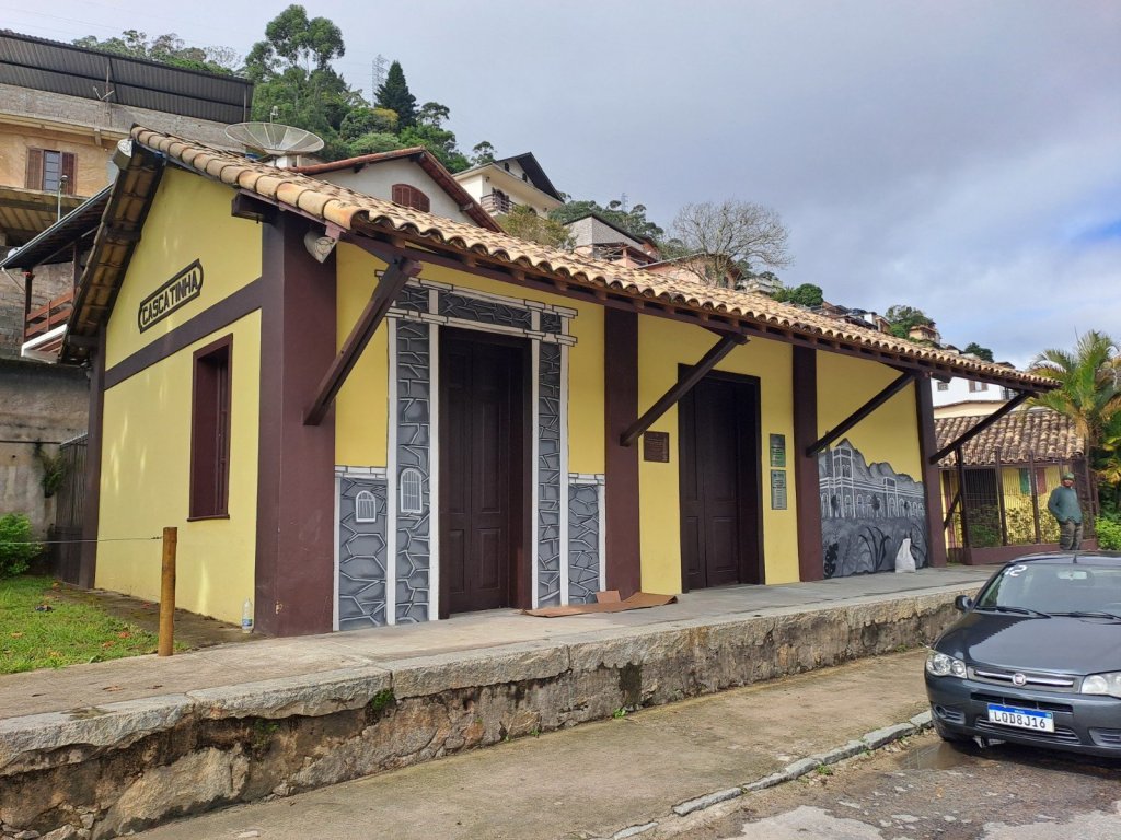
Cascatinha (Little Waterfall) station was opened in February 1886 by the E.F. Príncipe do Grão-Pará railway company and was located on the east bank of the Piabanha in the Vila de Petrópolis region, over 70 km north of the capital Rio de Janeiro. The line belonged to E.F. Leopoldina from 1890 until it was closed. Today, the tracks have disappeared and the station building serves as a museum (estacoesferroviarias.com.br).
In 1905 (Photo: Revista da Semana, on estacoesferroviarias.com.br)In June 2023 (Photo: Renato Ramos, on estacoesferroviarias.com.br)
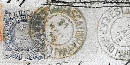
As R. Koester writes in Carimbologia X, there had been a post office at the railway station since 1886. Three postmarks were found for the 19th century. CRJ-0325a (agenciaspostais.com.br) is the oldest one and bears internal dates from 1887 to 1889:
CRJ-0325a (PN) 1887-1889
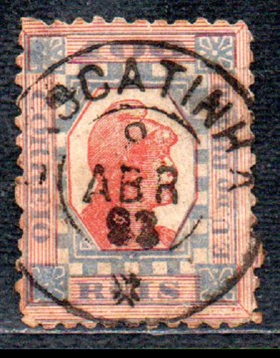
R. Koester showed the successor postmark CRJ-0325b in Carimbologia X:
CRJ-0325b (RK) 1889
CRJ-0325c also appeared at the beginning of the Republic (picture: Luiz C. Fritzen):
CRJ-0325c (LCF) 1893-1901agenciaspostais.com.br
Der Bahnhof Cascatinha (Kleiner Wasserfall) wurde im Februar 1886 von der Eisenbahngesellschaft E.F. Príncipe do Grão-Pará eröffnet und lag am Ostufer des Piabanha in der Region Vila de Petrópolis, über 70 km nördlich der Hauptstadt Rio de Janeiro. Die Strecke gehörte von 1890 bis zu ihrer Stilllegung der E.F. Leopoldina. Heute sind die Gleise verschwunden, das Bahnhofsgebäude dient als Museum (estacoesferroviarias.com.br).
1905 (Foto: Revista da Semana, auf estacoesferroviarias.com.br)Im Juni 2023 (Foto: Renato Ramos, auf estacoesferroviarias.com.br)
Wie R. Koester in Carimbologia X schreibt, gab es seit 1886 ein Postamt am Bahnhof. Für das 19. Jahrhundert wurden drei Poststempel gefunden. CRJ-0325a (agenciaspostais.com.br) ist der älteste und trägt interne Daten von 1887 bis 1889:
CRJ-0325a (PN) 1887-1889
R. Koester zeigte in Carimbologia X den Nachfolgestempel CRJ-0325b:
CRJ-0325b (RK) 1889
Zu Beginn der Republik erschien auch CRJ-0325c (Abb. Luiz C. Fritzen):
Estações Ferroviarias (…) do Rio de Janeiro, São Paulo e Minas Geraes, 1880
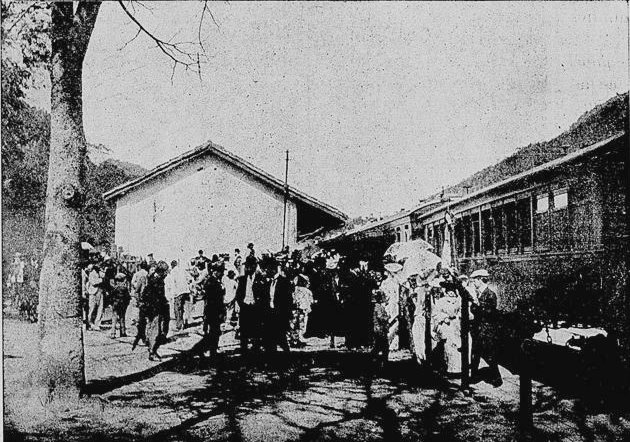
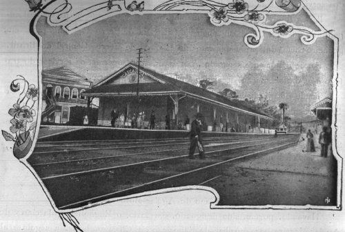
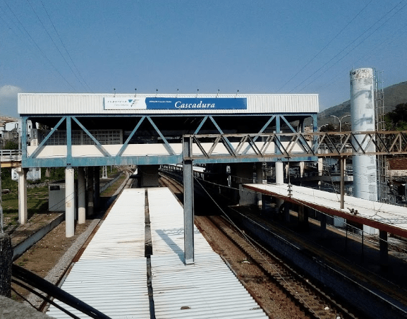
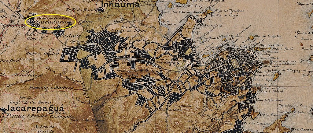
Cascadura station (= hard rind) was opened in March 1858 by the railway company E.F. D. Pedro II (Center Line) and is located just under 20 km west of the city centre of Rio de Janeiro. The line was transferred to E.F. Central do Brasil in 1889, to Rede Ferroviária Federal S.A. in 1975 and has been operated by the Supervia consortium (estacoesferroviarias.com.br) since 1997.
1908 (Photo: M.F. Figueira, Memória Histórica da EFCB, on estacoesferroviarias.com.br)2022 (Photo: Renato-Simões, on agenciaspostais.com.br)
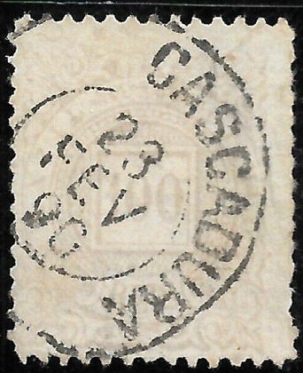
As Nova Monteiro writes in Administrações e Agencias Postaes do Brasil Imperio (Brasil Filatelico/RJ, 1934-5; reprint SPP 1994-1999), there had been a post office at the railway station since May 1862, making Cascadura the oldest railway station post office in Brazil. Three postmarks were found for the 19th century, unfortunately not the oldest one. The double circle CMN-0085b (fig. R. Koester, in Carimbologia X) shows a date of 1885:
CMN-0085b (RK) 1885
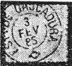
The successor CMN-0085c (fig. from the Internet) appears to be a variant in which both the inscription EST. DE and the ornament at the bottom have been removed:
CMN-0085c (EB) 1888ff-1890
CMN-0085d was added later (image from the Internet):
CMN-0085d (EB) 1883ff-1899Mappa do Municipio Neutro, ca. 1880
Der Bahnhof Cascadura (= Harte Schale) wurde im März 1858 von der Eisenbahngesellschaft E.F. D. Pedro II (Hauptstrecke) eröffnet und liegt knapp 20 km westlich des Stadtzentrums von Rio de Janeiro. Die Strecke ging 1889 an die E.F. Central do Brasil, 1975 an die Rede Ferroviária Federal S.A. über und wird seit 1997 vom Konsortium Supervia (estacoesferroviarias.com.br) betrieben.
1908 (Foto: M.F. Figueira, Memória Histórica da EFCB, auf estacoesferroviarias.com.br)2022 (Foto: Renato-Simões, auf agenciaspostais.com.br)
Wie Nova Monteiro in Administrações e Agencias Postaes do Brasil Imperio (Brasil Filatelico/RJ, 1934-5; Nachdruck SPP 1994-1999) schreibt, gab es am Bahnhof seit Mai 1862 ein Postamt, womit Cascadura das älteste Bahnhofspostamt Brasiliens wäre. Für das 19. Jahrhundert wurden drei Poststempel gefunden, leider nicht der älteste. Der Doppelkreis CMN-0085b (Abb. R. Koester, in Carimbologia X) zeigt ein Datum von 1885:
CMN-0085b (RK) 1885
Der Nachfolger CMN-0085c (Abb. aus dem Internet) scheint eine Variante zu sein, bei der sowohl die Inschrift EST. DE und die Verzierung unten entfernt wurden:
CMN-0085c (EB) 1888ff-1890
Später kam CMN-0085d hinzu (Abbildung aus dem Internet):
Estações Ferroviarias (…) do Rio de Janeiro, São Paulo e Minas Geraes, 1880
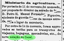
Cazal station (also spelt Casal) is said to have been inaugurated in October 1867 by the E.F.D. Pedro II railway company (Center Line), although Paulo Novaes (agenciaspostais.com.br) assumes that the inauguration did not take place until the end of 1876. He refers to a newspaper article from November 1876, which mentions a “new” Cazal railway station:
Diario do Rio de Janeiro,15 Nov. 1876
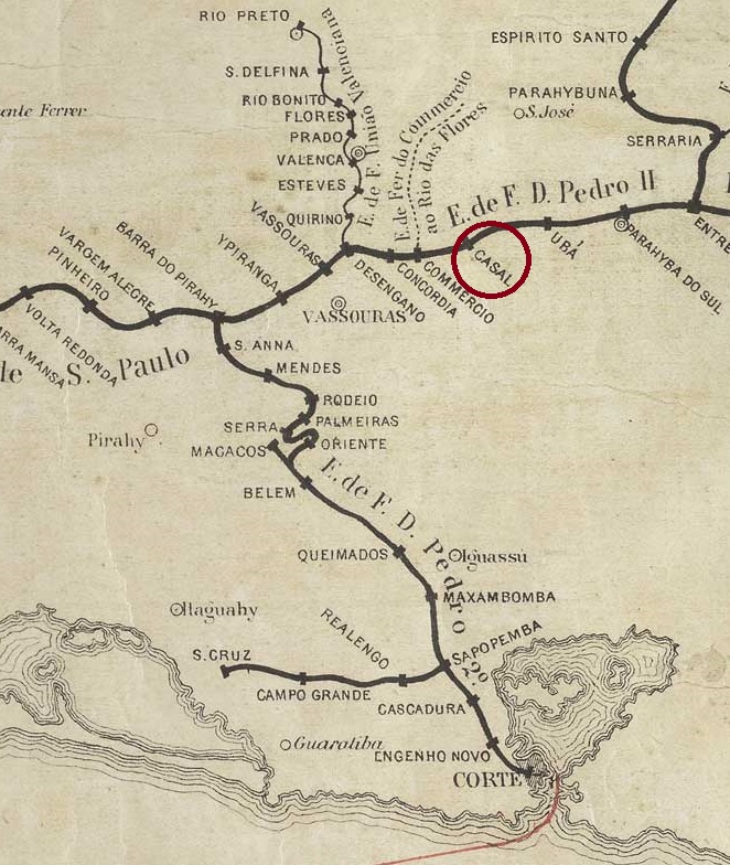
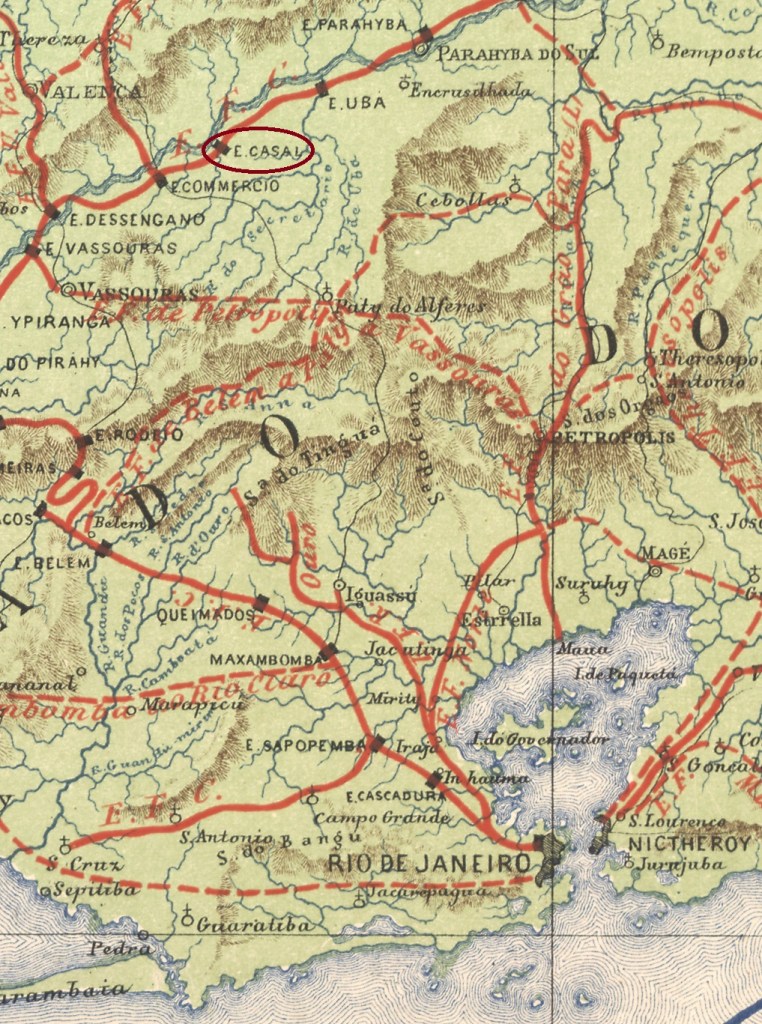
In any case, the station was in the Vila de Vassouras area, 130 kilometres north of the capital Rio de Janeiro, named after a fazenda in the region. The line went to E. F. Central do Brasil in 1889 and belonged to Rede Ferroviária Federal S.A. (estacoesferroviarias.com.br) from 1975 until it was closed in 1996. The tracks are still there today, but the station building has long since been demolished.
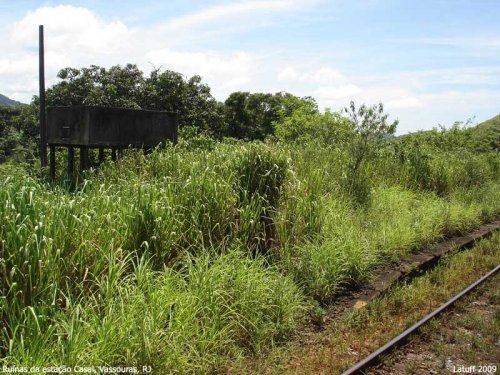
In 2009 (Photo: Carlos Latuff on estacoesferroviarias.com.br)
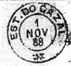
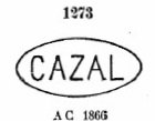
According to the Directory of Imperial Post Offices (Tabella das Agencias do Correio do Imperio, Rio de Janeiro, 1885), there had been a post office at the station since 1876, and three postmarks were found for the 19th century. The first, CRJ-0320a, was used at least until 1878 and is recorded in Paulo Ayres’ Catálogo de Carimbos Brasil-Império (S. Paulo, 1937, 1942) under the number 1273:
CRJ-0320a (P.A. 1273) 1876ff-1878ff
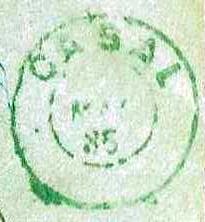
This is followed by CRJ-0320b, the only example of which (agenciaspostais.com.br) is dated 1885:
CRJ-0320b (PN) 1885
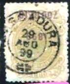
Finally, at the end of the Empire, CRJ-0320c (fig. R. Koester, in Carimbologia X) was added:
CRJ-0320c (RK) 1888-1895Estrada de Ferro Central do Brasil, 1890
Der Bahnhof Cazal (auch Casal geschrieben) soll im Oktober 1867 von der Eisenbahngesellschaft E.F.D. Pedro II (Hauptstrecke) eingeweiht worden sein, obwohl Paulo Novaes (agenciaspostais.com.br) vermutet, dass die Einweihung erst Ende 1876 stattfand. Er beruft sich dabei auf einen Zeitungsartikel vom November 1876, in dem von einem „neuen“ Bahnhof Cazal die Rede ist:
Diario do Rio de Janeiro,15.11.1876
Jedenfalls lag der Bahnhof in der Gegend von Vila de Vassouras, 130 km nördlich der Hauptstadt Rio de Janeiro, und wurde nach einer Fazenda der Region benannt. Die Strecke ging 1889 an die E. F. Central do Brasil und gehörte von 1975 bis zu ihrer Stilllegung 1996 der Rede Ferroviária Federal S.A. (estacoesferroviarias.com.br). Heute sind die Gleise noch vorhanden, das Bahnhofsgebäude ist längst abgerissen.
2009 (Foto: Carlos Latuff auf estacoesferroviarias.com.br)
Wie aus dem Verzeichnis der kaiserlichen Postämter (Tabella das Agencias do Correio do Imperio, Rio de Janeiro, 1885) hervorgeht, gab es im Bahnhof seit 1876 ein Postamt, für das 19. Jahrhundert wurden drei Poststempel gefunden. Der erste, CRJ-0320a, wurde mindestens bis 1878 verwendet und ist in Paulo Ayres‘ Catálogo de Carimbos Brasil-Império (S. Paulo, 1937, 1942) unter der Nummer 1273 verzeichnet:
CRJ-0320a (P.A. 1273) 1876ff-1878ff
Es folgt CRJ-0320b, dessen einziges Exemplar (agenciaspostais.com.br) 1885 datiert ist:
CRJ-0320b (PN) 1885
Am Ende des Kaiserreichs kam schließlich CRJ-0320c (Abb. R. Koester, in Carimbologia X) hinzu:
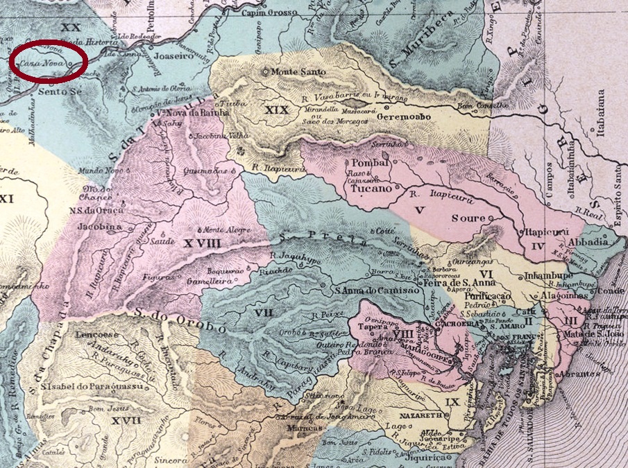
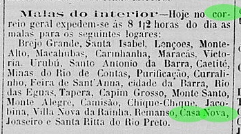
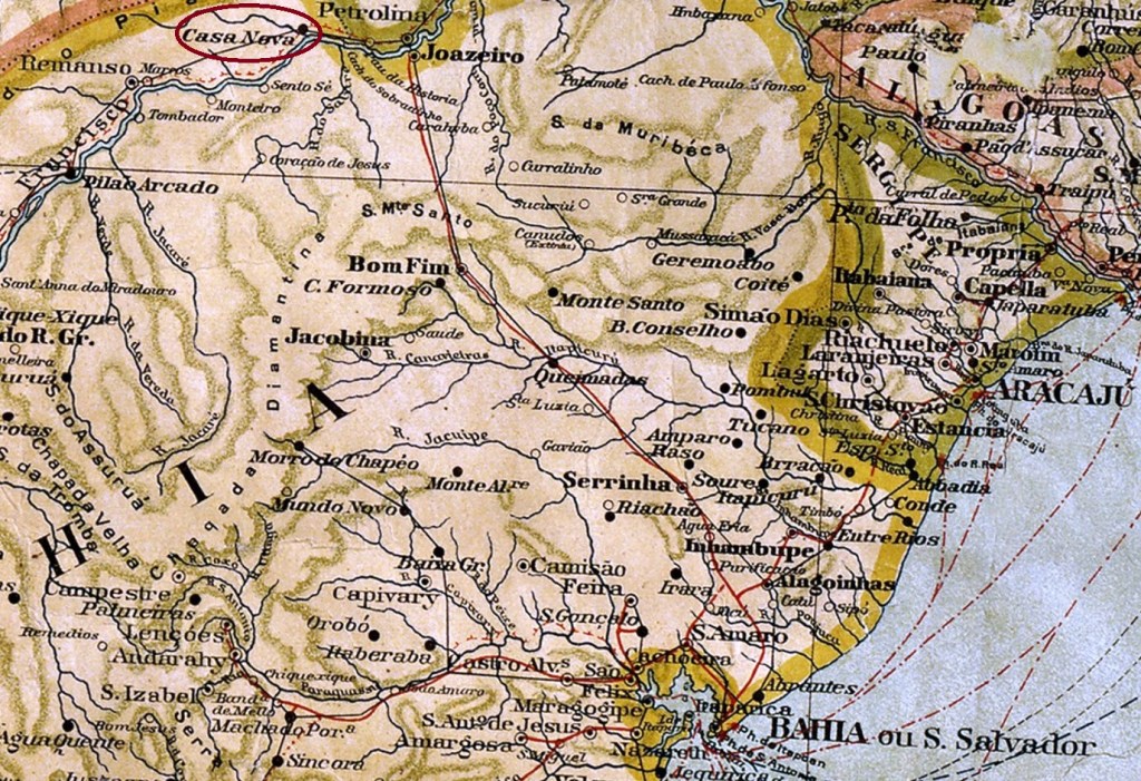
The locality of São José do Riacho da Casa Nova was founded in 1873 as part of the Vila Remanso de Pilão Arcado and is located approximately 570 kilometres northwest of the provincial capital Salvador da Bahia. In 1879 it became an independent município, São José da Casa Nova, which simplified its name to Casa Nova in 1931. And Casa Nova was not the famous Venetian seducer, but a tributary of the Rio São Francisco, which gave the town its name. A dam built by the Brazilian military dictatorship in 1976 near Sobradinho on the São Francisco flooded the entire region and relocated at least four historic communities: Pilão Arcado, Remanso, Sento Sé and Casa Nova.
The report of the Provisional Government Council of Bahia for 1877 mentions a post office that had been established the year before:
Relatorio do Conselho Interino do Governo da Bahia, 1877
This is again confirmed by the regional press:
O Monitor, November 30, 1876
We are eagerly awaiting the first imperial stamp from Casa Nova. Hopefully it will have survived the flooding.
Mappa Geral do Brasil, 1911
Siehe auch Riacho da Casa Nova (RBA-0595)
Die Gemeinde São José do Riacho da Casa Nova wurde 1873 als Teil der Vila Remanso de Pilão Arcado gegründet und liegt ca. 570 km nordwestlich der Provinzhauptstadt Salvador da Bahia. Im Jahre 1879 wurde es ein eigenständiges Município, São José da Casa Nova, das 1931 seinen Namen in Casa Nova vereinfachte. Und Casa Nova war nicht der berühmte venezianische Verführer, sondern ein Nebenfluss des Rio São Francisco, der dem Ort seinen Namen gab. Ein 1976 von der brasilianischen Militärdiktatur errichteter Staudamm bei Sobradinho am São Francisco überflutete die gesamte Region und siedelte mindestens vier historische Gemeinden um: Pilão Arcado, Remanso, Sento Sé und auch Casa Nova.
Der Bericht des provisorischen Regierungsrates von Bahia für 1877 erwähnt ein Postamt, das im Jahr zuvor eingerichtet worden war:
Relatorio do Conselho Interino do Governo da Bahia, 1877
Dies wird wiederum von der regionalen Presse bestätigt:
O Monitor, November 30, 1876
Wir sind gespannt auf den ersten kaiserlichen Stempel von Casa Nova. Hoffentlich hat er die Überschwemmung überstanden.
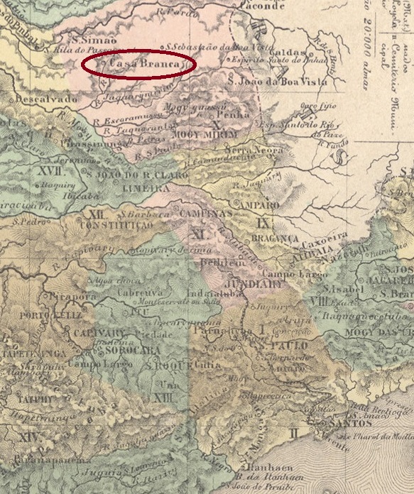
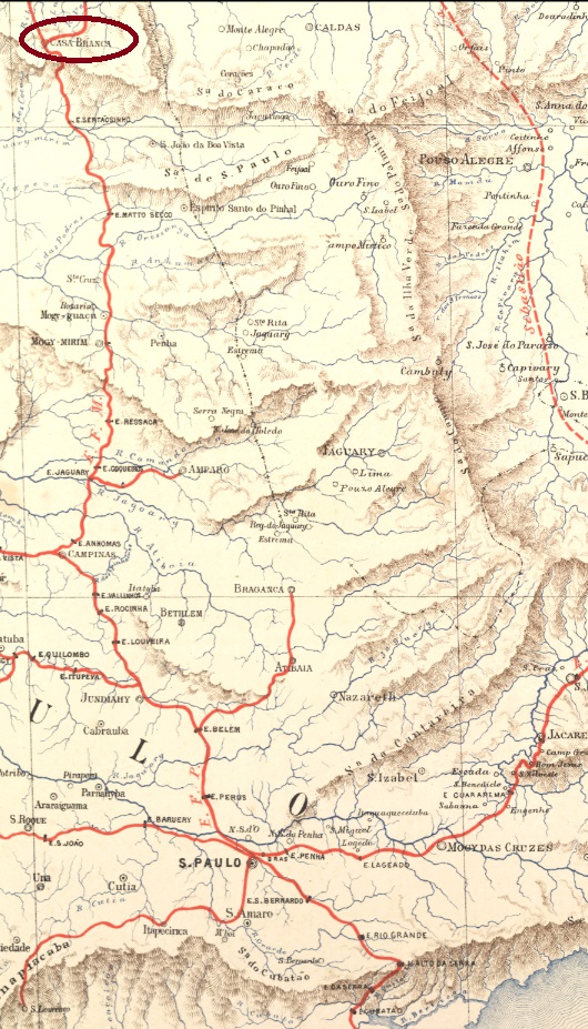
The Freguesia de N. Sa. das Dores de Casa Branca was founded in March 1814; it belonged to the Vila de Mogy Mirim and was located 230 kilometres north of the later provincial capital São Paulo. In February 1841 it became a Vila and in March 1872 a city.
Nova Monteiro writes in Administrações e Agencias Postaes do Brasil Imperio (Brasil Filatelico/RJ, 1934-5; reprint SPP 1994-1999) that there had been a post office there since February 1832. In the directory of imperial post offices (Tabella das Agencias do Correio do Imperio, Rio de Janeiro, 1885), the agency is listed as having been founded in 1846.
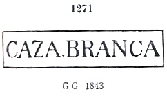
The oldest postmark to date is CSP-0325a, which also occurs in the colours brown, sepia and blue and was already registered by P. Ayres in the Catálogo de Carimbos Brasil-Império (S. Paulo, 1937, 1942) under no. 1271:
CSP-0325a (P.A. 1271) 1843ff-1869ff
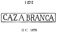
Its successor is very similar to it. CSP-0325b also exists in blue and has the no. 1272 in P. Ayres (op.cit.), but the dot between CAZA and BRANCA is missing:
CSP-0325b (P.A. 1272) 1866ff-1878ff
Then came the double circle CSP-0325c, which is illustrated by P. Ayres on p. 121:
CSP-0325c (P.A. p. 121) 1876-1888
A short time later, the French type CSP-0325d appeared (illustrated by Roberto Assef Jr.):
CSP-0325d (RA) 1884-1896
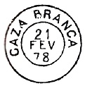
In the late imperial period, the type CSP-0325e (picture from the Internet) was also used:
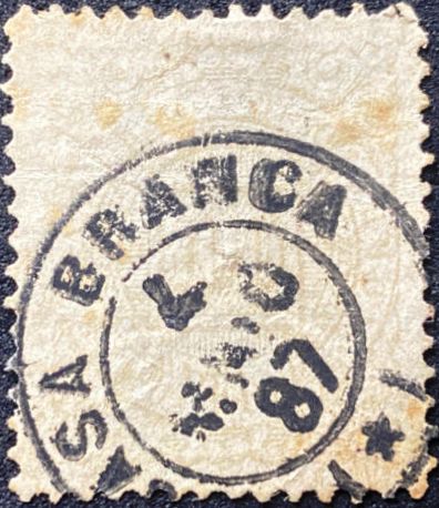
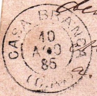
CSP-0325e (EB) 1889-1898
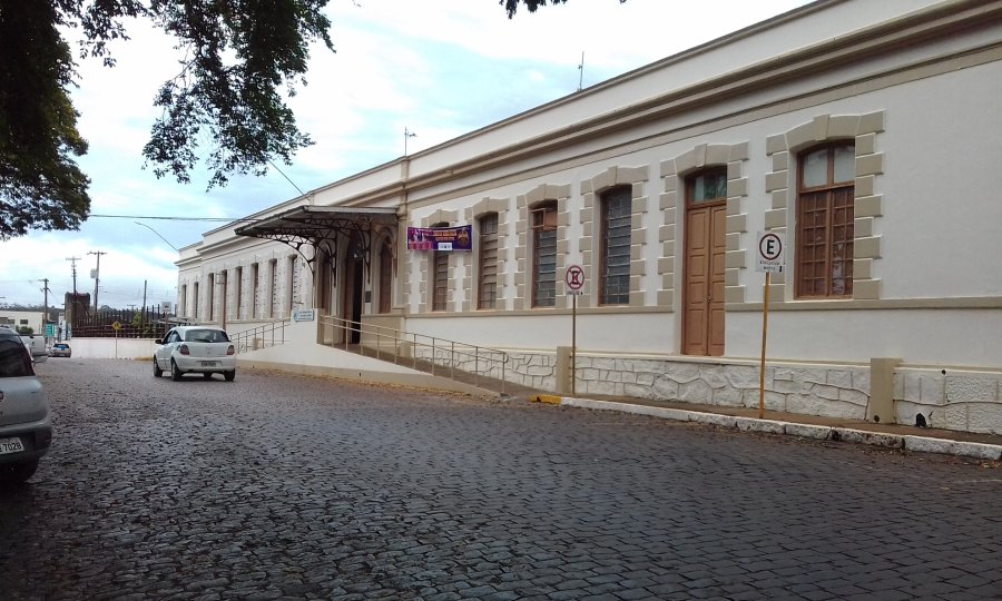
In January 1878, a railway station of the Cia. Mogyana railway company (main line) was opened in Casa Branca. The line was transferred to FEPASA in 1971 and was in operation until 1998. The tracks are still there today and the building serves as the town hall.
ca. 1910 (Photo: Album Mogyana on estacoesferroviarias.com.br)In 2018 (Photo: Silvio Rizzo on estacoesferroviarias.com.br)
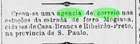
The station post office was opened in April 1884, as reported in the Rio press:
Brazil/RJ, 08.04.1884
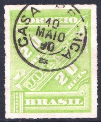
As no station postmark can yet be seen, the wagon postmark (Correio Ambulante) was probably used. First to appear was CSP-0330a (José A. Junges Coll.) with dates from 1885 to 1888:
CSP-0330a (JJ) 1885-1888
Its successor is CSP-0330b, as shown by R. Koester (Carimbologia X):
CSP-0330b (RK) 1888-1889E. F. Central do Brasil, 1890
Die Freguesia de N. Sa. das Dores de Casa Branca wurde im März 1814 gegründet; sie gehörte zur Vila de Mogy Mirim und lag 230 km nördlich der späteren Provinzhauptstadt São Paulo. Im Februar 1841 wurde es zur Vila und im März 1872 zur Stadt erhoben.
Nova Monteiro schreibt in Administrações e Agencias Postaes do Brasil Imperio (Brasil Filatelico/RJ, 1934-5; Reprint SPP 1994-1999), dass es dort seit Februar 1832 ein Postamt gab. Im Verzeichnis der kaiserlichen Postämter (Tabella das Agencias do Correio do Imperio, Rio de Janeiro, 1885) wird die Agentur mit dem Gründungsjahr 1846 aufgeführt.
Der bisher älteste Poststempel ist CSP-0325a, der auch in den Farben Braun, Sepia und Blau vorkommt und bereits von P. Ayres im Catálogo de Carimbos Brasil-Império (S. Paulo, 1937, 1942) unter Nr. 1271 registriert wurde:
CSP-0325a (P.A. 1271) 1843ff-1869ff
Sein Nachfolger ist ihm sehr ähnlich. CSP-0325b kommt ebenfalls in blau vor und hat die Nr. 1272 bei P. Ayres (op.cit.), aber der Punkt zwischen CAZA und BRANCA fehlt hier:
CSP-0325b (P.A. 1272) 1866ff-1878ff
Danach kam der Doppelkreis CSP-0325c, der bei P. Ayres auf S. 121 abgebildet ist:
CSP-0325c (P.A. S. 121) 1876-1888
Kurze Zeit später erschien der französische Typ CSP-0325d (Abb. Roberto Assef Jr.):
CSP-0325d (RA) 1884-1896
In der späten Kaiserzeit wurde auch der Typ CSP-0325e (Bild aus dem Internet) verwendet:
CSP-0325e (EB) 1889-1898
Im Januar 1878 wurde in Casa Branca ein Bahnhof der Eisenbahngesellschaft Cia. Mogyana (Hauptstrecke) eröffnet. Die Strecke ging 1971 an die FEPASA über und war bis 1998 in Betrieb. Heute sind die Gleise noch vorhanden, das Gebäude dient als Rathaus.
ca. 1910 (Foto: Album Mogyana, auf estacoesferroviarias.com.br)2018 (Foto: Silvio Rizzo, auf estacoesferroviarias.com.br)
Das Bahnhofspostamt wurde im April 1884 eröffnet, wie die Presse in Rio berichtete:
Brazil/RJ, 08.04.1884
Da noch kein Bahnhofspoststempel zu sehen ist, wurde vermutlich der Wagenstempel (Correio Ambulante) verwendet. Zuerst erschien CSP-0330a (Samml. José A. Junges) mit Daten von 1885 bis 1888:
CSP-0330a (JJ) 1885-1888
Sein Nachfolger ist CSP-0330b, wie er von R. Koester (Carimbologia X) gezeigt wurde:
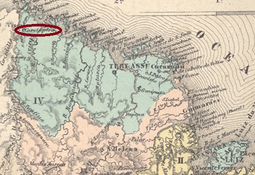
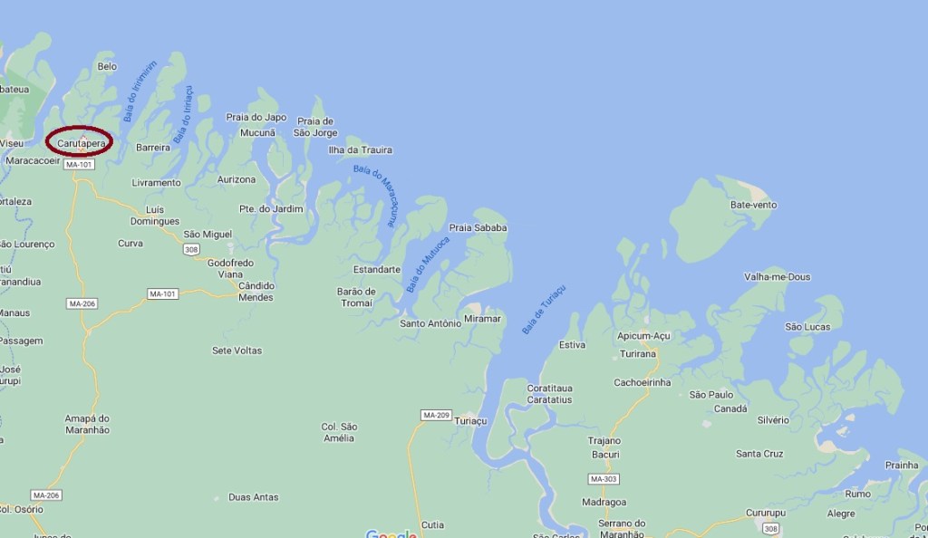
From 1861, Carutapera was a settlement on the south bank of the Arapiranga, which belonged to the Vila de Tury-Assú and was located 350 kilometres northwest of the provincial capital of São Luís. In July 1873 it became the Freguesia de S. Sebastião de Carutapera, in May 1886 a Vila, in April 1931 it was downgraded to a district of Turiaçu, and since June 1935 Carutapera has been an independent Município. The place name is of indigenous origin and means abandoned settlement.
As R. Koester writes in Carimbologia IX, there has been a post office in the village since December 1882. No imperial postmark from Carutapera is known to date.
Google Maps
Carutapera war ab 1861 eine Siedlung am Südufer des Arapiranga, die zur Vila de Tury-Assú gehörte und 350 km nordwestlich der Provinzhauptstadt São Luís lag. Im Juli 1873 wurde es zur Freguesia de S. Sebastião de Carutapera, im Mai 1886 zur Vila, im April 1931 wurde es zum Distrikt von Turiaçu herabgestuft und seit Juni 1935 ist Carutapera ein eigenständiger Município. Der Ortsname ist indigenen Ursprungs und bedeutet verlassene Siedlung.
Wie R. Koester in Carimbologia IX schreibt, gab es seit Dezember 1882 ein Postamt am Ort. Bisher ist kein kaiserlicher Poststempel aus Carutapera bekannt.