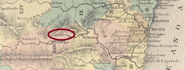
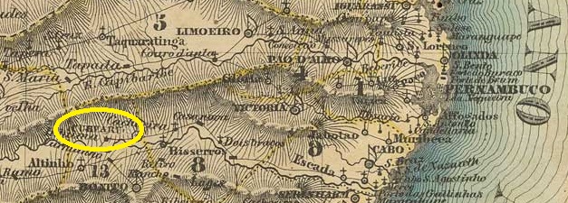
The Freguesia de N. Sra. da Conceição de Caruaru (also spelt Caruru) was founded in 1844, belonged to the Vila de Bonito and was located on the north bank of the Ipojuca, 130 kilometres west of the provincial capital Recife. It became a Vila in August 1848 and a town in May 1878.
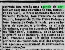
There had been a post office on place since June 1850, as can be seen from the regional press:
Diario de Pernambuco, 11/07/1850
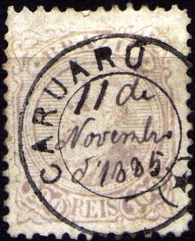
The first imperial postmark has not yet been found. Its successor would be the French type CPE-0175b (fig. Claudio Coelho), which has been seen with dates from 1885 to 1889:
CPE-0175b (CC) 1885-1889
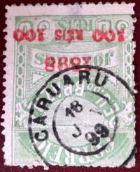
Towards the end of the 19th century, CPE-0175c also appeared (illustration from the Internet):
CPE-0175c (EB) 1893-1899Villiers de l’Ile Adam: Carta (…) das Provincias de Pernambuco, Alagoas e Sergipe, 1848
Die Freguesia de N. Sra. da Conceição de Caruaru (auch Caruru geschrieben) wurde 1844 gegründet, gehörte zur Vila de Bonito und lag am Nordufer des Ipojuca, 130 km westlich der Provinzhauptstadt Recife. Im August 1848 wurde es zur Vila und im Mai 1878 zur Stadt erhoben.
Seit Juni 1850 gab es dort ein Postamt, wie aus der regionalen Presse hervorgeht:
Diario de Pernambuco, 11.07.1850
Der erste kaiserliche Poststempel ist noch nicht gefunden worden. Sein Nachfolger wäre der französische Typ CPE-0175b (Abb. Claudio Coelho), der mit Daten von 1885 bis 1889 gesehen wurde:
CPE-0175b (CC) 1885-1889
Gegen Ende des 19. Jahrhunderts erschien auch CPE-0175c (Abb. aus dem Internet):
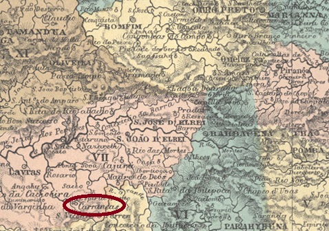
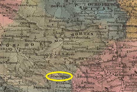
The parish of N. Sra. da Conceição de Carrancas was founded in July 1813 near the north bank of the Capivari River belonging to Vila de Turvo, 240 kilometres southwest of the future provincial capital of Ouro Preto. In 1878 it became a freguesia and in September 1909 a district of the Município de Lavras, which became the Município de S. Francisco de Sales in December 1938. Carrancas has been a separate município since December 1849. The peculiar place name (frown or grimace) is reminiscent of the rock formations in the area.
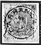
R. Koester (Carimbologia IX) and Paula Sobrinho (História Postal de Minas Gerais, Belo Horizonte, 1997) agree that there has been a post office there since September 1880. The only imperial postmark to date is CMG-0695a, as presented by Koester (op. cit.):
CMG-0695a (RK) 1885Villiers de l’Ile Adam: Carta (..) da Provincia de Minas Geraes, 1849
Die Pfarrei N. Sra. da Conceição de Carrancas wurde im Juli 1813 in der Nähe des Nordufers des Capivari im Gebiet von Vila de Turvo, 240 km südwestlich der späteren Provinzhauptstadt Ouro Preto, gegründet. Im Jahre 1878 wurde es eine Freguesia und im September 1909 ein Distrikt des Município de Lavras, das im Dezember 1938 in das Município de S. Francisco de Sales überging. Seit Dezember 1849 ist Carrancas ein eigenes Município. Der eigentümliche Ortsname (Stirnrunzeln oder Fratze) erinnert an die Felsformationen der Gegend.
R. Koester (Carimbologia IX) und Paula Sobrinho (História Postal de Minas Gerais, Belo Horizonte, 1997) schreiben übereinstimmend, dass es dort seit September 1880 ein Postamt gibt. Der bisher einzige kaiserliche Poststempel ist CMG-0695a, wie er von Koester (op. cit.) vorgestellt wurde:
Villiers de l’Ile Adam: Carta (…) da Provincia do Maranhão, 1850
Other names: S. Pedro de Alcantara
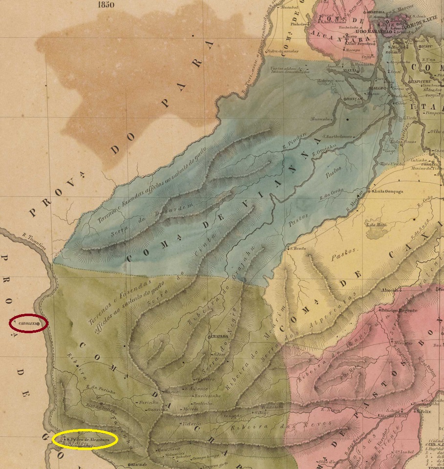
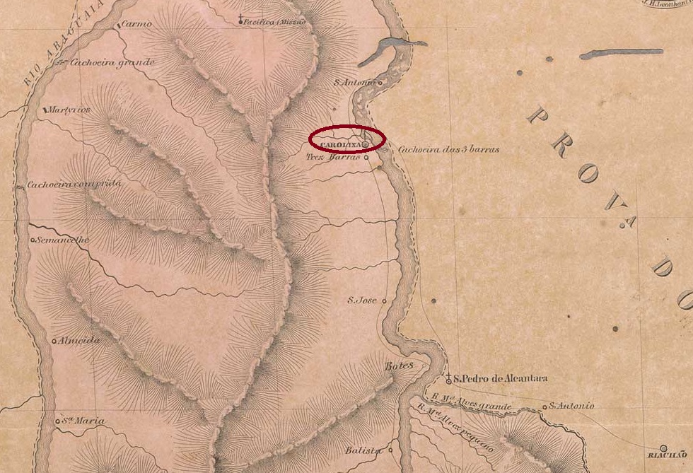
The original settlement was founded at the beginning of the 19th century under the name S. Pedro de Alcantara, located on the west bank of the Tocantins and thus still in the territory of the Capitania (later: province) of Goiás. Due to economic and climatic problems, the entire locality was moved further south to the east bank of the Tocantins around 1830, and then called S. Pedro de Alcantara. It was now located in the imperial province of Maranhão, 840 kilometres southwest of the capital São Luís. As the inhabitants continued to define themselves as Goiás citizens, they tried for decades to re-declare the new Vila as Goiás territory, until an imperial decree of August 1854 ended the dispute in Maranhão’s favour. Carolina has been a town since July 1859.
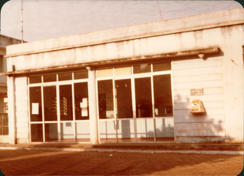
Carolina post ofice, ca. 1975 (Photo: IBGE)
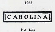
Three dates have been found for the foundation of the local post office. The first was in March 1829, as Nova Monteiro writes in Administrações e Agencias Postaes do Brasil Imperio (Brasil Filatelico/RJ, 1934-5; reprint SPP 1994-1999). The only known imperial postmark of Carolina dates from this Goiás period. CGO-0032a, which appears on Bull’s Eyes issues from 1843 and was assigned No. 1266 by Paulo Ayres (Catálogo de Carimbos Brasil-Império, S. Paulo, 1937, 1942):
CGO-0032a (P.A. 1266) 1843ff
The following dates are both from the Maranhão period. The directory of imperial post offices (Tabella das Agencias do Correio do Imperio, Rio de Janeiro, 1885) mentions the year 1855, while the postal report (Relatorio Postal) of 1886 mentions the Carolina post office from February 1871. No imperial postmarks from Carolina are known from this period.
Villiers de l’Ile Adam: Carta (…) da Provincia de Goyaz, 1849
Andere Namen: S. Pedro de Alcantara
Die ursprüngliche Siedlung entstand zu Beginn des 19. Jahrhunderts unter dem Namen S. Pedro de Alcantara. Pedro de Alcantara und lag am Westufer des Tocantins und damit noch im Gebiet der Capitania (später: Provinz) Goiás. Aufgrund wirtschaftlicher und klimatischer Probleme wurde der gesamte Ort um 1830 weiter südlich an das Ostufer des Tocantins verlegt und hieß dann S. Padro de Alcantara. Sie lag nun in der kaiserlichen Provinz Maranhão, 840 km südwestlich der Hauptstadt São Luís. Da sich die Einwohner weiterhin als Goiás-Bürger definierten, versuchten sie jahrzehntelang, die neue Vila zum Goiás-Territorium umzudeklarieren, bis ein kaiserliches Dekret vom August 1854 den Streit zugunsten Maranhãos beendete. Seit Juli 1859 ist Carolina eine Stadt.
Postamt Carolina (MA), ca. 1975 (Foto: IBGE)
Für die Gründung des örtlichen Postamtes wurden drei Daten gefunden. Die erste im März 1829, wie Nova Monteiro in Administrações e Agencias Postaes do Brasil Imperio (Brasil Filatelico/RJ, 1934-5; Nachdruck SPP 1994-1999) schreibt. Aus dieser Goiás-Zeit stammt der bisher einzige bekannte Poststempel Carolinas aus der Kaiserzeit, CGO-0032a, der auf Ausgaben von 1843 erscheint und von Paulo Ayres (Catálogo de Carimbos Brasil-Império, S. Paulo, 1937, 1942) mit der Nr. 1266 versehen wurde:
CGO-0032a (P.A. 1266) 1843ff
Die folgenden Daten stammen beide aus der Maranhão-Zeit. Im Verzeichnis der kaiserlichen Postämter (Tabella das Agencias do Correio do Imperio, Rio de Janeiro, 1885) findet sich das Jahr 1855, während im Postbericht (Relatorio Postal) von 1886 die Carolina-Postanstalt ab Februar 1871 erwähnt wird. Aus dieser Zeit sind keine kaiserlichen Poststempel von Carolina bekannt.
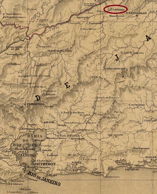
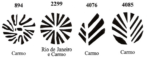
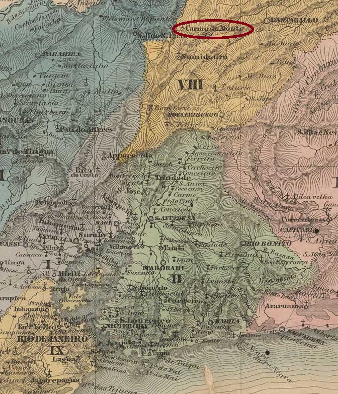
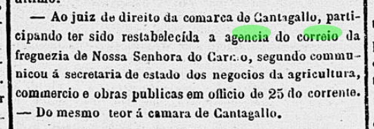
Other names: N. Sra. do Monte do Carmo, Carmo de Cantagallo
Curato de N. Sra. do Monte do Carmo was founded in January 1843 within the Vila de Cantagalo and was located on the east bank of the Paquequer, 200 kilometres north of the capital Rio de Janeiro. It became a freguesia in April 1846, a vila in October 1881 and a town in December 1889.
As R. Koester (Carimbologia IX) and Paulo Novaes (agenciaspostais.com.br) write, there had been a post office there since 1853. However, it was closed sometime after 1858, as the Rio press reported its reopening in July 1861:
Correio Mercantil, 18/08/1861
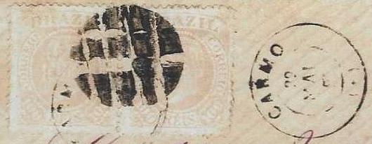
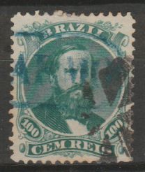
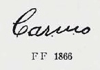
The first postmark is probably CRJ-0310a, which also exists in blue and red from 1853 to at least 1866 and was registered by Paulo Ayres in Catálogo de Carimbos Brasil-Império (S. Paulo, 1937, 1942) under no. 1265:
CRJ-0310a (P. A. 1265)
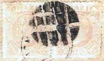
This postmark broke at some point, so it was cancelled by hand for a long time before the successor postmark was delivered:
(P.A. p.146) 1864-1878
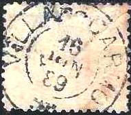
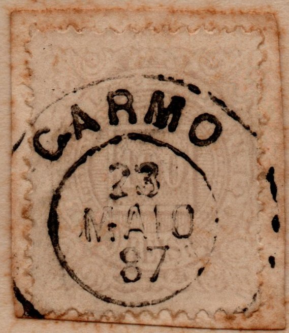
Then the time had come for CRJ-0310b (José A. Junges Collection), which was seen with dates from 1877-1888:
CRJ-0310b (JJ)
Its successor, the French type cancel CRJ-0310c (fig. Paulo R. Risi) was not in use for long:
CRJ-0310c (PRR) 1883ff
Then came CRJ-0310d (fig. agenciaspostais.com.br), which was found with dates from the end of the Empire:
CRJ-0310d (PN) 1889-1890
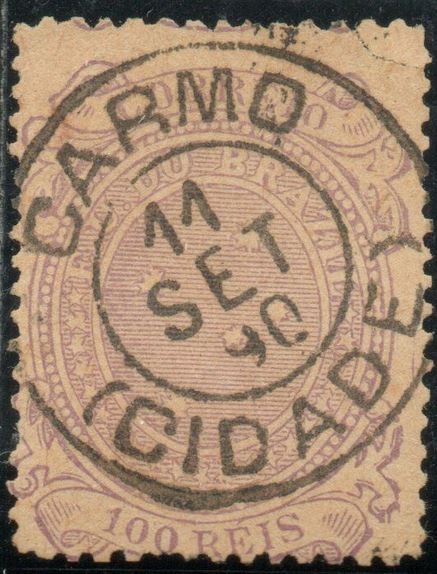
The first republican postmark CRJ-0310e (image from the Internet) proudly displays the designation CIDADE (city):
CRJ-0310e (EB) 1890-1898
Four mute cancellations from Carmo were registered by James Dingler and Klerman W. Lopes in Mute Cancellations of the Brazil Empire / Carimbos Mudos do Brasil Império (Brazil Philatelic Association, Rio de Janeiro, 2000):
Two other mute cancellations were found in the Empire:
1866ff (from the internet)1883ff (illustration by Paulo R. Risi)Villiers de l’Ile Adam: Carta (…) da Provincia do Rio de Janeiro, 1850
Andere Namen: N. Sra. do Monte do Carmo, Carmo de Cantagallo
Curato de N. Sra. do Monte do Carmo wurde im Januar 1843 als Vila de Cantagalo gegründet und liegt am Ostufer des Paquequer, 200 km nördlich der Hauptstadt Rio de Janeiro. Im April 1846 wurde sie zur Freguesia, im Oktober 1881 zur Vila und im Dezember 1889 zur Stadt.
Wie R. Koester (Carimbologia IX) und Paulo Novaes (agenciaspostais.com.br) schreiben, gab es dort seit 1853 ein Postamt. Dieses wurde jedoch irgendwann nach 1858 geschlossen, denn die Presse von Rio berichtete von seiner Wiedereröffnung im Juli 1861:
Correio Mercantil, 18.08.1861
Der erste Stempel ist wahrscheinlich CRJ-0310a, den es auch in blau und rot von 1853 bis mindestens 1866 gab und der von Paulo Ayres im Catálogo de Carimbos Brasil-Império (S. Paulo, 1937, 1942) unter der Nr. 1265 registriert wurde:
CRJ-0310a (P. A. 1265)
Dieser Stempel ging irgendwann kaputt, so dass lange Zeit per Hand entwertet wurde, bevor der Nachfolgestempel geliefert wurde:
(P.A. S.146) 1864-1878
Dann war es soweit, es kam CRJ-0310b (Samml. José A. Junges), der mit Daten von 1877-1888 gesehen wurde:
CRJ-0310b (JJ)
Sein Nachfolger, der „französische“ Stempel CRJ-0310c (Abb. Paulo R. Risi) war nicht lange in Gebrauch:
CRJ-0310c (PRR) 1883ff
Danach kam CRJ-0310d (Abb. agenciaspostais.com.br), der mit Daten vom Ende des Kaiserreichs gefunden wurde:
CRJ-0310d (PN) 1889-1890
Der erste republikanische Poststempel CRJ-0310e (Abb. aus dem Internet) zeigt stolz die Bezeichnung CIDADE (Stadt):
CRJ-0310e (EB) 1890-1898
Vier stumme Abstempelungen aus Carmo wurden von James Dingler und Klerman W. Lopes in Mute Cancellations of the Brazil Empire / Carimbos Mudos do Brasil Império (Brazil Philatelic Association, Rio de Janeiro, 2000) registriert:
Other names: Trairuçu, Monte do Carmo (1920-1938, 1953)
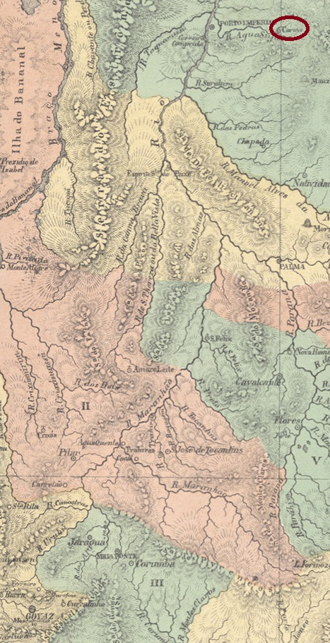
Arraial de N. Sra. do Monte do Carmo was founded around 1741, belonged to the Vila de Porto Real and was situated on the north bank of the Agua Suja, 750 km north of the former provincial capital Goyaz (today Goiás Velho). Around 1835 it became a freguesia of the Vila de Porto Imperial and in February 1895 a district of the Município de Porto Nacional. In 1920 it was renamed Monte do Carmo. The place name then changed three times: in October 1938 to Carmo, in December 1943 to Trairuçu, and in July 1953 back to Monte do Carmo, which became an independent município a good 10 years later.
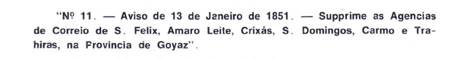
The creation date of the local post office has not yet been determined, but it was closed in January 1851, as Áureo G. Santos writes in Agências de Correio Criadas e Suprimidas 1851, 1855, 1856 e 1857 (Brasil Filatélico 181, Rio de Janeiro, 1977):
SANTOS, Aureo G. (op. cit.)
So far, no imperial postmark has been seen from Carmo in the province of Goiás, it must be very rare.
Villiers de l’Ile Adam: Carta (…) da Provincia de Goyaz, 1849
Andere Namen: Trairuçu, Monte do Carmo (1920-1938, 1953)
Arraial de N. Sra. do Monte do Carmo wurde um 1741 gegründet, gehörte zur Vila de Porto Real und lag am Nordufer des Agua Suja, 750 km nördlich der ehemaligen Provinzhauptstadt Goyaz (heute Goiás Velho). Um 1835 wurde es eine Freguesia der Vila de Porto Imperial und im Februar 1895 ein Distrikt des Município de Porto Nacional. 1920 erfolgte die Umbenennung in Monte do Carmo. Danach änderte sich der Ortsname dreimal: im Oktober 1938 in Carmo, im Dezember 1943 in Trairuçu und im Juli 1953 wieder in Monte do Carmo, das gut 10 Jahre später ein eigenständiges Município wurde.
Das Gründungsdatum des örtlichen Postamtes konnte bisher nicht ermittelt werden, nur dass es im Januar 1851 geschlossen wurde, wie Áureo G. Santos in Agências de Correio Criadas e Suprimidas 1851, 1855, 1856 e 1857 (Brasil Filatélico 181, Rio de Janeiro, 1977) schreibt:
SANTOS, Aureo G. (op. cit.)
Bisher wurde kein kaiserlicher Poststempel aus Carmo in der Provinz Goiás gesehen, er muss sehr selten sein.
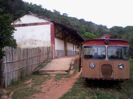
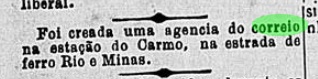
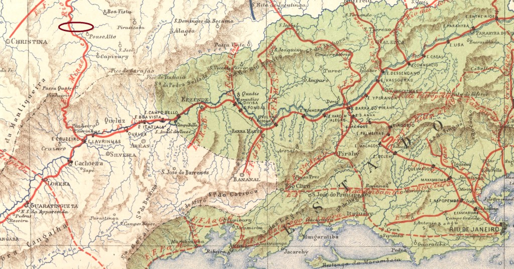
Carmo station was opened in June 1884 by the railway company E.F. Minas e Rio (Cruzeiro-Jureia line) and was in the Freguesia de Carmo do Rio Verde near Vila de Christina, 350 km south-west of the provincial capital Ouro Preto. The line changed hands several times: to Rede Sul-Mineira in 1910, Rede Mineira de Viação in 1931, V.F. Centro-Oeste in 1965 and Rede Ferroviária Federal S.A. (estacoesferroviarias.com.br) from 1975 until its closure in 1996. In 2014, the tracks were still in place and the station building served as a residential building.
In 2014 (Photo Bruno C. Sanches, on estacoesferroviarias.com.br)
The area around the railway station became part of the Município Silvestre Ferraz in September 1901 and has belonged to the Município Carmo de Minas since December 1953.
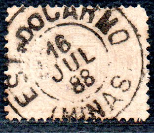
Paula Sobrinho in História Postal de Minas Gerais (Belo Horizonte, 1997) and R. Koester (Carimbologia IX) write that there was a post office in the railway station from May 1885. This is confirmed by the press in Rio:
Gazeta da Tarde/RJ, 26/05/1885
Koester also describes the imperial postmark CMG-0620a as a double circle, dated 1888 in the centre. Here its illustration, provided by Luiz C. Fritzen:
CMG-0620a (LCF) 1888Estrada de Ferro Central do Brasil, 1890
Textaktualisierung vom 24. November 2023
Andere Namen: Americo Lobo
Der Bahnhof Carmo wurde im Juni 1884 von der Eisenbahngesellschaft E.F. Minas e Rio (Linie Cruzeiro-Jureia) eröffnet und lag in der Freguesia de Carmo do Rio Verde bei Vila de Christina, 350 km südwestlich der Provinzhauptstadt Ouro Preto. Die Strecke wechselte mehrmals den Besitzer: 1910 an Rede Sul-Mineira, 1931 an Rede Mineira de Viação, 1965 an V.F. Centro-Oeste und von 1975 bis zur Stilllegung 1996 gehörte die Strecke der Rede Ferroviária Federal S.A. (estacoesferroviarias.com.br). 2014 waren die Gleise noch vorhanden, das Bahnhofsgebäude diente als Wohnhaus.
2014 (Foto Bruno C. Sanches, auf estacoesferroviarias.com.br)
Das Gebiet um den Bahnhof kam im September 1901 zum Município Silvestre Ferraz und gehört seit Dezember 1953 zum Município Carmo de Minas.
Paula Sobrinho in História Postal de Minas Gerais (Belo Horizonte, 1997) und R. Koester (Carimbologia IX) schreiben, dass es ab Mai 1885 ein Postamt im Bahnhof gab. Dies wird von der Presse in Rio bestätigt:
Gazeta da Tarde/RJ, 26.05.1885
Koester beschreibt auch den kaiserlichen Poststempel CMG-0620a als Doppelkreis, datiert 1888 in der Mitte. Hier die Abbildung, durch Luiz C. Fritzen vermittelt:
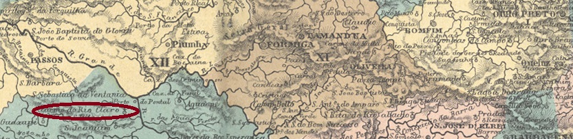
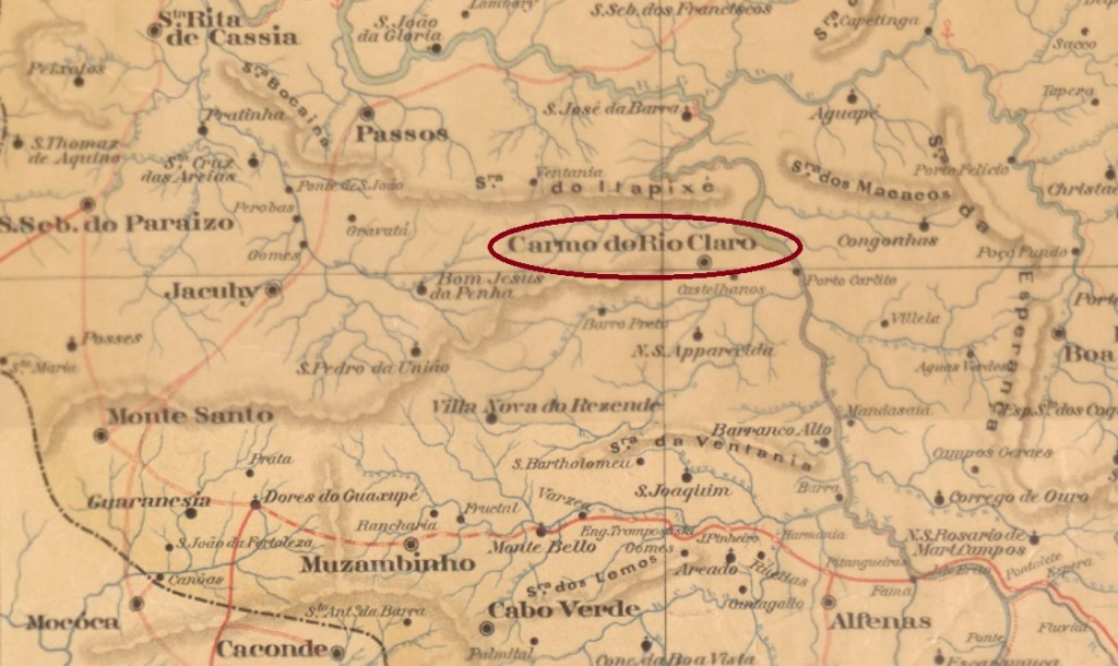
The Freguesia de N. Sra. do Carmo do Monte do Rio Claro was founded in November 1810, belonged to the Vila de Jacuhy and was located on the west bank of the Rio Sapucaí, 430 kilometres west of the provincial capital Ouro Preto. In October 1848 it became part of the newly founded Vila de Passos, became a Vila itself in October 1875 and two years later a town.
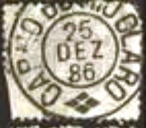
Paula Sobrinho (História Postal de Minas Gerais, Belo Horizonte, 1997) and R. Koester (Carimbologia IX) write that there has been a post office there since September 1873. The only imperial postmark to date is CMG-0685b (image from the Internet):
CMG-0685b (EB) 1886Estado de Minas Geraes, 1910
Die Freguesia de N. Sra. do Carmo do Monte do Rio Claro wurde im November 1810 gegründet, gehörte zur Vila de Jacuhy und lag am Westufer des Rio Sapucaí, 430 km westlich der Provinzhauptstadt Ouro Preto. Im Oktober 1848 kam es zu der neu gegründeten Vila de Passos, wurde im Oktober 1875 selbst zur Vila und zwei Jahre später zur Stadt.
Paula Sobrinho (História Postal de Minas Gerais, Belo Horizonte, 1997) und R. Koester (Carimbologia IX) schreiben, dass es dort seit September 1873 ein Postamt gab. Der bisher einzige kaiserliche Poststempel ist CMG-0685b (Abbildung aus dem Internet):
Villiers de l’Ile Adam: Carta (…) da Provincia de Minas Geraes, 1849
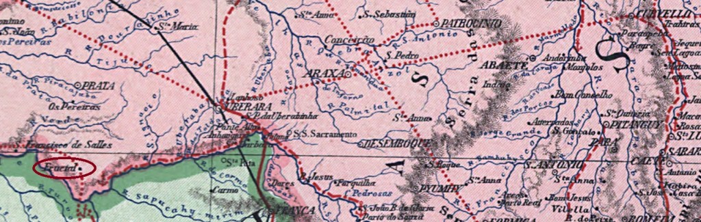
Text update on August 19. 2024 Other names: Carmo dos Morrinhos, Frutal (1923)
The Freguesia de N. Sra. do Carmo do Fructal was founded in September 1870, belonged to the Vila de Uberaba and was located on the east bank of the Frutal, 800 km west of the provincial capital Ouro Preto. In October 1885, it was elevated to a Vila and two years later to a town, which has borne the simplified name Frutal since September 1923.
As Paula Sobrinho writes in História Postal de Minas Gerais (Belo Horizonte, 1997), there has been a post office there since January 1882, although R. Koester (Carimbologia IX) gives a date exactly one month later. A recently discovered note from the Rio press confirms the date in January 1882:
Jornal do Commercio/RJ, 11/01/1882
Koester also mentions the double circle CMG-0670a as the first postmark (image: Luiz C. Fritzen), which presents dates from 1885 to 1889.
CMG-0670a (LCF) 1885-1889Carta da Republica dos Estados Unidos do Brazil, 1892
Textaktualisierung am 19.08.2024 Andere Namen: Carmo dos Morrinhos, Frutal (1923)
Die Freguesia de N. Sra. do Carmo do Fructal wurde im September 1870 gegründet, gehörte zur Vila de Uberaba und lag am Ostufer des Frutal, 800 km westlich der Provinzhauptstadt Ouro Preto. Im Oktober 1885 wurde es zur Vila und zwei Jahre später zur Stadt erhoben, die seit September 1923 den vereinfachten Namen Frutal trägt.
Wie Paula Sobrinho in História Postal de Minas Gerais (Belo Horizonte, 1997) schreibt, gibt es dort seit Januar 1882 ein Postamt, wobei R. Koester (CarimbologiaIX) ein genau einen Monat späteres Datum angibt. . Eine neuentdeckte Pressemeldung aus Rio bestätigt das Datum im Januar 1882:
Jornal do Commercio/RJ, 11.01.1882
Koester nennt auch als ersten Poststempel den Doppelkreis CMG-0670a (Abb. Luiz C. Fritzen) der bisher mit Daten von 1885 bis 1889 zu sehen war.
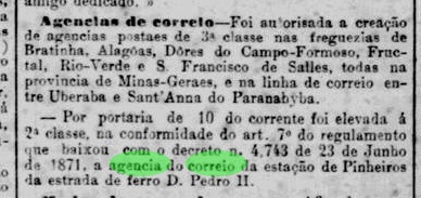
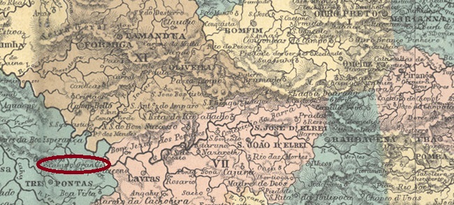
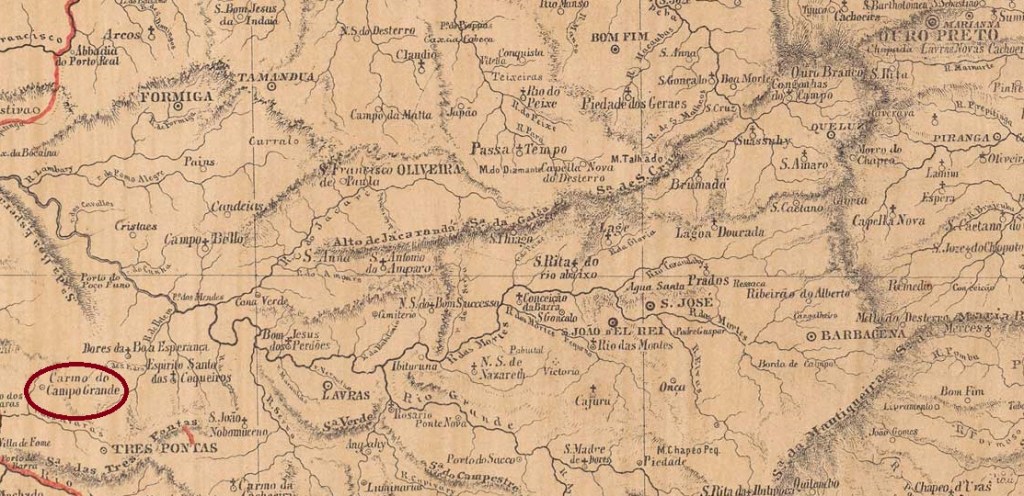
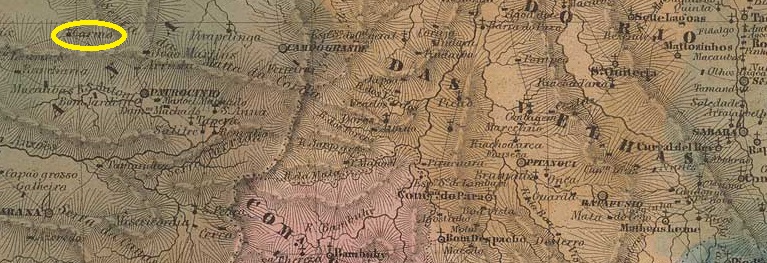
Other names: Divisa Vermelha, Campos Gerais (1901)
N. Sra. do Carmo do Campo Grande was a district of the Vila de Três Pontas from around 1841, located on the Córrego da Divisa, kilometres from the provincial capital of Ouro Preto. In September 1870 it became a freguesia and in September 1901 a vila with the name Campos Gerais. Campos Gerais has been a town since September 1915.
The establishment of a local post office was decided in October 1883, as reported by Paula Sobrinho in História Postal de Minas Gerais (Belo Horizonte, 1997) and R. Koester (Carimbologia IX). However, as the agency is not listed in the directory of imperial post offices (Tabella das Agencias do Correio do Império, Rio de Janeiro, 1885), it was probably not put into operation until later.
No imperial postmarks from Carmo do Campo Grande have yet been found.
Provincia de Minas Geraes, 1873
Andere Namen: Divisa Vermelha, Campos Gerais (1901)
N. Sra. do Carmo do Campo Grande war seit etwa 1841 ein Bezirk der Vila de Três Pontas, gelegen am Córrego da Divisa, km von der Provinzhauptstadt Ouro Preto entfernt. Im September 1870 wurde es zur Freguesia und im September 1901 zur Vila mit dem Namen Campos Gerais erhoben. Seit September 1915 ist Campos Gerais eine Stadt.
Die Einrichtung eines örtlichen Postamtes wurde im Oktober 1883 beschlossen, wie Paula Sobrinho in História Postal de Minas Gerais (Belo Horizonte, 1997) und R. Koester (Carimbologia IX) berichten. Da die Agentur jedoch nicht im Verzeichnis der kaiserlichen Postämter (Tabella das Agencias do Correio do Império, Rio de Janeiro, 1885) aufgeführt ist, wurde sie wahrscheinlich erst später in Betrieb genommen. Bisher wurden keine kaiserlichen Poststempel von Carmo do Campo Grande gefunden.
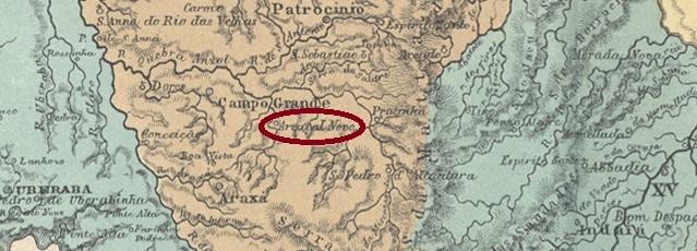
Other names: Arraial Novo de N. Sra. do Carmo da Ponte de Terra, Carmo do Paranahyba (1876)
The old Freguesia do Arraial Novo de N. Sra. do Carmo da Ponte de Terra was founded in March 1846, belonged to the Vila de Araxá and was located on the east bank of the Paranaíba, 440 km northwest of the provincial capital Ouro Preto. Elevated to Vila in September 1848, it was downgraded to Freguesia in October 1870, this time under the shorter place name N. Sra. do Carmo do Arraial Novo. It was re-elevated to vila in December 1873, renamed Vila de Carmo do Paranahyba in July 1876, and became a town in October 1887.
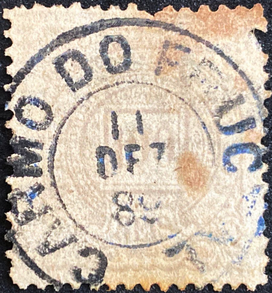
Again, Paula Sobrinho (História Postal de Minas Gerais, Belo Horizonte, 1997) and R. Koester (Carimbologia IX) agree that there was a post office since October 1873. The first postmark CMG-0660a also comes from the latter:
CMG-0660a (RK) 1877-1883
It was followed by the double circle with ornament below CMG-0660b, which was mentioned without illustration by R. Koester (op.cit.), one copy, dated 1886.
Later postmarks bear the place name Carmo do Paranahyba. All copies found so far have republican dates.
Viliers de l’Ile Adam: Carta (…) da Provincia de Minas Geraes, 1849
Andere Namen: Arraial Novo de N. Sra. do Carmo da Ponte de Terra, Carmo do Paranahyba (1876)
Die alte Freguesia do Arraial Novo de N. Sra. do Carmo da Ponte de Terra wurde im März 1846 gegründet, gehörte zur Vila de Araxá und lag am Ostufer des Paranaíba, 440 km nordwestlich der Provinzhauptstadt Ouro Preto. Im September 1848 zur Vila erhoben, wurde sie im Oktober 1870 zur Freguesia herabgestuft, diesmal unter dem kürzeren Ortsnamen N. Sra. do Carmo do Arraial Novo. Die Wiedererhebung zur Vila erfolgte im Dezember 1873, die Umbenennung in Vila de Carmo do Paranahyba im Juli 1876, und seit Oktober 1887 ist der Ort eine Stadt.
Auch hier sind sich Paula Sobrinho (História Postal de Minas Gerais, Belo Horizonte, 1997) und R. Koester (Carimbologia IX) einig, dass es seit Oktober 1873 ein Postamt gab. Von letzterem stammt auch der erste Poststempel CMG-0660a:
CMG-0660a (RK) 1877-1883
Ihm folgte der Doppelkreis mit Ornament unten CMG-0660b, dessen Exemplar aus 1886 von R. Koester (op.cit.) ohne Abbildung erwähnt wurde.
Spätere Poststempel tragen die Ortsbezeichnung Carmo do Paranahyba. Alle bisher gesehenen Exemplare haben Daten aus der Republik.