Categories
Carimbologia C-D

Capella Nova das Dores, Minas Gerais (CMG-0545)

Atlas do Imperio do Brasil, 1868

Other names: Capela Nova (1938)

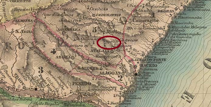
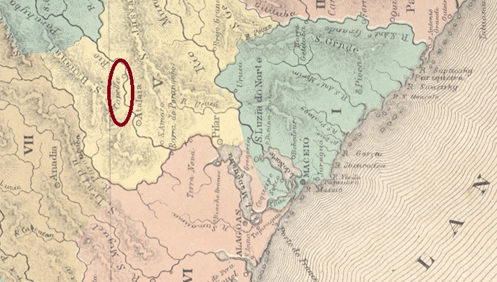
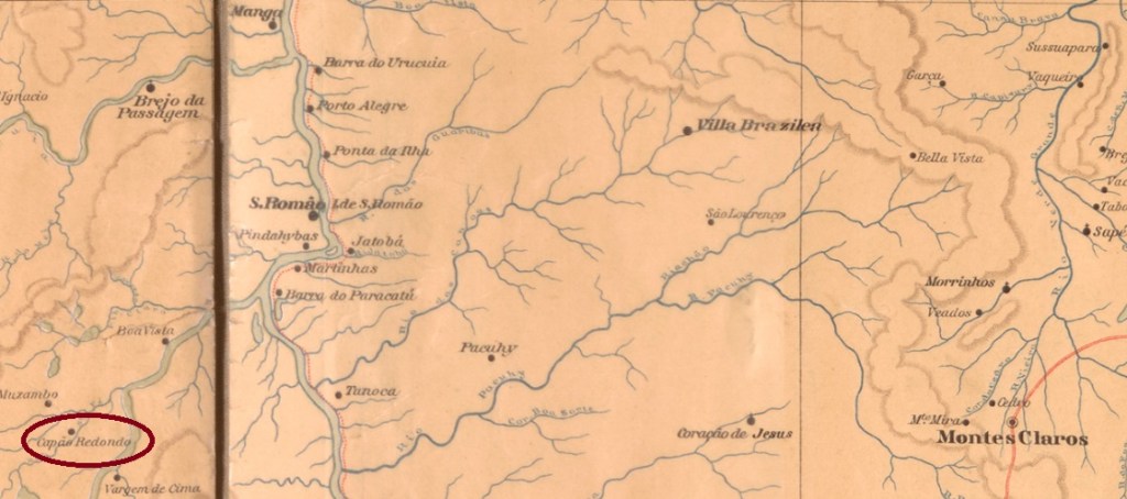
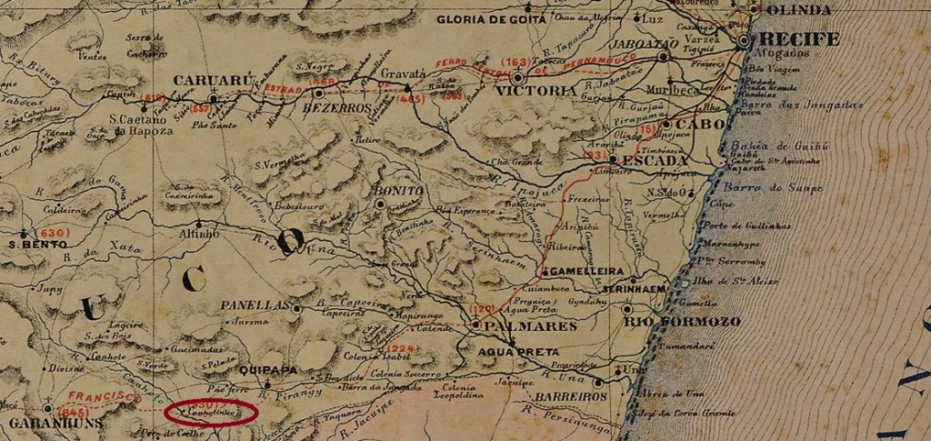
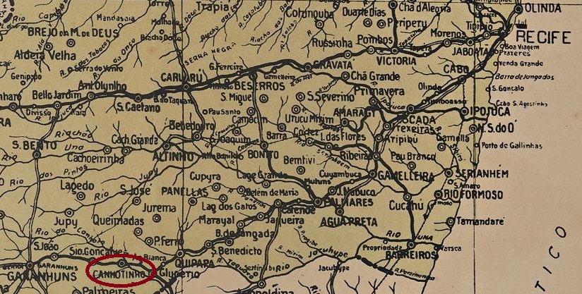
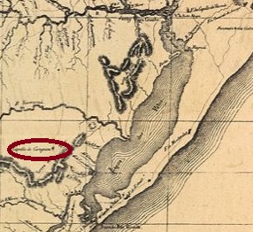
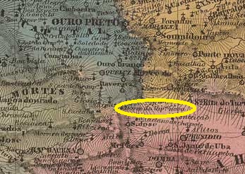
The Freguesia de N. Sra. das Dores da Capella Nova was founded in May 1856 and belonged to the Vila de Queluz, 120 km south of the provincial capital Ouro Preto. In September 1923, it was incorporated as a district into the newly created Município de Carandaí. After the simplification of the place name to Capela Nova in December 1938, the elevation to an independent Município followed five years later.

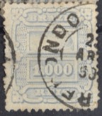
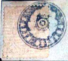
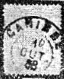
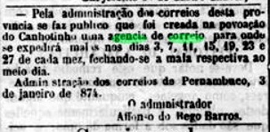
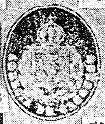
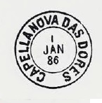
Both Paula Sobrinho (História Postal de Minas Gerais, Belo Horizonte, 1997) and Reinhold Koester (Carimbologia IX) agree that there had been a post office there since December 1877, even though it is not mentioned in the Imperial Postal Guide (Guia Postal do Imperio, Rio de Janeiro, 1880). In any case, the only imperial postmark so far is CMG-0545a, which also occurs in blue between 1885 and 1893 and has already been shown by P. Ayres in Catálogo de Carimbos Brasil-Império (S. Paulo, 1937, 1942):

CMG-0545a (P.A. p.120)

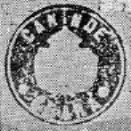
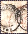
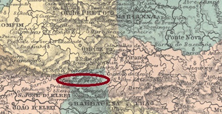
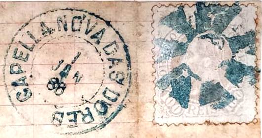
A mute cancellation from 1886 is also known from there (Collec. Fuad Ferreira Fo.):

1886 (FF)
Villiers de l’Ile Adam: Carta (…) da Provincia de Minas Geraes, 1849

Andere Namen: Capela Nova (1938)

Die Freguesia de N. Sra. das Dores da Capella Nova wurde im Mai 1856 gegründet und gehörte zur Vila de Queluz, 120 km südlich der Provinzhauptstadt Ouro Preto. Im September 1923 wurde es als Bezirk in das neu gegründete Município de Carandaí eingegliedert. Nach der Vereinfachung des Ortsnamens zu Capela Nova im Dezember 1938 folgte fünf Jahre später die Erhebung zum eigenständigen Município.

Sowohl Paula Sobrinho (História Postal de Minas Gerais, Belo Horizonte, 1997) als auch Reinhold Koester (Carimbologia IX) sind sich einig, dass es dort seit Dezember 1877 ein Postamt gab, auch wenn es im Kaiserlichen Postführer (Guia Postal do Imperio, Rio de Janeiro, 1880) nicht erwähnt wird. Jedenfalls ist der bisher einzige kaiserliche Poststempel CMG-0545a, der zwischen 1885 und 1893 auch in blau vorkommt und bereits von P. Ayres in Catálogo de Carimbos Brasil-Império (S. Paulo, 1937, 1942) gezeigt wurde:

CMG-0545a (P.A. S. 120)

Von dort ist auch eine stumme Entwertung von 1886 bekannt (Samml. Fuad Ferreira Fo.):

1886 (FF)
Categories
Carimbologia C-D

Capella, Alagoas (CAL-0050)

Villiers de l’Ile Adam: Carta (…) das Provincias de Pernambuco, Alagoas e Sergipe, 1848

Other names: Parahyba, Euclides Malta, Conceição da Paraíba.

The old Freguesia de N. Sra. da Conceição da Capella belonged to the Vila de Atalaia and was situated on the west bank of the Paraíba, about 60 km northwest of the later provincial capital Maceió. In October 1890, the village was elevated to the status of a vila under the name Parahyba, but in June 1904 it was renamed Euclides Malta. Further name changes followed: in June 1919 to Parahyba, in May 1929 to Capela, in December 1943 to Conceição da Paraíba and finally in September 1949 again to Capela.

The local post office was founded in August 1874, as Aldo Cardoso writes in Contribuição para a História dos Correios de Alagoas (Maceió, 1969). So far, no imperial postmark could be assigned with certainty to this place.

Atlas do Imperio do Brasil, 1868

Andere Namen: Parahyba, Euclides Malta, Conceição da Paraíba

Die alte Freguesia de N. Sra. da Conceição da Capella gehörte zur Vila de Atalaia und lag am Westufer des Paraíba, ca. 60 km nordwestlich der späteren Provinzhauptstadt Maceió. Im Oktober 1890 wurde der Ort unter dem Namen Parahyba zur Vila erhoben, im Juni 1904 jedoch in Euclides Malta umbenannt. Weitere Namensänderungen folgten: im Juni 1919 in Parahyba, im Mai 1929 in Capela, im Dezember 1943 in Conceição da Paraíba und schließlich im September 1949 wieder in Capela.

Das örtliche Postamt wurde im August 1874 gegründet, wie Aldo Cardoso in Contribuição para a História dos Correios de Alagoas (Maceió, 1969) schreibt. Bisher konnte kein kaiserlicher Poststempel mit Sicherheit diesem Ort zugeordnet werden.

Categories
Carimbologia C-D

Capão Redondo, Minas Gerais (CMG-0540)

Atlas do Imperio do Brasil, 1868

Other names: Santa Fé de Minas (1962)

This is a rare case of a settlement whose Catholic patronage has been changed several times. The settlement was originally called Santa Fé, belonged to the Vila of S. Romão and was located on the west bank of the river of the same name (a tributary of the Paracatu, which in turn flows into the São Francisco), 570 km north of the provincial capital Ouro Preto. In January 1875, it was elevated to a freguesia under the name Sant’Anna do Capão Redondo, which was incorporated into the newly created Município São Francisco in November 1877. In October 1881, the freguesia was renamed N. Sra. da Conceição do Capão Redondo, and under this name it was incorporated as a district into the reestablished Município S. Romão in September 1923. This district was given the (original) name of Santa Fé again in December 1962 and became the independent Município Santa Fé de Minas barely three months later.

The local post office was founded in August 1881, according to consistent sources. Two imperial postmarks were found. CMG-0540a (fig. Corinphila Auctions) is probably the oldest:

CMG-0540a (CO) 1890

The philatelist Fuad Ferreira Fo. also has the seal cancel CMG-0540b in his collection:

CMG-0540b (FF) 1883ff
Estado de Minas Geraes, 1910

Andere Namen: Santa Fé de Minas (1962)

Hier handelt es sich um den seltenen Fall einer Ortschaft, deren katholischen Patrozinium mehrmals geändert wurde. Die Siedlung hieß ursprünglich Santa Fé, gehörte zur Vila von S. Romão und lag am Westufer des gleichnamigen Flusses (ein Nebenfluss des Paracatu, der wiederum in den São Francisco mündet), 570 km nördlich der Provinzhauptstadt Ouro Preto. Im Januar 1875 wurde sie zur Freguesia unter dem Namen Sant’Anna do Capão Redondo erhoben, die im November 1877 in das neu gegründete Município São Francisco eingegliedert wurde. Im Oktober 1881 wurde die Freguesia in N. Sra. da Conceição do Capão Redondo umbenannt, und unter diesem Namen wurde sie im September 1923 als Distrikt in das neu gegründete Município S. Romão eingegliedert. Dieser Distrikt erhielt im Dezember 1962 wieder den (ursprünglichen) Namen Santa Fé und wurde knapp drei Monate später zum eigenständigen Município Santa Fé de Minas.

Das örtliche Postamt wurde nach übereinstimmenden Quellen im August 1881 gegründet. Es wurden zwei kaiserliche Poststempel gefunden. CMG-0540a (Abb. Corinphila Auktionen) ist wahrscheinlich der älteste:

CMG-0540a (CO) 1789

Der Philatelist Fuad Ferreira Fo. hat auch den Siegelstempel CMG-0540b in seiner Sammlung:

CMG-0540b (FF) 1883ff
Categories
Carimbologia C-D

Cantagallo, Rio de Janeiro (CRJ-0295)

Villiers de l’Ile Adam: Carta (…) da Provincia do Rio de Janeiro, 1850

The Freguesia de S. Pedro de Cantagallo was founded in October 1806, belonged to the Vila de Sto. Antonio de Sá and was located 230 km northeast of the capital Rio de Janeiro. It became a vila in March 1814 and a town in October 1857.

As Nova Monteiro writes in Administrações e Agencias Postaes do Brasil Imperio (Brasil Filatelico/RJ, 1934-5; Reprint SPP 1994-1999), there was a post office there from January 1820. Pre-philatelic covers are very rare here, but one suspects that the first postmark is CRJ-0295a. The illustration in the RHM catalogue is not very accurate here, as it is actually a hexagon, as the illustration in the Henrique B. Ferreiras Catálogo ilustrado dos carimbos sobre os olhos-de-boi (4a. ed, Porto Alegre, 2017) shows:

CRJ-0295 (RHM P-RJ-07, recte HBF) ca. 1840ff

It was followed by the rare CRJ-0295b, presumably in service from 1857 (when Cantagallo became a town) and presented by Paulo Ayres in the Catálogo de Carimbos Brasil-Império, (S. Paulo, 1937, 1942) under no. 1566:

CRJ-0295b (P.A. 1566) 1857ff

CRJ-0295c is a remake of CRJ-0295a and is often confused with it, but here the corners have been replaced by curves. It is available in red, green and blue and can also be seen at Paulo Ayres (op. cit.), now under no. 1258:

CRJ-0295c (P.A. 1258) 1861ff-1866ff

The French type CRJ-0295d was used between 1867 and 1888 and is also shown at Ayres:

CRJ-0295d (P.A. p. 117, MPT 392) 1867-1888

In the late imperial period CRJ-0295e (Fig. Dieter Kerkhoff) was added:

CRJ-0295e (DK) 1888-1900

And R. Koester showed us in Carimbologia VIII the seal cancel CRJ-0295f (RK)

CRJ-0295f (RK)

Five mute cancellations from the imperial Cantagallo were registered by James Dingler and Klerman W. Lopes in Mute Cancellations of the Brazil Empire / Carimbos Mudos do Brasil Império (Brazil Philatelic Association, Rio de Janeiro, 2000):

BPA 548 – 839 – 3316 (P.A. 715, 1885ff) – 3566 – 3931
Atlas do Imperio do Brasil, 1868

Die Freguesia de S. Pedro de Cantagallo wurde im Oktober 1806 gegründet, gehörte zur Vila de Sto. Antonio de Sá und lag 230 km nordöstlich der Hauptstadt Rio de Janeiro. Im März 1814 wurde es zur Vila und im Oktober 1857 zur Stadt erhoben.

Wie Nova Monteiro in Administrações e Agencias Postaes do Brasil Imperio (Brasil Filatelico/RJ, 1934-5; Reprint SPP 1994-1999) schreibt, gab es dort ein Postamt ab Januar 1820. Vorphilatelistische Belege sind hier sehr selten, aber man vermutet, dass der erste Poststempel CRJ-0295a ist. Die Abbildung im RHM-Katalog ist hier nicht sehr genau, da es sich eigentlich um ein Sechseck handelt, wie die Abbildung im Henrique B. Ferreiras Catálogo ilustrado dos carimbos sobre os olhos-de-boi (4a. ed, Porto Alegre, 2017) zeigt:

CRJ-0295a (RHM P-RJ-07, recte HBF) ca. 1840ff

Ihm folgte der seltene CRJ-0295b, der vermutlich ab 1857 (als Cantagallo eine Stadt wurde) eingesetzt wurde und durch Paulo Ayres im Catálogo de Carimbos Brasil-Império (S. Paulo, 1937, 1942) mit Nr. 1566 bekannt ist:

CRJ-0295b (P.A. 1566) 1857ff

CRJ-0295c ist ein Remake von CRJ-0295a und wird oft mit diesem verwechselt, aber hier wurden die Ecken durch Rundungen ersetzt. Es gibt ihn in rot, grün und blau, er ist auch bei Paulo Ayres (op. cit.) zu sehen, diesmal unter Nr. 1258:

CRJ-0295c (P.A. 1258) 1861ff-1866ff

Der französische Typ CRJ-0295d wurde zwischen 1867 und 1888 verwendet und ist auch bei Ayres abgebildet:

CRJ-0295d (P.A. S. 117, MPT 392) 1867-1888

In der späten Kaiserzeit kam CRJ-0295e (Abb. Dieter Kerkhoff) hinzu:

CRJ-0295e (DK) 1888-1900

Und R. Koester zeigte uns in Carimbologia VIII den Siegelstempel CRJ-0295f (RK)

CRJ-0295 (RK)

Fünf stumme Entwertungen aus dem kaiserlichen Cantagallo wurden von James Dingler und Klerman W. Lopes in Mute Cancellations of the Brazil Empire / Carimbos Mudos do Brasil Império (Brazil Philatelic Association, Rio de Janeiro, 2000) registriert:

BPA 548-839-3316 (P.A. 715, 1885ff) -3566-3931
Categories
Carimbologia C-D

Canoa (train station/Bahnhof), Ceará (CCE-0085)

Carta da Republica dos Estados Unidos do Brazil, 1892

Other names: Aracoiaba (1890)

Canoa (also spelled Canoas) was a freguesia of the Vila de Baturité founded in August 1874 and located on the river of the same name, 95 km south of the provincial capital Fortaleza. In August 1890, it was elevated to the status of a vila under the name Aracoiaba. This name comes from the Tupi language and means “place where the birds sing”. Aracoiaba was downgraded to the district of Baturité in May 1931, but regained its status as a município in December 1933.

The railway station was inaugurated in March 1880 by the E.F. de Baturité company. The railway line passed to Rede de Viação Cearense in 1909 and belonged to Rede Ferroviária Federal S.A. (estacoesferroviarias.com.br) from 1975 until its closure in 1997. Today the tracks are still there, the station building is in ruins.

Around 1920 (Biblioteca Nacional, on estacoesferroviarias.com.br)
In 2021 (Photo: Geraldo Langovsky, on estacoesferroviarias.com.br)

As shown in the Directory of Imperial Post Offices (Tabella das Agencias do Correio do Imperio, Rio de Janeiro, 1885), there had been a post office in the station since 1880, with the stationmaster as its first employee:

Gazeta do Norte, 17. 11.1880

R. Koester showed two imperial postmarks from Canoa in Carimbologia VIII:

CCE-0085a (RK) 1889
CCE-0085b (RK)
Sociedade Geologica e Mineralogica, 1910

Andere Namen: Aracoiaba (1890)

Canoa (auch Canoas geschrieben) war eine im August 1874 gegründete Freguesia der Vila de Baturité und lag am gleichnamigen Fluss, 95 km südlich der Provinzhauptstadt Fortaleza. Im August 1890 wurde sie unter dem Namen Aracoiaba zur Vila erhoben. Dieser Name stammt aus der Tupi-Sprache und bedeutet „Ort, an dem die Vögel singen“. Aracoiaba wurde im Mai 1931 zum Distrikt von Baturité herabgestuft, erhielt aber im Dezember 1933 den Status eines Município zurück.

Der Bahnhof wurde im März 1880 von der Gesellschaft E.F. de Baturité eingeweiht. Die Bahnlinie ging 1909 an die Rede de Viação Cearense über und gehörte von 1975 bis zu ihrer Schließung 1997 der Rede Ferroviária Federal S.A. (estacoesferroviarias.com.br). Heute sind die Gleise noch vorhanden, das Bahnhofsgebäude ist eine Ruine.

Um 1920 (Biblioteca Nacional, auf estacoesferroviarias.com.br)
2021 (Foto: Geraldo Langovsky, auf estacoesferroviarias.com.br)

Wie aus dem Verzeichnis der kaiserlichen Postämter (Tabella das Agencias do Correio do Imperio, Rio de Janeiro, 1885) hervorgeht, gab es im Bahnhof seit 1880 ein Postamt, dessen erster Angestellter der Bahnhofsvorsteher war:

Gazeta do Norte, 17.11.1880

R. Koester zeigte zwei kaiserliche Poststempel aus Canoa in Carimbologia VIII:

CCE-0085a (RK) 1889
CCE-0085b (RK)
Categories
Carimbologia C-D

Cannabrava, Bahia (CBA-0235)

Estado da Bahia, 1913

Other names: Cannabrava dos Caldeiras, Caldeiras (1938).

The Freguesia de N. Sra. do Rosário da Cannabrava was founded in May 1874, belonged to the Vila de Caetité and was located about 700 km west of the provincial capital Salvador da Bahia. This has remained the case to this day, apart from the fact that the place has been called the District of Caldeiras since November 1938.

The local post office was opened in August 1889, as reported by the Rio press:

Gazeta de Noticias/RJ, 05.08.1891

The oldest postmark so far is CBA-0235a (image from the internet), only one copy known, with a date of 1891:

CBA-0235a (EB) 1891
Carta da Republica dos Estados Unidos do Brazil, 1892

Andere Namen: Cannabrava dos Caldeiras, Caldeiras (1938)

Die Freguesia de N. Sra. do Rosário da Cannabrava wurde im Mai 1874 gegründet, gehörte zur Vila de Caetité und lag etwa 700 km westlich der Provinzhauptstadt Salvador da Bahia. Dies ist bis heute so geblieben, abgesehen davon, dass der Ort seit November 1938 Distrikt von Caldeiras heißt.

Das örtliche Postamt wurde im August 1889 eröffnet, wie die Presse von Rio berichtet:

Gazeta de Noticias/RJ, 05.08.1889

Der bisher älteste Poststempel ist CBA-0235a (Abbildung aus dem Internet); ein Exemplar bekannt, mit einem Datum von 1891:

CBA-0235a (EB) 1891
Categories
Carimbologia C-D

Canindé, Ceará (CCE-0080)

Villiers de l’Ile Adam: Carta (…) da Provincia do Ceará, 1849

The Freguesia de S. Francisco das Chagas do Canindé was founded in September 1818 on the west bank of the Canindé and belonged to the Vila de Fortaleza, of which it was 120 km to the southwest. It became a vila in July 1846 and a town in August 1914.

Two foundation dates have been found for the local post office. The first in July 1846, as R. Koester writes in Carimbologia VIII. Then in August 1859, as shown in Nova Monteiro’s Administrações e Agencias Postaes do Brasil Imperio (Brasil Filatelico/RJ, 1934-5; reprint SPP 1994-1999). If the second date is also correct, the agency must have closed shortly before, because it was listed in the Guia do Correio do Brasil (Rio de Janeiro, 1857). But as early as October 1849, the regional press reported regular postal traffic to Canindé:

O Cearense, 15.10.1849

Again, unfortunately, only later postmarks could be found, both at Koester (op. cit.):

CCE-0080b (RK) 1888
CCE-0080c (RK)
Carta da Capitania do Ceará, 1818

Die Freguesia de S. Francisco das Chagas do Canindé wurde im September 1818 am Westufer des Canindé gegründet und gehörte zur 120 km südwestlich gelegenen Vila de Fortaleza. Im Juli 1846 wurde es zur Vila und im August 1914 zur Stadt erhoben.

Für das örtliche Postamt wurden zwei Gründungsdaten gefunden. Das erste im Juli 1846, wie R. Koester in Carimbologia VIII schreibt. Dann im August 1859, wie aus Nova Monteiros Administrações e Agencias Postaes do Brasil Imperio (Brasil Filatelico/RJ, 1934-5; Nachdruck SPP 1994-1999) hervorgeht. Wenn auch das zweite Datum stimmt, muss die Agentur kurz zuvor geschlossen worden sein, denn sie war im Guia do Correio do Brasil (Rio de Janeiro, 1857) verzeichnet. Aber bereits im Oktober 1849 berichtete die regionale Presse über einen regelmäßigen Postverkehr nach Canindé:

O Cearense, 15.10.1849

Auch hier konnten leider nur spätere Poststempel gefunden werden, beide bei Koester (op. cit.):

CCE-0080b (RK) 1888
CCE-0080c (RK)
Categories
Carimbologia C-D

Canhotinho, Pernambuco (CPE-0170)

Carta Corographica da Provincia de Pernambuco, 1880

According to a beautiful local legend, two brothers once lived as farmers on the northern bank of a river. The older brother lost his right hand and had to become left-handed (Canhoto). His younger brother was called Canhotinho, and this nickname became the place name as the settlement continued to grow.

Since it is hard to believe that the river was previously nameless, the place name Canhotinho could simply means headwaters (or tributaries) of the Canhoto River. Anyway, the Freguesia de S. Sebastião do Canhotinho was founded in July 1882 on the north bank of the Canhoto near Vila de S. Bento, close to the provincial border with Alagoas, 210 km southwest of the capital Recife. Canhotinho was elevated to vila status in October 1890 and to town status in May 1903. In November 1888, a station of the E.F. Recife ao São Francisco railway company was inaugurated.

As can be seen from the Directory of Imperial Post Offices (Tabella das Agencias do Correio do Imperio, Rio de Janeiro, 1885), it was decided to establish the local post office in 1873. However, it did not start operating until the following January:

Diario de Pernambuco, 06.01.1874

It is quite possible that this post office was moved to the station after the arrival of the railway in 1888. The only postmark from the imperial period so far is the French type CPE-0170a (Fig. Jorge L. Pedreira):

CPR-0170a (JP) 1885ff-1888ff
Arthur D. Ribeiro: Estado de Pernambuco, 1924

Nach einer schönen lokalen Legende lebten einst zwei Brüder als Bauern am nördlichen Ufer eines Flusses. Der ältere Bruder verlor seine rechte Hand und musste zum Linkshänder (Canhoto) werden. Sein jüngerer Bruder wurde Canhotinho genannt, und dieser Spitzname wurde zum Ortsnamen, als die Siedlung weiter wuchs.

Da es schwer zu glauben ist, dass der Fluss vorher namenlos war, könnte die Ortsbezeichnung Canhotinho einfach Oberlauf (oder Zufluss) des Canhoto. Wie dem auch sei, wurde die Freguesia de S. Sebastião do Canhotinho im Juli 1882 am Nordufer des Canhoto in der Nähe von Vila de S. Bento, nahe der Provinzgrenze zu Alagoas, 210 km südwestlich der Hauptstadt Recife, gegründet. Canhotinho wurde im Oktober 1890 zur Vila und im Mai 1903 zur Stadt erhoben. Im November 1888 wurde ein Bahnhof der Eisenbahngesellschaft E.F. Recife ao São Francisco eingeweiht.

Wie aus dem Verzeichnis der kaiserlichen Postämter (Tabella das Agencias do Correio do Imperio, Rio de Janeiro, 1885) hervorgeht, wurde 1873 die Gründung des örtlichen Postamtes beschlossen. Diese nahm jedoch erst im darauffolgenden Januar ihren Betrieb auf:

Diario de Pernambuco, 06.01.1874

Es ist gut möglich, dass dieses Postamt nach der Ankunft der Eisenbahn 1888 an den Bahnhof verlegt wurde. Der bisher einzige Poststempel aus der Kaiserzeit ist der französische Typ CPE-0170a (Abb. Jorge L. Pedreira):

CPE-0170a (JP) 1885ff-1888ff
Categories
Carimbologia C-D

Canguaretama, Rio Grande do Norte (CRN-0045)

Atlas do Imperio do Brasil, 1868

Other names: Uruá, Vila Flor

The history of this place – as well as that of the local post office – is very sketchy. The former settlement of Uruá belonged to Vila Flor and was situated on the north bank of the river Cunhaú, now Curimataú, 80 km south of the provincial capital Natal. Vila Flor lost its status as a villa to Uruá, which was now called Canguaretama, in July 1858 due to an epidemic or some other natural event. Canguaretama has been a town since April 1885. The indigenous name means land of many Canguás. Canguá is the name of Bairdiella ronchus, a fish from the Scienidae family.

Bairdiella ronchus (Cuv. 1810); Photo U. Krumme

Since when exactly there was an imperial post office here could not be clarified so far. Vila Flor still had a post office around 1856, but it was moved to the neighbouring village of Penha around 1860, where it was still in operation in 1872. However, a post office in Canguaretama is mentioned in the provincial president’s report in 1873:

Relatorio do Presidente da Provincia, June 1873

The post office must have closed by 1879, however, as it is not mentioned in the 1880 postal guide (Guia Postal do Império) or in the list of imperial post offices (Tabella das Agencias do Correio do Imperio, Rio de Janeiro, 1885). However, it can be assumed that it was reopened by the end of the 19th century at the latest. So far, no imperial postmarks from Canguaretama are known.

Sociedade Geológica e Mineralógica, 1910

Andere Namen: Uruá, Vila Flor

Die Geschichte dieses Ortes – wie auch die des örtlichen Postamtes – ist sehr lückenhaft. Die ehemalige Siedlung Uruá gehörte zu Vila Flor und lag am Nordufer des Flusses Cunhaú, heute Curimataú, 80 km südlich der Provinzhauptstadt Natal. Vila Flor verlor seinen Status als Villa im Juli 1858 durch eine Epidemie oder ein anderes Naturereignis an Uruá, das nun Canguaretama hieß. Seit April 1885 ist Canguaretama eine Stadt. Der indigene Name bedeutet viele Canguás. Canguá ist der volkstümliche Name von Bairdiella ronchus, einem Fisch aus der Familie Scienidae.

Bairdiella ronchus (Cuv. 1810); Foto: U. Krumme

Seit wann genau es hier ein kaiserliches Postamt gab, konnte bisher nicht geklärt werden. Vila Flor hatte noch um 1856 eine Postagentur, die aber um 1860 in den Nachbarort Penha verlegt wurde, wo sie 1872 noch in Betrieb war. Ein Postamt in Canguaretama wird jedoch 1873 im Bericht des Provinzpräsidenten erwähnt:

Relatorio do Presidente da Provincia, Juni 1873

Das Postamt muss jedoch bereits 1879 geschlossen worden sein, da es weder im Postführer (Guia Postal do Império) von 1880 noch im Verzeichnis der kaiserlichen Postämter (Tabella das Agencias do Correio do Imperio, Rio de Janeiro, 1885) erwähnt wird. Es ist dennoch davon auszugehen, dass es spätestens Ende des 19. Jahrhunderts wieder eröffnet wurde. Bisher sind keine kaiserlichen Poststempel aus Canguaretama bekannt.

Categories
Carimbologia C-D

Cangossu/Cangussu, Rio Grande do Sul (CRS-0085)

Villiers de l’Ile Adam: Carta (…) da Provincia de São Pedro do Sul, 1847

The Freguesia de N. Sra. da Conceição de Cangussu (formerly also Cangossu, today spelled Canguçu) was founded as early as January 1812 and was located on the east bank of the Arroio Saraiva River, 280 km southwest of the later provincial capital Porto Alegre. In January 1857, it was elevated to a villa as an independent municipality.

The local post office was established in June 1861, according to a government report

Boletim do Expediente do Governo, 1861

Three postmarks have been found so far for the imperial period, unfortunately not yet the oldest. The double circle CRS-0085b (Fig. Jorge L. Pedreira) has inner dates from 1877 to 1882:

CRS-0085b (JLP) 1877-1882

Its successor CRS-0085c (fig. from the internet) already shows a changed spelling:

CRS-0085c (EB) 1884-1892

Then R. Koester presented the seal cancel CRS-0085d in Carimbologia VIII:

CRS-0085d (RK)
Capitania de São Pedro, 1777

Die Freguesia de N. Sra. da Conceição de Cangussu (früher auch Cangossu, heute nur noch Canguçu geschrieben) wurde bereits im Januar 1812 gegründet und lag am Ostufer des Flusses Arroio Saraiva, 280 km südwestlich der späteren Provinzhauptstadt Porto Alegre. Im Januar 1857 wurde es zu einer villa als eigenständige Gemeinde erhoben.

Das örtliche Postamt wurde im Juni 1861 gegründet, wie aus einem Regierungsbericht hervorgeht:

Boletim do Expediente do Governo, 1861

Für die Kaiserzeit wurden bisher drei Poststempel gefunden, leider noch nicht der älteste. Der Doppelkreis CRS-0085b (Abb. Jorge L. Pedreira) hat innere Daten von 1877 bis 1882:

CRS-0085b (JLP) 1877-1882

Sein Nachfolger CRS-0085c (Abb. aus dem Internet) zeigt bereits eine geänderte Schreibweise:

CRS-0085c (EB) 1884-1892

Dann hat R. Koester noch den Siegelstempel CRS-0085d in Carimbologia VIII vorgestellt:

CRS-0085d (RK)