Carta Corographica da Provincia de Pernambuco, 1880
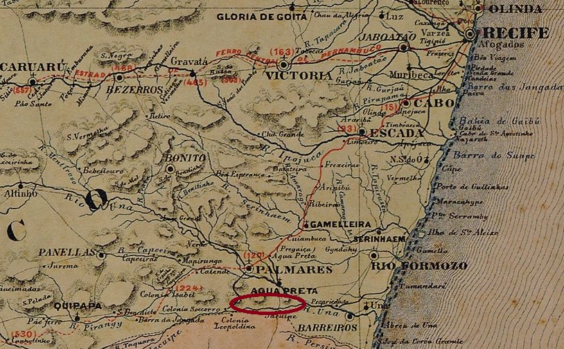
Campos Frios was a small settlement, belonging to the Vila de Agua Preta, on the north bank of the Jacuípe River, right on the provincial border with Alagoas, 150 km southwest of the provincial capital Recife. The place became a district at the beginning of the Republic but lost this status in April 1930 when it was incorporated into the district of Xexéu. Since October 1991, Campos Frios has been a district of the Município Xexéu.
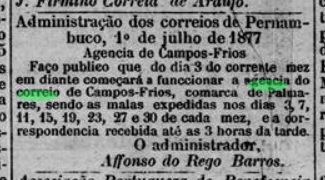
According to the Directory of Imperial Post Offices (Tabella das Agencias do Correio do Imperio, Rio de Janeiro, 1885), there had been a post office there since 1877, which began operating in July of that year:
Diaio de Pernambuco, 03.07.1877
No imperial postmarks are known from Campos Frios so far.
Google Maps
Campos Frios war eine kleine Siedlung der Vila de Agua Preta, die am Nordufer des Flusses Jacuípe, direkt an der Provinzgrenze zu Alagoas, 150 km südwestlich der Provinzhauptstadt Recife lag. Der Ort wurde zu Beginn der Republik zu einem Distrikt, verlor diesen Status jedoch im April 1930, als er dem Distrikt Xexéu angegliedert wurde. Seit Oktober 1991 ist Campos Frios eine Gemeinde des Município Xexéu.
Nach dem Verzeichnis der kaiserlichen Postämter (Tabella das Agencias do Correio do Imperio, Rio de Janeiro, 1885) gab es dort seit 1877 ein Postamt, das im Juli desselben Jahres seinen Betrieb aufnahm:
Diario de Pernambuco, 03.07.1877
Aus Campos Frios sind bisher keine kaiserlichen Poststempel bekannt.
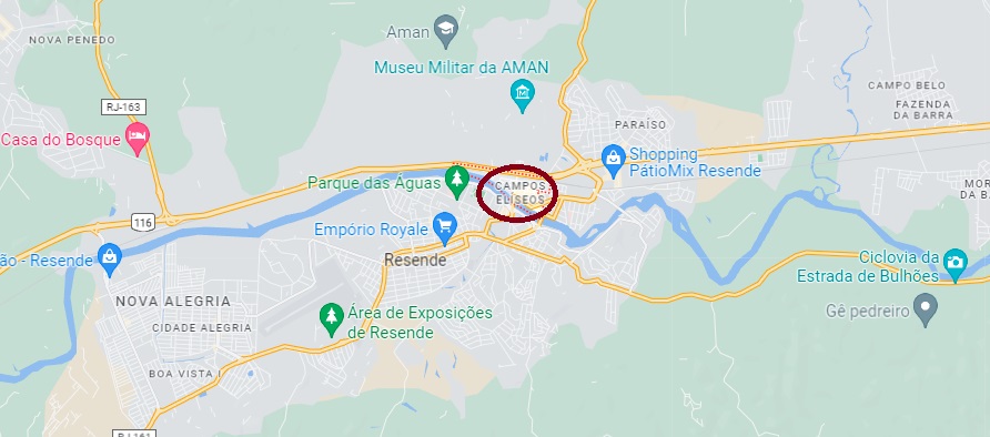
Campos Elyseos has been a district of Resende on the north bank of the Paraíba do Sul, 160 km northwest of the capital Rio de Janeiro, for over 150 years. Known for its proximity to the Agulhas Negras Military Academy, it is a prestigious place to live and is now well integrated into the cityscape.
A local post office existed since September 1882, as R. Koester writes in Carimbologia VIII. From him we also have the illustration of the first postmark CRJ-0290a:
CRJ-0290a (RK) 1884-1890ff
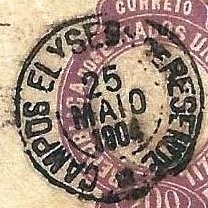
Its successor CRJ-0290b is probably already republican because it bears internal dates from 1895 to 1904. Here is the image from Paulo Novaes’s agenciaspostais.com.br:
CRJ-0290b (PN) 1895-1904Google Maps
Campos Elyseos ist seit über 150 Jahren ein Stadtteil von Resende am Nordufer des Paraíba do Sul, 160 km nordwestlich der Hauptstadt Rio de Janeiro. Durch seine Nähe zur Militärakademie Agulhas Negras ist es als ein angesehener Wohnort bekannt und inzwischen gut in das Stadtbild integriert.
Ein örtliches Postamt bestand seit September 1882, wie R. Koester in Carimbologia VIII schreibt. Von ihm haben wir auch die Abbildung des ersten Poststempels CRJ-0290a:
CRJ-0290a (RK) 1884-1890ff
Sein Nachfolger CRJ-0290b ist wahrscheinlich schon republikanisch, denn er trägt interne Daten von 1895 bis 1904. Hier die Abbildung aus Paulo Novaes‘ agenciaspostais.com.br:
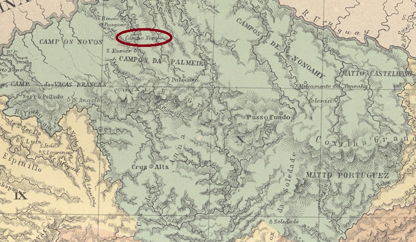
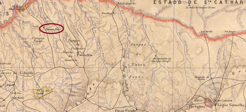
Campo Novo was a settlement belonging to the Vila de Cruz Alta on the west bank of the Turvo, 440 km northwest of the provincial capital Porto Alegre. In March 1875, the village was annexed to the newly founded Município of Sto. Antonio da Palmeira and became a district of the Município Três Passos in December 1944. Since January 1959, Campo Novo has been an independent municipality.
According to the Directory of Imperial Post Offices (Tabella das Agencias do Correio do Imperio, Rio de Janeiro, 1885), there was a post office there from 1883. No imperial postmarks have been seen so far.
Estado do Rio Grande do Sul, 1891
Campo Novo war eine zur Vila de Cruz Alta gehörende Siedlung am Westufer des Turvo, 440 km nordwestlich der Provinzhauptstadt Porto Alegre. Im März 1875 wurde der Ort dem neu gegründeten Município von Sto. Antonio da Palmeira und wurde im Dezember 1944 ein Distrikt des Município Três Passos. Seit Januar 1959 ist Campo Novo eine eigenständige Gemeinde.
Wie aus dem Verzeichnis der kaiserlichen Postämter (Tabella das Agencias do Correio do Imperio, Rio de Janeiro, 1885) hervorgeht, gab es dort ab 1883 ein Postamt. Bisher wurden keine kaiserlichen Poststempel gesehen.
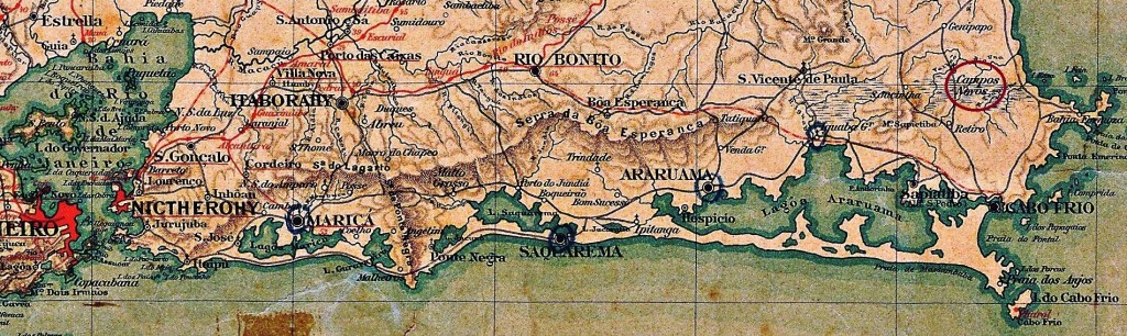
Bellegard-Nieleyer: Carta Corographica da Provincia do Rio de Janeiro, 1867
Other names: Campos Novos, Tamoios
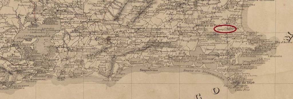
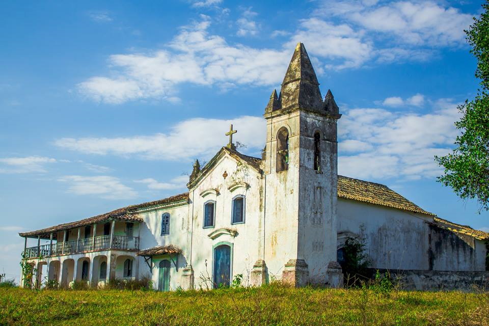
Campos Novos (New Fields) was the name of a fazenda near Cabo Frio, 180 km east of the capital Rio de Janeiro, around 1860. A small settlement slowly developed around this fazenda. In December 1938, it became a district, which five years later received the name Tamoios, which is still valid today.
St. Inácio Church, Fazenda Campos Novos (Photo: IPHAN)
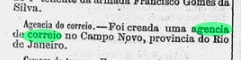
Three dates could be found for the creation of the Imperial Post Office. The first was in July 1863, according to the Rio press:
Diario do Rio de Janeiro, 05.07.1863
Paulo Novaes mentions a date in November of the same year for it in agenciaspostais.com.br. And finally, Nova Monteiro lists the agency with a date of June 1867 in Administrações e Agencias Postaes do Brasil Imperio (Brasil Filatelico/RJ, 1934-5; reprint SPP 1994-1999).
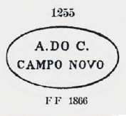
The first cancel CRJ-0280a was already made known by Paulo Ayres (Catálogo de Carimbos Brasil-Império, S. Paulo, 1937, 1942) under no. 1255. Curiously, the place name is written here in the singular (CAMPO NOVO).
CRJ-0280a (P.A. 1255)
Reinhold Koester also mentions a postmark as a double circle in Carimbologia VIII, unfortunately without illustration. This would be CRJ-0280b and we remain wondering whether the place name can now be read correctly.
Almanak Laemmert, 1892
Andere Namen: Campos Novos, Tamoios
Campos Novos (Neue Felder) war um 1860 der Name einer Fazenda bei Cabo Frio, 180 km östlich der Hauptstadt Rio de Janeiro. Um diese Fazenda herum entwickelte sich langsam eine kleine Siedlung. Im Dezember 1938 wurde daraus ein Distrikt, der fünf Jahre später den bis heute gültigen Namen Tamoios erhielt.
Fazenda Campos Novos, St. Inácio-Kirche (Foto: IPHAN)
Für die Gründung des örtlichen kaiserlichen Postamtes konnten drei Daten gefunden werden. Zum ersten Mal im Juli 1863, wie aus der Presse von Rio hervorgeht:
Diario do Rio de Janeiro, 05.07.1863
Paulo Novaes erwähnt stattdessen ein Datum aus November desselben Jahres in agenciaspostais.com.br. Und schließlich listet Niva Monteiro die Agentur mit einem Datum vom Juni 1867 in Administrações e Agencias Postaes do Brasil Imperio (Brasil Filatelico/RJ, 1934-5; Nachdruck SPP 1994-1999) auf.
Der erste Stempel CRJ-0280a wurde bereits von Paulo Ayres (Catálogo de Carimbos Brasil-Império, S. Paulo, 1937, 1942) unter der Nr. 1255 bekannt gemacht.
CRJ-0280a (P.A. 1255)
Merkwürdigerweise wird hier der Ortsname im Singular geschrieben (CAMPO NOVO). Reinhold Koester erwähnt auch einen Poststempel als Doppelkreis in Carimbologia VIII, leider ohne Abbildung. Dieser wäre CRJ-0280b und wir bleiben gespannt, ob der Ortsname hier richtig zu lesen ist.
Other names: Senhor Bom Jesus do Ribeirão das Antas, Bueno Brandão (1938).
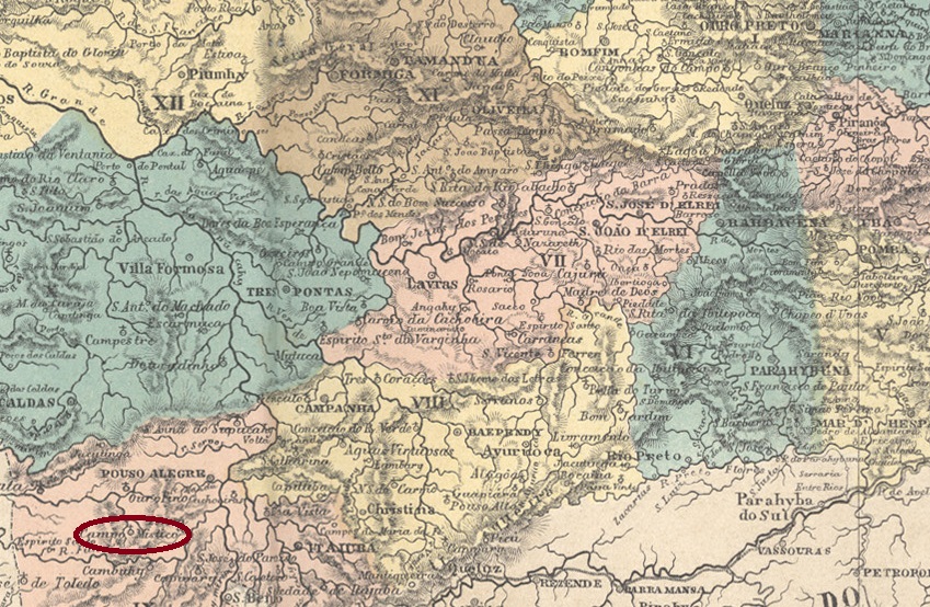
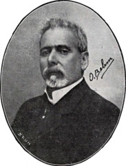
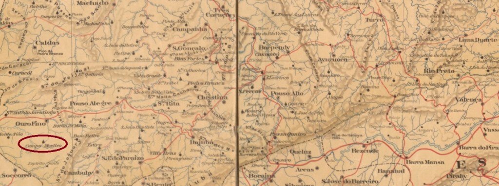
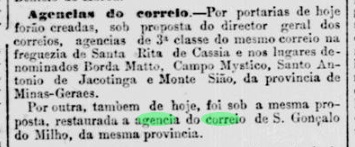
The former chapel of Senhor Bom Jesus do Ribeirão das Antas belonged to the Vila of Ouro Fino and was located on the north bank of the Antas River, 500 km southwest of the provincial capital of Ouro Preto. In June 1850, the village was elevated to a freguesia, with the strange name Campo Mystico (Mystic Field). It remained so until December 1938, when autonomy came as a município, now under the name Bueno Brandão. The latter commemorates the Ouro Fino-born politician Júlio Bueno Brandão (1858-1931), who was twice president of the state of Minas Gerais at the beginning of the Republic.
Biblioteca Nacional (Fon-Fon)
As the Rio press reported, there had been a post office there since the beginning of July 1881:
Jornal do Commercio/RJ, 02.07.1881
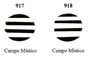
The first postmark CMG-0520a is known so far with dates between 1885 and 1896, exists also in blue and dark violet and was already presented by R. Koester in Carimbologia VIII:
CMG-0520a (RK) 1885-1896
James Dingler and Klerman W. Lopes also found two mute cancellations from there and registered them as Nos. 917 and 918 in Mute Cancellations of the Brazil Empire / Carimbos Mudos do Brasil Império (Brazil Philatelic Association, Rio de Janeiro, 2000):
BPA 917-918 (1881ff-1885)Estado de Minas Geraes, 1910
Andere Namen: Senhor Bom Jesus do Ribeirão das Antas, Bueno Brandão (1938)
Die ehemalige Kapelle von Senhor Bom Jesus do Ribeirão das Antas gehörte zur Vila von Ouro Fino und lag am Nordufer des Antas-Flusses, 500 km südwestlich der Provinzhauptstadt Ouro Preto. Im Juni 1850 wurde das Dorf zur Freguesia erhoben, mit dem seltsamen Namen Campo Mystico (Mystisches Feld). So blieb es bis Dezember 1938, als die Autonomie als Município, nun unter dem Namen Bueno Brandão, kam. Letzterer erinnert an den in Ouro Fino geborenen Politiker Júlio Bueno Brandão (1858-1931), der zu Beginn der Republik zweimal Präsident des Bundesstaates Minas Gerais war.
Biblioteca Nacional (Fon-Fon)
Wie die Presse in Rio berichtete, gab es dort seit Anfang Juli 1881 ein Postamt:
Jornal do Commercio/RJ, 02.07.1881
Der erste Poststempel CMG-0520a ist bisher mit Daten zwischen 1885 und 1896 bekannt, existiert auch in blau und dunkelviolett und wurde von R. Koester bereits in Carimbologia VIII vorgestellt:
CMG-0520a (RK) 1885-1896
James Dingler und Klerman W. Lopes fanden auch zwei stumme Entwertungen von dort und registrierten sie als Nr. 917 und 918 in Mute Cancellations of the Brazil Empire / Carimbos Mudos do Brasil Império (Brazil Philatelic Association, Rio de Janeiro, 2000):
Villiers de l’Ile Adam: Carta (…) da Provincia do Piauhy, 1850
Text update of November 17, 2023
Another name: Santo Antonio do Surubim
The old freguesia of Santo Antonio do Surubim was founded around 1700 on the east bank of the Surubim, just 80 km northeast of the later provincial capital of Teresina. As early as June 1761, it was elevated to the status of Vila de Campo Maior. In the following period, the village probably continued to develop, as it was on the way from the capital to the Atlantic coast.
Three dates have been found for the opening of post offices. First in September 1817, as Nova Monteiro writes in Administrações e Agencias Postaes do Brasil Imperio (Brasil Filatelico/RJ, 1934-5; Reprint SPP 1994-1999), making Campo Maior one of the oldest post offices in the later province. Then 1823, as can be read in Koester’s Carimbologia VIII. And finally 1876, as stated in the Directory of Imperial Post Offices (Tabella das Agencias do Correio do Imperio, Rio de Janeiro, 1885). When the agency closed in the meantime is not known, only that it was in operation in 1839, 1847, 1856 and 1864.
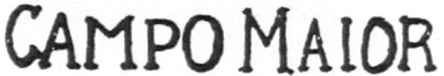
The oldest postmark to date is CPI-0050a (Abb. Henrique B. Ferreira), which was used on Bull’s Eyes issues:
CPI-0050a (HBF) 1843ff
Then came CPI-0050b (Fig. Jorge L. Pedreira), found with a date of 1881:
CPI-0050b (JLP) 1881
It is followed by CPI-0050c (Fig. Luiz C. Fritzen), known with a date of 1899:
CPI-0050c (LCF) 1899Atlas do Imperio do Brasil, 1868
Textaktualisierung am 17. November 2023
Anderer Name: Santo Antonio do Surubim
Die alte Freguesia von Santo Antonio do Surubim entstand um 1700 am Ostufer des Surubim, knapp 80 km nordöstlich der späteren Provinzhauptstadt Teresina. Bereits im Juni 1761 wurde sie zur Vila de Campo Maior erhoben. In der Folgezeit dürfte sich der Ort weiterentwickelt haben, da er auf dem Weg von der Hauptstadt zur Atlantikküste lag.
Es wurden drei Daten für die Eröffnung von Postämtern gefunden. Zum ersten Mal im September 1817, wie Nova Monteiro in Administrações e Agencias Postaes do Brasil Imperio (Brasil Filatelico/RJ, 1934-5; Reprint SPP 1994-1999) schreibt, womit Campo Maior zu den ältesten Postämtern der späteren Provinz gehört. Dann 1823, wie in Koesters Carimbologia VIII zu lesen ist. Und schließlich 1876, wie im Verzeichnis der kaiserlichen Postämter (Tabella das Agencias do Correio do Imperio, Rio de Janeiro, 1885) angegeben. Wann die Agentur zwischenzeitlich geschlossen wurde, ist nicht bekannt, nur dass sie 1839, 1847, 1856 und 1864 in Betrieb war.
Der bisher älteste Stempel ist CPI-0050a (Abb. Henrique B. Ferreira), der auf Ochsenaugen-Ausgaben verwendet wurde:
CPI-0050a (HBF) 1843ff
Dann kam CPI-0050b (Abb. Jorge L. Pedreira), gefunden mit einem Datum von 1881:
CPI-0050b (JLP) 1881
Ihm folgte CPI-0050c (Abb. Luiz C. Fritzen), bekannt mit einem Datum von 1899:
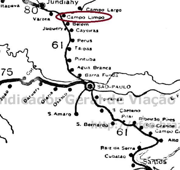
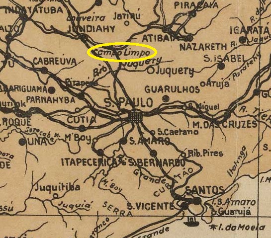
Cia. Sorocabana, Ytuana e S. Paulo Railway, 1898 (IBGE)
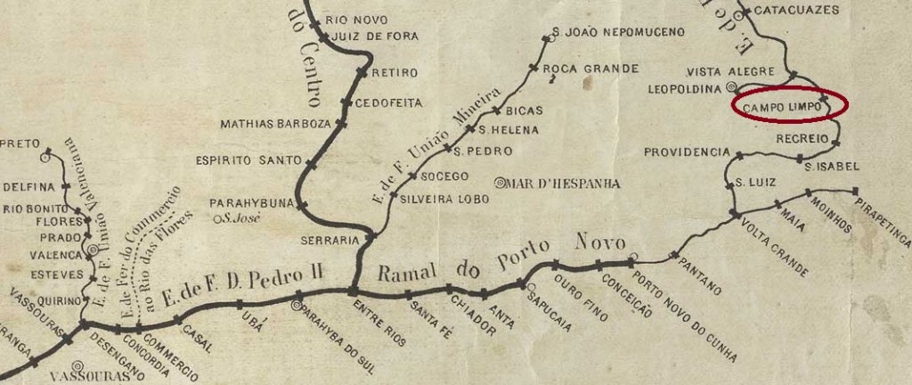
Other name: Campo Limpo Paulista (1964)
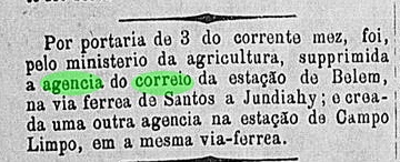
Campo Limpo station was opened by the São Paulo Railway in January 1881 in the Município Jundiaí on the south bank of the river of the same name, 60 km north of the provincial capital São Paulo. Afterwards, the line changed hands four times: in 1846 to E.F. Santos a Jundiaí, in 1975 to Rede Ferroviária Federal S.A., in 1983 to Cia. Brasileira de Transportes Urbanos and since 1992 it has been operated by the Cia. Paulista de Transportes Metropolitanos (CPTM) (estacoesferroviarias.com.br). The area around the station was elevated to a district in December 1953 and has been a município called Campo Limpo Paulista since February 1964.
As the regional press reported, there had been a post office at the station since May 1884:
Correio Paulistano, 6 May, 1884
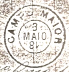
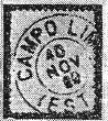
The only postmark in the Empire so far CSP-0255a also existed in blue and was already presented by R. Koester in Carimbologia VIII:
CSP-0255a (RK) 1889Arthur D. Ribeiro: Estado de São Paulo, 1924
Anderer Name: Campo Limpo Paulista (1964)
Der Bahnhof Campo Limpo wurde im Januar 1881 von der São Paulo Railway eröffnet und lag im Município Jundiaí am Südufer des gleichnamigen Flusses, 60 km nördlich der Provinzhauptstadt São Paulo. Danach wechselte die Strecke viermal den Besitzer: 1846 an die E.F. Santos a Jundiaí, 1975 an die Rede Ferroviária Federal S.A., 1983 an die Cia. Brasileira de Transportes Urbanos und seit 1992 wird sie von der Cia. Paulista de Transportes Metropolitanos (CPTM) betrieben (estacoesferroviarias.com.br). Das Gebiet um den Bahnhof wurde im Dezember 1953 zum Distrikt erhoben und ist seit Februar 1964 ein Município mit dem Namen Campo Limpo Paulista.
Wie die regionale Presse berichtete, gab es seit Mai 1884 ein Postamt am Bahnhof:
Correio Paulistano, 06.05.1884
Der bisher einzige Poststempel im Kaiserreich CSP-0255a gab es auch in blau und wurde bereits von R. Koester in Carimbologia VIII vorgestellt:
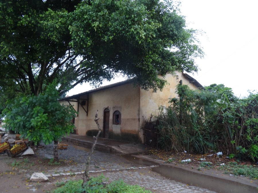
The small Campo Limpo station was opened in September 1873 by the railway company E.F. Campos a São Sebastião in the Município Campos, 280 km northeast of the capital Rio de Janeiro. Afterwards, the line changed hands three times: in 1889 to E.F. Macaé e Campos, around 1900 to E.F. Leopoldina and in 1975 to Rede Ferroviária Federal S.A., which ceased operations in 1996 (estacoesferroviarias.com.br). Today the tracks have disappeared, the station building stands and looks a bit run down.
In 2016 (Photo: Fernando Marietan, on estacoesferroviarias.com.br)
As the postal bulletin (Boletim Postal) of December 1889 states, the station post office was created on 14 November 1889, the last day of the Brazilian Empire. It would be a miracle if there was a postmark from that time.
agenciaspostais.com.br
Anderer Name: Tahy/Taí (1928)
Der kleine Bahnhof Campo Limpo wurde im September 1873 von der Eisenbahngesellschaft E.F. Campos a São Sebastião eröffnet und lag im Município Campos, 280 km nordöstlich der Hauptstadt Rio de Janeiro. Danach wechselte die Strecke dreimal den Besitzer: 1889 an E.F. Macaé e Campos, um 1900 an E.F. Leopoldina und 1975 an die Rede Ferroviária Federal S.A., die den Betrieb 1996 einstellte (estacoesferroviarias.com.br). Heute sind die Gleise verschwunden, das Bahnhofsgebäude steht und sieht etwas heruntergekommen aus.
2016 (Foto: Fernando Marietan, auf estacoesferroviarias.com.br)
Wie im Postbulletin (Boletim Postal) vom Dezember 1889 zu lesen ist, wurde das Bahnhofspostamt am 14. November 1889 ins Leben gerufen, dem letzten Tag des brasilianischen Kaiserreichs. Es wäre ein Wunder, wenn es einen Poststempel aus dieser Zeit gäbe.
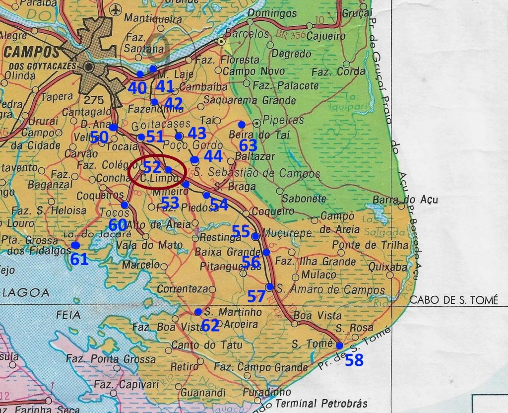
The Freguesia de Campo Limpo was founded in October 1878, belonged to the Vila de Leopoldina and was located on the south bank of the Pomba, 250 km southeast of the provincial capital Ouro Preto. Since December 1948, the town has borne the name Ribeiro Junqueira, in memory of Francisco Ribeiro Junqueira (1841-1921), a military man and politician from Minas Gerais, who was elevated to Baron of Cristina at the end of the Empire:
Wikidata
The Directory of Imperial Post Offices (Tabella das Agencias do Correio do Imperio, Rio de Janeiro, 1885) states that there had been a post office there since 1870, but it belonged to a railway station. However, this was not opened until July 1874 by the E.F. Leopoldina railway company (main line). This could mean that the post office had already existed in the Freguesia since 1870 and was moved to the railway station after the arrival of the railway line. This hypothesis is supported by Paula Sobrinho, who writes in História Postal de Minas Gerais (Belo Horizonte, 1997) that a post office was inaugurated in July 1881 at Campo Limpo station.
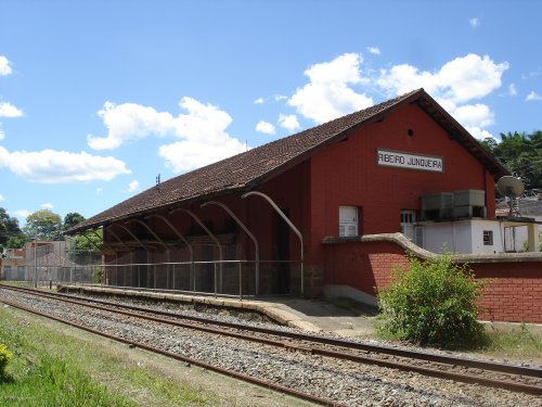
The railway line passed to Rede Ferroviária Federal S.A. in 1975 and was closed in 1996 (estacoesferroviarias.com.br). The tracks are still there today and the station building seems to be quite well preserved.
In2008 (Photo Gutierrez L. Coelho, on estacoesferroviarias.com.br)
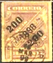
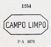
The first postmark CMG-0515a was already shown by Paulo Ayres in the Catálogo de Carimbos Brasil-Império (S. Paulo, 1937, 1942) under No. 1254. It also exists in blue and green, with dates to at least 1878.
CMG-0515a /P.A. 1254)
A railway station postmark is also known from the 19th century: CMG-0516a (Fig. Luiz C. Fritzen) has internal dates of 1892 and 1893.
CMG-0516a (LCF)Estações (…) do Rio de Janeiro, São Paulo e Minas Geraes, 1880
Anderer Name: Ribeiro Junqueira (1948)
Die Freguesia de Campo Limpo wurde im Oktober 1878 gegründet, gehörte zur Vila de Leopoldina und lag am Südufer des Pomba, 250 km südöstlich der Provinzhauptstadt Ouro Preto. Seit Dezember 1948 trägt der Ort den Namen Ribeiro Junqueira, in Erinnerung an Francisco Ribeiro Junqueira (1841-1921), einen Militär und Politiker aus Minas Gerais, der am Ende des Kaiserreichs zum Baron von Cristina erhoben wurde:
Abb. Wikidata
Im Verzeichnis der kaiserlichen Postämter (Tabella das Agencias do Correio do Imperio, Rio de Janeiro, 1885) ist zu lesen, dass es dort seit 1870 ein Postamt gab, das allerdings zu einem Bahnhof gehörte. Dieser wurde aber erst im Juli 1874 von der Eisenbahngesellschaft E.F. Leopoldina (Hauptstrecke) eröffnet. Dies könnte bedeuten, dass das Postamt bereits seit 1870 in der Freguesia existierte und nach der Ankunft der Eisenbahnlinie zum Bahnhof verlegt wurde. Diese Hypothese wird von Paula Sobrinho unterstützt, die in História Postal de Minas Gerais (Belo Horizonte, 1997) schreibt, dass ein Bahnhofspostamt in Campo Limpo im Juli 1881 eingeweiht wurde.
Die Bahnlinie ging 1975 an die Rede Ferroviária Federal S.A. über und wurde 1996 stillgelegt (estacoesferroviarias.com.br). Die Gleise sind heute noch vorhanden und das Bahnhofsgebäude scheint recht gut erhalten zu sein.
2008 (Foto: Gutierrez L. Coelho auf estacoesferroviarias.com.br)
Der erste Poststempel CMG-0515a wurde bereits von Paulo Ayres im Catálogo de Carimbos Brasil-Império (S. Paulo, 1937, 1942) unter Nr. 1254 gezeigt. Es gibt ihn auch in blau und grün, mit Daten bis mindestens 1878.
CMG-0515a (P.A. 1254) 1870-1878ff
Aus dem 19. Jahrhundert ist auch ein Bahnhofspoststempel bekannt:
CMG-0516a (Abb. Luiz C. Fritzen) hat innere Daten von 1892 und 1893.
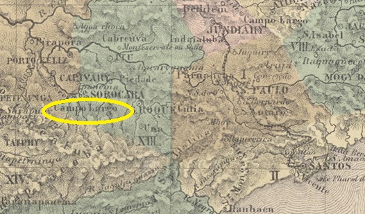
Other names: Campo Largo de Sorocaba, Araçoiaba da Serra (1944)
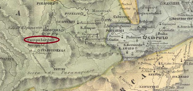
The parish of N. Sra. das Dores do Campo Largo was founded in August 1817 and belonged to the Vila de Sorocaba, 120 km west of the later provincial capital of São Paulo. It was declared a freguesia in February 1821 and a vila in April 1857, most recently under the name Campo Largo de Sorocaba. Between July 1934 and November 1936, it was downgraded to the district of Sorocaba before regaining município status, first under the name Campo Largo, and since November 1944, the small town has been called Araçoiaba da Serra. The Indian term Araçoiaba means “sun haven” and refers to a mountain in the region.
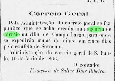
As the regional press reports, there has been a post office there since May 1866:
Diario de São Paulo, 12 May 1866
So far, no postmark from the imperial period could be assigned to this place.
Villers de l’Ile Adam: Carta (…) da Provincia de São Paulo, 1847
Andere Namen: Campo Largo de Sorocaba, Araçoiaba da Serra (1944)
Die Pfarrei N. Sra. das Dores do Campo Largo wurde im August 1817 gegründet und gehörte zur Vila de Sorocaba, 120 km westlich der späteren Provinzhauptstadt São Paulo. Es wurde im Februar 1821 zur Freguesia und im April 1857 zur Vila erklärt, zuletzt unter dem Namen Campo Largo de Sorocaba. Zwischen Juli 1934 und November 1936 wurde der Ort zum Distrikt von Sorocaba herabgestuft, bevor er wieder den Status eines Município erhielt, zunächst unter dem Namen Campo Largo, und seit November 1944 heißt die Kleinstadt Araçoiaba da Serra. Der indianische Begriff Araçoiaba bedeutet “Sonnenhort” und bezieht sich auf einen Berg der Region.
Wie die Regionalpresse berichtete, gab es dort seit Mai 1866 ein Postamt:
Diario de São Paulo, 12.05.1866
Bisher konnte noch kein Poststempel aus der Kaiserzeit diesem Ort zugeordnet werden.