Categories
Carimbologia C-D

Campina Grande, Paraná (CPR-0030)

Estado do Paraná, 1892

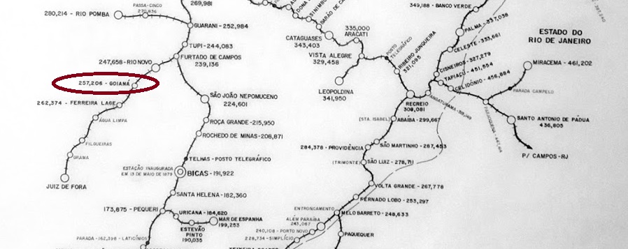
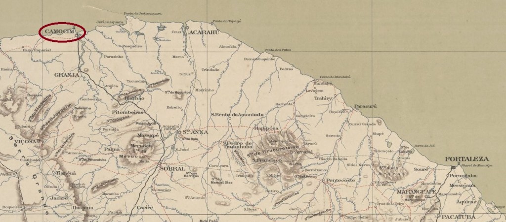
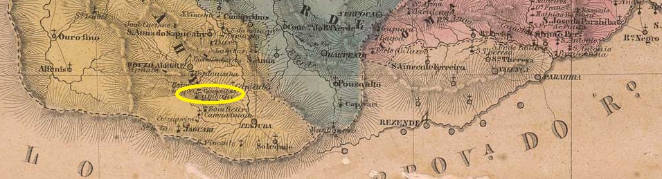
Other names: Glycerio, Timbu, Campina Grande do Sul

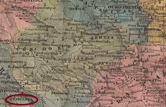
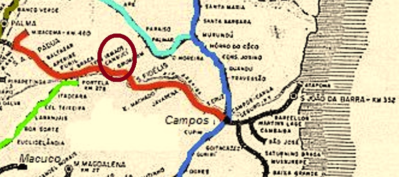
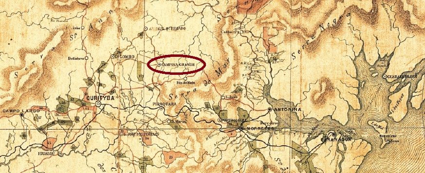
The Freguesia de S. João Baptista da Campina Grande was founded in April 1873 around the Vila do Arraial Queimado, 25 km northeast of the provincial capital Curitiba. In November 1883, the village was elevated to the status of a vila with its own município. Two name changes followed: in February 1890 to Glycerio and in November 1891 again to Campina Grande. In October 1938, Campina Grande was downgraded to the district of the Município Piraquara and in December 1943 it was renamed again, this time to Timbu. Under this name, it was upgraded to Município in November 1951. Finally, in February 1956, this Município was given the name Campina Grande do Sul, which is still valid today.

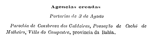
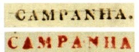
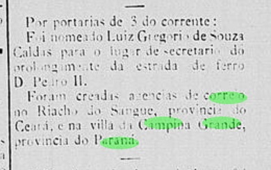
According to the capital’s press, the local post office was founded in June 1884:

Diario do Brazil/RJ, 06.06.1884

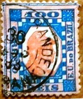
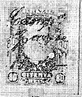
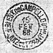
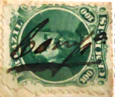
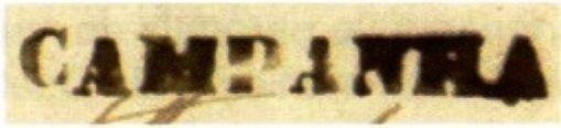
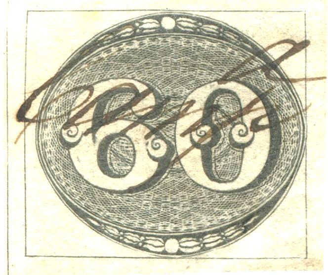
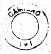
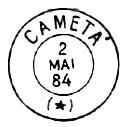
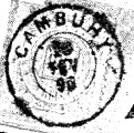
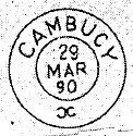
Reinhold Koester showed the imperial postmark CPR-0030a in Carimbologia VIII:

CPR-0030a (RK) 1887

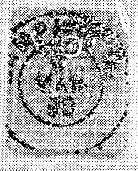
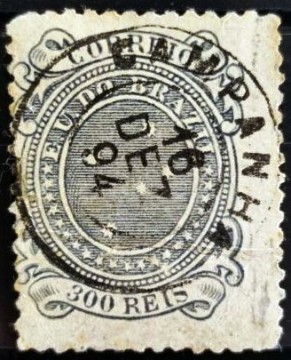
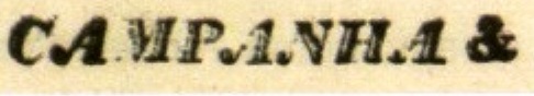
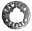
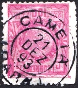
The following postmark CPR-0030b (illustration from the internet) might already be from the time of the Republic:

CPR-0030b (EB) 1893
Estado do Paraná, 1896

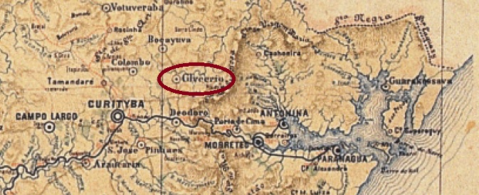
Andere Namen: Glycerio, Timbu, Campina Grande do Sul

Die Freguesia de S. João Baptista da Campina Grande wurde im April 1873 im Gebiet der Vila do Arraial Queimado, 25 km nordöstlich der Provinzhauptstadt Curitiba, gegründet. Im November 1883 wurde der Ort zur Vila mit eigenem Município erhoben. Es folgten zwei Namensänderungen: im Februar 1890 in Glycerio und im November 1891 wieder in Campina Grande. Im Oktober 1938 wurde Campina Grande zum Distrikt des Município Piraquara herabgestuft und im Dezember 1943 erneut umbenannt, diesmal in Timbu. Unter diesem Namen erfolgte im November 1951 die Aufwertung zum Município. Schließlich erhielt dieser Município im Februar 1956 den noch heute gültigen Namen Campina Grande do Sul.

Wie aus der Presse der Hauptstadt hervorgeht, wurde das örtliche Postamt im Juni 1884 gegründet:

Diario do Brazil/RJ, 06.06.1884

Reinhold Koester zeigte in Carimbologia VIII den kaiserlichen Poststempel CPR-0030a:

CPR-0030a (RK) 1887

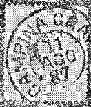
Der folgende Stempel CPR-0030b (Abbildung aus dem Internet) dürfte bereits aus der Zeit der Republik stammen:

CPR-0030b (EB) 1893
Categories
Carimbologia C-D

Campina Grande, Paraíba (CPB-0100)

Atlas do Imperio do Brasil, 1868

See also Villa Nova da Rainha (VPB-0295)

The freguesia of N. Sra. da Conceição de Campina Grande was established in 1769, situated 120 km west of the future provincial capital Parahyba do Norte (today: João Pessoa). It was promoted to Villa Nova da Rainha by royal decree (Alvará Real) in August 1788 and retained this name for almost 80 years. It was not until October 1864, when it was granted city status, that it was renamed Campina Grande.

There had been a post office there since May 1829, as can be read both in the postal report (Relatorio Postal) for 1887 and in the directory of imperial post offices (Tabella das Agencias do Correio do Imperio, Rio de Janeiro, 1885). So far, no postmark with the old place name has turned up. Reinhold Koester has shown a postmark and a handwritten cancellation from Campina Grande in Carimbologia VIII:

CPB-0100b (RK) 1886
1877ff (RK)
Villiers de l’Ile Adam: Carta das Provincias do Rio Grande do Norte e Parahiba, 1848

Siehe auch Villa Nova da Rainha (VPB-0295)

Die Freguesia von N. Sra. da Conceição de Campina Grande wurde 1769 errichtet und lag 120 km westlich der künftigen Provinzhauptstadt Parahyba do Norte (heute: João Pessoa) entfernt. Sie stieg im August 1788 durch königliche Verfügung (Alvará Real) zur Villa Nova da Rainha auf und behielt diesen Namen immerhin fast 80 Jahre lang. Erst im Oktober 1864, bei der Vergabe des Stadt-Status, wurde der Ort zu Campina Grande umbenannt.

Dort gab es ein Postamt seit Mai 1829, wie man sowohl im Postbericht (Relatorio Postal) für 1887 als auch im Verzeichnis der kaiserlichen Postämter (Tabella das Agencias do Correio do Imperio, Rio de Janeiro, 1885) lesen kann. Bisher ist noch kein Poststempel mit der alten Ortsbezeichnung aufgetaucht. Reinhold Koester hat in Carimbologia VIII einen Poststempel und eine handschriftliche Entwertung  mit Campina Grande gezeigt:

CPB-0100b (RK) 1886
1877ff (RK)
Categories
Carimbologia C-D

Campestre, Bahia (CBA-0223)

Carta da Republica dos Estados Unidos do Brazil, 1892

Other names: Doutor Seabra, Seabra (1931)

The Freguesia de N. Sra. da Conceição do Campestre was founded in May 1863 on the north bank of the Cochó, 460 km west of the provincial capital Salvador da Bahia, and belonged to the Vila de Lençóis. The village became a Vila Agrícola in May 1889 and a town in June 1891, renamed Doutor Seabra in August 1915 and simply Seabra since June 1931. The name commemorates José Joaquim Seabra (1855-1942), who was twice governor of the state of Bahia: from 1912 to 1916 and from 1920 to 1924. 

J.J. Seabra (Image: Wikipedia)

As can be seen from the postal bulletin of September 1889, there was a post office in Campestre from August of that year:

Boletim Postal No. 5, September 1889

No imperial postmark has yet been seen from this place; it must be very rare.

Estado da Bahia, 1913

Andere Namen: Doutor Seabra, Seabra (1931)

Die Freguesia de N. Sra. da Conceição do Campestre wurde im Mai 1863 gegründet, lag am Nordufer des Cochó, 460 km westlich der Provinzhauptstadt Salvador da Bahia und gehörte zur Vila de Lençóis. Das Dorf wurde im Mai 1889 zur Vila Agrícola und im Juni 1891 zur Stadt, die im August 1915 in Doutor Seabra umbenannt wurde und seit Juni 1931 einfach Seabra heißt. Der Name erinnert an José Joaquim Seabra (1855-1942), der zweimal Gouverneur des Staates Bahia war: von 1912 bis 1916 und von 1920 bis 1924. 

J.J. Seabra (Bild: Wikipedia)

Wie aus dem Postbulletin vom September 1889 hervorgeht, gab es in Campestre seit August desselben Jahres ein Postamt:

Boletim Postal Nr. 5, September 1889

Bisher wurde noch kein kaiserlicher Poststempel aus diesem Ort gesehen; er muss sehr selten sein.

Categories
Carimbologia C-D

Campello (train station/Bahnhof), Minas Gerais (CMG-0500)

Estado de Minas Gerais, 1910

Other names: Capim, Desembargador Lemos, Limoeiro, Goianá (1911)

Campello station was originally called Capim, opened in July 1883 by the railway company E.F. de Juiz de Fora a Piau and located on the south bank of the Rio Novo near the vila of the same name, 240 km south of the provincial capital Ouro Preto. The following year, the line became the property of the E.F. Leopoldina and was closed in 1974. The station building is now demolished and the tracks removed. In the following decades, the name changed several times: to Desembargador Lemos (ca. 1890), Limoeiro – after the nearby settlement of Santo Antonio do Limoeiro (ca. 1900) and Goianá (1911). Under the last name, the area became a district and has been an independent município since December 1995.

The post office at this station is an enigma. Both R. Koester (Carimbologia VIII) and Paula Sobrinho (História Postal de Minas Gerais, Belo Horizonte, 1997) write that there had been a postal agency there since July 1881, two years before the station was opened. The Directory of Imperial Post Offices (Tabella das Agencias do Correio do Imperio, Rio de Janeiro, 1885) also mentions a Capim station post office – unfortunately without a creation year – but the postal report (Relatorio Postal) at the end of 1886 no longer does, although Estação do Capim was already present in the regional press in March 1881:

 O Pharol, 17 March 1881

Thus, a Capim post office may have existed from 1881 to about 1885. Sure is that the postal agency was opened at Campello station at the end of 1887:

O Pharol, 19 December 1887

And that Campello station was identical to the Capim station:

A União, 14 December 1887

So far, no postmark has been seen from the Capim station. R. Koester (op. cit.) showed us the imperial postmark of Campello station under CMG-0500a:

CMG-0500a (RK) 1888-1889
Estrada de Ferro Leopoldina – MG

Andere Namen: Capim, Desembargador Lemos, Limoeiro, Goianá (1911)

Der Bahnhof Campello hieß ursprünglich Capim, wurde im Juli 1883 von der Eisenbahngesellschaft E.F. de Juiz de Fora a Piau eröffnet und lag am Südufer des Rio Novo nahe der gleichnamigen Vila, 240 km südlich der Provinzhauptstadt Ouro Preto. Im folgenden Jahr ging die Strecke in den Besitz der E.F. Leopoldina über und wurde 1974 stillgelegt. Das Bahnhofsgebäude wurde inzwischen abgerissen, und die Gleise entfernt. In den folgenden Jahrzehnten änderte sich der Name mehrmals: Desembargador Lemos (ca. 1890), Limoeiro – nach der nahe gelegenen Siedlung Santo Antonio do Limoeiro (ca. 1900) und Goianá (1911). Mit dem letztgenannten Ortsnamen wurde das Gebiet zum Distrikt und ist seit Dezember 1995 ein eigenständiges Município.

Kopfzerbrechen bereitet das Postamt an diesem Bahnhof. Sowohl R. Koester (Carimbologia VIII) als auch Paula Sobrinho (História Postal de Minas Gerais, Belo Horizonte, 1997) schreiben, dass es dort seit Juli 1881 eine Postagentur gab, zwei Jahre vor der Inbetriebnahme des Bahnhofs. Auch im Verzeichnis der kaiserlichen Postämter (Tabella das Agencias do Correio do Imperio, Rio de Janeiro, 1885) wird ein Bahnhofspostamt Capim erwähnt – leider ohne Jahresangabe für dessen Entstehung-, im Postbericht (Relatorio Postal) Ende 1886 jedoch nicht mehr, obwohl der Begriff Estação do Capim bereits im März 1881 in der regionalen Presse zu lesen war:

 O Pharol, 17. März 1881

Daraus folgt, dass ein Postamt Capim von 1881 bis etwa 1885 bestanden haben könnte. Sicher ist, dass Ende 1887 die Postagentur am Bahnhof von Campello eröffnet wurde:

O Pharol, 19. Dezember 1887

Und dieser Bahnhof Campello war identisch mit dem Bahnhof Capim:

A União, 14. Dezember 1887

Bisher wurde kein Poststempel von der Station Capim gesehen. R. Koester (op. cit.) zeigte uns den kaiserlichen Poststempel des Bahnhofs Campello mit CMG-0500a:

CMG-0500a (RK) 1888-1889
Categories
Carimbologia C-D

Campanha (CMG-0495) – Campanha da Princeza, Minas Gerais (CMG-3775)

Atlas do Imperio do Brasil, 1868

Other names: Campanha do Rio Verde, Campanha da Princesa da Beira

The Freguesia de Campanha do Rio Verde was founded in 1752 on the south bank of the Riacho Santo Antonio near the Vila de S. João d’El-Rei, 360 km southwest of the later provincial capital Ouro Preto. In September 1798 it became the Vila de Campanha da Princesa da Beira and in March 1840 a town with the shortened place name Campanha.

Two creation dates have been found for the local post office. Nova Monteiro gives March 1829 in Administrações e Agencias Postaes do Brasil Imperio (Brasil Filatelico/RJ, 1934-5; reprinted SPP 1994-1999). A date two decades earlier – May 1809 – was given by Paula Sobrinho in História Postal de Minas Gerais (Belo Horizonte, 1997). His dating could be correct as many covers are dated 1826 or earlier from the pre-philatelic period and bear different postmarks:

CMG-3775a (RHM P-MG-17) sepia
CMG-3775b (RHM P-MG-16) 1826 red
CMG-0495a (RHM P-MG-12) 1835-1843ff, tb sepia (4.2 cm long)
CMG-0495b (RHM P-MG-13) 3.0 cm long
CMG-0495c (RHM P-MG-14) 2.1 cm long
CMG-0495d (RHM P-MG-15) 4.2 cm long

After that came – as R. Koester already noted in Carimbologia VIII – a longer period in which the letters were apparently cancelled only by hand.

1843ff (ill. Claudio Coelho)

1866ff (ill. Antonio Eleftheriou)

The next cancel CMG-0495e (ill. from the Internet) came only in the 1980s:

CMG-0495e (EB) 1885ff-1894

From Campanha there also comes a mute cancellation recorded by James Dingler and Klerman W. Lopes in Mute Cancellations of the Brazil Empire / Carimbos Mudos do Brasil Império (Brazil Philatelic Association, Rio de Janeiro, 2000) with no. 458.

BPA 458, 1873-1878ff
Villiers de l’Ile Adam: Carta (…) da Provincia de Minas Geraes, 1849

Andere Namen: Campanha do Rio Verde, Campanha da Princesa da Beira

Die Freguesia de Campanha do Rio Verde wurde 1752 am Südufer des Riacho Santo Antonio in der Nähe der Vila de S. João d’El-Rei, 360 km südwestlich der späteren Provinzhauptstadt Ouro Preto gegründet. Im September 1798 wurde es zur Vila de Campanha da Princesa da Beira und im März 1840 zur Stadt mit dem gekürzten Ortsnamen Campanha.

Für das örtliche Postamt wurden zwei Gründungsdaten gefunden. Nova Monteiro nennt den März 1829 in Administrações e Agencias Postaes do Brasil Imperio (Brasil Filatelico/RJ, 1934-5; Nachdruck SPP 1994-1999). Ein zwei Jahrzehnte früheres Datum – Mai 1809 – wurde von Paula Sobrinho in História Postal de Minas Gerais (Belo Horizonte, 1997) angegeben. Seine Datierung könnte korrekt sein, da viele Belege aus der Vorphila-Periode (1826 oder früher) datiert sind und verschiedene Poststempel tragen:

CMG-3775a (RHM P-MG-17) sepia
CMG-3775b (RHM P-MG-16) 1826 rot
CMG-0495a (RHM P-MG-12) 1835-1843ff, tb sepia (4,2 cm lang)
CMG-0495b (RHM P-MG-13) 3,0 cm lang
CMG-0495c (RHM P-MG-14) 2,1 cm lang
CMG-0495d (RHM P-MG-15) 4,2 cm lang

Danach kam – wie R. Koester in Carimbologia VIII bereits bemerkte – eine längere Periode, in der die Marken anscheinend nur noch handschriftlich entwertet wurden.

1843ff (Abb. Claudio Coelho)

1866ff (Abb. Antonio Eleftheriou)

Der nächste Stempel CMG-0495e (Abb. aus dem Internet) kam erst in den 80er Jahren:

CMG-0495e (EB) 1885ff-1894

Aus Campanha stammt auch eine stumme Entwertung, die von James Dingler und Klerman W. Lopes in Mute Cancellations of the Brazil Empire / Carimbos Mudos do Brasil Império (Brazil Philatelic Association, Rio de Janeiro, 2000) mit der Nr. 458 erfasst wurde.

BPA 458, 1873-1878ff
Categories
Carimbologia C-D

Camocim, Ceará (CCE-0070)

Carta da Republica dos Estados Unidos do Brazil, 1892

Founded in September 1873, the Freguesia de Bom Jesus dos Navegantes de Camocim, which belonged to the Vila de Granja, was located on the western bank of the mouth of the Curiaú into the Atlantic, 360 km west of the provincial capital Fortaleza. As R. Koester writes in Carimbologia VII, the village, which was not even marked on the 1868 map, experienced rapid population growth from May 1877 onwards due to the influx of refugees from the drought areas in the hinterland. As early as September 1879, Camocim was elevated to the status of a vila and ten years later to that of a town.

Koester (op. cit.) writes that the establishment of a local post office was ordered in July 1881. This is confirmed by the provincial president’s report of December of the same year.

Relatorio do Presidente da Provincia/CE, December 1881

The oldest postmark so far is CCE-0070a (image from the internet):

CCE-0070a (EB) 1887-1892

Koester also shows us a seal cancel:

CCE-0070b (RK)
Serv. Geologico e Mineralogico, 1910

Die im September 1873 gegründete Freguesia de Bom Jesus dos Navegantes de Camocim, die zur Vila de Granja gehörte, lag am Westufer der Mündung des Curiaú in den Atlantik, 360 km westlich der Provinzhauptstadt Fortaleza. Wie R. Koester in Carimbologia VII schreibt, erlebte der Ort, der auf der Karte von 1868 nicht einmal eingezeichnet war, ab Mai 1877 eine rasante Bevölkerungsentwicklung durch den Zuzug von Flüchtlingen aus den Dürregebieten im Hinterland. Bereits im September 1879 wurde Camocim zur Vila und zehn Jahre später zur Stadt erhoben.

Koester (a.a.O.) schreibt, dass die Einrichtung eines örtlichen Postamts im Juli 1881 angeordnet wurde. Dies wird durch den Bericht des Provinzpräsidenten vom Dezember desselben Jahres bestätigt.

Relatorio do Presidente da Provincia/CE, Dezember 1881

Der bisher älteste Poststempel ist CCE-0070a (Abbildung aus dem Internet):

CCE-0070a (EB) 1887-1892

Koester zeigt uns auch einen Siegelstempel:

CCE-0070b (RK)
Categories
Carimbologia C-D

Camisão, Bahia (CBA-0220)

Villiers de l’Ile Adam: Carta (…) da Provincia da Bahia, 1848

Another name: Ipirá (1931)

The Freguesia de Sant’Anna do Camisão was founded in 1755, belonged to the Vila de Cachoeira and was located on the south bank of the Riacho Grande, 210 km northwest of the provincial capital Salvador da Bahia. In November 1832, it joined the then-founded Vila de Feira de Sant’Anna, became a vila itself in April 1855, and has been the town of Ipirá since July 1931.

As Nova Monteiro writes in Administrações e Agencias Postaes do Brasil Imperio (Brasil Filatelico/RJ, 1934-5; Reprint SPP 1994-1999), there was a post office there since February 1859, and two imperial postmarks were found, unfortunately not the very first one. CBA-0220b (image by R. Koester, in Carimbologia VII) is a French type with dates from about 1885 to 1887.

CBA-0220b (RK) 1885ff-1887

Its successor CBA-0220c (ill. Antonio Torres) is a plain double circle with the inscription CAMISÃO at the top and inner dates from 1887 to 1898.

Atlas do Imperio do Brasil, 1868

Anderer Name: Ipirá (1931)

Die Freguesia de Sant’Anna do Camisão wurde 1755 gegründet, gehörte zur Vila de Cachoeira und lag am Südufer des Riacho Grande, 210 km nordwestlich der Provinzhauptstadt Salvador da Bahia. Im November 1832 kam es zur damals gegründeten Vila de Feira de Sant’Anna, wurde im April 1855 selbst eine Vila und ist seit Juli 1931 die Stadt Ipirá.

Wie Nova Monteiro in Administrações e Agencias Postaes do Brasil Imperio (Brasil Filatelico/RJ, 1934-5; Reprint SPP 1994-1999) schreibt, gab es dort seit Februar 1859 ein Postamt, und es wurden zwei kaiserliche Poststempel gefunden, leider nicht der Allererste. CBA-0220b (Abb. R. Koester, in Carimbologia VII) ist ein französischer Typ mit Daten von ca. 1885 bis 1887.

CBA-0220b (RK) 1885ff-1887

Sein Nachfolger CBA-0220c (Abb.: Antonio Torres) ist ein schlichter Doppelkreis mit der Inschrift CAMISÃO oben und inneren Jahreszahlen von 1887 bis 1898.

Categories
Carimbologia C-D

Cametá, Pará (CPA-0070)

Atlas do Imperio do Brasil, 1868

Another name: Camutá

Vila Viçosa de Santa Cruz de Camutá was founded in December 1635 on the west bank of the Tocantins River, 230 km southwest of the provincial capital Belém do Pará. 301 years later, this event was even worth two special stamps to the Brazilian Post, a commemoration that was otherwise seldom used at the time:

RHM C 103-104, Scott 419-420, MiNo 443-4

Before and after that, things became quieter around the place, which was still elevated to the the town of Cametá in October 1848. The word comes from the Tupi language and is supposed to mean forest elevation.

As Nova Monteiro writes in Administrações e Agencias Postaes do Brasil Imperio (Brasil Filatelico/RJ, 1934-5; Reprint SPP 1994-1999), there was a post office there since March 1829. Three postmarks have been found for the 19th century, unfortunately not the very first one. CPA-0070b, according to R. Koester (Carimbologia VII), would be a double circle with the inscription CAMETÁ above and no ornaments below. He mentioned a copy of it, dated 1881. Its successor CPA-0070c also exists in blue and is already illustrated in Paulo Ayres’ Catálogo de Carimbos Brasil-Império, (S. Paulo, 1937, 1942) on p. 120:

CPA-0070c (P.A. p. 120) 1884-1888

It was followed by CPA-0070d (fig. from the Internet), which could already be Republican, as it shows internal dates from 1890-1893:

CPA-0070d (EB) 1890-1893
Villiers de l’Ile Adam: Carta (…) das Provincias do Grampará e Alto Amazonas, 1850

Anderer Name: Camutá

Die Vila Viçosa de Santa Cruz de Camutá wurde im Dezember 1635 am Westufer des Tocantins, 230 km südwestlich der Provinzhauptstadt Belém do Pará, gegründet. 301 Jahre später war dieses Ereignis der brasilianischen Post sogar zwei Sondermarken wert, eine seltene Ehre damals:

RHM C 103-104, Scott 419-420, MiNr. 443-4

Davor und danach wurde es ruhiger um den Ort, der noch im Oktober 1848 zur Stadt Cametá erhoben wurde. Das Wort stammt aus der Tupi-Sprache und soll Walderhebung bedeuten.

Wie Nova Monteiro in Administrações e Agencias Postaes do Brasil Imperio (Brasil Filatelico/RJ, 1934-5; Reprint SPP 1994-1999) schreibt, gab es dort ein Postamt seit März 1829. Für das 19. Jahrhundert wurden drei Poststempel gefunden, leider nicht der allererste. CPA-0070b soll nach R. Koester (Carimbologia VII) einen Doppelkreis sein, der die Inschrift CAMETÁ oben und ohne Ornament unten trägt. Er kannte ein Exemplar davon, datiert 1881. Der Nachfolgestempel CPA-0070c existiert ebenfalls in blau und ist bereits in Paulo Ayres‘ Catálogo de Carimbos Brasil-Império, (S. Paulo, 1937, 1942) auf S. 120 abgebildet:

CPA-0070c (P.A. S. 120) 1884-1888

Es folgt CPA-0070d (Abb. aus dem Internet), das bereits republikanisch sein könnte, da er interne Daten von 1890-1893 aufweist:

CPA-0070d (EB) 1890-1893
Categories
Carimbologia C-D

Cambuhy, Minas Gerais (CMG-0485)

Atlas do Imperio do Brasil, 1868

The Freguesia de N. Sra. do Carmo de Cambuhy was founded in June 1850, belonged to the Vila de Jaguary and was located on the west bank of the Itaim, 470 km southwest of the provincial capital Ouro Preto. The village became a vila in July 1889 and a town in May 1892. The native word Cambuí (as it is spelled today) refers to some plants of the myrtle family (Myrtaceae).

Myrciaria tenella (O.Berg, todafruta.com.br)

Reinhold Koester writes in Carimbologia VIII that there was a post office in Cambuhy since February 1873. The only 19th century postmark so far, CMG-0485b, is also illustrated in Koester’s work and may not be the oldest, as the postmarks known so far all show dates from the Republic period:

CMG-0485b (RK) 1890-1897
Villiers de l’Ile Adam: Carta (…) da Provincia de Minas Geraes, 1849

Die Freguesia de N. Sra. do Carmo de Cambuhy wurde im Juni 1850 gegründet, gehörte zur Vila de Jaguary und lag am Westufer des Itaim, 470 km südwestlich der Provinzhauptstadt Ouro Preto. Das Dorf wurde im Juli 1889 zur Vila und im Mai 1892 zur Stadt erhoben. Das einheimische Wort Cambuí (wie es heute geschrieben wird) bezeichnet einige Pflanzen aus der Familie der Myrtengewächse (Myrtaceae).

Myrciaria tenella (O.Berg, todafruta.com.br)

Reinhold Koester schreibt in Carimbologia VIII, dass es in Cambuhy seit Februar 1873 ein Postamt gab. Der bisher einzige Poststempel aus dem 19. Jahrhundert, CMG-0485b, ist auch in Koesters Werk abgebildet und möglicherweise nicht der älteste, da die bisher bekannten Stempel alle Jahreszahlen aus der Zeit der Republik zeigen:

CMG-0485b (RK) 1890-1897
Categories
Carimbologia C-D

Cambucy (train station/Bahnhof), Rio de Janeiro (CRJ-0255)

Almanak Laemmert, 1892

See also Vallão das Antas (VRJ-0980)

This station was inaugurated in July 1880 by the E.F. Santo Antonio de Padua Railway Company and was located on the north bank of the Paraíba do Sul River in the Município of São Fidélis, 300 km northeast of the capital Rio de Janeiro. The line changed hands in 1884 to E.F. Macahe e Campos, in 1887 to E.F. Leopoldina, and from 1975 until its closure in 1996 it belonged to Rede Ferroviária Federal S.A. (estacoesferroviarias.com.br). The name Vallão das Antas means River/Creek of the Tapirs, but from about 1886 the station was renamed Cambucy. The local jurisdiction changed to the Município of Monte Verde in May 1891, and since October 1918 Cambucy has been an independent municipality.

As listed in the Directory of Imperial Post Offices (Tabella das Agencias do Correio do Imperio, Rio de Janeiro, 1885), there was a station post office from 1880. The first imperial postmark with Cambucy is CRJ-0255a, which was already shown by R. Koester in Carimbologia VII:

CRJ-0255a (RK) 1886-1894

Koester also showed a seal cancel from Cambucy:

CRJ-0255b (RK)

For postmarks with Vallão das Antas see VRJ-0980.

Estrada de Ferro Leopodina

Siehe auch Vallão das Antas (VRJ-0980)

Dieser Bahnhof wurde im Juli 1880 durch die E.F. Santo Antonio de Padua Bahngesellschaft eingeweiht und lag im Município von São Fidélis, 300 km nordöstlich der Hauptstadt Rio de Janeiro entfernt. Die Linie wechselte 1884 zur E.F. Macahe e Campos, 1887 zur E.F. Leopoldina, und von 1975 bis zur Stilllegung 1996 gehörte sie der Rede Ferroviária Federal S.A. (estacoesferroviarias.com.br). Der Name Vallão das Antas bedeutet Fluss/Bach der Tapire, aber ab ca. 1886 hieß der Bahnhof Cambucy. Die Ortszuständigkeit wechselte im Mai 1891 zum Município von Monte Verde, und seit Oktober 1918 ist Cambucy ein eigenständiger Município.

Wie im Verzeichnis der kaiserlichen Postämter (Tabella das Agencias do Correio do Imperio, Rio de Janeiro, 1885) aufgelistet, gab es ein Bahnhofspostamt ab 1880. Der erste kaiserliche Poststempel mit Cambucy ist CRJ-0255a und wurde bereits durch R. Koester in Carimbologia VII gezeigt:

CRJ-0255a (RK) 1886-1894

Koester zeigte auch einen Stempel mit Siegel aus Cambucy:

CRJ-0255b (RK)

Für Poststempel mit Vallão das Antas siehe VRJ-0980.