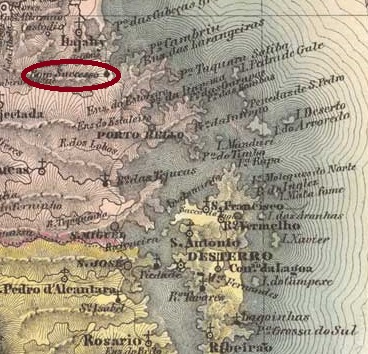
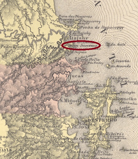
Villiers de l’Ile Adam: Carta (…) da Provincia de Santa Catharina, 1848
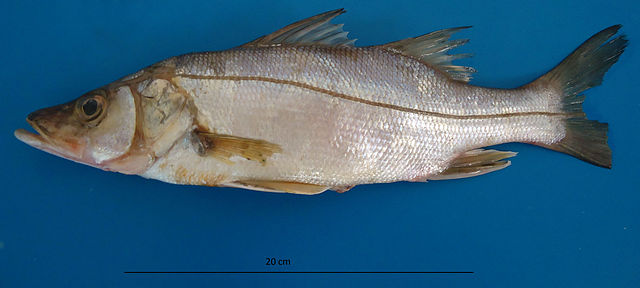
The Freguesia de N. Sra. do Bom Successo de Camboriú was founded in April 1849, belonged to the Vila de Itajahy (as it was written then) and was located on the south bank of the Camboriú, 90 km north of the provincial capital Desterro (today Florianópolis). It became a vila in its own município in April 1884. The indigenous word Camboriú means Robalos River. Robalo is the name of many South American sea bass of the family Centropomidae:
Centropomus parallelus (Poey, 1860, photo: Carla Isobel Elliff, CA BY 3.0)
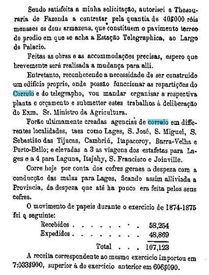
Reinhold Koester writes in Carimbologia VII that there had been a post office since September 1875. This is confirmed by the provincial president’s report of March 1876:
Relatorio do Presidente da Provincia, March 1876
The only imperial postmark so far is CSC-0035b, here according to R. Koester (op. cit.):
CSC-0035b (RK)Atlas do Imperio do Brasil, 1868
Die Freguesia de N. Sra. do Bom Successo de Camboriú wurde im April 1849 gegründet, gehörte zur Vila de Itajahy (wie man damals schrieb) und lag am Südufer des Camboriú, 90 km nördlich der Provinzhauptstadt Desterro (heute Florianópolis). Es wurde im April 1884 zu einer Vila im eigenen Município. Das indigene Wort Camboriú bedeutet Fluss der Robalos. Robalo ist der Name vieler südamerikanischer Wolfsbarsche aus der Familie Centropomidae:
Centropomus parallelus (Poey, 1860, Foto: Carla Isobel Elliff, CA BY 3.0)
Reinhold Koester schreibt in Carimbologia VII, dass es seit September 1875 ein Postamt gab. Dies wird durch den Bericht des Provinzpräsidenten vom März 1876 bestätigt:
Relatorio do Presidente da Provincia, März 1876
Der bisher einzige kaiserliche Poststempel ist CSC-0035b, hier nach R. Koester (op. cit.):
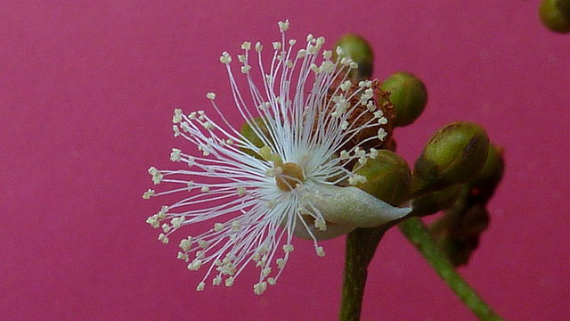
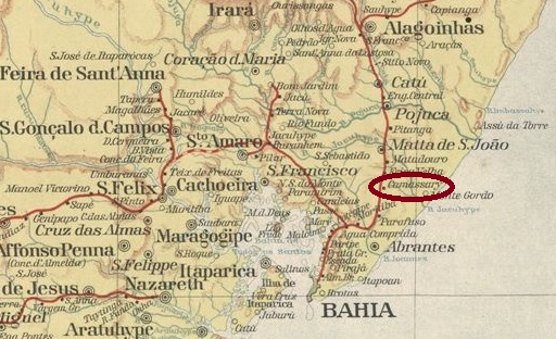
Inaugurated in September 1861 by the E.F. Bahia ao S. Francisco railway company, Camassary station is located on the banks of the river Camaçari (in the current spelling), 50 km north of the provincial capital Salvador da Bahia. The indigenous word Camaçari refers to a beautiful plant from the Callophyllaceae family:
Camaçari = Caraipa densifolia (Mart.). Photo: Alex Popovkin, Wikipedia Commons
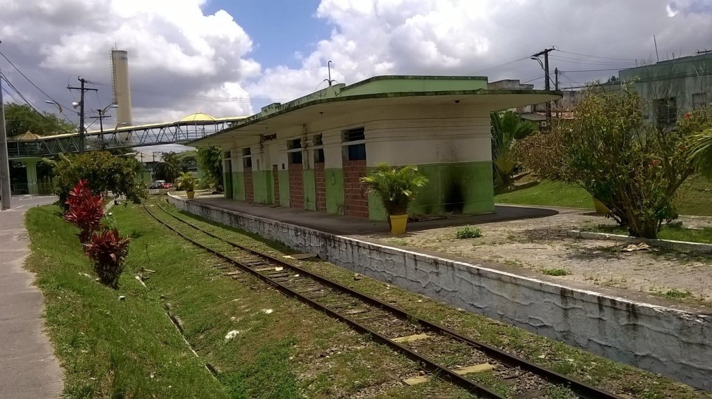
The railway line passed to the Cie Chemins de Fer Fédéraux de l’Est Brésilien in 1911, to the V.F.F. Leste Brasileiro in 1935, and belonged to Rede Ferroviária Federal S.A. (estacoesferroviarias.com.br) from 1975 until the line was closed in 1996. Today the tracks are still there, but the station is abandoned.
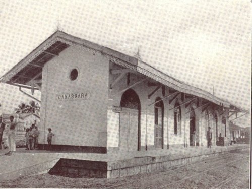
1923 (Ilustração Brasileira, on estacoesferroviarias.com.br)
2014 (Photo: Erivelto Souza, on estacoesferroviarias.com.br)
The area around the railway station belonged as a district to the Município Abrantes from August 1920, which became part of the newly created Município Montenegro in July 1925. Since March 1938, Camaçari has been an independent Município.
As the Rio press reported, there had been a post office at the railway station since April 1881:
Gazeta de Noticias/RJ, 21.04.1881
Reinhold Koester gives August 1881 for this in Carimbologia VII, which could perhaps be the date of the commissioning of this agency. So far, no imperial postmark from Camassary is known.
Estado da Bahia, 1913
Der Bahnhof Camassary wurde im September 1861 von der Eisenbahngesellschaft E.F. Bahia ao S. Francisco eingeweiht und liegt am Ufer des Flusses Camaçari (so die heutige Schreibweise), 50 km nördlich der Provinzhauptstadt Salvador da Bahia. Das indigene Wort Camaçari bezeichnet eine schöne Pflanze aus der Familie der Callophyllaceae:
Camaçari = Caraipa densifolia (Mart.). Foto: Alex Popovkin, Wikipedia Commons
Die Bahnlinie ging 1911 an die Cie Chemins de Fer Fédéraux de l’Est Brésilien, 1935 an die V.F.F. Leste Brasileiro über und gehörte von 1975 bis zur Stilllegung der Strecke 1996 der Rede Ferroviária Federal S.A. (estacoesferroviarias.com.br). Heute sind die Gleise noch vorhanden, aber der Bahnhof ist verlassen.
1923 (Ilustração Brasileira, auf estacoesferroviarias.com.br)2014 (Foto: Erivelto Souza, in estacoesferroviarias.com.br)
Das Gebiet um den Bahnhof gehörte ab August 1920 als Distrikt zum Município Abrantes, der im Juli 1925 in das neu gegründete Município Montenegro überging. Seit März 1938 ist Camaçari ein unabhängiges Município.
Wie die Presse von Rio berichtete, gab es seit April 1881 ein Postamt am Bahnhof:
Gazeta de Noticias/RJ, 21.04.1881
Reinhold Koester gibt dafür in Carimbologia VII den August 1881 an, was vielleicht der Beginn der Inbetriebnahme dieser Agentur sein könnte. Bisher ist kein kaiserlicher Poststempel aus Camassary bekannt.
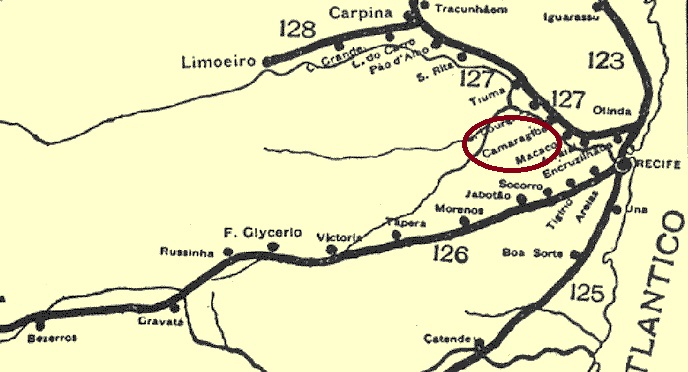
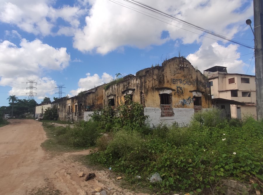
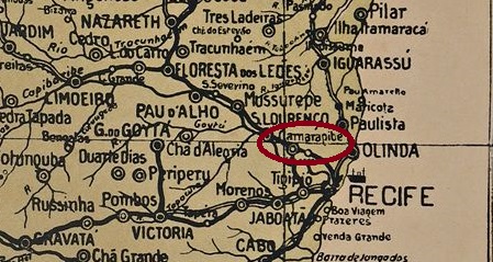
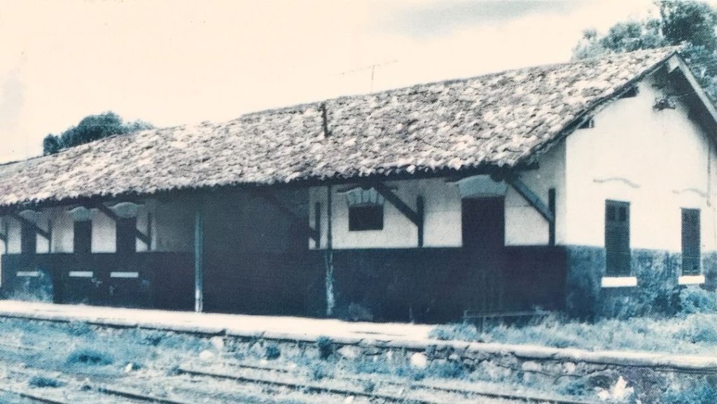
Camaragibe station was opened in October 1881 by the Great Western company (Northern Line) in the municipality of S. Lourenço da Mata, 15 km west of the provincial capital Recife. The railway line became the property of Rede Ferroviaria do Nordeste in 1950 and belonged to Rede Ferroviária Federal S.A. from 1975 until its closure in 1996 (estacoesferroviarias.com.br). Today the tracks are still there, the station building is an abandoned ruin.
Around 1920 (Fig. on estacoesferroviarias.com.br)2019 (Photo: Rodrigo Henrique on estacoesferroviarias.com.br)
The area around the station was annexed to the newly formed Município Camaragibe at the end of 1963. In July 1964 – i.e. shortly after the last military coup – this municipalisation was cancelled and not finally completed until May 1982. The indigenous word Camaragibe means river of the Camarás. Camará is a plant of the verbena family:
Lantana camara, L. (Photo: Alvesgaspar CC BY-SA 3.0)
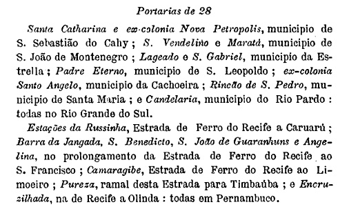
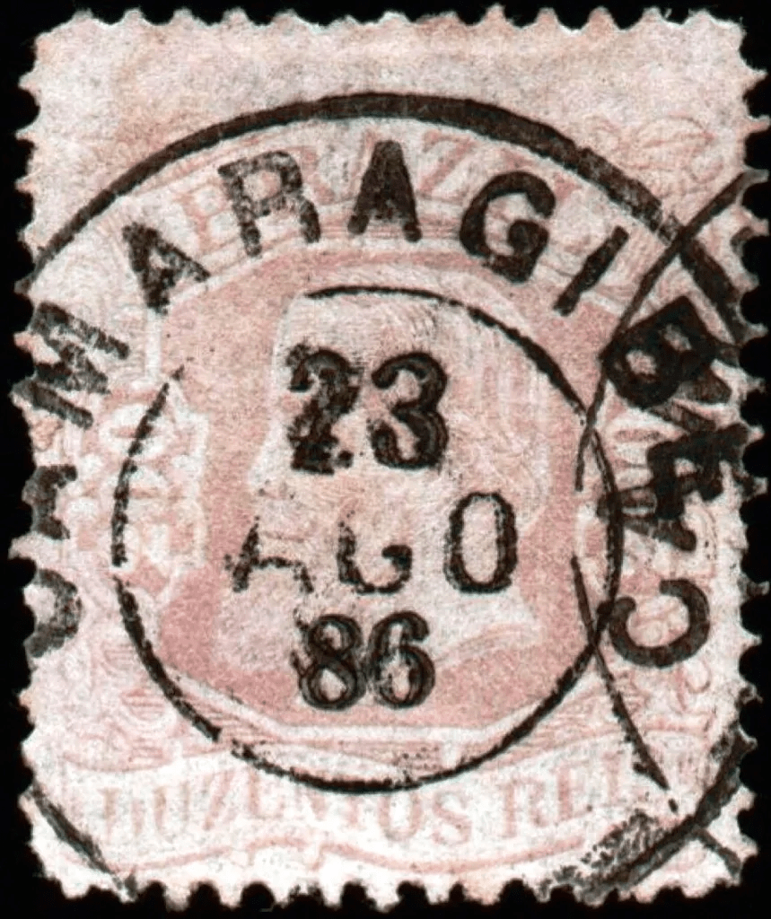
As R. Koester writes in Carimbologia VII, there was a post office at the station since October 1889, which is confirmed by the postal bulletin (Boletim Postal) of the following month:
Boletim Postal No. 7, November 1889
So far, no imperial postmark has been seen from this station, perhaps it does not even exist.
Arthur D. Ribeiro: Estado de Pernambuco, 1924
Der Bahnhof Camaragibe wurde im Oktober 1881 von der Gesellschaft Great Western (Nordlinie) eröffnet und lag in der Gemeinde S. Lourenço da Mata, 15 km westlich der Provinzhauptstadt Recife. Die Bahnlinie ging 1950 in den Besitz der Rede Ferroviária do Nordeste über und gehörte von 1975 bis zu ihrer Stilllegung 1996 der Rede Ferroviária Federal S.A. (estacoesferroviarias.com.br). Heute sind die Gleise noch vorhanden, das Bahnhofsgebäude ist eine verfallene Ruine.
Um 1920 (Abb. estacoesferroviarias.com.br)2019 (Foto: Rodrigo Henrique auf estacoesferroviarias.com.br)
Das Gebiet um den Bahnhof wurde Ende 1963 dem neu gegründeten Município Camaragibe zugeschlagen. Im Juli 1964 – also kurz nach dem letzten Militärputsch – wurde diese Gemeindegründung wieder aufgehoben und erst im Mai 1982 endgültig vollzogen. Das indigene Wort Camaragibe bedeutet Fluss der Camarás. Camará ist eine Pflanze aus der Familie der Eisenkrautgewächse:
Lantana camara, L. (Foto: Alvesgaspar CC BY-SA 3.0)
Wie R. Koester in Carimbologia VII schreibt, gab es am Bahnhof seit Oktober 1889 ein Postamt, was durch das Postbulletin (Boletim Postal) des folgenden Monats bestätigt wird:
Boletim Postal Nr. 7, November 1889
Bisher wurde kein kaiserlicher Poststempel von diesem Bahnhof gesehen, vielleicht gibt es ihn gar nicht.
Villiers de l’Ile Adam: Carta (…) das Provincias de Pernambuco, Alagoas e Sergipe, 1848
Another name: Passo do Camaragibe
A passo is a passable point of a river. The Freguesia de N. Sra. da Conceição do Passo de Camaragibe was founded in 1815, belonged to the Vila de Porto de Pedras and was situated on the west bank of the Camaragibe, about 80 km north of the later provincial capital Maceió. Three leguas – about 15 km – upstream was the village of Matriz de Camaragibe, where the main church was built, but where the Camaragibe River was unfortunately too deep for the trade route.
In June 1852 Passo de Camaragibe was declared a vila and in June 1880 a town. The place name changed to the short form Camaragibe in September 1912, but in March 1938 the old place name finally returned.
Three foundation years were found for the local post office. First in July 1839, as Aldo Cardoso writes in Contribuição para a História dos Correios de Alagoas (Maceió, 1969). Then in 1845, as indicated in the Directory of Imperial Post Offices (Tabella das Agencias do Correio do Imperio, Rio de Janeiro, 1885). And finally in January 1858, as stated in Administrações e Agencias Postaes do Brasil Imperio (Brasil Filatelico/RJ, 1934-5; Reprint SPP 1994-1999) by Nova Monteiro.
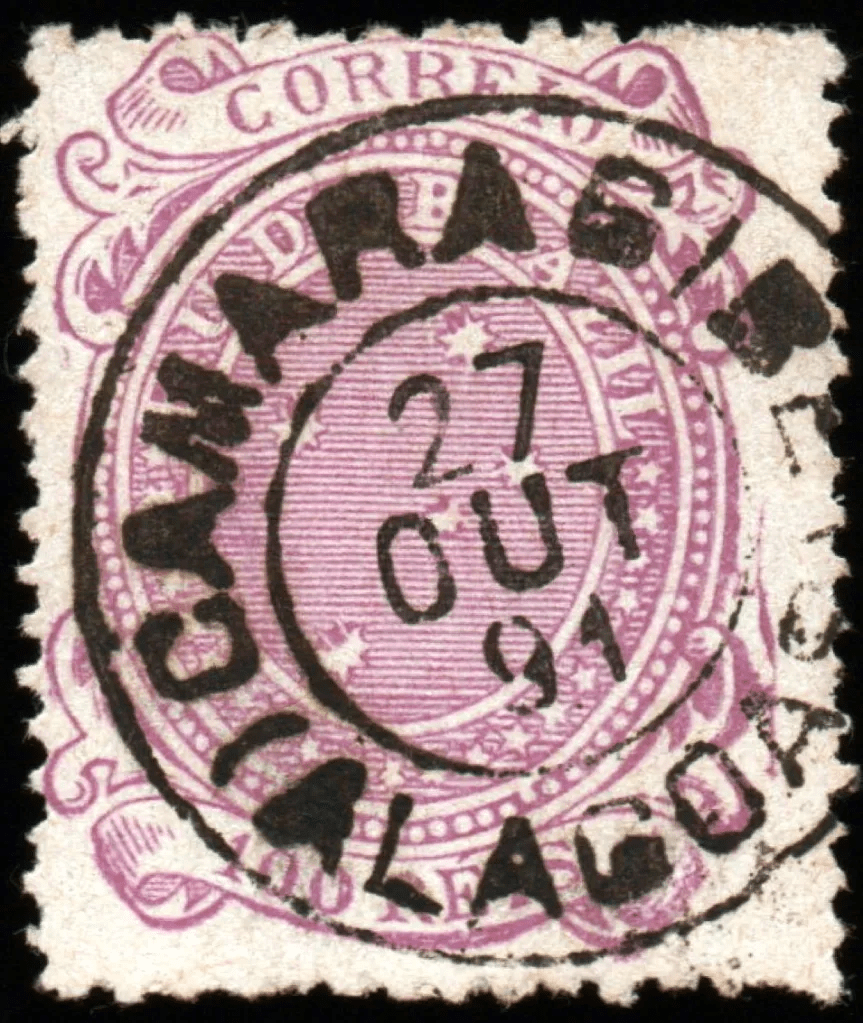
Reinhold Koester was unable to show an imperial postmark of Camaragibe in Carimbologia VII, instead, he had two Passo-cancels in Carimbologia XXX. Thanks to philatelist Claudio Coelho, here we have the first two Camaragibe cancels found for the 19th century:
CAL-0045b (CC) 1881ff-1891, also in blue.CAL-0045c (CC) 1891Atlas do Imperio do Brasil, 1868
Anderer Name: Passo do Camaragibe
Ein Passo ist eine passierbare Stelle eines Flusses. Die Freguesia de N. Sra. da Conceição do Passo de Camaragibe wurde 1815 gegründet, gehörte zur Vila de Porto de Pedras und lag am Westufer des Cmaragibe, knapp 80 km nördlich der späteren Provinzhauptstadt Maceió. Drei Léguas – also ca. 15 km – flussaufwärts lag der Ort Matriz de Camaragibe, wo zwar die Hauptkirche gebaut wurde, aber der Fluss Camaragibe leider zu tief für den Handelsweg war.
Im Juni 1852 wurde Passo de Camaragibe zur Vila und im Juni 1880 zur Stadt erklärt. Der Ortsname änderte sich im September 1912 in die Kurzform Camaragibe, aber im März 1938 kehrte der alte Ortsname endgültig zurück.
Für das örtliche Postamt wurden drei Gründungsjahre gefunden. Zuerst im Juli 1839, wie Aldo Cardoso in Contribuição para a História dos Correios de Alagoas (Maceió, 1969) schreibt. Dann 1845, wie im Verzeichnis der kaiserlichen Postämter (Tabella das Agencias do Correio do Imperio, Rio de Janeiro, 1885) angegeben. Und schließlich im Januar 1858, wie in Administrações e Agencias Postaes do Brasil Imperio (Brasil Filatelico/RJ, 1934-5; Reprint SPP 1994-1999) von Nova Monteiro nachzulesen ist.
Reinhold Koester konnte in Carimbologia VII keinen kaiserlichen Poststempel von Camaragibe zeigen, dafür hatte er zwei Passo-Stempel in Carimbologia XXX. Dank des Philatelisten Claudio Coelho haben wir hier die ersten beiden Camaragibe-Stempel, die für das 19. Jahrhundert gefunden wurden:
CAL-0045b (CC) 1881ff-1891, ebenfalls in blauCAL-0045c (CC) 1891
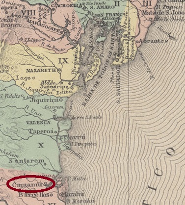
The aldeia (settlement) of N. Sra. de Assunção de Macamamú was founded as early as November 1561 on the north bank of the Orojó, 200 km south of the former colonial capital Salvador da Bahia. The place became a vila with the simplified name Camamú in May 1693 and was declared a town in June 1891.
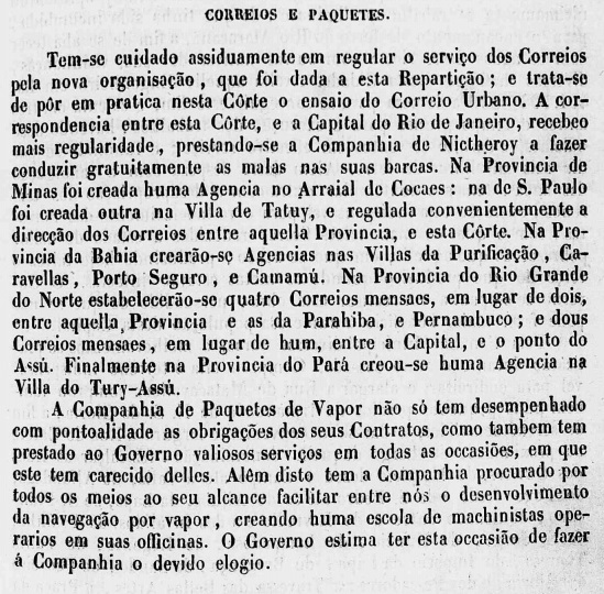
The report of the Imperial Ministry of May 1845 shows that there had been a post office in Camamú since April 1845:
Relatorio do Ministerio do Imperio, 05/1845
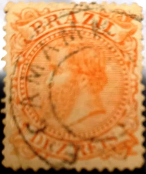
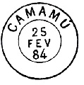
Two imperial postmarks were found, but unfortunately not the oldest one. On CBA-0210b (Coll. Fuad Ferreira Fo.) it says ..E CAMAMÚ. The letter E was often used at that time as an abbreviation for Estação (railway station). But since there was no railway line there, this E is probably the last letter of another word, e.g. for VILLA DE (CAMAMÚ):
CBA-0210b (FF) 1885ff
CBA-0210c is already known through Paulo Ayres in Catálogo de Carimbos Brasil-Império, (S. Paulo, 1937, 1942):
CBA-0210c (P.A. p.120) 1884-1885Villiers de l’Ile Adam: Carta (…) da Provincia da Bahia, 1848
Anderer Name: Macamamú
Die Aldeia (Siedlung) N. Sra. de Assunção de Macamamú wurde bereits im November 1561 am Nordufer des Orojó gegründet, 200 km südlich der ehemaligen Kolonialhauptstadt Salvador da Bahia. Der Ort wurde im Mai 1693 zur Vila mit dem vereinfachten Namen Camamú und im Juni 1891 zur Stadt erklärt.
Aus dem Bericht des Reichsministeriums vom Mai 1845 geht hervor, dass es in Camamú seit April 1845 ein Postamt gab:
Relatorio do Ministerio do Imperio, Mai 1845
Zwei kaiserliche Poststempel wurden gefunden, aber leider nicht der älteste. Auf CBA-0210b (Samml. Fuad Ferreira Fo.) steht ..E CAMAMÚ. Der Buchstabe E wurde damals oft als Abkürzung für Estação (Bahnhof) verwendet. Da dort aber keine Eisenbahnlinie verlief, ist dieses E wohl der letzte Buchstabe eines anderen Wortes, z.B. für VILLA DE (CAMAMÚ):
CBA-0210b (FF) 1885ff
CBA-0210c ist bereits bekannt durch Paulo Ayres in Catálogo de Carimbos Brasil-Império, (S. Paulo, 1937, 1942):
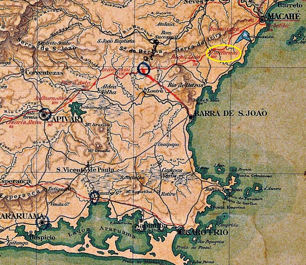
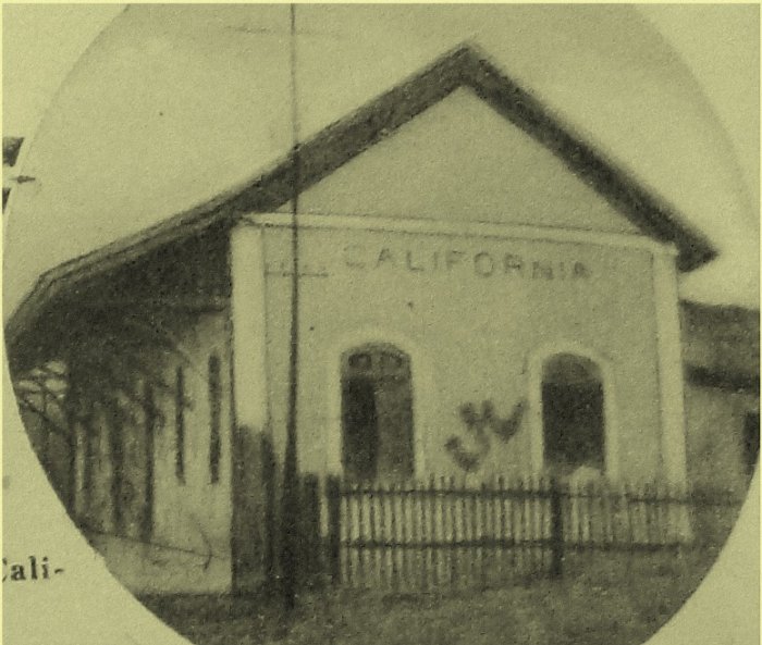
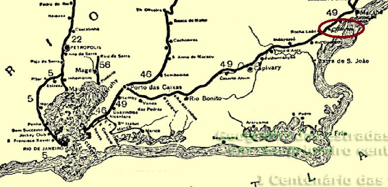
The California railway station was opened in November 1888 by the E.F. Leopoldina railway company and was located on the south bank of the Imboassica River in the Município Barra de S. João, 170 km northeast of the capital Rio de Janeiro. The area around the station belonged to the newly founded Município Casimiro de Abreu from March 1938 and has been in the Município Rio das Ostras since April 1992. The line belonged to Rede Ferroviária Federal S.A. (estacoesferroviarias.com.br) from 1975 until its closure the following year. Today the tracks are still there, the station building has already been demolished.
In 1923: Noite Ilustrada (in estacoesferroviarias.com.br)In 2012 (Foto: Bernardo Oberg in estacoesferroviarias.com.br)
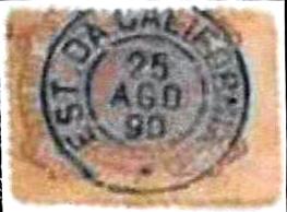
As Reinhold Koester writes in Carimbologia VIII, there was a post office at the station from January 1889. The oldest postmark is CRJ-0250a (Coll. Fuad Ferreira Fo.):
CRJ-0250a (FF) 1890
Koester (op. cit.) also shows us the seal cancel CRJ-0250b, without further details:
CRJ-0250b (RK)E. F. Leopoldina, 1898 (IBGE)
Der Bahnhof California wurde im November 1888 von der Eisenbahngesellschaft E.F. Leopoldina eröffnet und lag am Südufer des Flusses Imboassica im Município Barra de S. João, 170 km nordöstlich der Hauptstadt Rio de Janeiro. Das Gebiet um den Bahnhof gehörte ab März 1938 zum neu gegründeten Município Casimiro de Abreu und liegt seit April 1992 im Município Rio das Ostras. Die Strecke gehörte von 1975 bis zu ihrer Stilllegung im folgenden Jahr der Rede Ferroviária Federal S.A. (estacoesferroviarias.com.br). Heute sind die Gleise noch vorhanden, das Bahnhofsgebäude wurde bereits abgerissen.
1923: Noite Ilustrada (in estacoesferroviarias.com.br)2012 (Foto: Bernardo Oberg in estacoesferroviarias.com.br)
Wie Reinhold Koester in Carimbologia VIII schreibt, gab es ab Januar 1889 ein Postamt auf dem Bahnhof. Der älteste Poststempel ist CRJ-0250a (Samml. Fuad Ferreira Fo.):
CRJ-0250a (FF) 1890
Koester (op. cit.) zeigt uns auch den Siegelstempel CRJ-0250b, ohne weitere Details:
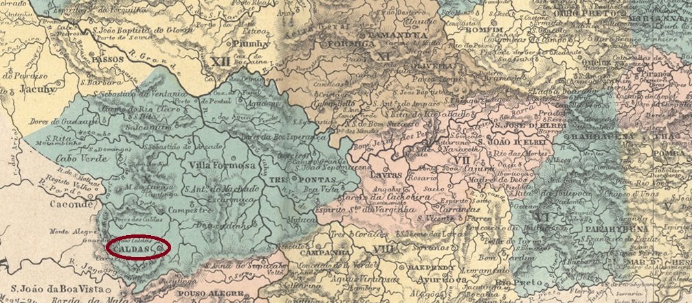
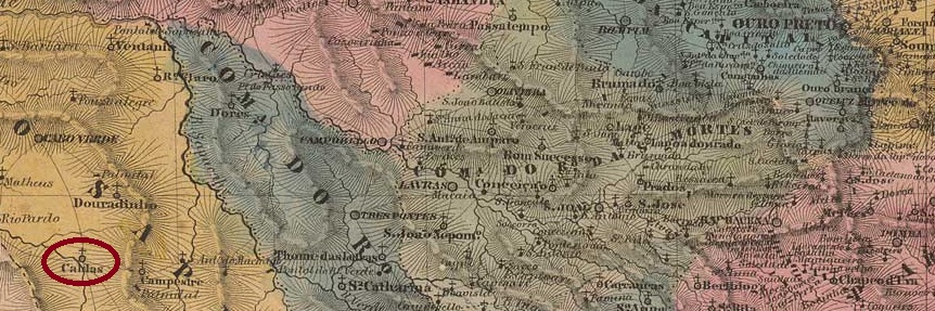
The freguesia of N. Sra. do Patrocínio do Rio Verde das Caldas was founded in March 1813, belonged to the Vila of Ouro Fino and was located on the east bank of the Rio Verde, 500 km southwest of the provincial capital of Ouro Preto. It was elevated to the status of vila in March 1839, belonged to the Município of Cabo Verde as a freguesia from March 1846 to October 1849, and became a town in June 1859. In December 1938, Caldas was renamed Parreiras (Vines), after the successful wine growing in the region. The new place name was probably not popular, because ten years later the old one returned.
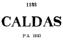
Reinhold Koester (Carimbologia VII) writes that there was a post office there from February 1845, but he had a copy of the June 1844 postmark CMG-0475a, which also appears in Paulo Ayres’ Catálogo de Carimbos Brasil-Império (S. Paulo, 1937, 1942) under no. 1133:
CMG-0475a (P.A. 1133) 1844-1857
The successor postmark is still unknown, as another postmark did not appear until 1880, as reported by R. Koester (op. cit.):
CMG-0475c (RK) 1880
Koester also mentions a similar cancel, CMG-0475d, which showed slightly larger letters than its predecessor.
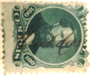
Possibly there was no postmark in Caldas from about 1857 onwards, as handwritten cancellations are found until after 1866:
1866ff (Coll. Paulo Corchaki)
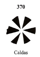
James Dingler and Klerman W. Lopes also show a mute cancellation from Caldas in Mute Cancellations of the Brazil Empire / Carimbos Mudos do Brasil Império (Brazil Philatelic Association, Rio de Janeiro, 2000), under no. 370:
BPA 370, 1866ff-1880Villiers de l’Ile Adam: Carta (…) da Provincia de Minas Geraes, 1849
Anderer Name: Parreiras (1938-1948)
Die Freguesia von N. Sra. do Patrocínio do Rio Verde das Caldas wurde im März 1813 gegründet, gehörte zur Vila von Ouro Fino und lag am Ostufer des Rio Verde, 500 km südwestlich der Provinzhauptstadt Ouro Preto. Der Ort wurde im März 1839 zur Vila erhoben, gehörte von März 1846 bis Oktober 1849 als Freguesia zum Município von Cabo Verde und wurde im Juni 1859 eine Stadt. Im Dezember 1938 wurde Caldas in Parreiras (Reben) umbenannt, nach dem erfolgreichen Weinanbau in der Region. Der neue Ortsname war wohl nicht unumstritten, denn zehn Jahre später kehrte der alte wieder zurück.
Reinhold Koester (Carimbologia VII) schreibt, dass es dort seit Februar 1845 ein Postamt gab, aber er besaß ein Exemplar des Poststempels CMG-0475a vom Juni 1844, der auch in Paulo Ayres’ Catálogo de Carimbos Brasil-Império, (S. Paulo, 1937, 1942) unter Nr. 1133 erscheint:
CMG-0475a (P.A. 1133) 1844-1857
Der Nachfolgestempel ist noch unbekannt, da erst 1880 ein weiterer Poststempel erschien, wie R. Koester (op. cit.) berichtet:
CMG-0475c (RK) 1880
Koester erwähnt auch einen ähnlichen Stempel, CMG-0475d, der etwas größere Buchstaben als sein Vorgänger zeigte.
Möglicherweise gab es in Caldas ab etwa 1857 keinen Poststempel mehr, da handschriftliche Entwertungen bis nach 1866 zu finden sind:
1866ff (Samml. Paulo Corchaki)
Aus Caldas zeigen auch James Dingler und Klerman W. Lopes in Mute Cancellations of the Brazil Empire / Carimbos Mudos do Brasil Império (Brazil Philatelic Association, Rio de Janeiro, 2000) eine stumme Entwertung unter Nr. 370:
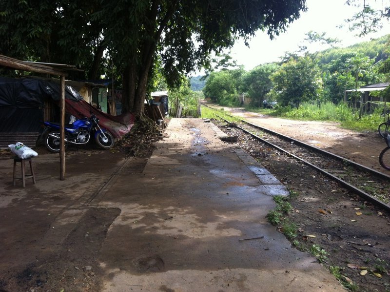
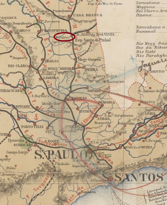
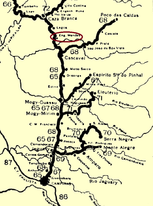
The Caldas (Thermes) railway station was opened in January 1878 by the Cia. Mogyana railway company (main line) and was in the Município S. João da Boa Vista, 200 km north of the provincial capital São Paulo. In 1886, the station was renamed after the Mogyana engineer Manoel da Silva Mendes, who died in June 1884. The area around the station belonged to the Cascavel district from August 1898 and has been in the Município Aguaí since November 1944. The railway line belonged to the FEPASA company from 1971 until its closure. Today, the tracks are still there, but the station building no longer exists.
According to the Directory of Imperial Post Offices (Tabella das Agencias do Correio do Imperio, Rio de Janeiro, 1885), there had been a post office at the station since 1882, and the regional press reported a postal agent in September of the same year:
Correio Paulistano, 27.09.1882
The first postmark, CSP-0450a, was already presented in R. Koester’s Carimbologia VII:
CSP-0450a (RK) 1884-1885
Its successor, CSP-0450b (Fig. Mário Celso Orsi Jr.), should already be Republican, as the only specimen so far is dated 1897:
CSP-0450b (MO) 1897
The presence of an imperial postmark Engenheiro Mendes is unlikely based on the dates found.
Cia. Mogyana, 1898 (IBGE)
Anderer Name: Engenheiro Mendes (1886)
Der Bahnhof Caldas (Thermen) wurde im Januar 1878 von der Eisenbahngesellschaft Cia. Mogyana (Hauptlinie) eröffnet und lag im Município S. João da Boa Vista, 200 km nördlich der Provinzhauptstadt São Paulo. 1886 wurde der Bahnhof nach dem im Juni 1884 verstorbenen Mogyana-Ingenieur Manoel da Silva Mendes umbenannt. Das Gebiet um den Bahnhof gehörte ab August 1898 zum Distrikt Cascavel und liegt seit November 1944 im Município Aguaí. Die Bahnlinie gehörte von 1971 bis zu ihrer Stilllegung der Gesellschaft FEPASA. Heute sind die Gleise noch vorhanden, das Bahnhofsgebäude existiert nicht mehr.
Wie aus dem Verzeichnis der kaiserlichen Postämter (Tabella das Agencias do Correio do Imperio, Rio de Janeiro, 1885) hervorgeht, gab es am Bahnhof seit 1882 ein Postamt, und die regionale Presse berichtete im September desselben Jahres von einem Postagenten:
Correio Paulistano, 27.09.1882
Der erste Poststempel, CSP-0450a, wurde bereits in R. Koesters Carimbologia VII vorgestellt:
CSP-0450a (RK) 1884-1885
Sein Nachfolger CSP-0450b (Abb. Mário Celso Orsi Jr.) dürfte bereits republikanisch sein, da das bisher einzige Exemplar 1897 datiert ist:
CSP-0450b (MO) 1897
Das Vorhandensein eines kaiserlichen Poststempels Engenheiro Mendes ist aufgrund der gefundenen Daten unwahrscheinlich.
Instituto Brasileiro de Geografia e Estatística, 1898
Another name: Calçada do Bomfim
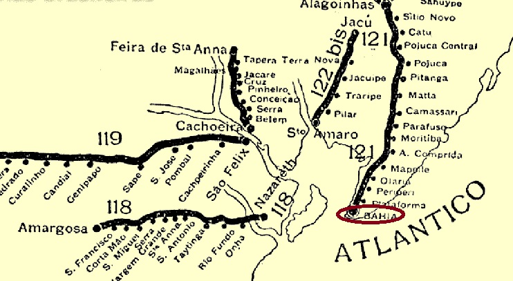
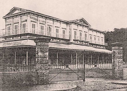
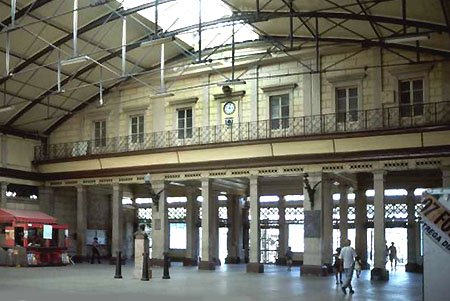
Calçada station was opened in June 1860 as the terminus of the E.F. Bahia ao S. Francisco railway company and was in the Bomfim district of Salvador da Bahia. The railway line passed to the Cie. Chemins de Fer Fédéraux de l’Est Brésilien in 1911, to the Viação Férrea F. Leste Brasileiro in 1935, to the Rede Ferroviária Federal S.A. in 1975 and has been operated since 1996 by the Cia. Brasileira de Transportes Urbanos (estacoesferroviarias.com.br). The station building was rebuilt in 1936.
1861 (Photo: Flavio Cavalcanti, on estacoesferroviarias.com.br)2002 (Photo: Alexandre Santurion, on estacoesferroviarias.com.br)
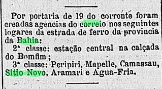
As the Rio press wrote, there had been a post office there since April 1881:
Gazeta de Noticias/RJ, 21.04.1881
Reinhold Koester gives August 1881 for this in Carimbologia VII, which could be the date this agency was put into operation.
The only 19th century postmark so far is CBA-0205a (image from the internet): a double circle with the inscriptions CALÇADA above and (BAHIA) below. One copy was seen, dated 1893 in the centre.
Guia Quatro Rodas (in estacoesferroviarias.com.br)
Anderer Name: Calçada do Bomfim
Der Bahnhof Calçada wurde im Juni 1860 als Endstation der Eisenbahngesellschaft E.F. Bahia ao S. Francisco eröffnet und lag im Stadtteil Bomfim von Salvador da Bahia. Die Bahnlinie ging 1911 an die Cie. Chemins de Fer Fédéraux de l’Est Brésilien, 1935 an die Viação Férrea F. Leste Brasileiro, 1975 an die Rede Ferroviária Federal S.A. über und wird seit 1996 von der Cia. Brasileira de Transportes Urbanos (estacoesferroviarias.com.br) betrieben. Das Bahnhofsgebäude wurde 1936 umgebaut.
1861 (Foto: Flavio Cavalcanti, auf estacoesferroviarias.com.br)2002 (Foto: Alexandre Santurion, auf estacoesferroviarias.com.br)
Wie die Presse von Rio schrieb, gab es dort seit April 1881 ein Postamt:
Gazeta de Noticias/RJ, 21.04.1881
Reinhold Koester gibt in Carimbologia VII dafür den August 1881 an, was das Datum der Inbetriebnahme dieser Agentur sein könnte.
Der bisher einzige Poststempel aus dem 19. Jahrhundert ist CBA-0205a (Abbildung aus dem Internet): ein Doppelkreis mit den Inschriften CALÇADA oben und (BAHIA) unten. Ein Exemplar gesehen, datiert 1893 in der Mitte.
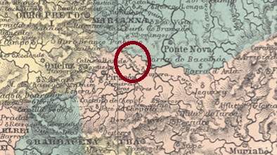
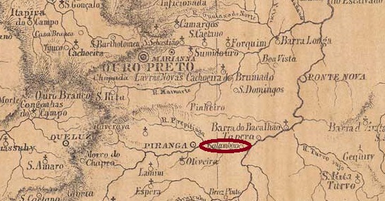
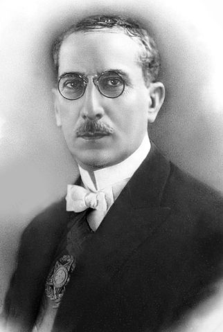
The chapel of Sto. Antonio do Calambao was built in August 1755 on the north bank of the Piranga River, 90 km southeast of the future provincial capital of Ouro Preto. In July 1868, it became a parish of the Vila de Mariana and in December 1874, it went to the Município Piranga as a freguesia. Its elevation to an independent município was accompanied by its renaming as Presidente Bernardes in December 1953. The Indian word Calambao means clearing in the woods. Arthur Bernardes (1875-1955), a Mineiro, was President of Brazil from 1922 to 1926.
Arthur Bernardes (Wikipedia)
Two creation dates have been found for the local post office. The first in 1880, as given in the Directory of Imperial Post Offices (Tabella das Agencias do Correio do Imperio, Rio de Janeiro, 1885). Then again in September 1883, as Paula Sobrinho writes in História Postal de Minas Gerais (Belo Horizonte, 1997). The oldest postmark so far is CMG-0470a (image from the Internet): a double circle with the inscription CALAMBAO above and a leaf ornament below. Two copies were seen, dated between 1894 and 1903 in the centre.
Provincia de Minas Geraes, 1873
Textaktualisierung vom 14. August 2023
Anderer Name: Presidente Bernardes (1953)
Die Kapelle von Sto. Antonio do Calambao wurde im August 1755 am Nordufer des Flusses Piranga, 90 km südöstlich der späteren Provinzhauptstadt Ouro Preto, errichtet. Im Juli 1868 wurde sie zur Pfarrei der Vila von Mariana und ging im Dezember 1874 als Freguesia zum Município Piranga. Mit der Erhebung zum eigenständigen Município ging im Dezember 1953 die Umbenennung in Presidente Bernardes einher. Das indianische Wort Calambao bedeutet Waldlichtung. Arthur Bernardes (1875-1955), ein gebürtiger Mineiro, war von 1922 bis 1926 Präsident Brasiliens.
Arthur Bernardes (Wikipedia)
Für das örtliche Postamt wurden zwei Gründungsdaten gefunden. Das erste im Jahr 1880, wie im Verzeichnis der kaiserlichen Postämter (Tabella das Agencias do Correio do Imperio, Rio de Janeiro, 1885) angegeben. Dann wieder im September 1883, wie Paula Sobrinho in História Postal de Minas Gerais (Belo Horizonte, 1997) schreibt. Der bisher älteste Poststempel ist CMG-0470a (Abbildung aus dem Internet): ein Doppelkreis mit der Inschrift CALAMBAO oben und einem Blattornament unten. Ein Exemplar gesehen, datiert 1903 in der Mitte.