Categories
Carimbologia C-D

Capituba, Minas Gerais (CMG-0590)

Atlas do Imperio do Brasil, 1868

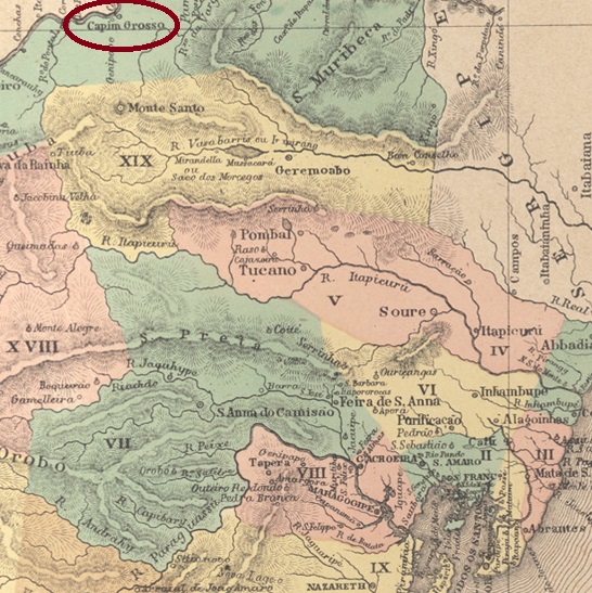
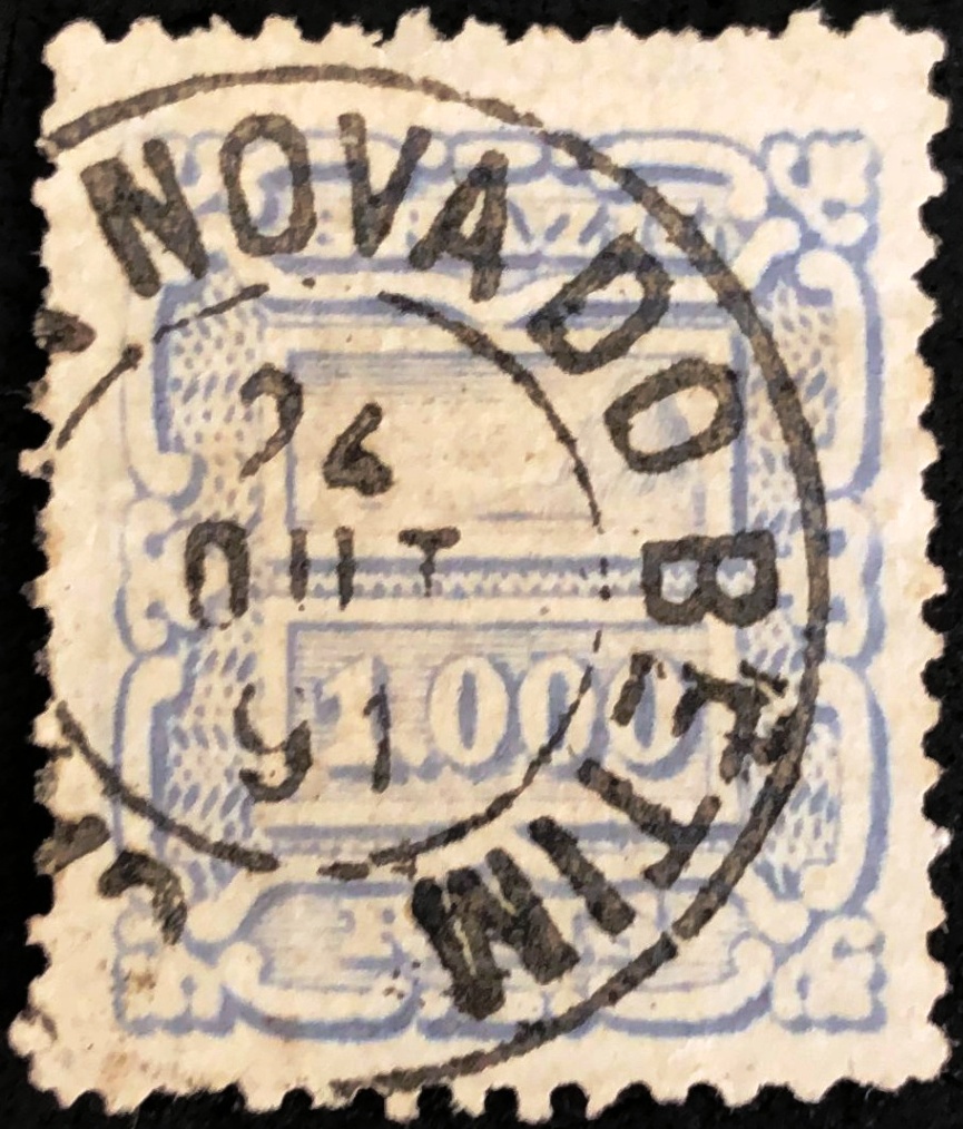
Other names: Pedra Branca, Pedralva (1943)

See also São Sebastião da Pedra Branca (SMG-2595)

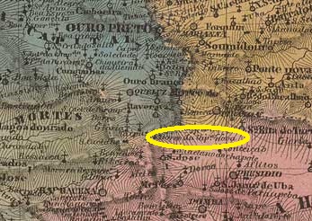
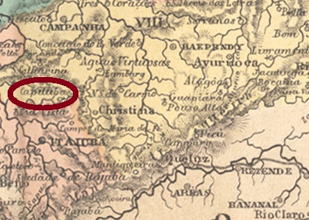
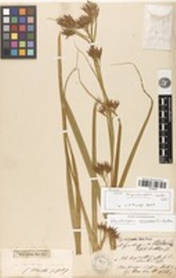
São Sebastião do Capituba was a freguesia of Christina from July 1832, situated 400 km southwest of the provincial capital Ouro Preto. Capituba is the name given in Brazil to an aquatic plant (Rynchospora aurea) of the Cyperaceae family:

Rynchospora aurea (plants.jstor.org)

In November 1880, the place rose to the status of a district under the name of São Sebastião da Pedra Branca (= of the white stone), which was elevated to the status of a villa in October 1884. After that, the place name changed twice: in September 1891 to Pedra Branca and in December 1943 to Pedralva.

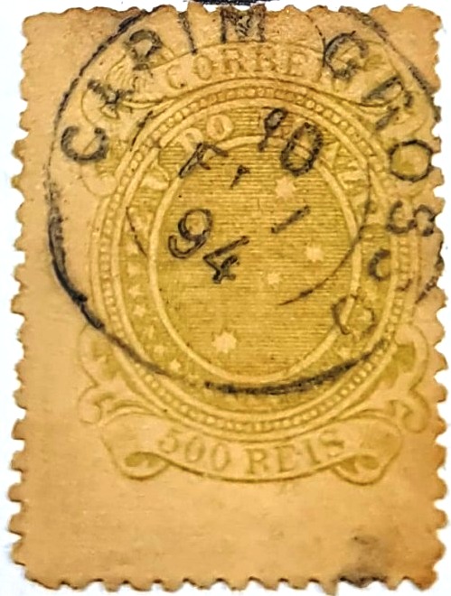
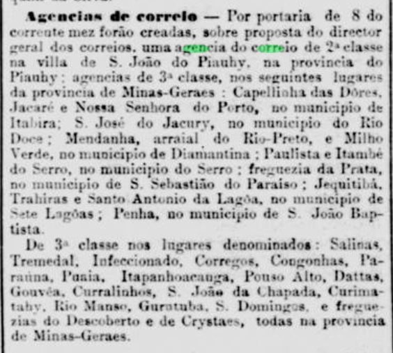
Paula Sobrinho writes in História Postal de Minas Gerais (Belo Horizonte, 1997) that the local post office was created in October 1877. However, it did not start operating until April of the following year, as noticed by the Rio press:

Gazeta de Noticias/RJ, 20/03/1878

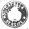
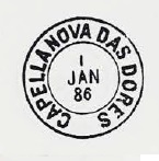
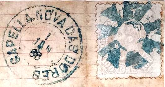
The oldest postmark from there is CMG-0590a, which also occurs in red and was shown by R. Koester in Carimbologia IX:

CMG-0590a (RK) 1886-1887
Villiers de l’Ile Adam: Carta (…) da Provincia de Minas Geraes, 1849

Andere Namen: Pedra Branca, Pedralva (1943)

Siehe auch São Sebastião da Pedra Branca (SMG-2595)

São Sebastião do Capituba war ab Juli 1832 eine Freguesia von Christina, die 400 km südwestlich der Provinzhauptstadt Ouro Preto entfernt lag. Capituba nennt man in Brasilien eine Wasserpflanze (Rynchospora aurea) der Familie Cyperaceae:

Rynchospora aurea (plants.jstor.org)

Im November 1880 stieg der Ort zum Distrikt unter dem Namen São Sebastião da Pedra Branca (= vom weißen Stein), der im Oktober 1884 zur Villa erhoben wurde. Danach wechselte der Ortsname zweimal: im September 1891 zu Pedra Branca und im Dezember 1943 zu Pedralva.

Paula Sobrinho schreibt in História Postal de Minas Gerais (Belo Horizonte, 1997), dass das örtliche Postamt im Oktober 1877 entstanden ist. Allerdings wurde der Betrieb erst im April des folgenden Jahres aufgenommen, wie die Presse aus Rio informiert:

Gazeta de Noticias/RJ, 20.03.1878

Der älteste Poststempel von dort ist CMG-0590a, der auch in Rot vorkommt und von R. Koester in Carimbologia IX gezeigt wurde:

CMG-0590a (RK) 1886-1887
Categories
Carimbologia C-D

Capitão Mor, São Paulo (CSP-0300)

agenciaspostais.com.br

Other names: Alambary, Arapeí (1944)

With Capitão-Mor we have another place that is hardly to be found on maps under this name: around 1873 it was a rural district of Vila Bananal on the Caminho Novo in the direction of S. José do Barreiro, 300 km northeast of the provincial capital S. Paulo and did not even have a church. This was in the neighbouring Curato de Alambary. Capitão Mor and Alambary were also the names of two streams that flowed parallel to the north and joined in Alambary.

Capitão-Mor as a place disappeared around 1890. It is likely that it was absorbed into Alambary. This in turn was not the freguesia of Itapetininga (see ASP-0010), but became the district of Bananal in May 1891, changed its name to Arapeí in November 1944 and has been an independent município since December 1991.

According to the Rio press, there has been a post office there since December 1864:

Jornal do Commercio/RJ, 14.12.1864

Two postmarks have survived from the imperial period. CSP-0300b was shown by R. Koester in Carimbologia IX.

CSP-0300b (RK) 1882-1887

Its successor CSP-0300c (fig. Felipe Piccinini) is a French type:

CSP-0300c (FP) 1889-1897

As seen, the late dates possibly indicate that the cancel remained after the place name has disappeared. Perhaps the cancel was used later in Alambary?

Google Maps

Andere Namen: Alambary, Arapeí (1944)

Mit Capitão-Mor haben wir einen weiteren Ort, der unter diesem Namen kaum auf Karten zu finden ist: Es war um 1873 ein ländlicher Ortsteil von Vila Bananal auf dem Caminho Novo in Richtung S. José do Barreiro, 300 km nordöstlich der Provinzhauptstadt S. Paulo gelegen und hatte nicht einmal eine Kirche. Diese befand sich im benachbarten Curato de Alambary. Capitão Mor und Alambary waren auch die Namen zweier Bäche, die parallel nach Norden flossen und sich in Alambary vereinigten.

Capitão-Mor als Ort verschwand um 1890. Es ist anzunehmen, dass es in Alambary aufgegangen ist. Dieser wiederum war nicht die Freguesia von Itapetininga (siehe ASP-0010), sondern wurde im Mai 1891 zum Distrikt von Bananal, änderte seinen Namen in Arapeí im November 1944 und ist seit Dezember 1991 ein eigenständiges Município.

Wie der Presse von Rio zu entnehmen ist, gibt es dort seit Dezember 1864 ein Postamt:

Jornal do Commercio/RJ 14.12.1864

Aus der Kaiserzeit sind zwei Poststempel erhalten. CSP-0300b wurde von R. Koester in Carimbologia IX veröffentlicht.

CSP-0300b (RK) 1882-1887

Sein Nachfolger CSP-0300c (Abb. Felipe Piccinini) ist ein französischer Typ:

CSP-0300c (FP) 1889-1897

Wie man sieht, deuten die späten Daten möglicherweise darauf hin, dass der Stempel den Ortsnamen überlebt hat. Vielleicht wurde der Stempel später in Alambary verwendet?

Categories
Carimbologia C-D

Capim Grosso, Bahia (CBA-0245)

Atlas do Imperio do Brasil, 1868

Text updated on August 10, 2024

Other names: Pambu, Bom Jesus da Boa Morte, Curaçá (1890)

Here we have another place with a complicated history, as it has been moved and renamed. As early as 1714 there was a Freguesia de Sto. Antonio do Pambu on the south bank of S. Francisco, which belonged to the Vila de Joazeiro and was itself elevated to a Vila in June 1832. However, this was transferred to the former Freguesia de Bom Jesus da Boa Morte (Good Jesus of the Blessed Death) in June 1853 and was named Vila de Capim Grosso. It was still located on the São Francisco, 550 km northwest of the provincial capital Salvador da Bahia, and was elevated to a town in August 1890, now under the place name Curaçá.

Nova Monteiro writes in Administrações e Agencias Postaes do Brasil Imperio (Brasil Filatelico/RJ, 1934-5; Reprint SPP 1994-1999) that there was a post office there since September 1866. R. Koester gives a date for this in Carimbologia IX that is exactly one year earlier, which could be a printing or reading error. The oldest postmark from Capim Grosso to date is CBA-0245b (fig. Felipe Piccinini):

CBA-0245b (FP) 1894
Villiers de l’Ile Adam: Carta (…) da Provincia da Bahia, 1848

Textaktualisierung am 10. August 2024

Andere Namen: Pambu, Bom Jesus da Boa Morte, Curaçá (1890)

Hier haben wir wieder einen Ort mit komplizierter Geschichte, da er verlegt und umbenannt wurde. Bereits 1714 gab es eine Freguesia de Sto. Antonio do Pambu am Südufer des S. Francisco, die zur Vila de Joazeiro gehörte und im Juni 1832 selbst zur Vila erhoben wurde. Diese wurde jedoch im Juni 1853 in die ehemalige Freguesia de Bom Jesus da Boa Morte (Guter Jesus vom Seligen Tod) verlegt und erhielt den Namen Vila de Capim Grosso. Sie lag immer noch am São Francisco, 550 km nordwestlich der Provinzhauptstadt Salvador da Bahia, und wurde im August 1890 zur Stadt erhoben, nun unter dem Ortsnamen Curaçá.

Nova Monteiro schreibt in Administrações e Agencias Postaes do Brasil Imperio (Brasil Filatelico/RJ, 1934-5; Reprint SPP 1994-1999), dass es dort seit September 1866 ein Postamt gab. R. Koester gibt dafür ein Datum in Carimbologia IX an, das genau ein Jahr früher liegt, was ein Druck- oder Lesefehler sein könnte. Der bisher älteste Poststempel aus Capim Grosso ist CBA-0245b (Abb. Felipe Piccinini):

CBA-0245b (FP) 1894
Categories
Carimbologia C-D

Capim Branco, Minas Gerais (CMG-0585)

Atlas do Imperio do Brasil, 1868

Other names: Rio Preto, Unaí (1923)

This locality is not the present municipality of Capim Branco; this was a freguesia of the Vila Santa Luzia and a district of Matozinhos. Our freguesia of Capim Branco was founded in June 1859, belonged to the Vila de Paracatu and was located on the south bank of the Rio Preto, 850 km northwest of the provincial capital Ouro Preto. In November 1873, the place name was changed to Rio Preto and in September 1923 to Unaí. The indigenous term means black water (thus: Rio Preto). Unaí has been an independent municipality since December 1943.

Paula Sobrinho (História Postal de Minas Gerais, Belo Horizonte, 1997) and R. Koester (Carimbologia IX) write that there was a post office there since April 1884, which is confirmed by the Rio press:

Gazeta de Noticias/RJ, 20.04.1884

Although the place was called Rio Preto since 1873, Capim Branco is known as a post office until at least 1894. An imperial postmark from there has not been seen so far.

Carta da Republica dos Estados Unidos do Brazil, 1892

Andere Namen: Rio Preto, Unaí (1923)

Diese Ortschaft ist nicht die heutige Gemeinde Capim Branco; diese war eine Freguesia der Vila Santa Luzia und ein Distrikt von Matozinhos. Die Freguesia von Capim Branco wurde im Juni 1859 gegründet, gehörte zur Vila de Paracatu und lag am Südufer des Rio Preto, 850 km nordwestlich der Provinzhauptstadt Ouro Preto. Im November 1873 wurde der Ortsname in Rio Preto und im September 1923 in Unaí geändert. Der indigene Begriff bedeutet schwarzes Wasser (also: Rio Preto). Seit Dezember 1943 ist Unaí ein eigenständiger Município.

Paula Sobrinho (História Postal de Minas Gerais, Belo Horizonte, 1997) und R. Koester (Carimbologia IX) schreiben, dass es dort seit April 1884 ein Postamt gab, was von der Presse in Rio bestätigt wird:

Gazeta de Noticias/RJ, 20.04.1884

Obwohl der Ort seit 1873 Rio Preto hieß, ist Capim Branco als Postamt bis mindestens 1894 bekannt. Ein kaiserlicher Poststempel von dort wurde bisher nicht gesehen.

Categories
Carimbologia C-D

Capellinha, Minas Gerais (CMG-0555)

Atlas do Imperio do Brasil, 1868

Other names: Graça, Capellinha da Graça

Capellinha de N. Sra. da Graça was a freguesia of the Vila de Minas Novas on the south bank of the Córrego Areão, 480 km north of the provincial capital Ouro Preto, since June 1858. Since August 1911, the place has been Município de Capelinha.

Three philatelists write that on 10 August 1862 it was decided to establish a post office there: Nova Monteiro in Administrações e Agencias Postaes do Brasil Imperio (Brasil Filatelico/RJ, 1934-5; reprint SPP 1994-1999), R. Koester in Carimbologia IX and Paula Sobrinho in História Postal de Minas Gerais (Belo Horizonte, 1997). However, two other sources give a date 20 days later: the postal report (Relatorio dos Correios) for 1886 and the Rio press:

Diario do Rio de Janeiro, 26.09.1862

A postmark for the Empire was found. CMG-0555b (Coll. Fuad Ferreira Fo.), which also exists in blue, presents dates from 1879 to 1896:

CMG-0555b (FF) 1879-1896

James Dingler and Klerman W. Lopes have illustrated three mute cancellations from Capellinha in Mute Cancellations of the Brazil Empire / Carimbos Mudos do Brasil Império (Brazil Philatelic Association, Rio de Janeiro, 2000):

BPA 1104 – 1105 – 1107 (1879)
Villiers de l’Ile Adam: Carta (…) da Provincia de Minas Geraes, 1849

Andere Namen: Graça, Capellinha da Graça

Capellinha de N. Sra. da Graça war seit Juni 1858 eine Freguesia der Vila de Minas Novas am Südufer des Córrego Areão, 480 km nördlich der Provinzhauptstadt Ouro Preto. Seit August 1911 ist der Ort der Município de Capelinha.

Drei Philatelisten schreiben, dass am 10. August 1862 beschlossen wurde, dort ein Postamt einzurichten: Nova Monteiro in Administrações e Agencias Postaes do Brasil Imperio (Brasil Filatelico/RJ, 1934-5; Reprint SPP 1994-1999), R. Koester in Carimbologia IX und Paula Sobrinho in História Postal de Minas Gerais (Belo Horizonte, 1997). Allerdings geben zwei andere Quellen ein um 20 Tage späteres Datum an: der Postbericht (Relatorio dos Correios) von 1886 und die Presse aus Rio:

Diario do Rio de Janeiro, 26.09.1862

Ein Poststempel für das Kaiserreich wurde gefunden. CMG-0555b (Samml. Fuad Ferreira Fo.), den es auch in blau gibt, hat Daten von 1879 bis 1896:

CMG-0555b (FF) 1879-1896

James Dingler und Klerman W. Lopes haben drei stumme Abstempelungen aus Capellinha in Mute Cancellations of the Brazil Empire / Carimbos Mudos do Brasil Império (Brazil Philatelic Association, Rio de Janeiro, 2000) abgebildet:

BPA 1104 – 1105 – 1107 (1879)
Categories
Carimbologia C-D

Capellinha das Dores, Minas Gerais (CMG-0565)

Estado de Minas Geraes, 1910

See also Dores de Guanhães (DMG-1040)

The locality of Capellinha das Dores became a district in April 1854, belonged to the Vila of Conceição do Mato Dentro and was located on the south bank of the Guanhães, 260 km north of the provincial capital of Ouro Preto. In September 1870, it was elevated to a freguesia and assigned to the Vila of S. Miguel de Guanhães under the name N. Sra. das Dores. In September 1923, the place name was simplified to Dores de Guanhães, which has been an independent município since December 1962.

Of the three creation dates for the local post office, one is probably wrong, the other two possibly belong together. In the Directory of Imperial Post Offices (Tabella das Agencias do Correio do Imperio, Rio de Janeiro, 1885) the year 1862 is given, but this is more likely a case of confusion with the other Capellinha in Minas Gerais (CMG-0555), where a post office was founded in that year. Both Paula Sobrinho in História Postal de Minas Gerais (Belo Horizonte, 1997) and R. Koester in Carimbologia IX write a creation date for February 1881, while the Rio press reports a new post office in Capellinha das Dores in November of the same year:

Jornal do Commercio/RJ, 12.11.1881

No imperial postmark with this place name has yet been found. For postmarks with DORES DE GUANHÃES see DMG-1040.

Google Maps

Siehe auch Dores de Guanhães (DMG-1040)

Die Siedlung Capellinha das Dores wurde ein Distrikt im April 1854, gehörte zur Vila von Conceição do Mato Dentro und lag am Südufer des Guanhães, 260 km nördlich der Provinzhauptstadt Ouro Preto. Im September 1870 wurde es zur Freguesia erhoben und unter dem Namen N. Sra. das Dores der Vila von S. Miguel de Guanhães zugeordnet. Im September 1923 wurde der Ortsname in Dores de Guanhães vereinfacht, der Ort ist seit Dezember 1962 ein eigenständiges Município.

Von den drei gefundenen Gründungsdaten für das örtliche Postamt dürfte eines falsch sein, die beiden anderen gehören möglicherweise zusammen. Im Verzeichnis der kaiserlichen Postämter (Tabella das Agencias do Correio do Imperio, Rio de Janeiro, 1885) wird das Jahr 1862 angegeben, aber hier liegt eher eine Verwechslung mit dem anderen Capellinha in Minas Gerais (CMG-0555) vor, wo in diesem Jahr ein Postamt gegründet wurde. Paula Sobrinho in História Postal de Minas Gerais (Belo Horizonte, 1997) und R. Koester in Carimbologia IX schreiben den Februar 1881 fürs Postamt, während die Presse in Rio im November desselben Jahres von einem neuen Postamt in Capellinha das Dores berichtet:

Jornal do Commercio/RJ 12.11.1881

Bisher wurde noch kein kaiserlicher Poststempel mit diesem Ortsnamen gefunden. Für Stempel mit DORES DE GUANHÃES siehe DMG-1040.

Categories
Carimbologia C-D

Capella, Sergipe (CSE-0045)

Villiers de l’Ile Adam: Carta (…) das Provincias de Pernambuco, Alagoas e Sergipe, 1848

Text update of February 26, 2025

The Freguesia de N. Sra. da Purificação da Capella was founded in February 1813 by royal decree (Alvará Real), belonged to the Vila de Sto. Amaro das Brotas and was located 70 km north of the later provincial capital of Aracaju. It became a vila in February 1835 and a town in August 1888.

Two dates have been handed down for the creation of the local post office. Once in December 1844, as shown in Nova Monteiro’s Administrações e Agencias Postaes do Brasil Imperio (Brasil Filatelico/RJ, 1934-5; reprint SPP 1994-1999). Then again in 1849, as shown in the Directory of Imperial Post Offices (Tabella das Agencias do Correio do Imperio, Rio de Janeiro, 1885). From the first period, the cancel CSE-0045a is known, listed by Paulo Ayres (Catálogo de Carimbos Brasil-Império, S. Paulo, 1937, 1942) as No. 1259 and appearing on the 1843 and 1844 stamp issues:

CSE-0045a (P.A. 1259) 1843.1844ff

It was followed by CSE-0045b, illustrated in Carimbologia IX by R. Koester:

CSE-0045b (RK)

Koester also showed the seal cancel CSE-0045c:

CSE-0045c (RK)

Thanks to the philatelist Claudio Coelho we were able to confirm that the following postmark CSE-0045d (fig. R. Koester in Carimbologia I) also comes from Capella/SE:

CSE-0045d (RK) 1880-1885

Towards the end of the century also CSE-0045e appeared (image from the internet):

CSE-0045e (EB) 1889-1900
Atlas do Imperio do Brasil, 1868

Textaktualisierung am 26. Februar 2025

Die Freguesia de N. Sra. da Purificação da Capella wurde im Februar 1813 durch königliches Dekret (Alvará Real) gegründet, sie gehörte zur Vila de Sto. Amaro das Brotas und lag 70 km nördlich der späteren Provinzhauptstadt Aracaju. Im Februar 1835 wurde sie zur Vila und im August 1888 zur Stadt erhoben.

Für die Gründung des örtlichen Postamtes sind zwei Daten überliefert. Einmal im Dezember 1844, wie aus Nova Monteiros Administrações e Agencias Postaes do Brasil Imperio (Brasil Filatelico/RJ, 1934-5; Nachdruck SPP 1994-1999) hervorgeht. Dann wieder 1849, wie aus dem Verzeichnis der kaiserlichen Postämter (Tabella das Agencias do Correio do Imperio, Rio de Janeiro, 1885) hervorgeht. Aus der ersten Periode ist der Stempel CSE-0045a bekannt, der von Paulo Ayres (Catálogo de Carimbos Brasil-Império, S. Paulo, 1937, 1942) mit der Nr. 1259 aufgeführt wird und auf den Markenausgaben von 1843 und 1844 erscheint:

CSE-0045a (P.A. 1259) 1843-1844ff

Ihm folgte CSE-0045b, abgebildet in Carimbologia IX von R. Koester:

CSE-0045b (RK)

Koester zeigte auch den Siegelstempel CSE-0045c aus Capella:

CSE-0045c (RK)

Dank dem Philatelisten Claudio Coelho konnten wir bestätigen, dass folgender Poststempel CSE-0045d (Abb. R. Koester in Carimbologia I) auch aus Capella/SE kommt:

CSE-0045d (RK) 1880-1885

Gegen Ende des Jahrhunderts erschien auch CSE-0045e (Bild aus dem Internet):

CSE-0045e (EB) 1889-1900

Categories
Carimbologia C-D

Capella Nova do Betim, Minas Gerais (CMG-0550)

Atlas do Imperio do Brasil, 1868

Text update of October 21, 2023

Other names: Bandeirinha do Paraopeba, Capela Nova, Betim (1938)

According to old traditions, this settlement was called Bandeirinha do Paraopeba, belonged to the Freguesia de Curral d’El-Rei (today’s metropolis of Belo Horizonte) in the area of the Vila de Sabará and was located on the south bank of the Paraopeba, 120 km northwest of the then provincial capital of Ouro Preto. The village became the Freguesia de N. Sra. do Carmo do Betim in September 1851, which was later assigned to the Vila de Sta. Quitéria. In September 1923, it was renamed the district of Capela Nova, which in December 1938 became the Município Betim, today a proud industrial city with over 400,000 inhabitants.

Again, Paula Sobrinho (História Postal de Minas Gerais, Belo Horizonte, 1997) and R. Koester (Carimbologia IX) agree that the local post office was founded in March 1879. The oldest postmark so far is the double circle CMG-0550a, seen with dates from 1887-1902 and mentioned by Koester (loc. cit.) without illustration. Here an image by Luiz C. Fritzen:

CMG-0550a (LCF)
Villiers de l’Ile Adam: Carta (…) da Provincia de Minas Geraes, 1849

Andere Namen: Bandeirinha do Paraopeba, Capela Nova, Betim (1938)

Nach alten Überlieferungen hieß diese Siedlung Bandeirinha do Paraopeba, gehörte zur Freguesia de Curral d’El-Rei (der heutigen Millionenstadt Belo Horizonte) im Gebiet der Vila de Sabará und lag am Südufer des Paraopeba, 120 km nordwestlich der damaligen Provinzhauptstadt Ouro Preto. Der Ort wurde im September 1851 zur Freguesia de N. Sra. do Carmo do Betim, die später der Vila de Sta. Quitéria zugeordnet wurde. Im September 1923 erfolgte die Umbenennung in den Distrikt Capela Nova, der im Dezember 1938 zum Município Betim wurde, heute eine stolze Industriestadt mit über 400.000 Einwohnern.

Auch hier sind sich Paula Sobrinho (História Postal de Minas Gerais, Belo Horizonte, 1997) und R. Koester (Carimbologia IX) einig, dass das örtliche Postamt im März 1879 gegründet wurde. Der bisher älteste Poststempel ist der Doppelkreis CMG-0550a, der mit Daten von 1887-1902 gesehen wurde und von Koester (a.a.O.) ohne Abbildung erwähnt wird. Hier eine Abbildung von Luiz C. Fritzen:

CMG-0550a (LCF)
Categories
Carimbologia C-D

Capella Nova das Dores, Minas Gerais (CMG-0545)

Atlas do Imperio do Brasil, 1868

Other names: Capela Nova (1938)

The Freguesia de N. Sra. das Dores da Capella Nova was founded in May 1856 and belonged to the Vila de Queluz, 120 km south of the provincial capital Ouro Preto. In September 1923, it was incorporated as a district into the newly created Município de Carandaí. After the simplification of the place name to Capela Nova in December 1938, the elevation to an independent Município followed five years later.

Both Paula Sobrinho (História Postal de Minas Gerais, Belo Horizonte, 1997) and Reinhold Koester (Carimbologia IX) agree that there had been a post office there since December 1877, even though it is not mentioned in the Imperial Postal Guide (Guia Postal do Imperio, Rio de Janeiro, 1880). In any case, the only imperial postmark so far is CMG-0545a, which also occurs in blue between 1885 and 1893 and has already been shown by P. Ayres in Catálogo de Carimbos Brasil-Império (S. Paulo, 1937, 1942):

CMG-0545a (P.A. p.120)

A mute cancellation from 1886 is also known from there (Collec. Fuad Ferreira Fo.):

1886 (FF)
Villiers de l’Ile Adam: Carta (…) da Provincia de Minas Geraes, 1849

Andere Namen: Capela Nova (1938)

Die Freguesia de N. Sra. das Dores da Capella Nova wurde im Mai 1856 gegründet und gehörte zur Vila de Queluz, 120 km südlich der Provinzhauptstadt Ouro Preto. Im September 1923 wurde es als Bezirk in das neu gegründete Município de Carandaí eingegliedert. Nach der Vereinfachung des Ortsnamens zu Capela Nova im Dezember 1938 folgte fünf Jahre später die Erhebung zum eigenständigen Município.

Sowohl Paula Sobrinho (História Postal de Minas Gerais, Belo Horizonte, 1997) als auch Reinhold Koester (Carimbologia IX) sind sich einig, dass es dort seit Dezember 1877 ein Postamt gab, auch wenn es im Kaiserlichen Postführer (Guia Postal do Imperio, Rio de Janeiro, 1880) nicht erwähnt wird. Jedenfalls ist der bisher einzige kaiserliche Poststempel CMG-0545a, der zwischen 1885 und 1893 auch in blau vorkommt und bereits von P. Ayres in Catálogo de Carimbos Brasil-Império (S. Paulo, 1937, 1942) gezeigt wurde:

CMG-0545a (P.A. S. 120)

Von dort ist auch eine stumme Entwertung von 1886 bekannt (Samml. Fuad Ferreira Fo.):

1886 (FF)
Categories
Carimbologia C-D

Capella, Alagoas (CAL-0050)

Villiers de l’Ile Adam: Carta (…) das Provincias de Pernambuco, Alagoas e Sergipe, 1848

Other names: Parahyba, Euclides Malta, Conceição da Paraíba.

The old Freguesia de N. Sra. da Conceição da Capella belonged to the Vila de Atalaia and was situated on the west bank of the Paraíba, about 60 km northwest of the later provincial capital Maceió. In October 1890, the village was elevated to the status of a vila under the name Parahyba, but in June 1904 it was renamed Euclides Malta. Further name changes followed: in June 1919 to Parahyba, in May 1929 to Capela, in December 1943 to Conceição da Paraíba and finally in September 1949 again to Capela.

The local post office was founded in August 1874, as Aldo Cardoso writes in Contribuição para a História dos Correios de Alagoas (Maceió, 1969). So far, no imperial postmark could be assigned with certainty to this place.

Atlas do Imperio do Brasil, 1868

Andere Namen: Parahyba, Euclides Malta, Conceição da Paraíba

Die alte Freguesia de N. Sra. da Conceição da Capella gehörte zur Vila de Atalaia und lag am Westufer des Paraíba, ca. 60 km nordwestlich der späteren Provinzhauptstadt Maceió. Im Oktober 1890 wurde der Ort unter dem Namen Parahyba zur Vila erhoben, im Juni 1904 jedoch in Euclides Malta umbenannt. Weitere Namensänderungen folgten: im Juni 1919 in Parahyba, im Mai 1929 in Capela, im Dezember 1943 in Conceição da Paraíba und schließlich im September 1949 wieder in Capela.

Das örtliche Postamt wurde im August 1874 gegründet, wie Aldo Cardoso in Contribuição para a História dos Correios de Alagoas (Maceió, 1969) schreibt. Bisher konnte kein kaiserlicher Poststempel mit Sicherheit diesem Ort zugeordnet werden.