Categories
Carimbologia C-D

Campo Largo, Bahia (CBA-0230)

Atlas do Imperio do Brasil, 1868

Another name: Taguá (1943)

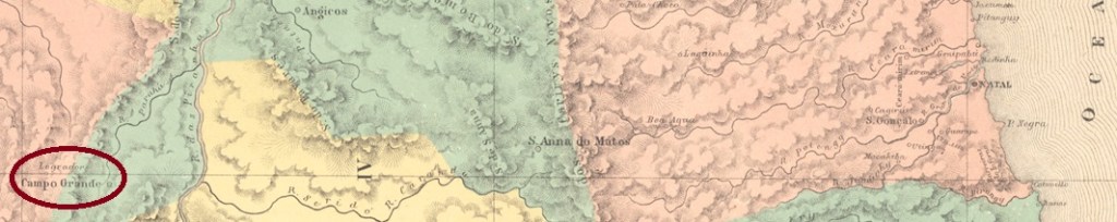
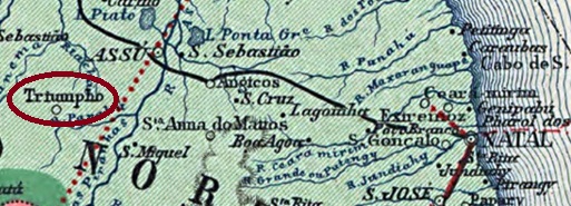
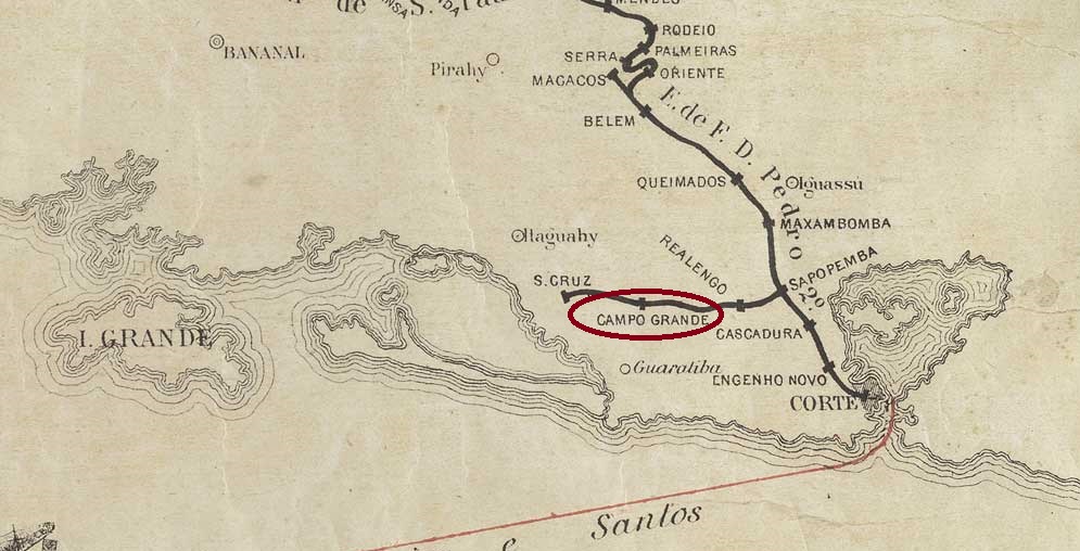
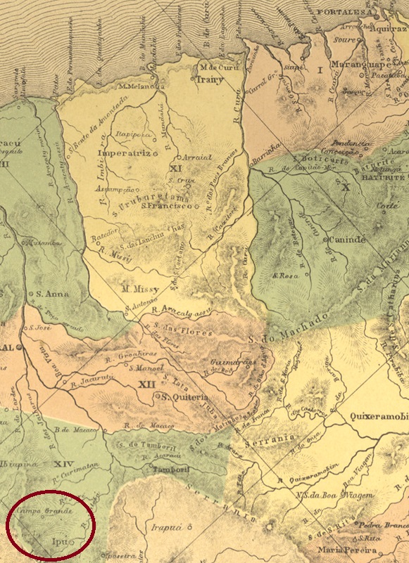
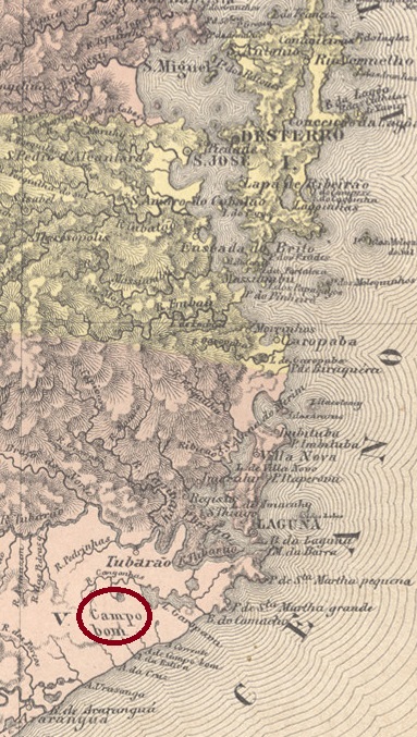
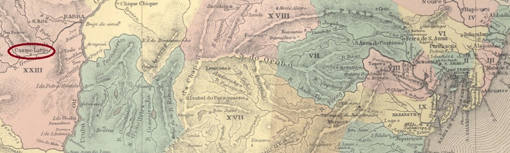
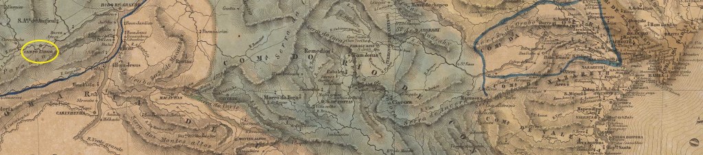
The former Freguesia de Sant’Anna do Campo Largo belonged to the Vila da Barra do Rio Grande and was located on the north bank of the Rio Grande, 870 km west of the provincial capital Salvador da Bahia. It was elevated to vila status in March 1820, but lost this status in June 1925 when it became a district of the Município Barão de Cotegipe. After that, not much changed until December 1943, when it was renamed Taguá. The indigenous word of the Tupi-Guarani language refers to the South American wild boar.

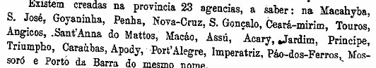
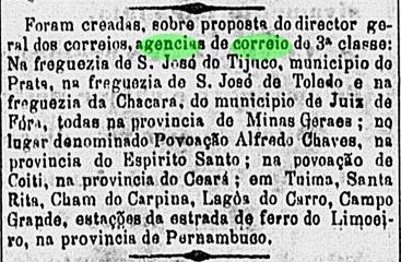
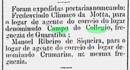
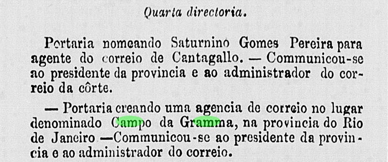
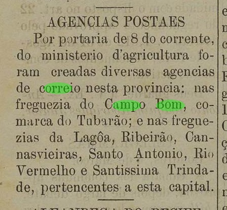
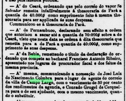
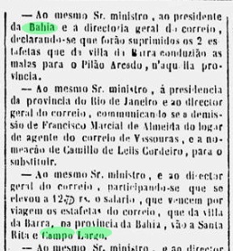
Three dates have been found for the founding of the post office. First in 1855, as noted in the Directory of Imperial Post Offices (Tabella das Agencias do Correio do Imperio, Rio de Janeiro, 1885). This information is indirectly confirmed by a newspaper note from Rio in which the postal official in charge is named:

Jornal do Commercio/RJ, 16.08.1855

Nova Monteiro gives April 1866 in Administrações e Agencias Postaes do Brasil Imperio (Brasil Filatelico/RJ, 1934-5; Reprint SPP 1994-1999), while R. Koester in Carimbologia VIII writes February 1881 for it. Since the postal agency is mentioned in the postal guides of 1857 (Guia do Correio do Brasil) and 1880 (Guia Postal do Imperio), it can be assumed that it was opened and closed several times.

However, there was a postal service as early as May 1852, as can be seen from the Rio press:

Diario do Rio de Janeiro, 25.05.1852

So far, no imperial postmarks are known from this place.

Villiers de l’Ile Adam: Carta (…) da Provincia da Bahia, 1848

Anderer Name: Taguá (1943)

Die ehemalige Freguesia de Sant’Anna do Campo Largo gehörte zur Vila da Barra do Rio Grande und lag am Nordufer des Rio Grande, 870 km westlich der Provinzhauptstadt Salvador da Bahia. Es wurde im März 1820 zur Vila erhoben, verlor diesen Status aber im Juni 1925, als es zum Distrikt des Município Barão de Cotegipe wurde. Danach änderte sich nicht viel, bis im Dezember 1943 die Umbenennung in Taguá erfolgte. Das indigene Wort der Tupi-Guarani-Sprache bezeichnet das südamerikanische Wildschwein.

Für die Gründung des Postamtes wurden drei Daten gefunden. Erstmals 1855, wie im Verzeichnis der kaiserlichen Postämter (Tabella das Agencias do Correio do Imperio, Rio de Janeiro, 1885) vermerkt. Diese Angabe wird indirekt durch eine Zeitungsnotiz aus Rio bestätigt, in der der zuständige Postbeamte genannt wird:

Jornal do Commercio/RJ, 16.08.1855

Nova Monteiro nennt den April 1866 in Administrações e Agencias Postaes do Brasil Imperio (Brasil Filatelico/RJ, 1934-5; Reprint SPP 1994-1999), während R. Koester in Carimbologia VIII den Februar 1881 angibt. Da die Postagentur in den Postführern von 1857 (Guia do Correio do Brasil) und 1880 (Guia Postal do Imperio) erwähnt wird, ist davon auszugehen, dass sie mehrmals eröffnet und auch wieder geschlossen wurde.

Es gab jedoch bereits im Mai 1852 einen Postdienst, wie aus der Presse von Rio hervorgeht:

Diario do Ro de Janeiro, 25.05.1882

Bisher sind keine kaiserlichen Poststempel aus diesem Ort bekannt.

Categories
Carimbologia C-D

Campo Grande, Rio Grande do Norte (CRN-0040)

Atlas do Imperio do Brasil, 1868

Other names: Triumpho, Augusto Severo (1903-2019)

See also Triumpho (TRN-0175)

This locality was the district of Sant’Anna do Campo Grande in the Município of Caraúbas, 280 km west of the provincial capital of Natal, from October 1837. In September 1858, the place rose to a villa called Campo Grande, but in March 1868 it was downgraded again as a district of Caraúbas. Two years later, in May 1870, it rose again to Villa, which was renamed Augusto Severo in August 1903. The name celebrated Augusto Severo de Albuquerque Maranhão (1864-1902), a politician, journalist inventor and airship builder born in Rio Grande do Norte. Nevertheless, in June 2019, the Município regained its old name of Campo Grande.

Augusto Severo (Musée de l’Air et de l’Espace)

Three foundations for the local post office were found. First in September 1836, still under the place name Campo Grande, as stated by both Reinhold Koester (Carimbologia VIII) and the Directory of Imperial Post Offices (Tabella das Agencias do Correio do Imperio, Rio de Janeiro, 1885). Then again in February 1843, as Nova Monteiro writes in Administrações e Agencias Postaes do Brasil Imperio (in Brasil Filatelico/RJ, 1934-5; reprint SPP 1994-1999). And most recently around 1871, now under the toponym Triumpho, as shown in the provincial president’s report for 1872:

Relatorio do Presidente da Provincia/RN, October 1872

So far, no imperial postmark could be assigned to this locality with certainty.

Carta da republica dos Estados Unidos do Brazil, 1892

Andere Namen: Triumpho, Augusto Severo (1903-2019)

Siehe auch Triumpho (TRN-0175)

Diese Ortschaft war ab Oktober 1837 der Distrikt von Sant’Anna do Campo Grande im Município von Caraúbas, der 280 km westlich der Provinzhauptstadt Natal entfernt lag. Im September 1858 stieg der Ort zu einer Villa namens Campo Grande, wurde aber im März 1868 wieder als Distrikt von Caraúbas herabgesetzt. Zwei Jahre später, im Mai 1870 erfolgte erneut der Aufstieg zu Villa, die im August 1903 zu Augusto Severo umbenannt wurde. Der Name erinnerte an Augusto Severo de Albuquerque Maranhão (1864-1902), einem Politiker, Journalist Erfinder und Luftschiffbauer, der in Rio Grande do Norte geboren wurde. Dennoch, im Juni 2019 erhielt der Município den alten Namen Campo Grande zurück.

Augusto Severo (Musée de l’Air et de l’Espace)

Drei Gründungen fürs örtliche Postamt wurden gefunden. Erstmals im September 1836, noch unter dem Ortsnamen Campo Grande, wie sowohl Reinhold Koester (Carimbologia VIII) als auch das Verzeichnis der kaiserlichen Postämter (/Tabella das Agencias do Correio do Imperio, Rio de Janeiro, 1885) übereinstimmend berichten. Dann wieder im Februar 1843, wie Nova Monteiro in Administrações e Agencias Postaes do Brasil Imperio (in Brasil Filatelico/RJ, 1934-5; Reprint SPP 1994-1999) schreibt. Und zuletzt um ca. 1871, nun unter dem Ortsnamen Triumpho, wie aus dem Bericht des Provinzpräsidenten für 1872 hervorgeht:

Relatorio do Presidente da Provincia/RN, Oktober 1872

Bisher konnte kein kaiserlicher Poststempel dieser Ortschaft mit Sicherheit zugeordnet werden.

Categories
Carimbologia C-D

Campo Grande (train station/Bahnhof), Município Neutro (CMN-0080)

Estações (…) do Rio de Janeio, São Paulo e Minas Geraes, 1880

Campo Grande station was opened in December 1878 by the E.F. D. Pedro II (branch Mangaratiba or Santa Cruz) in the freguesia of the same name, 50 km west of the capital Rio de Janeiro. The line passed to E.F. Central do Brasil in 1889, to Rede Ferroviária Federal S.A. in 1975 and has been operated by the Supervias consortium since 1997.

Around 1930 (Photo: Claudio M. Falcão on estacoesferroviarias.com.br)
In 2008 (Photo: Anderson on estacoesferroviarias.com.br)

An exact creation date for the station post office has not yet been found, but it is likely to have been 1879, as this office is already mentioned in the imperial postal guide (Guia Postal do Imperio, Rio de Janeiro, 1880). Reinhold Koester has shown the first postmarks of this agency in Carimbologia VIII:

CMN-0080a (RK) 1879ff
CMN-0080b (RK) 1887
Mappa do Municipio Neutro, ca. 1880

Der Bahnhof Campo Grande wurde im Dezember 1878 von der E.F. D. Pedro II (Abzweigung Mangaratiba bzw. Santa Cruz) eröffnet und lag in der gleichnamigen Freguesia, 50 km westlich der Hauptstadt Rio de Janeiro. Die Strecke ging 1889 an die E.F. Central do Brasil, 1975 an die Rede Ferroviária Federal S.A. über und wird seit 1997 vom Konsortium Supervias betrieben.

Um 1930 (Foto: Claudio M. Falcão auf estacoesferroviarias.com.br)
2008 (Foto: Anderson auf estacoesferroviarias.com.br)

2008 (Foto: Anderson auf estacoesferroviarias.com.br)

Ein genaues Gründungsdatum für das Bahnhofspostamt konnte noch nicht gefunden werden, es dürfte aber 1879 gewesen sein, da dieses Amt bereits im kaiserlichen Postführer (Guia Postal do Imperio, Rio de Janeiro, 1880) erwähnt wird. Reinhold Koester hat in Carimbologia VIII die ersten Poststempel dieser Agentur gezeigt:

CMN-0080a (RK) 1879ff
CMN-0080b (RK) 1887
Categories
Carimbologia C-D

Campo Grande (train station/Bahnhof), Pernambuco (CPE-0160)

Rede Ferroviaria de Pernambuco, 1898 (IBGE)

Campo Grande station was inaugurated in February 1882 by the E.F. Recife ao Limoeiro (Great Western, Nazareth branch railway) railway company in the Freguesia de N. Sra. da Graça in the Município Nazareth. The line belonged to Rede Ferroviária do Nordeste from 1950 until its closure. From December 1958, the station was in the Município Lagoa do Carro. Today, the tracks have disappeared and the station building serves as a primary school (estacoesferroviarias.com.br).

In 2009 (Photo: Sydney Correia on estacoesferroviarias.com.br)

As reported by the Rio press, there was a post office at the station from October 1882:

O Globo/RJ, Oct 28, 1882

Until now, no imperial postmark from Campo Grande station was known.

Arthur D. Ribeiro: Estado de Pernambuco, 1924

Der Bahnhof Campo Grande wurde im Februar 1882 von der Eisenbahngesellschaft E.F. Recife ao Limoeiro (Great Western, Nazareth-Abzweigung) eingeweiht und befand sich in der Freguesia de N. Sra. da Graça im Município Nazareth. Die Strecke gehörte von 1950 bis zu ihrer Stilllegung zur Rede Ferroviária do Nordeste. Ab Dezember 1958 lag der Bahnhof im Município Lagoa do Carro. Heute sind die Gleise verschwunden, das Bahnhofsgebäude dient als Grundschule (estacoesferroviarias.com.br).

2009 (Foto: Sydney Correia, auf estacoesferroviarias.com.br)

Wie die Presse in Rio berichtete, gab es ab Oktober 1882 ein Postamt am Bahnhof:

O Globo/RJ, 28.10.1882

Bisher war kein kaiserlicher Poststempel vom Bahnhof Campo Grande bekannt.

Categories
Carimbologia C-D

Campo Grande, Ceará (CCE-0075)

Atlas do Imperio do Brasil, 1868

Other names: Villa Nova, Campo Grande, Inhussu, Guaraciaba do Norte (1951)

See also Villa Nova/CE (VCE-0373) and Ipu (R. Koester: Carimbologia XXII)

Here we have another old village with a confused history. It began in 1760 with the construction of the chapel of Nossa Sra. dos Prazeres, which was located on the eastern slope of the Serra da Ibiapaba (or Serra Grande), barely 300 km west of the later provincial capital Fortaleza. In May 1791, the growing village called Campo Grande was elevated to Villa Nova d’El-Rey. After the colonial period, the royal name was no longer welcome, so in August 1840 the local administration changed to the neighbouring village of Ipu – now called Villa Nova do Ipú Grande. There must have been a strong rivalry between the two places, because immediately in January 1841 the old Villa Nova d’El-Rey became politically independent again, now as Villa de Campo Grande. This independence did not last long: in December 1842 Campo Grande was downgraded to the district of Ipu. And it remained so until January 1879, when the Vila of Campo Grande was created once again. After that, the place name changed twice: in December 1943 to Inhussu and in November 1951 to Guaraciaba do Norte, which is still current today. The name Guaraciaba has Indian origins and is said to mean golden hair.

The local post office was established in February 1832, as R. Koester writes in Carimbologia XXII. The year is confirmed in the Directory of Imperial Post Offices (Tabella das Agencias do Correio do Imperio, Rio de Janeiro, 1885). So far, no imperial postmark from this vila could be found.

Villiers de l’Ile Adam: Carta (…) da Provincia do Ceará, 1849

Andere Namen: Villa Nova, Campo Grande, Inhussu, Guaraciaba do Norte (1951)

Siehe auch Villa Nova/CE (VCE-0373) und Ipu (R. Koester: Carimbologia XXII)

Hier haben wir wieder eine alte Ortschaft mit konfuser Geschichte. Diese fing 1760 mit der Errichtung der Kapelle Nossa Sra. dos Prazeres an, die am Osthang der Serra da Ibiapaba (oder auch Serra Grande) lag, knapp 300 km westlich der späteren Provinzhauptstadt Fortaleza entfernt. Im Mai 1791 wurde der wachsende Ort namens Campo Grande zur Villa Nova d’El-Rey erhoben. Nach der Kolonialzeit war der Königsname nicht mehr erwünscht, also wechselte im August 1840 die Ortsverwaltung zum Nachbarort Ipu – nun unter dem Namen Villa Nova do Ipú Grande. Es musste eine starke Rivalität zwischen beiden Orten vorhanden sein, denn gleich im Januar 1841 wurde die alte Villa Nova d’El-Rey wieder politisch selbständig, jetzt als Villa de Campo Grande. Diese Selbständigkeit dauerte nicht lange: im Dezember 1842 wurde Campo Grande zum Distrikt von Ipu herabgestuft. Und so blieb es bis Januar 1879, als die Vila von Campo Grande abermals ins Leben gerufen wurde. Danach wechselte der Ortsname zweimal: im Dezember 1943 zu Inhussu und im November 1951 zum heute noch aktuellen Guaraciaba do Norte. Der Name Guaraciaba hat indianischen Ursprung und soll goldene Haare bedeuten.

Das örtliche Postamt entstand im Februar 1832, wie R. Koester in Carimbologia XXII schreibt. Das Jahr wird im Verzeichnis der kaiserlichen Postämter (Tabella das Agencias do Correio do Imperio, Rio de Janeiro, 1885) bestätigt. Bisher konnte kein kaiserlicher Poststempel aus dieser Vila gefunden werden.

Categories
Carimbologia C-D

Campo Formoso, Bahia (CBA-0225)

Mappa Geral do Brasil, 1911

Another name: Santo Antonio da Jacobina

The Freguesia Velha de Santo Antonio da Jacobina, founded in June 1838, belonged to Villa Nova da Rainha (today: Bonfim) and was located on the east bank of the Rio do Aipim, 470 km northwest of the provincial capital Salvador da Bahia. The place was declared Villa da Campo Formoso (Beautiful Field) in June 1880 and has been a town since March 1938.

The local post office was opened in October 1889, as shown in the postal bulletin (Boletim Postal) of the following month:

Boletim Postal No. 7, Nov. 1889

No imperial postmark from Campo Formoso has yet been seen, it must be extremely rare.

Estado da Bahia, 1913

Anderer Name: Santo Antonio da Jacobina

Die im Juni 1838 gegründete Freguesia Velha de Santo Antonio da Jacobina gehörte zu Villa Nova da Rainha (heute: Bonfim) und lag am Ostufer des Rio do Aipim, 470 km nordwestlich der Provinzhauptstadt Salvador da Bahia. Der Ort wurde im Juni 1880 zur Villa da Campo Formoso (Schönes Feld) erklärt und ist seit März 1938 eine Stadt.

Das örtliche Postamt wurde im Oktober 1889 eröffnet, wie aus dem Postbulletin (Boletim Postal) des folgenden Monats hervorgeht:

Boletim Postal Nr. 7, November 1889

Boletim Postal Nr. 7, Nov. 1889

Bisher wurde noch kein kaiserlicher Poststempel aus Campo Formoso gesehen, er muss äußerst selten sein.

Categories
Carimbologia C-D

Campo do Collegio, Município Neutro (CMN-0075)

Mappa do Municipio Neutro, ca. 1875

Here we have another place in the Brazilian Empire about which next to nothing is known, neither about the time of its origin nor why there was a post office there at all. Campo do Collegio (School Field) was on the freguesia of Guaratiba on the way to Sepetiba, 65 km west of the capital Rio de Janeiro. It has remained that way until today, except that the beautiful landscape of that time has probably been irretrievably lost.

As Reinhold Koester writes in Carimbologia VIII, there had been a post office there since January 1887, and its first agent was soon introduced in the capital’s press:

O Paiz/RJ, 05.02.1887

The post office was closed in July 1907, as Paulo Novaes writes on agenciaspostais.com.br. The only imperial postmark is CMN-0075a, as shown to us by Koester:

CMN-0075a (RK)
Ca. 1920 (agenciaspostais.com.br)

Hier haben wir einen weiteren Ort im brasilianischen Kaiserreich, über den so gut wie nichts bekannt ist, weder über die Entstehungszeit noch darüber, warum es dort überhaupt ein Postamt gab. Campo do Collegio (Schulfeld) lag an der Freguesia von Guaratiba auf dem Weg nach Sepetiba, 65 km westlich der Hauptstadt Rio de Janeiro. Das ist bis heute so geblieben, nur dass die schöne Landschaft von damals wohl unwiederbringlich verloren gegangen ist.

Wie Reinhold Koester in Carimbologia VIII schreibt, gab es dort seit Januar 1887 ein Postamt, dessen erster Agent bald in der Hauptstadtpresse vorgestellt wurde:

O Paiz/RJ, 05.02.1887

Das Postamt wurde im Juli 1907 geschlossen, wie Paulo Novaes auf agenciaspostais.com.br schreibt. Der einzige kaiserliche Poststempel ist der Siegel CMN-0075a, den uns Koester gezeigt hat:

CMN-0075a (RK)
Categories
Carimbologia C-D

Campo da Gramma, Rio de Janeiro (CRJ-0270)

Almanak Laemmert, 1892

Other names: Luiz Gomes, Hermogênio Silva (1915)

Campo da Gramma (Turf Field) was a small settlement of the Freguesia de Bemposta, then part of the Vila de Parahyba do Sul, located on the east bank of the Piabanha, 120 km north of the capital Rio de Janeiro. In 1861, an estação (road stop, not a railway station) was built there by the company União e Industria. This was Brazil’s first paved trunk road, a prestigious project that was to connect the town of Petropolis in Rio with Juiz der Fora in the province of Minas Gerais by stagecoach.

The local stop was to be called Luiz Gomes, after a local fazendeiro, but this name was largely ignored. Instead, the Estação continued to be called Campo da Gramma. The E.F. Leopoldina railway line did not arrive until 1900, and the station was called Hermogênio Silva from 1915, after a mayor of Petrópolis who had died shortly before. Since December 1938, the village has belonged to the Município Três Rios.

The local post office was created in July 1861, according to the administrative report of the time:

Boletim do Expediente do Governo, July 1861

The first postmark is CRJ-0270a, which also existed in green, blue and dark purple until at least 1876. Here the illustration from Catálogo de Carimbos Brasil-Império (S. Paulo, 1937, 1942), by Paulo Ayres:

CRJ-0270a (P.A. 1253) 1861-1876

The following two postmarks CRJ-0120b and CRJ-0120c were also recorded by P. Ayres:

CRJ-0120b (P.A. p. 121) 1878-1879
CRJ-0120c (P.A. p. 120) 1884-1889

James Dingler and Klerman W. Lopes have listed two mute cancellations from Campo da Gramma in Mute Cancellations of the Brazil Empire / Carimbos Mudos do Brasil Império (Brazil Philatelic Association, Rio de Janeiro, 2000):

BPA 472 and 733 (1882ff-1884)
Atlas do Imperio do Brasil, 1868

Andere Namen: Luiz Gomes, Hermogênio Silva (1915)

Campo da Gramma (Rasenfeld) war eine kleine Siedlung der Freguesia de Bemposta, die damals zur Vila de Parahyba do Sul gehörte und am Ostufer des Piabanha, 120 km nördlich der Hauptstadt Rio de Janeiro, lag. Im Jahre 1861 wurde dort eine Estação (Haltestelle, kein Bahnhof) der Gesellschaft União e Industria gebaut. Es handelte sich um die erste befestigte Fernstraße Brasiliens, ein Prestigeprojekt, das die Stadt Petropolis in Rio mit Juiz der Fora in der Provinz Minas Gerais durch einen Postkutschendienst verbinden sollte.

Die örtliche Haltestelle sollte Luiz Gomes heißen, nach einem Fazendeiro der Region, aber dieser Name wurde weitgehend ignoriert. Stattdessen hieß die Estação weiterhin Campo da Gramma. Die Eisenbahnlinie der E.F. Leopoldina kam erst 1900, und der Bahnhof hieß ab 1915 Hermogênio Silva, nach einem kurz zuvor verstorbenen Bürgermeister von Petrópolis. Seit Dezember 1938 gehört der Ort zum Município Três Rios.

Das örtliche Postamt wurde im Juli 1861 gegründet, wie aus einem damaligen Verwaltungsbericht hervorgeht:

Boletim do Expediente do Governo, 07.1861

Der erste Poststempel ist CRJ-0270a, den es bis mindestens 1876 auch in den Farben grün, blau und dunkelviolett gab. Hier die Abbildung aus Catálogo de Carimbos Brasil-Império (S. Paulo, 1937, 1942), von Paulo Ayres:

CRJ-0270a (P.A. 1253) 1861-1876

Die beiden folgenden Stempel CRJ-0120b und CRJ-0120c wurden ebenfalls durch P. Ayres erfasst:

CRJ-0120b (P.A. S. 121) 1878-1879
CRJ-0120c (P.A. S. 120) 1884-1889

James Dingler und Klerman W. Lopes haben in Mute Cancellations of the Brazil Empire / Carimbos Mudos do Brasil Império (Brazil Philatelic Association, Rio de Janeiro, 2000) zwei stumme Entwertungen aus Campo da Gramma aufgelistet:

BPA 472 und 733 (1882ff-1884)

Categories
Carimbologia C-D

Campo Bom, Santa Catarina (CSC-0040)

Estado de Santa Catharina, 1907

See also Jaguaruna (R. Koester: Carimbologia XXV)

This Campo Bom of the imperial province of Santa Catarina was a settlement of the Vila de Laguna, 160 km south of the provincial capital Desterro (today: Florianópolis), from about 1869. In March 1880 it was declared a Freguesia de N. Sra. das Dores de Jaguaruna and in January 1891 it was elevated to the status of Vila. Between August 1923 and December 1930, it was downgraded to the District of Laguna, before regaining the Município status.

There was a post office since March 1884, according to the regional press:

Jornal do Commercio/SC, 14/03/1884

It is remarkable that the place was still mentioned as Campo Bom, although at that time the new official name Jaguaruna had already been in force for four years. It is therefore possible that there is an imperial postmark under Campo Bom, especially as Jaguaruna postmarks are only known from 1890 onwards.

Atlas do Imperio do Brasil, 1868

Siehe auch Jaguaruna (R. Koester: Carimbologia XXV)

Dieser Campo Bom der kaiserlichen Provinz Santa Catarina war ab etwa 1869 eine Siedlung der Vila de Laguna, 160 km südlich der Provinzhauptstadt Desterro (heute: Florianópolis). Im März 1880 wurde sie zur Freguesia de N. Sra. das Dores de Jaguaruna erklärt und im Januar 1891 zur Vila erhoben. Zwischen August 1923 und Dezember 1930 wurde sie zum Distrikt von Laguna herabgestuft, bevor sie den Status eines Município wiedererlangte.

Seit März 1884 gab es dort ein Postamt, wie die regionale Presse berichtet:

Jornal do Commercio/SC, 14.03.1884

Bemerkenswert ist, dass der Ort noch als Campo Bom erwähnt wurde, obwohl zu diesem Zeitpunkt der neue offizielle Name Jaguaruna bereits seit vier Jahren in Kraft war. Es ist daher möglich, dass es einen kaiserlichen Poststempel unter Campo Bom gibt, zumal Jaguaruna-Stempel erst ab 1890 bekannt sind.

Categories
Carimbologia C-D

Campo Bom, Rio Grande do Sul (CRS-0075)

Estado do Rio Grande do Sul, 1924

Other names: Cambará, Cambará do Sul (1963)

This Campo Bom (Good Field) in the imperial province of Rio Grande do Sul is not the município of the same name of today (this is a former district of São Leopoldo), but the former Freguesia de S. José do Campo Bom, founded in April 1884 in the Vila of S. Francisco de Paula de Cima da Serra, 200 km northeast of the provincial capital Porto Alegre. In contrast to the other Campo Bom, the older settlement developed very slowly: in October 1950 it was renamed Cambará and has been Município Cambará do Sul since December 1963. Cambará is the Tupi name for Moquiniastrum polymorphum (Less./G. Sancho), a Brazilian tree from the Asteraceae family that provides good timber:

Moquiniastrum polymorphum (Photo: edilqueirozdearaujo@Mapillary.com, CC BY-SA 4.0)

As R. Koester writes in Carimbologia VIII, there was a post office there from October 1887. The only postmark so far is CRS-0075a shown in Koester (op. cit.):

CRS-0075a (RK)
Google Maps

Andere Namen: Cambará, Cambará do Sul (1963)

Dieses Campo Bom (Gutes Feld) in der kaiserlichen Provinz Rio Grande do Sul ist nicht der gleichnamige Município von heute (dieser ist ein ehemaliger Distrikt von São Leopoldo), sondern die ehemalige Freguesia de S. José do Campo Bom, gegründet im April 1884 in der Vila von S. Francisco de Paula de Cima da Serra, 200 km nordöstlich der Provinzhauptstadt Porto Alegre. Im Gegensatz zum anderen Campo Bom entwickelte sich die ältere Siedlung sehr langsam: Im Oktober 1950 wurde sie in Cambará umbenannt und ist seit Dezember 1963 Município Cambará do Sul. Cambará ist die Tupi-Bezeichnung für Moquiniastrum polymorphum (Less./G. Sancho), einen brasilianischen Baum aus der Familie der Asteraceae, der gutes Bauholz liefert:

Moquiniastrum polymorphum (Foto: edilqueirozdearaujo@Mapillary.com, CC BY-SA 4.0)

Wie R. Koester in Carimbologia VIII schreibt, gab es dort ab Oktober 1887 ein Postamt. Der bisher einzige Poststempel ist der bei Koester (op. cit.) gezeigte Siegel CRS-0075a:

CRS-0075a (RK)