Categories
Carimbologia C-D

Campestre, Minas Gerais (CMG-0505)

Atlas do Imperio do Brasil, 1868

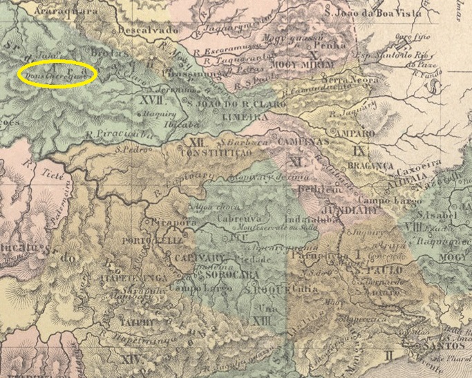
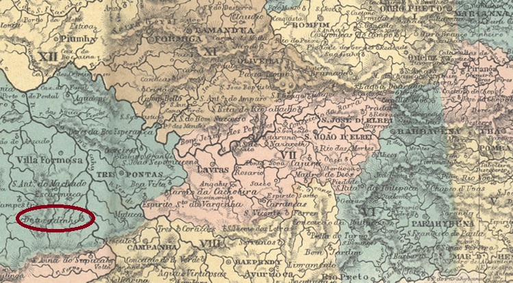
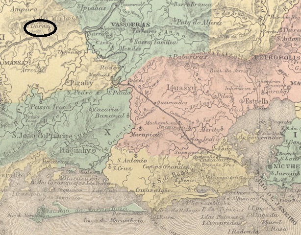
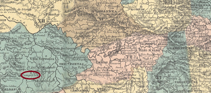
The Freguesia de N. Sra.do Carmo do Campestre was founded in April 1840, belonged to the Vila de Caldas and was situated on the Ribeirão Campestre, a tributary of the Rio do Peixe, 450 km southwest of the provincial capital Ouro Preto. It was elevated to the status of a vila in its own município in August 1911 and has been called Campestre for short since September 1923.

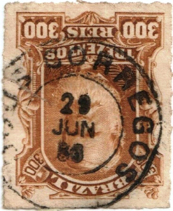
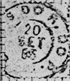
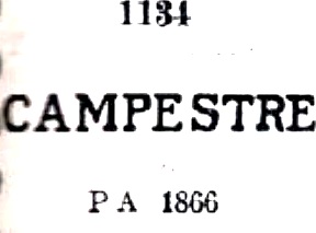
According to the postal report (Relatorio Postal) for 1887, there had been a post office there since February 1872. The oldest postmark is CMG-0505a and was registered in the Catálogo de Carimbos Brasil-Império by Paulo Ayres (S. Paulo, 1937, 1942) under No. 1134:

CMG-0505a (P.A. 1134) 1872ff

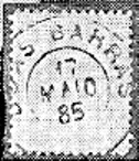
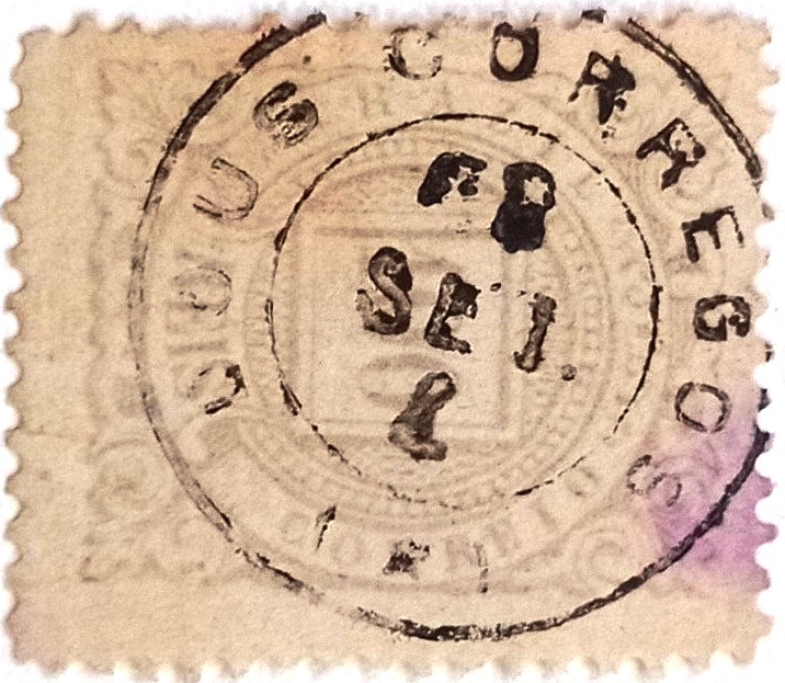
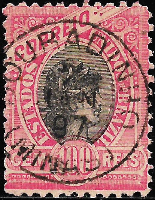
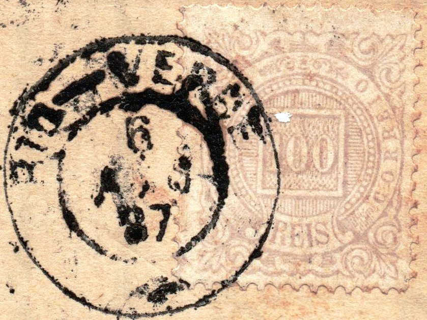
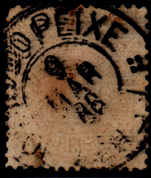
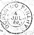
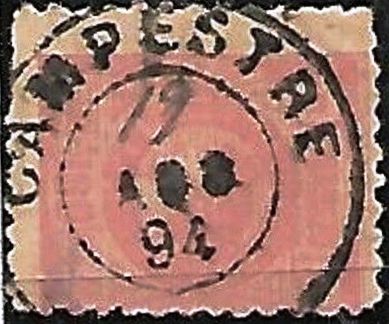
It was followed by CMG-0505b, (image by Marcio Duarte):

CMG-0505b (MD) 1888

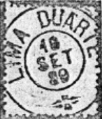
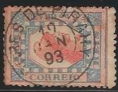
The next cancel could already be republican, because the dates of CMG-0505c (fig. from the internet) range from 1894 to 1896:

CMG-0505c (EB) 1894-1896
Villiers de l’Ile Adam: Carta (…) da Provincia de Minas Geraes, 1849

Die Freguesia de N. Sra.do Carmo do Campestre wurde im April 1840 gegründet, gehörte zur Vila de Caldas und lag am Ribeirão Campestre, einem Nebenfluss des Rio do Peixe, 450 km südwestlich der Provinzhauptstadt Ouro Preto. Sie wurde im August 1911 zur Vila im eigenen Município erhoben und heißt seit September 1923 abgekürzt Campestre.

Wie aus dem Postbericht (Relatorio Postal) für 1887 hervorgeht, gab es dort ein Postamt seit Februar 1872. Der älteste Poststempel ist CMG-0505a und wurde im Catálogo de Carimbos Brasil-Império von Paulo Ayres (S. Paulo, 1937, 1942) unter der Nr. 1134 registriert:

CMG-0505a (P.A. 1134) 1872ff

Ihm folgte CMG-0505b (Abb. Marcio Duarte):

CMG-0505b (MD) 1888

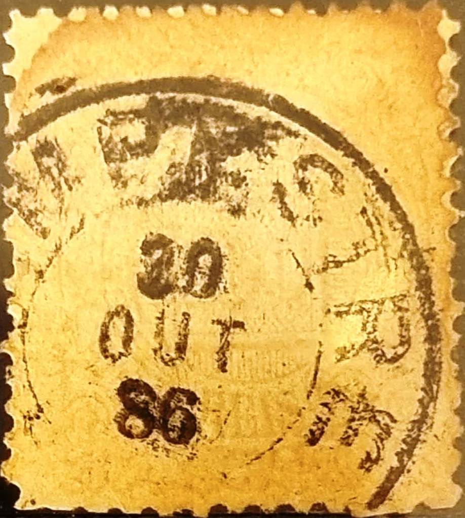
Der nächste Stempel dürfte bereits republikanisch sein, denn die Daten von CMG-0505c (Abb. aus dem Internet) reichen von 1894 bis 1896:

CMG-0505c (EB) 1894-1896
Categories
Carimbologia C-D

Duas Barras, Rio de Janeiro (DRJ-0365)

Almanak Laemmert, 1892

See also Conceição das Duas Barras do Rio Negro (CRJ-0365)

The small chapel was built in December 1836 near the Vila de Cantagalo on the west bank of the Rio Negro, approx. 180 km north-east of the capital Rio de Janeiro. In October 1856, the Freguesia de N. Sra. da Conceição das Duas Barras was founded there, which was declared a vila in May 1891 and a town in December 1929.

The local post office had existed since November 1861, as reported in the regional press:

Jornal do Commercio, 07/11/1861

The first postmark is CRJ-0365a (fig. R. Koester, in Carimbologia XIII):

CRJ-0365a (RK) 1861-1866ff

Koester also shows the seal cancel CRJ-0365b:

CRJ-0365b (RK)

In the next postmark DRJ-0365a (fig. R. Koester, op.cit.) the place name is already abbreviated:

DRJ-0365a (RK) 1884ff-1892
Atlas do Imperio do Brasil, 1868

Siehe auch Conceição das Duas Barras do Rio Negro (CRJ-0365)

Die kleine Kapelle wurde im Dezember 1836 erbaut und lag nahe der Vila de Cantagalo am Westufer des Rio Negro, ca. 180 km nordöstlich der Hauptstadt Rio de Janeiro. Im Oktober 1856 wurde dort die Freguesia de N. Sra. da Conceição das Duas Barras gegründet, die im Mai 1891 zur Vila und im Dezember 1929 zur Stadt erklärt wurde.

Das örtliche Postamt bestand seit November 1861, wie die regionale Presse berichtete:

Jornal do Commercio, 07.11.1861

Der erste Poststempel ist CRJ-0365a (Abb. R. Koester, in Carimbologia XIII):

CRJ-0365a (RK) 1861-1866ff

Koester zeigt auch den Siegelstempel CRJ-0365b:

CRJ-0365b (RK)

Beim nächsten Stempel DRJ-0365a (Abb. R. Koester, op.cit.) ist der Ortsname bereits abgekürzt:

DRJ-0365a (RK) 1884ff-1892
Categories
Carimbologia C-D

Duas Barras, Bahia (DBA-0345)

Estado da Bahia, 1913

Other names: Urandi (1918)

Santo Antonio das Duas Barras was a freguesia of the Vila de Caetité from May 1877, near the provincial border with Minas Gerais, 710 km south-west of the capital Salvador da Bahia. The municipality was incorporated into the newly founded Vila de Umburanas in July 1889 and has been Município de Urandi since August 1918. The name comes from the Indian language Tupi and means black wood.

R. Koester writes in Carimbologia XVI that there has been a post office there since January 1887. This is confirmed by the press in Rio:

Gazeta de Noticias/RJ, 04/01/1877

No imperial postmarks are yet known from Duas Barras in the province of Bahia.

Laemmert: Estado da Bahia, 1913

Andere Namen: Urandi (1918)

Santo Antonio das Duas Barras war ab Mai 1877 eine Freguesia der Vila de Caetité, nahe der Provinzgrenze zu Minas Gerais, 710 km südwestlich der Hauptstadt Salvador da Bahia. Die Gemeinde wurde im Juli 1889 in die neu gegründete Vila de Umburanas eingegliedert und ist seit August 1918 Município de Urandi. Der Name stammt aus der Indianersprache Tupi und bedeutet schwarzes Holz.

R. Koester schreibt in Carimbologia XVI, dass es dort seit Januar 1887 ein Postamt gab. Dies wird von der Presse in Rio bestätigt:

Gazeta de Noticias/RJ, 04.01.1877

Aus Duas Barras in der Provinz Bahia sind bisher keine kaiserlichen Poststempel bekannt.

Categories
Carimbologia C-D

Dous Corregos, São Paulo (DSP-0440)

Mappa da Provincia de São Paulo, 1886

The Espirito Santo dos Dous (also Dois) Córregos chapel was built in February 1856 in Vila de Brotas, 270 kilometres northwest of the provincial capital of São Paulo. The two streams (Dois Córregos) were called Córrego Fundo and Córrego Lageado and flowed into the Rio do Peixe (today: Rio Jaú). The village became a parish in March 1865, a vila in April 1874 and a town in October 1898.

R. Koester writes in Carimbologia XVI that there had been a post office there since 1872. This is confirmed by the regional press:

Diario de São Paulo, 20/03/1872

The oldest postmark to date is DSP-0440a (image from the Internet):

DSP-0440a (EB) 1877-1887

This was followed by DSP-0440b (illustration by Mário Celso Orsi Jr.):

DSP-0440b (MO) 1889-1893
Atlas do Imperio do Brasil, 1868

Die Kapelle Espirito Santo dos Dous (auch Dois) Córregos wurde im Februar 1856 in Vila de Brotas, 270 km nordwestlich der Provinzhauptstadt São Paulo, errichtet. Die beiden Bäche (Dois Córregos) hießen Córrego Fundo und Córrego Lageado und flossen in den Rio do Peixe (heute: Rio Jaú). Der Ort wurde im März 1865 zur Pfarrei, im April 1874 zur Vila und im Oktober 1898 zur Stadt erhoben.

R. Koester schreibt in Carimbologia XVI, dass es dort seit 1872 ein Postamt gab. Dies wird von der regionalen Presse bestätigt:

Diario de São Paulo, 20.03.1872

Der bisher älteste Poststempel ist DSP-0440a (Abb. aus dem Internet):

DSP-0440a (EB) 1877-1887

Es folgte DSP-0440b (Abb. Mário Celso Orsi Jr.):

DSP-0440b (MO) 1889-1893
Categories
Carimbologia C-D

Douradinho, Minas Gerais (DMG-1090)

Atlas do Imperio do Brasil, 1868

S. João Baptista do Douradinho had been a parish of the Vila de Ouro Fino since October 1813, situated between the Dourado and Sapucaí rivers, 400 kilometres southwest of the later provincial capital of Ouro Preto. In November 1842, the village was elevated to a freguesia, which then belonged to the Vila de Campanha, and changed jurisdiction again in November 1880, then to Sto. Antonio do Machado. Since September 1923, Douradinho has been a Distrito in the Município de Machado.

Here, too, Paula Sobrinho (História Postal de Minas Gerais, Belo Horizonte, 1997) and R. Koester (Carimbologia XVI) agree that there has been a post office since April 1885. The oldest postmark to date is DMG-1090a (image from the Internet):

DMG-1090a (EB) 1897
Villiers de l’Ile Adam: Carta (…) da Provincia de Minas Geraes, 1849

S. João Baptista do Douradinho war seit Oktober 1813 eine Pfarrei der Vila de Ouro Fino, gelegen zwischen den Flüssen Dourado und Sapucaí, 400 km südwestlich der späteren Provinzhauptstadt Ouro Preto. Im November 1842 wurde der Ort zur Freguesia erhoben, die nun zur Vila de Campanha gehörte, und wechselte im November 1880 erneut die Zuständigkeit, dann zu Sto. Antonio do Machado. Seit September 1923 ist Douradinho ein Distrito im Município de Machado.

Auch hier sind sich Paula Sobrinho (História Postal de Minas Gerais, Belo Horizonte, 1997) und R. Koester (Carimbologia XVI) einig, dass es seit April 1885 ein Postamt gab. Der bisher älteste Poststempel ist DMG-1090a (Abbildung aus dem Internet):

DMG-1090a (EB) 1897
Categories
Carimbologia C-D

Dores do Turvo, Minas Gerais (DMG-1085)

Villliers de l’Ile Adam: Carta (…) da Provincia de Minas Geraes, 1849

N. Sra. das Dores do Rio Turvo was a district of the Vila de Piranga from July 1830 and was located on the south bank of the Turvo, 120 kilometres south of the provincial capital Ouro Preto. After being elevated to a freguesia in June 1850, the village was assigned to the vila de Alto Rio Doce as a distrito in March 1890 and to the município de Senador Firmino in December 1938. Since December 1953, Dores do Turvo has been an independent município.

Paula Sobrinho (História Postal de Minas Gerais, Belo Horizonte, 1997) and R. Koester (Carimbologia XVI) agree that there has been a post office there since February 1882. The imperial postmark is DMG-1085a (fig. R. Koester, in Brasil Filatélico 170):

DMG-1085a (RK) 1886-1890
Atlas do Imperio do Brasil, 1868

N. Sra. das Dores do Rio Turvo war ab Juli 1830 ein Distrikt der Vila de Piranga und lag am Südufer des Turvo, 120 km südlich der Provinzhauptstadt Ouro Preto. Nach der Erhebung zur Freguesia im Juni 1850 wurde der Ort im März 1890 als Distrito der Vila de Alto Rio Doce und im Dezember 1938 dem Município de Senador Firmino zugeordnet. Seit Dezember 1953 ist Dores do Turvo ein unabhängiger Município.

Paula Sobrinho (História Postal de Minas Gerais, Belo Horizonte, 1997) und R. Koester (Carimbologia XVI) sind sich einig, dass es dort seit Februar 1882 ein Postamt gab. Der kaiserliche Poststempel ist DMG-1085a (Abb. R. Koester, in Brasil Filatélico 170):

DMG-1085a (RK) 1886-1890
Categories
Carimbologia C-D

Dores do Rio Verde, Goiás (DGO-0060)

Atlas do Imperio do Brasil, 1868

See also Rio Verde (RGO-0175)

The district of Dores do Rio Verde was founded in August 1848 in the administrative district of the provincial capital of Goyaz (now Goiás Velho), which lies more than 300 kilometres to the north. In November 1854, Rio Verde was elevated to the status of a villa and in July 1882 it was granted the status of a city.

R. Koester (Carimbologia XVI) gives 1870 as the year of foundation of the post office, which is confirmed by the Directory of Imperial Post Offices (Tabella das Agencias do Correio do Império) of 1885. However, there is a message from the Goiás Official Gazette of March 1866 in which the Rio Verde post office official is mentioned:

Correio Official de Goyaz, 24/03/1866

It follows that this post office was opened sometime between 1860 (as it was not mentioned in 1859) and 1866 and closed again before 1870. Only one postmark has survived from the imperial era, RGO-0175a (José A. Junges collection):

RGO-0175a (JJ) 1887
Villiers de l’Ile Adam: Carta (…) da Provincia de Goyaz, 1849

Siehe auch Rio Verde (RGO-0175)

Der Distrikt Dores do Rio Verde wurde im August 1848 im Verwaltungsbezirk der Provinzhauptstadt Goyaz (heute Goiás Velho) gegründet, die mehr als 300 km nördlich liegt. Im November 1854 wurde Rio Verde zur Villa erhoben und erhielt im Juli 1882 den Status einer Stadt.

R. Koester (Carimbologia XVI) gibt 1870 als Gründungsjahr des Postamtes an, was durch das Verzeichnis der kaiserlichen Postämter (Tabella das Agencias do Correio do Império) von 1885 bestätigt wird. Es gibt jedoch eine Nachricht aus dem Amtsblatt von Goiás vom März 1866, in der der Postbeamte von Rio Verde erwähnt wird:

Correio Official de Goyaz, 24.03.1866

Daraus folgt, dass dieses Postamt irgendwann zwischen 1860 (da es 1859 nicht erwähnt wurde) und 1866 eröffnet und vor 1870 wieder geschlossen wurde. Aus der Kaiserzeit ist nur ein Stempel erhalten, RGO-0175a (Samml. José A. Junges):

RGO-0175a (JJ) 1887
Categories
Carimbologia C-D

Dores do Rio do Peixe, Minas Gerais (DMG-1080)

Atlas do Imperio do Brasil, 1868

Other names: Rio do Peixe, Lima Duarte (1884)

N. Sra. das Dores do Rio do Peixe had been a distrito of the Vila de Barbacena since 1839 and was located on the east bank of the Rio do Peixe, 250 kilometres south of the provincial capital Ouro Preto. The village became a freguesia in June 1859, an independent vila in October 1881 and a town in October 1884, which was given the name Lima Duarte. The Vicomte de Lima Duarte, born as José Rodrigues de Lima Duarte (1826-1896), was a doctor and politician from Barbacena.

Two foundation dates have been found for the local post office. The first in September 1866, as Nova Monteiro writes in Administrações e Agencias Postaes do Brasil Imperio (Brasil Filatelico/RJ, 1934-5; reprint SPP 1994-1999) and Paula Sobrinho in História Postal de Minas Gerais (Belo Horizonte, 1997). The agency is mentioned in the Directory of Imperial Post Offices (Tabella das Agencias do Correio do Imperio, Rio de Janeiro, 1885) with creation year 1872.

The oldest postmark to date is probably not the first: DMG-1080b (fig. R. Koester in Carimbologia XVI) was found on D. Pedro issues from 1883:

DMG-1080b (RK) 1883ff

This was followed by DMG-1080c (col. José A. Junges):

DMG-1080c (JJ) 1888

The first postmark with Lima Duarte appeared around 1889. LMG-1505a (ill. R. Koester) could also have been a railway station postmark:

LMG-1505a (RK) 1889-1890
Provincia de Minas Geraes, 1873

Andere Namen: Rio do Peixe, Lima Duarte (1884)

N. Sra. das Dores do Rio do Peixe war seit 1839 ein Distrito der Vila de Barbacena und lag am Ostufer des Rio do Peixe, 250 km südlich der Provinzhauptstadt Ouro Preto. Der Ort wurde im Juni 1859 eine Freguesia, im Oktober 1881 eine eigenständige Vila und im Oktober 1884 eine Stadt, die den Namen Lima Duarte erhielt. Der Vicomte de Lima Duarte, geboren als José Rodrigues de Lima Duarte (1826-1896), war ein Arzt und Politiker aus Barbacena.

Für das örtliche Postamt wurden zwei Gründungsdaten gefunden. Die erste im September 1866, wie Nova Monteiro in Administrações e Agencias Postaes do Brasil Imperio (Brasil Filatelico/RJ, 1934-5; Reprint SPP 1994-1999) und Paula Sobrinho in História Postal de Minas Gerais (Belo Horizonte, 1997) schreiben. Ab 1872 wird die Agentur im Verzeichnis der Kaiserlichen Postämter (Tabella das Agencias do Correio do Imperio, Rio de Janeiro, 1885) erwähnt.

Der bisher älteste Stempel ist vermutlich nicht der erste: DMG-1080b (Abb. R. Koester in Carimbologia XVI) wurde auf D. Pedro-Ausgaben von 1883 gefunden:

DMG-1080b (RK) 1883ff

Es folgte DMG-1080c (Abb. José A. Junges):

DMG-1080c (JJ) 1888

Der erste Poststempel mit Lima Duarte erschien um 1889. LMG-1505a (Abb. R. Koester) könnte auch ein Bahnhofsstempel sein:

LMG-1505a (RK) 1889-1890
Categories
Carimbologia C-D

Dores (do Pirahy), Rio de Janeiro (DRJ-0450)

Atlas do Imperio do Brasil, 1868

Other names: Dorândia (1943)

N. Sra. das Dores was the name of a freguesia belonging to the Vila de Piraí near the north bank of the Paraíba do Sul, 140 km north-west of the capital Rio de Janeiro, from March 1844. In February 1890 it was incorporated as a distrito into the Município de Barra do Piraí, which has been called Dorândia since December 1943.

The local post office was founded twice. The first time was in May 1841, as Nova Monteiro writes in Administrações e Agencias Postaes do Brasil Imperio (Brasil Filatelico/RJ, 1934-5; reprint SPP 1994-1999). The agency was closed in June 1861, as reported in the Rio press:

Correio Mercantil, 29/06/1861

It reopened in November of the same year:

Correio Mercantil, 24/11/1861

The oldest cancel is DRJ-0450a, it also occurs in dark violet and was already introduced by P. Ayres in the Catálogo de Carimbos Brasil-Império (S. Paulo, 1937, 1942) under no. 1291:

DRJ-0450a (P.A. 1291) 1843ff-1883ff

This was followed by DRJ-0460a (fig. R. Koester, Carimbologia XVI), which also occurs in blue and dark violet:

DRJ-0460a (RK) 1877-1883

Then came DRJ-0460b, which also occurs in dark violet and is illustrated by P. Ayres (op. cit.):

DRJ-0460b (P.A. p. 121) 1884-1889

DRJ-0460c (fig. agenciaspostais.com.br) was also used in the early Republic:

DRJ-0460c (PN) 1892-1893

P. Ayres also showed a handwritten cancellation which, according to R. Koester, could be assigned to this place.

(P.A. p. 147) 1866ff
Villiers de l’Ile Adam: Carta (…) da Provincia do Rio de Janeiro, 1850

Andere Namen: Dorândia (1943)

N. Sra. das Dores war ab März 1844 der Name einer zur Vila de Piraí gehörenden Freguesia nah am Nordufer des Paraíba do Sul, 140 km nordwestlich der Hauptstadt Rio de Janeiro. Im Februar 1890 wurde es als Distrito in das Município de Barra do Piraí eingegliedert, das seit Dezember 1943 Dorândia heißt.

Das örtliche Postamt wurde zweimal gegründet. Das erste Mal im Mai 1841, wie Nova Monteiro in Administrações e Agencias Postaes do Brasil Imperio (Brasil Filatelico/RJ, 1934-5; Nachdruck SPP 1994-1999) schreibt. Im Juni 1861 wurde die Agentur geschlossen, wie die Presse in Rio berichtete:

Correio Mercantil, 29.06.1861

Die Wiedereröffnung erfolgte im November desselben Jahres:

Correio Mercantil, 24.11.1861

Der älteste Stempel ist DRJ-0450a, er kommt auch in dunkelviolett vor und wurde bereits von P. Ayres im Catálogo de Carimbos Brasil-Império (S. Paulo, 1937, 1942) unter Nr. 1291 vorgestellt:

DRJ-0450a (P.A. 1291) 1843ff-1883ff

Es folgte DRJ-0460a (Abb. R. Koester, Carimbologia XVI), die auch in blau und dunkelviolett vorkommt: DRJ-0460a (RK) 1877-1883

Danach kam DRJ-0460b, die auch in dunkelviolett vorkommt und bei P. Ayres (op. cit.) abgebildet ist:

DRJ-0460b (P.A. S. 121) 1885-1889

In der frühen Republik wurde auch DRJ-0460c (Abb. agenciaspostais.com.br) verwendet:

DRJ-0460c (PN) 1892-1893

P. Ayres zeigte auch eine handschriftliche Entwertung, die nach R. Koester diesem Ort zuzuordnen ist.

(P.A. S. 147) 1866ff
Categories
Carimbologia C-D

Dores do Indaiá, Minas Gerais (DMG-1070)

Atlas do Imperio do Brasil, 1868

N. Sra. das Dores do (also de) Indaiá was a freguesia belonging to the Vila de Pitangui from November 1842, located south of the Serra do Indaiá, 330 km north-west of the provincial capital Ouro Preto. The village was elevated to a Vila in May 1850, but lost this status in September 1870 when it became the Freguesia of Patrocinio da Marmellada. In November 1880, Dores de Indaiá regained its status as a Vila and was elevated to a town in October 1885.

Three foundation dates have been found for the local post office. The first was in February 1857, according to Nova Monteiro (Administrações e Agencias Postaes do Brasil Imperio, in Brasil Filatelico/RJ, 1934-5; reprint SPP 1994-1999). Then again in March 1857, as can be seen from Paula Sobrinho’s História Postal de Minas Gerais (Belo Horizonte, 1997). And finally, the agency is listed in the Imperial Postal Guide (Tabella de Agencias de Correio do Imperio, Rio de Janeiro, 1885) from 1881. Since it is listed in the Postal Guide (Guia Postal do Império, Rio de Janeiro, 1880),it was presumably closed for a short period around 1879.

The oldest postmark has not yet been found. Its successor DMG-1070b (coll. José A. Junges) bears dates from 1877 onwards:

DMG-1070b (JJ) 1877-1883ff

It was followed by DMG-1070c (fig. R. Koester in Carimbologia XVI), which also exists in blue:

DMG-1070c (RK) 1885-1891

James Dingler and Klerman W. Lopes have also presented a mute cancellation from Dores de Indaiá in Mute Cancellations of the Brazil Empire / Carimbos Mudos do Brasil Império (Brazil Philatelic Association, Rio de Janeiro, 2000) under no. 456:

BPA 456 (1882)
Provincia de Minas Gerais, 1873

N. Sra. das Dores do (auch de) Indaiá war ab November 1842 eine zur Vila de Pitangui gehörende Freguesia und lag südlich der Serra do Indaiá, 330 km nordwestlich der Provinzhauptstadt Ouro Preto. Der Ort wurde im Mai 1850 zur Vila erhoben, verlor diesen Status jedoch im September 1870, als er zur Freguesia von der Vila de Patrocinio da Marmellada wurde. Im November 1880 erhielt Dores de Indaiá den Status einer Vila zurück und wurde im Oktober 1885 zur Stadt erhoben.

Für das örtliche Postamt wurden drei Gründungsdaten gefunden. Zum ersten Mal im Februar 1857, wie Nova Monteiro (Administrações e Agencias Postaes do Brasil Imperio, in Brasil Filatelico/RJ, 1934-5; Nachdruck SPP 1994-1999) schreibt. Dann wieder im März 1857, wie aus Paula Sobrinhos História Postal de Minas Gerais (Belo Horizonte, 1997) hervorgeht. Und schließlich ist die Agentur ab 1881 im Kaiserlichen Postführer (Tabella de Agencias de Correio do Imperio, Rio de Janeiro, 1885) verzeichnet. Da sie auch im Postführer (Guia Postal do Império, Rio de Janeiro, 1880) angeführt wird, wurde sie wohl für eine kurze Zeit um 1879 geschlossen.

Der älteste Poststempel ist bis heute nicht gefunden worden. Sein Nachfolger DMG-1070b (Samml. José A. Junges) trägt Daten ab 1877:

DMG-1070b (JJ) 1877-1883ff

Es folgte DMG-1070c (Abb. R. Koester in Carimbologia XVI), den es auch in blau gibt:

DMG-1070c (RK) 1885-1891

James Dingler und Klerman W. Lopes haben in Mute Cancellations of the Brazil Empire / Carimbos Mudos do Brasil Império (Brazil Philatelic Association, Rio de Janeiro, 2000) unter Nr. 456 auch eine stumme Entwertung aus Dores de Indaiá vorgestellt:

BPA 456 (1882)