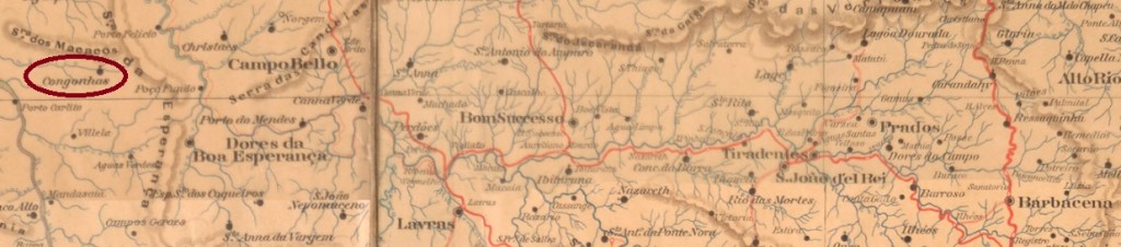
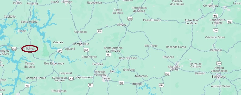
Congonhas da Boa Esperança had been a district of the Vila de Dores da Boa Esperança since November 1875 and was located on the north bank of the Ribeirão Itaci, 350 kilometres west of the provincial capital Ouro Preto. In October 1883, the village was elevated to a freguesia and renamed Ilcínea in September 1923. Ilcínea has been an independent município since December 1953.
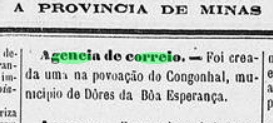
According to the regional press, there has been a post office there since August 1887:
A Provincia de Minas, 19/08/1887
Imperial postmarks from Congonhas da Boa Esperança have not yet been found.
Google Maps
Andere Namen: Ilicínea (1923)
Congonhas da Boa Esperança war seit November 1875 ein Distrikt der Vila de Dores da Boa Esperança und lag am Nordufer des Ribeirão Itaci, 350 km westlich der Provinzhauptstadt Ouro Preto. Im Oktober 1883 wurde der Ort zur Freguesia erhoben und im September 1923 in Ilcínea umbenannt. Seit Dezember 1953 ist Ilcínea ein unabhängiger Município.
Wie aus der regionalen Presse hervorgeht, gab es dort seit August 1887 ein Postamt:
A Provincia de Minas, 19.08.1887
Kaiserliche Poststempel aus Congonhas da Boa Esperança wurden bisher nicht gefunden.
Villiers de l’Ile Adam: Carta (…) da Provincia de Minas Geraes, 1849
Other names: Congonhas das Minas de Ouro, Vila Nova de Lima, Nova Lima (1923)
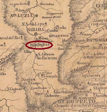
The second village of Congonhas in the province of Minas Gerais had been a freguesia of Vila de Sabará since February 1836, located on the east bank of the Rio das Velhas, 90 kilometres northwest of the provincial capital Ouro Preto. In February 1891, it was renamed Vila Nova de Lima, which has been Município de Nova Lima since September 1923.
As the press in Rio reported, there had been a post office there since December 1864:
Correio Mercantil/RJ, 11/12/1864
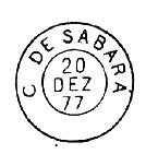
The original oldest postmark here is CMG-0855b, which was previously erroneously assigned to the city (Cidade) of Sabará. It also exists in blue and is illustrated by P. Ayres (Catálogo de Carimbos Brasil-Império, S. Paulo, 1937, 1942):
CMG-0855b (P.A. p. 126) 1877-1892
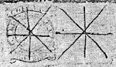
R. Koester (Carimbologia XIV) also shows two mute postmarks from Congonhas de Sabará:
1877ff (RK)1888 (RK)Provincia de Minas Geraes, 1873
Andere Namen: Congonhas das Minas de Ouro, Vila Nova de Lima, Nova Lima (1923)
Die zweite Ortschaft Congonhas in der Provinz Minas Gerais war seit Februar 1836 eine Freguesia der Vila de Sabará, gelegen am Ostufer des Rio das Velhas, 90 km nordwestlich der Provinzhauptstadt Ouro Preto. Im Februar 1891 wurde sie in Vila Nova de Lima umbenannt, die seit September 1923 Município de Nova Lima ist.
Wie die Presse in Rio berichtete, gab es dort seit Dezember 1864 ein Postamt:
Correio Mercantil/RJ, 11.12.1864
Der zunächst älteste Poststempel hier ist CMG-0855b, der früher irrtümlich der Stadt (Cidade) Sabará zugeordnet wurde. Er existiert auch in blau und ist bei P. Ayres (Catálogo de Carimbos Brasil-Império, S. Paulo, 1937, 1942) abgebildet:
CMG-0855b (P.A. S. 126) 1877-1892
Aus Congonhas de Sabará zeigt R. Koester (Carimbologia XIV) zwei stumme Poststempel:
Other names: Congonhas de Mattosinhos, Congonhas (1948)
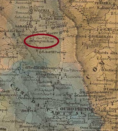
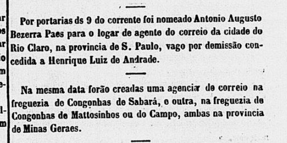
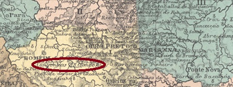
In addition to the Congonhal post office (CMG-0835), there were five post offices in the imperial province of Minas Gerais that bore the name Congonhas. The first among them had been a freguesia since November 1746, which belonged to the capital Vila Rica (later: Ouro Preto) and was located 50 kilometres west of it on the north bank of the Maranhão. In September 1923, it was transferred as a district to the Município de Queluz and in December 1938 became the Município de Congonhas do Campo, which shortened the place name to Congonhas 10 years later.
According to consistent sources, there has been a post office there since December 1864, which is also confirmed by the press in Rio:
Correio Mercantil/RJ, 11/12/1864
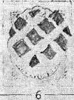
The oldest postmark to date is CMG-0860b (ill. R. Koester in Carimbologia XIV):
CMG-0860b (RK) 1882-1885
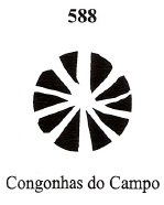
A mute cancellation is also known from there, which was given the no. 588 in Mute Cancellations of the Brazil Empire / Carimbos Mudos do Brasil Império (Brazil Philatelic Association, Rio de Janeiro, 2000) by James Dingler and Klerman W. Lopes:
BPA 588 (1882)Villiers de l’Ile Adam: Carta (…) da provincia de Minas Geraes, 1849
Andere Namen: Congonhas de Mattosinhos, Congonhas (1948)
Neben dem Postamt Congonhal (CMG-0835) gab es in der kaiserlichen Provinz Minas Gerais fünf Postämter, die den Namen Congonhas trugen. Das erste war seit November 1746 eine Freguesia, die zur Hauptstadt Vila Rica gehörte und 50 km westlich von dieser am Nordufer des Maranhão lag. Im September 1923 ging sie als Distrikt an das Município de Queluz über und wurde im Dezember 1938 zum Município de Congonhas do Campo, das 10 Jahre später den Ortsnamen zu Congonhas verkürzte.
Nach übereinstimmenden Quellen gibt es dort seit Dezember 1864 ein Postamt, was auch von der Presse in Rio bestätigt wird:
Correio Mercantil/RJ, 11.12.1864
Der bisher älteste Poststempel ist CMG-0860b (Abb. R. Koester in Carimbologia XIV):
CMG-0860b (RK) 1882-1885
Von dort ist auch ein stummer Stempel bekannt, der in Mute Cancellations of the Brazil Empire / Carimbos Mudos do Brasil Império (Brazil Philatelic Association, Rio de Janeiro, 2000) von James Dingler und Klerman W. Lopes die Nr. 588 erhielt:
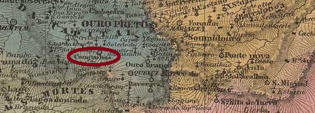
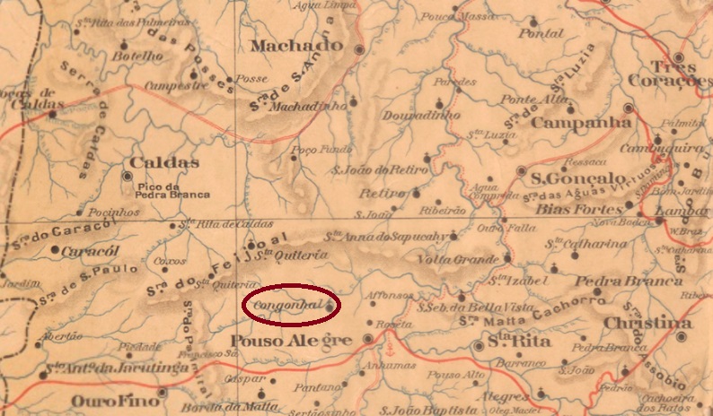
Founded in June 1876, the district of S. José do Congonhal belonged to the Vila de Pouso Alegre and was located on the south bank of the Rio Cervo, 450 kilometres southwest of the provincial capital Ouro Preto. In November 1880, the village was declared a freguesia and in December 1953 a município.
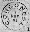
As Paula Sobrinho (História Postal de Minas Gerais, Belo Horizonte, 1997) and R. Koester (Carimbologia XIV) write, there had been a post office there since September 1881. The imperial postmark here is CMG-0835a (fig. R. Koester, op. cit.):
CMG-0835a (RK) 1885-1898Google Maps
Der im Juni 1876 gegründete Distrikt S. José do Congonhal gehörte zur Vila de Pouso Alegre und lag am Südufer des Rio Cervo, 450 km südwestlich der Provinzhauptstadt Ouro Preto. Im November 1880 wurde der Ort zur Freguesia und im Dezember 1953 zum Município erklärt.
Wie Paula Sobrinho (História Postal de Minas Gerais, Belo Horizonte, 1997) und R. Koester (Carimbologia XIV) schreiben, gab es dort seit September 1881 ein Postamt. Der kaiserliche Poststempel davon ist CMG-0835a (Abb. R. Koester, op. cit.):
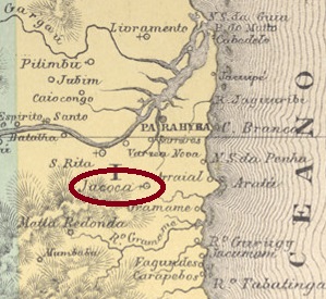
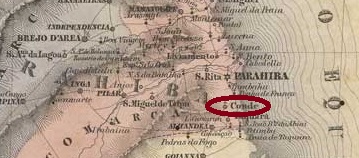
From 1768, Conde was the name of a freguesia of the Vila da Paraíba do Norte, which was located 20 kilometres south of the later provincial capital. It is said to have been elevated to a Vila around 1800, but lost this status in June 1846 and became the Freguesia de Jacoca, named after a Tabajara Indian settlement. In September 1886, it was again elevated to Vila and retained this status until December 1943, when the Distrito de Jacoca was founded in the Município de João Pessoa. The name Vila do Conde returned in January 1949, and since November 1963 the town has been Município de Conde. The Count (Conde) here could have been the Dutch commander Moritz of Nassau, who conquered north-east Brazil at the beginning of the 17th century.
Three foundation dates have been found for the local post office, the last two of which are very close to each other and probably belong together. The first was around October 1829, as reported in the Pernambuco press:
O Cruzeiro/PE, 13/10/1829
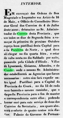
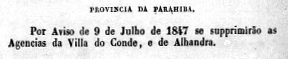
The agency was closed in July 1847, as reported by the Imperial Ministry:
Relatorio do Ministerio do Imperio, 1847
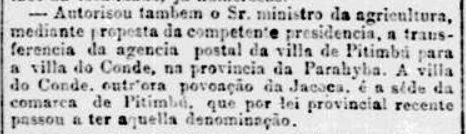
The Conde post office in the province of Paraíba only reopened in January 1887, as reported in the Rio press:
Jornal do Commercio/RJ, 05/01/1887
R. Koester (Carimbologia XIV) gives a date a few days later. No imperial postmark of this conde has yet been found.
Villiers de l’Ile Adam: Carta (…) das Provincias do Rio Grande e Parahiba do Norte
Andere Namen: Jacoca
Conde war ab 1768 der Name einer Freguesia der Vila da Paraíba do Norte, die 20 km südlich der späteren Provinzhauptstadt lag. Sie soll um 1800 zur Vila erhoben worden sein, verlor diesen Status aber im Juni 1846 und wurde zur Freguesia de Jacoca, benannt nach einer Tabajara-Indianersiedlung. Im September 1886 wurde sie erneut zur Vila erhoben und behielt diesen Status bis Dezember 1943, als der Distrito de Jacoca im Município de João Pessoa gegründet wurde. Der Name Vila do Conde kehrte im Januar 1949 zurück, und seit November 1963 ist die Stadt Município de Conde. Der Graf (Conde) hier könnte der niederländische Befehlshaber Moritz von Nassau gewesen sein, der den Nordosten Brasiliens zu Beginn des 17.
Es wurden drei Gründungsdaten für das örtliche Postamt gefunden, wobei die letzten beiden sehr nahe beieinander liegen und wahrscheinlich zusammengehören. Das erste um Oktober 1829, wie die Presse von Pernambuco berichtete:
O Cruzeiro/PE, 13.10.1829
Die Agentur wurde im Juli 1847 geschlossen, wie das kaiserliche Ministerium berichtete:
Relatorio do Ministerio do Imperio, 1847
Das Postamt Conde der Provinz Paraíba öffnete erst wieder im Januar 1887, wie die Presse aus Rio berichtete:
Jornal do Commercio/RJ, 05.01.1887
R. Koester (Carimbologia XIV) gibt dafür ein Datum einige Tage später an. Bisher wurde kein kaiserlicher Poststempel von diesem Conde gefunden.
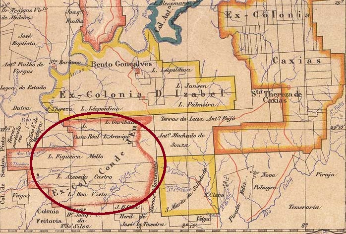
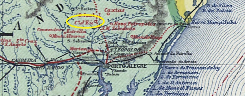
Conde d’Eu in the province of São Pedro do Rio Grande was founded in May 1870 to provide a new home for Italian immigrants 110 kilometres north of the provincial capital Porto Alegre. In April 1884, the colony became the Freguesia de S. Pedro do Conde d’Eu, which belonged to the Vila de S. João do Montenegro. In October 1890, it was incorporated as a district into the newly founded Município de Bento Gonçalves and has been the Município de Garibaldi since October 1900. The name commemorates the Italian freedom fighter Giuseppe Garibaldi (1807-1882), who also played an active role in the Farroupilha Revolution (1835-1845) in southern Brazil.
The local post office was created in 1881, as R. Koester writes in Carimbologia XIV and the provincial president’s report the following year confirms:
Relatorio do Presidente da Provincia, 1882
The oldest postmark to date is CRS-0125a (image from the Internet):
CRS-0125a (EB) 1885-1899
R. Koester (op. cit.) also shows the CRS-0125b postmark:
CRS-0125b (RK)Carta da Republica dos Estados Unidos do Brasil, 1892
Andere Namen: Garibaldi (1900)
Conde d’Eu in der Provinz São Pedro do Rio Grande wurde im Mai 1870 gegründet, um italienischen Einwanderern 110 km nördlich der Provinzhauptstadt Porto Alegre eine neue Heimat zu bieten. Die Kolonie wurde im April 1884 zur Freguesia de S. Pedro do Conde d’Eu, die zur Vila de S. João do Montenegro gehörte. Im Oktober 1890 wurde sie als Distrikt in das neu gegründete Município de Bento Gonçalves eingegliedert und ist seit Oktober 1900 das Município de Garibaldi. Der Name erinnert an den italienischen Freiheitskämpfer Giuseppe Garibaldi (1807-1882), der auch eine aktive Rolle in der Farroupilha-Revolution (1835-1845) im Süden Brasiliens spielte.
Das örtliche Postamt entstand 1881, wie R. Koester in Carimbologia XIV schreibt und der Bericht des Provinzpräsidenten im folgenden Jahr bestätigt:
Relatorio do Presidente da Provincia, 1882
Der bisher älteste Poststempel ist CRS-0125a (Abbildung aus dem Internet):
CRS-0125a (EB) 1885-1899
R. Koester (op. cit.) zeigt auch den Siegelstempel CRS-0125b:
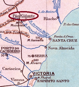
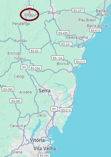
Other names: Núcleo Colonial de Santa Cruz, Bocaiúva, Guaraná, Pau Gigante, Ibiraçu (1943)
The village was founded in 1877 by Italian immigrants as the colony Conde d’Eu, belonged to the Vila de Santa Cruz (today: Aracruz) and was located a good 70 kilometres north of the provincial capital Vitória. It was renamed several times: around 1890 to Bocaiúva (as a district), in September 1891 to Município de Guaraná, in March 1892 to Pau Gigante (made a town in 1938) and finally in December 1943 to Ibiraçu.
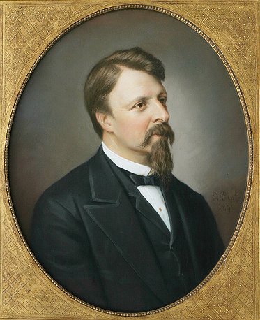
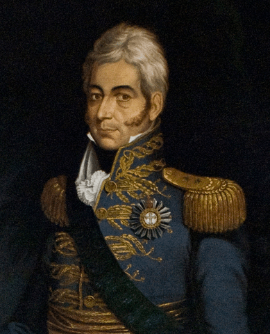
Gaston d’Orléans, Count d’Eu (1842-1922), the son-in-law of Emperor D. Pedro II, was not very popular among the Brazilians.
Conde d’Eu, Portrait by Karl E. Papf (around 1900)
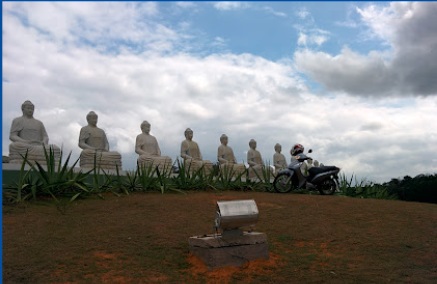
After the end of the empire, the name was changed to Bocaiúva, probably in homage to the republican Quintino Bocaiúva (1836-1912). The strange-sounding name Guaraná was intended to commemorate Aristides Arminio Guaraná (1843-1927), a veteran of the Paraguay War who was appointed chief administrator of the colony. Pau Gigante (Giant Trunk) commemorates a 60 metre high tree nearby that was the symbol of the settlement. And Ibiraçu translates it into the Indian language tupi. Today, a Buddhist monastery is the town’s main attraction.
Photo: Eduardo Lucas (Google Maps)
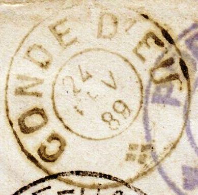
As Paulo Novaes writes in agenciaspostais.com.br, there should be a post office there since July 1885, but it only started operating by 1887. No imperial postmarks from Conde d’Eu have yet been found.
Google Maps
Andere Namen: Núcleo Colonial de Santa Cruz, Bocaiúva, Guaraná, Pau Gigante, Ibiraçu (1943)
Der Ort wurde 1877 von italienischen Einwanderern als Kolonie Conde d’Eu gegründet, gehörte zur Vila de Santa Cruz (heute: Aracruz) und lag gut 70 km nördlich der Provinzhauptstadt Vitória. Es folgten mehrere Umbenennungen: um 1890 in Bocaiúva (als Distrikt), im September 1891 in Município de Guaraná, im März 1892 in Pau Gigante (1938 zur Stadt ernannt) und schließlich im Dezember 1943 in Ibiraçu.
Gaston d’Orléans, Graf d’Eu (1842-1922), war der bei den Brasilianern wenig beliebte Schwiegersohn des Kaisers D. Pedro II.
Der Graf d’Eu, Porträt von Karl E. Papf (um 1900)
Nach dem Ende des Kaiserreichs folgte die Umbenennung in Bocaiúva, wohl eine Hommage an den Republikaner Quintino Bocaiúva (1836-1912). Der seltsam klingende Name Guaraná sollte an Aristides Arminio Guaraná (1843-1927) erinnern, einen Veteranen des Paraguay-Krieges, der zum Hauptverwalter der Kolonie ernannt wurde. Pau Gigante (Riesenstamm) erinnert an einen 60 Meter hohen Baum der Gegend, der als Wahrzeichen der Siedlung galt. Und Ibiraçu heißt es übersetzt in der Indianersprache Tupi. Heute ist ein buddhistisches Kloster die Hauptattraktion des Städtchens.
Foto: Eduardo Lucas (Google Maps)
Wie Paulo Novaes in agenciaspostais.com.br schreibt, soll es dort seit Juli 1885 ein Postamt gegeben haben, das aber erst 1887 seinen Betrieb aufnahm. Bisher wurden keine kaiserlichen Poststempel von Conde d’Eu gefunden.
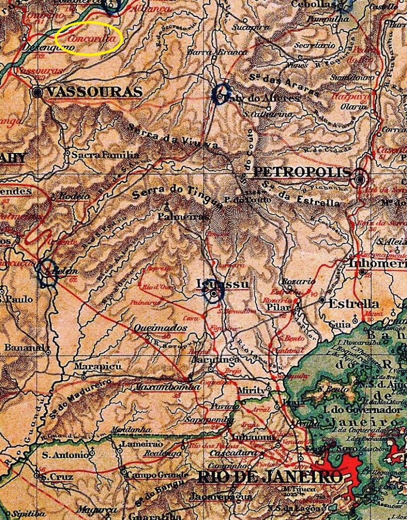
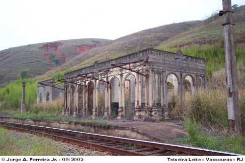
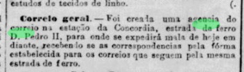
Concordia station was opened in April 1879 by the railway company E.F. D. Pedro II (Central line) on the south bank of the Paraíba do Sul in the Município de Vassouras, 130 km north-west of the capital Rio de Janeiro. The line was transferred to E.F. Central do Brasil in 1889 and belonged to Rede Ferroviária Federal S.A. (estacoesferroviarias.com.br) from 1975 until its closure in 1996. Today the tracks are still there, the station building is a ruin.
2002 (Photo: Jorge A. Ferreira Jr, on estacoesferroviarias.com.br)
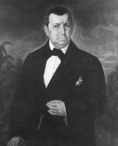
The station was renamed Teixeira Leite around 1925 in honour of Francisco José de Teixeira Leite, Baron of Vassouras, a prominent landowner in the region.
The Barão de Vassouras (Museu Histórico Nacional)
As reported in the Rio press, there was a post office at the railway station from April 1879:
Jornal do Commercio/30/04/1879
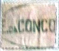
The oldest postmark to date is the rare CRJ-1020a (image from the Internet):
CRJ-1020a (EB) 1880ff
R. Koester showed the CRJ-1020b seal postmark in Carimbologia XIV:
CRJ-1020b (RK)
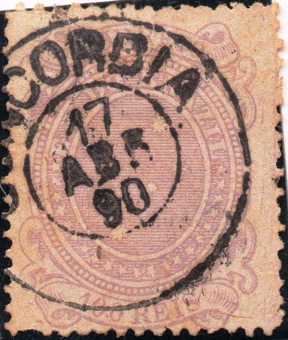
Later the double circle CRJ-1020c also appeared (picture from the internet):
CRJ-1020c (EB) 1883ff-1890Estações (…) do Rio de Janeiro, São Paulo e Minas Geraes, 1880
Andere Namen: Teixeira Leite (ca. 1925)
Der Bahnhof Concordia wurde im April 1879 von der Bahngesellschaft E.F. D. Pedro II (Hauptstrecke) eröffnet und lag am Südufer des Paraíba do Sul im Município de Vassouras, 130 km nordwestlich der Hauptstadt Rio de Janeiro. Die Strecke ging 1889 an die E.F. Central do Brasil über und gehörte von 1975 bis zu ihrer Stilllegung 1996 der Rede Ferroviária Federal S.A. (estacoesferroviarias.com.br). Heute sind die Gleise noch vorhanden, das Bahnhofsgebäude ist eine Ruine.
2002 (Foto: Jorge A. Ferreira Jr, auf estacoesferroviarias.com.br)
Der Bahnhof wurde um 1925 in Teixeira Leite umbenannt, zu Ehren von Francisco José de Teixeira Leite, Baron von Vassouras, einem prominenten Landbesitzer der Region.
Der Barão de Vassouras (Museu Histórico Nacional)
Wie die Presse in Rio berichtete, gab es ab April 1879 ein Postamt am Bahnhof:
Jornal do Commercio/30.04.1879
Der bisher älteste Poststempel ist der seltene CRJ-1020a (Bild aus dem Internet):
CRJ-1020a (EB) 1880ff
R. Koester zeigte den Siegelstempel CRJ-1020b in Carimbologia XIV:
CRJ-1020b (RK)
Später erschien auch der Doppelkreis CRJ-1020c (Bild aus dem Internet):
Villiers de l’Ile Adam: Carta (…) da Provincia da Bahia, 1848
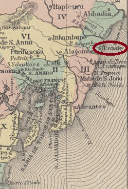
Other names: Itapicuru de Baixo, Itapicuru da Praia, Villa do Conde
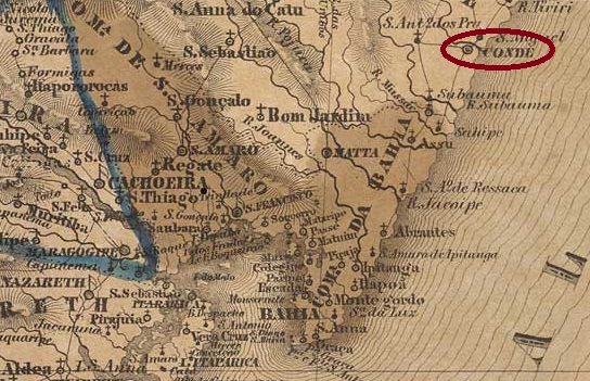
Itapicuru de Baixo was originally the name of the settlement on the south bank of the Itapicuru near its mouth in the Atlantic, 190 kilometres north of the later provincial capital Salvador da Bahia. In 1702 it became the Freguesia de N. Sra. do Monte de Itapicuru da Praia, which was elevated to Vila do Conde in December 1806. This count (Conde) is said to have been the last Brazilian viceroy, D. Marcos de Noronha e Brito (1771-1828), 8th Conde dos Arcos:
The 8th Conde dos Arcos (Wikipedia)
In August 1921, Conde was elevated to the status of a town, but in June 1931 it became a district of the Município de Esplanada. It has been called Município do Conde again since August 1935.
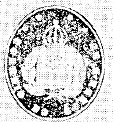
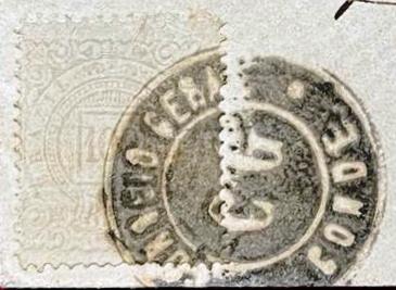
According to consistent sources, there has been a post office since October 1858. The oldest postmark to date is CBA-0310b (coll. Klerman W. Lopes) in a beautiful negative look:
CBA-0310b (KL) 1877ff-1898ff
This was followed by the French type CBA-0310c (fig. Rodrigo Baldassare)
CBA-0310c (RB) 1883-1890
Towards the end of the 19th century, CBA-0310d (illustration from the Internet) was added:
CBA-0310d (EB) 1890Atlas do Imperio do Brasil, 1868
Andere Namen: Itapicuru de Baixo, Itapicuru da Praia, Villa do Conde
Itapicuru de Baixo war ursprünglich der Name der Siedlung am Südufer des Itapicuru nahe seiner Mündung in den Atlantik, 190 km nördlich der späteren Provinzhauptstadt Salvador da Bahia. 1702 wurde daraus die Freguesia de N. Sra. do Monte de Itapicuru da Praia, die im Dezember 1806 zur Vila do Conde erhoben wurde. Dieser Graf (Conde) soll der letzte brasilianische Vizekönig, D. Marcos de Noronha e Brito (1771-1828), 8. Conde dos Arcos, gewesen sein:
Der 8. Conde dos Arcos (Abb. Wikipedia)
Im August 1921 folgte die Erhebung zur Stadt, doch im Juni 1931 wurde Conde ein Distrikt des Município de Esplanada. Seit August 1935 heißt es wieder Município do Conde.
Nach übereinstimmenden Quellen gab es dort seit Oktober 1858 ein Postamt. Der bisher älteste Poststempel ist CBA-0310b (Samml. Klerman W. Lopes) im schönen Negativ-Look:
CBA-0310b (KL) 1877ff-1898ff
Es folgte der französische Typ CBA-0310c (Abb. Rodrigo Baldassare)
CBA-0310c (RB) 1883-1890
Gegen Ende des 19. Jahrhunderts kam CBA-0310d (Abb. aus dem Internet) hinzu:
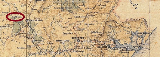
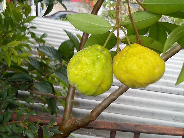
The Freguesia de S. Sebastião das Conchas was founded in March 1872, belonged to the Vila de Ponta Grossa and was located on the east bank of the Tibagi, 140 kilometres west of the provincial capital Curitiba. In March 1881, it was elevated to the status of Vila and retained this status until December 1931, when it was downgraded to a district again. Since December 1943, the district has been called Uvaia. This is the sour fruit of a plant from the myrtle family:
Uvaia (Photo: Divinomar Severino, Wikipedia)
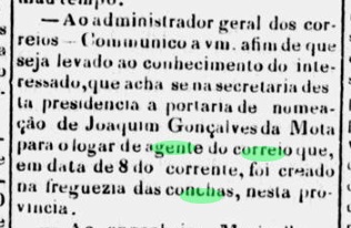
There had been a post office here since April 1874, as can be seen from the regional press:
Dezenove de Dezembro, 13/05/1874
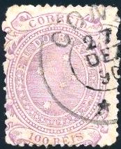
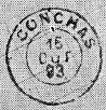
The imperial postmark is CPR-0060a (illustration by R. Koester in Carimbologia XIII):
CPR-0060a (RK) 1878-1897Provincia do Paraná, 1881
Andere Namen: Uvaia (1943)
Die Freguesia de S. Sebastião das Conchas wurde im März 1872 gegründet, gehörte zur Vila de Ponta Grossa und lag am Ostufer des Tibagi, 140 km westlich der Provinzhauptstadt Curitiba. Im März 1881 wurde es zur Vila erhoben und behielt diesen Status bis Dezember 1931, als es wieder zum Distrikt herabgestuft wurde. Seit Dezember 1943 heißt der Distrikt Uvaia. Das ist die saure Frucht einer Pflanze aus der Familie der Myrtengewächse:
Uvaia (Foto: Divinomar Severino, Wikipedia)
Seit April 1874 gab es hier ein Postamt, wie aus der regionalen Presse hervorgeht:
Dezenove de Dezembro, 13.05.1874
Der kaiserliche Poststempel ist CPR-0060a (Abb. R. Koester in Carimbologia XIII):