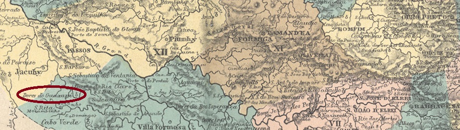
N. Sra. das Dores do Guaxupé was a distrito in the Município de Jacuí from May 1853, located on the south bank of the Guaxupé, 490 km west of the provincial capital Ouro Preto. The village was elevated to a freguesia in July 1864 and as such was incorporated into the Vila de Muzambinho in December 1878. Since August 1911, Guaxupé (as it is now abbreviated) has been an independent município. The name comes from the Tupi language and means bee that nests in the ground.
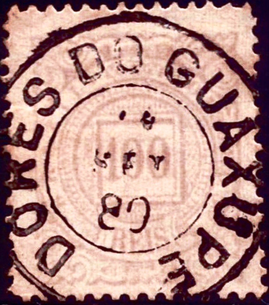
Paula Sobrinho (História Postal de Minas Gerais, Belo Horizonte, 1997) and R. Koester (Carimbologia XVI) agree that there has been a post office there since November 1878. The only imperial postmark to date is DMG-1065a (fig. Claudio Coelho):
DMG-1065a (CC) 1883-1908Carta da Republica dos Estados Unidos do Brazil, 1892
Andere Namen: Guaxupé (1923)
N. Sra. das Dores do Guaxupé war seit Mai 1853 ein Distrito im Município de Jacuí und lag am Südufer des Guaxupé, 490 km westlich der Provinzhauptstadt Ouro Preto. Der Ort wurde im Juli 1864 zur Freguesia erhoben und als solche im Dezember 1878 in die Vila de Muzambinho eingegliedert. Seit August 1911 ist Guaxupé (wie es jetzt abgekürzt wird) ein eigenständiges Município. Der Name stammt aus der Tupi-Sprache und bedeutet Biene, die in der Erde nistet.
Paula Sobrinho (História Postal de Minas Gerais, Belo Horizonte, 1997) und R. Koester (Carimbologia XVI) sind sich einig, dass es dort seit November 1878 ein Postamt gab. Der bisher einzige kaiserliche Poststempel ist DMG-1065a (Abb. Claudio Coelho):
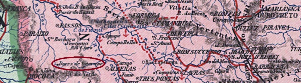
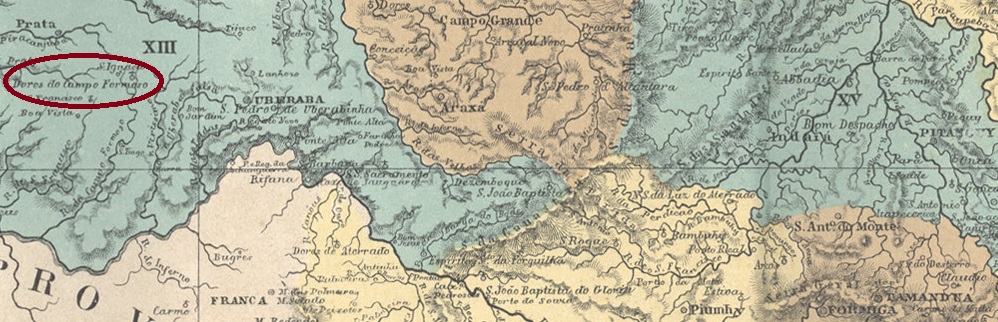
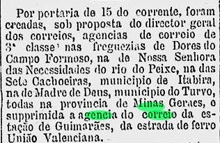
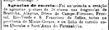
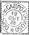
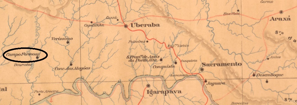
N. Sra. das Dores do Campo Formoso had been a distrito of the Vila de Uberaba since March 1846 and was located on the west bank of the Ribeirão Dourado, 740 kilometres west of the provincial capital Ouro Preto. The village was elevated to a freguesia in November 1875 and renamed Campo Formoso in September 1923. Under this name, it was elevated to Município in December 1938. In December 1943, however, the place name was changed to Campo Florido (Flower Meadow), probably to avoid confusion with the município of the same name in Bahia.
Three dates close to each other were found for the creation of the local post office. The first time was in December 1881, according to the press in Rio:
Gazeta de Noticias/RJ, 18/12/1881
Then again in January 1882, as also reported from Rio:
Jornal do Commercio/RJ 11 Jan. 1882
Finally, both Paula Sobrinho (História Postal de Minas Gerais, Belo Horizonte, 1997) and R. Koester (Carimbologia XVI) have registered February 1882 for it. The only imperial postmark to date is DMG-1060a (fig. Koester, op. cit.):
DMG-1060a (RK) 1887-1890Estado de Minas Geraes, 1910
Andere Namen: Campo Formoso, Campo Florido (1943)
N. Sra. das Dores do Campo Formoso war seit März 1846 ein Distrito der Vila de Uberaba und lag am Westufer des Ribeirão Dourado, 740 km westlich der Provinzhauptstadt Ouro Preto. Der Ort wurde im November 1875 zur Freguesia erhoben und im September 1923 in Campo Formoso umbenannt. Unter diesem Namen erfolgte im Dezember 1938 die Erhebung zum Município. Im Dezember 1943 wurde der Ortsname jedoch in Campo Florido (Blumenwiese) geändert, wahrscheinlich um Verwechslungen mit dem gleichnamigen Município in Bahia zu vermeiden.
Für die Gründung des örtlichen Postamtes wurden drei Daten gefunden, die nahe beieinander liegen. Zum ersten Mal im Dezember 1881, wie aus der Presse in Rio hervorgeht:
Gazeta de Noticias/RJ, 18.12.1881
Dann wieder im Januar 1882, wie ebenfalls aus Rio berichtet wird:
Jornal do Commercio/RJ 11.01.1882
Schließlich haben sowohl Paula Sobrinho (História Postal de Minas Gerais, Belo Horizonte, 1997) als auch R. Koester (Carimbologia XVI) den Februar 1882 dafür registriert. Der bisher einzige kaiserliche Poststempel ist DMG-1060a (Abb. Koester, op. cit.):
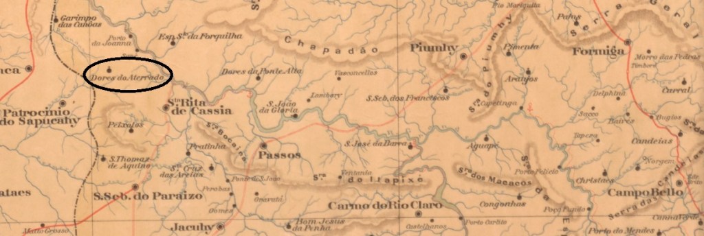
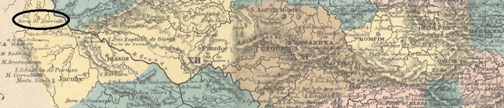
The Freguesia de N. Sra. das Dores do Aterrado was founded in June 1850 and belonged to the Vila de Jacuí, 530 kilometres west of the provincial capital Ouro Preto. In September 1870 it was incorporated into the newly founded Vila S. Sebastião do Paraíso and twenty years later into the Vila de Sta. Rita de Cássia. In September 1923 it was elevated to the Município de Ibiraci, which became a town two years later. The name is of Indian origin and means mother of trees.
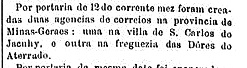
As Paula Sobrinho (História Postal de Minas Gerais, Belo Horizonte, 1997) and R. Koester (Carimbologia XVI) write, there has been a post office there since September 1883. This is confirmed by the press in Rio:
Brazil/RJ, 20/09/1883
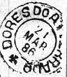
The only imperial postmark to date is DMG-1055a (fig. R. Koester, op. cit.):
DMG-1055a (RK) 1886Atlas do Imperio do Brasil, 1868
Andere Namen: Ibiraci (1923)
Die Freguesia de N. Sra. das Dores do Aterrado wurde im Juni 1850 gegründet und gehörte zur Vila de Jacuí, 530 km westlich der Provinzhauptstadt Ouro Preto. Im September 1870 kam es zur neu gegründeten Vila S. Sebastião do Paraíso und zwanzig Jahre später zur Vila de Sta. Rita de Cássia. Im September 1923 erfolgte die Erhebung zum Município de Ibiraci, das zwei Jahre später zur Stadt wurde. Der Name ist indianischen Ursprungs und bedeutet Mutter der Bäume.
Wie Paula Sobrinho (História Postal de Minas Gerais, Belo Horizonte, 1997) und R. Koester (Carimbologia XVI) schreiben, gab es dort seit September 1883 ein Postamt. Dies wird von der Presse in Rio bestätigt:
BrazillRJ, 20.09.1883
Der bisher einzige kaiserliche Poststempel ist DMG-1055a (Abb. R. Koester, op. cit.):
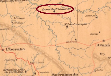
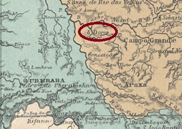
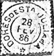
Nossa Senhora das Dores de Santa Juliana had been a district of the Vila de Araxá since October 1851, near the south bank of the Ribeirão Santa Juliana, 600 kilometres west of the provincial capital Ouro Preto. The village was elevated to a freguesia in November 1875 and has been Município de Santa Juliana since December 1938.
Paula Sobrinho (História Postal de Minas Gerais, Belo Horizonte, 1997) and R. Koester (Carimbologia XVI) agree that there has been a post office there since July 1884. The only imperial postmark to date is DMG-1050a (fig. R. Koester, op. cit.):
DMG-1050a (RK) 1886-1889ffAtlas do Imperio do Brasil, 1868
Andere Namen: Santa Juliana (1938)
Nossa Senhora das Dores de Santa Juliana war seit Oktober 1851 ein Distrito der Vila de Araxá, nahe dem Südufer des Ribeirão Santa Juliana, 600 km westlich der Provinzhauptstadt Ouro Preto. Die Ortschaft wurde im November 1875 zur Freguesia erhoben und ist seit Dezember 1938 Município de Santa Juliana.
Paula Sobrinho (História Postal de Minas Gerais, Belo Horizonte, 1997) und R. Koester (Carimbologia XVI) schreiben übereinstimmend, dass es dort seit Juli 1884 ein Postamt gab. Der bisher einzige kaiserliche Poststempel ist DMG-1050a (Abb. R. Koester, op. cit.):
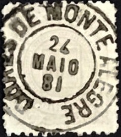
Dores de Monte Alegre was a district of the Vila de Mar d’Espanha from June 1858, located 230 kilometres south of the provincial capital Ouro Preto. In July 1868 the district changed to the Vila de S. João Nepomuceno and in July 1872 Dores de Monte Alegre became a freguesia in the Município Rio Novo, which returned to S. João Nepomuceno in November 1880 and was renamed Taruassú in 1892. The Indian word means “big sky”.
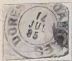
Paula Sobrinho in História Postal de Minas Gerais (Belo Horizonte, 1997) and R. Koester in Carimbologia XVI write that there has been a post office there since September 1878. The oldest postmark to date is DMG-1045a (image from the Internet):
DMG-1045a (EB) 1881-1890
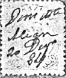
R. Koester (op. cit.) also shows a handwritten cancellation from 1884:
1884 (RK)Atlas do Imperio do Brasil, 1868
Andere Namen: Rabicho, Taruaçu (1892)
Dores de Monte Alegre war ab Juni 1858 ein Distrito der Vila de Mar d’Espanha und lag 230 km südlich der Provinzhauptstadt Ouro Preto. Im Juli 1868 wechselte der Distrikt zur Vila de S. João Nepomuceno und im Juli 1872 wurde Dores de Monte Alegre eine Freguesia im Município Rio Novo, die im November 1880 wieder zu S. João Nepomuceno zurückkehrte und 1892 in Taruassú umbenannt wurde. Das indianische Wort bedeutet “Großer Himmel”.
Paula Sobrinho in História Postal de Minas Gerais (Belo Horizonte, 1997) und R. Koester in Carimbologia XVI schreiben, dass es dort seit September 1878 ein Postamt gab. Der bisher älteste Poststempel ist DMG-1045a (Abbildung aus dem Internet):
DMG-1045a (EB) 1881-1890
R. Koester (op. cit.) zeigt auch eine handschriftliche Entwertung aus dem Jahr 1884:
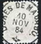
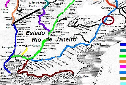
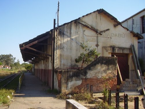
Dores de Macabu station was opened in 1875 by the railway company E.F. Macaé e Campos (Coastline) and was located near the north bank of the Macabu in the Município de Campos, 320 km north-east of the capital Rio de Janeiro. The line went to E.F. Leopoldina in 1887 and belonged to Rede Ferroviária Federal S.A. from 1975 until it was closed in 1996 (estacoesferroviarias.com.br). The tracks are still there today, but the station building was derelict in 2008.
In July 2008 (photo Ricardo Q. Mattos, on estacoesferroviarias.com.br)
As the capital’s press reported, there had been a post office in the station since December 1875:
O Globo, 17/12/1875
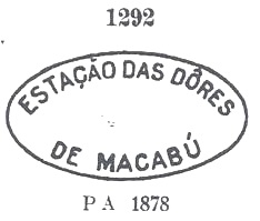
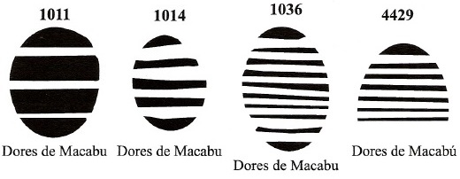
The oldest postmark is DRJ-0455a and was already presented by Paulo Ayres in the Catálogo de Carimbos Brasil-Império (S. Paulo, 1937, 1942) with no. 1292:
DRJ-0455a (P.A. 1292) 1876ff-1878
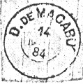
DRJ-0455b (fig. R. Koester in Brasil Filatélico 170) and DRJ-0455c (fig. from the internet) followed almost simultaneously:
DRJ-0455b (RK) 1884DRJ-0455c (EB) 1884
James Dingler and Klerman W. Lopes have also shown four mute cancellations from the Dores de Macabu station in Mute Cancellations of the Brazil Empire / Carimbos Mudos do Brasil Império (Brazil Philatelic Association, Rio de Janeiro, 2000):
Der Bahnhof Dores de Macabu wurde 1875 von der Bahngesellschaft E.F. Macaé e Campos (Küstenlinie) eröffnet und lag nah am Nordufer des Macabu im Município de Campos, 320 km nordöstlich der Hauptstadt Rio de Janeiro. Die Strecke ging 1887 an die E.F. Leopoldina und gehörte von 1975 bis zu ihrer Stilllegung 1996 der Rede Ferroviária Federal S.A. (estacoesferroviarias.com.br). Heute sind die Gleise noch vorhanden, das Bahnhofsgebäude war 2008 noch verfallen.
Im Juli 2008 (Foto Ricardo Q. Mattos, auf estacoesferroviarias.com.br)
Wie die Hauptstadtpresse berichtete, gab es im Bahnhof seit Dezember 1875 ein Postamt:
O Globo, 17.12.1875
Der älteste Poststempel ist DRJ-0455a und wurde bereits von Paulo Ayres im Catálogo de Carimbos Brasil-Império (S. Paulo, 1937, 1942) mit Nr. 1292 vorgestellt:
DRJ-0455a (P.A. 1292) 1876ff-1878
Fast gleichzeitig folgten DRJ-0455b (Abb. R. Koester in Brasil Filatélico 170) und DRJ-0455c (Abb. aus dem Internet):
DRJ-0455b (RK) 1884DRJ-0455c (EB) 1884
James Dingler und Klerman W. Lopes haben in Mute Cancellations of the Brazil Empire / Carimbos Mudos do Brasil Império (Brazil Philatelic Association, Rio de Janeiro, 2000) auch vier stumme Stempel aus dem Bahnhof Dores de Macabu abgebildet:
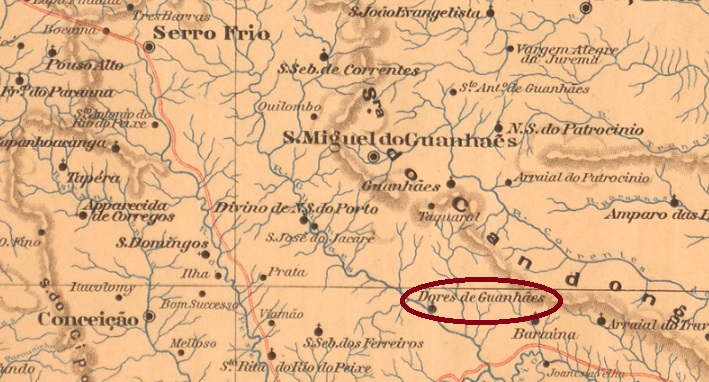
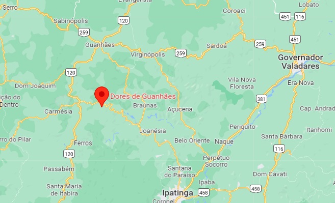
The locality of Capellinha das Dores became a district in April 1854, belonged to the Vila of Conceição do Mato Dentro and was located on the south bank of the Guanhães, 260 km north of the provincial capital of Ouro Preto. In September 1870, it was elevated to a freguesia and assigned to the Vila of S. Miguel de Guanhães under the name N. Sra. das Dores. In September 1923, the place name was simplified to Dores de Guanhães, which has been an independent município since December 1962.
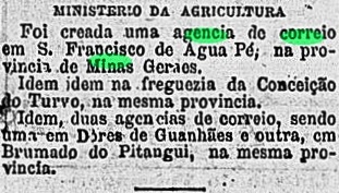
Of the three creation dates for the local post office, one is probably wrong, the other two possibly belong together. In the Directory of Imperial Post Offices (Tabella das Agencias do Correio do Imperio, Rio de Janeiro, 1885) the year 1862 is given, but this is more likely a case of confusion with the other Capellinha in Minas Gerais (CMG-0555), where a post office was founded in that year. Both Paula Sobrinho in História Postal de Minas Gerais (Belo Horizonte, 1997) and R. Koester in Carimbologia IX write February 1881 for the creation of the post office in Dores de Guanhães, which is confirmed by the press in Rio:
Gazeta de Noticias/RJ, 21/02/1881
In November of the same year, the capital’s press reported on the establishment of a post office in Capellinha das Dores:
Jornal do Commercio/RJ, 12.11.1881
No imperial postmark with Capellinha das Dores has yet been found. With the place name Dores de Guanhães there is DMG-1040a (illustration from the Internet), which also occurs in dark violet:
DMG-1040a (EB) 1885-1889Google Maps
Siehe auch Capellinha das Dores (CMG-0565)
Die Siedlung Capellinha das Dores wurde ein Distrikt im April 1854, gehörte zur Vila von Conceição do Mato Dentro und lag am Südufer des Guanhães, 260 km nördlich der Provinzhauptstadt Ouro Preto. Im September 1870 wurde es zur Freguesia erhoben und unter dem Namen N. Sra. das Dores der Vila von S. Miguel de Guanhães zugeordnet. Im September 1923 wurde der Ortsname in Dores de Guanhães vereinfacht, der Ort ist seit Dezember 1962 ein eigenständiges Município.
Von den drei gefundenen Gründungsdaten für das örtliche Postamt dürfte das älteste falsch sein, die beiden anderen gehören möglicherweise zusammen. Im Verzeichnis der kaiserlichen Postämter (Tabella das Agencias do Correio do Imperio, Rio de Janeiro, 1885) wird das Jahr 1862 angegeben, aber hier liegt eher eine Verwechslung mit dem anderen Capellinha in Minas Gerais (CMG-0555) vor, wo in diesem Jahr ein Postamt gegründet wurde. Paula Sobrinho in História Postal de Minas Gerais (Belo Horizonte, 1997) und R. Koester in Carimbologia IX schreiben den Februar 1881 für die Postamtgründung in Dores de Guanhães, was durch die Presse in Rio bestätigt wird:
Gazeta de Noticias/RJ, 21.02.1881
Die Hauptstadtpresse berichtete im November desselben Jahres von einer Postamtsgründung in Capellinha das Dores:
Jornal do Commercio/RJ, 12.11.1881
Bisher wurde noch kein kaiserlicher Poststempel aus diesem Ort unter Capellinha das Dores gefunden. Mit dem Ortsnamen Dores de Guanhães haben wir DMG-1040a (Abb. aus dem Internet), der auch in dunkelviolett vorkommt:
Other names: Vila Vasconcelos, Sentinela do Sul (1992)
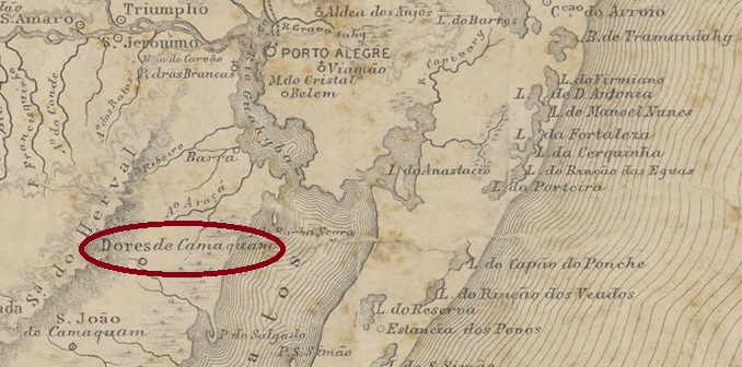
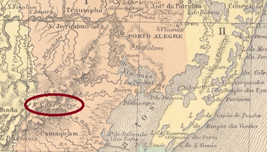
The chapel of N. Sra. das Dores was built in 1819. It was located on the east bank of the Sanga das Capivaras and belonged to the capital of Capitania, Porto Alegre, 100 kilometres to the north. In October 1831, it was incorporated as a district of the newly founded Vila de Triunfo. This was followed by no fewer than four promotions to freguesia: in August 1833 (to Triunfo), in April 1846 and December 1851 (under Porto Alegre) and in April 1864 (belonging to Vila de S. João Do Camaquan). In between, Dores do Camaquan was twice an independent vila, in December 1857 and April 1875.
The administrative chages continued in the 20th centur. In January 1911, Dores do Camaquan became a district of the Município de Porto Alegre, in January 1929 this district was transferred to the Município de Tapes and in November 1938 the place name was changed to Vila Vasconcelos. Since March 1992, the locality has been the Município Sentinela do Sul.
Nova Monteiro (Administrações e Agencias Postaes do Brasil Imperio, in Brasil Filatelico/RJ, 1934-5; reprint SPP 1994-1999) and R. Koester (Carimbologia XVI) write that there was a post office there from October 1860. The oldest postmark to date is probably not the first. DRS-0155b (fig. André Matzenbacher und Claudio Coelho) was previously seen with dates from 1880-1901:
DRS-0155b (AM-CC) 1880-1901
R . Koester (op. cit.) also shows the seal postmark DRS-0155c:
DRS-0155c (RK XVI)Atlas do Imperio do Brasil, 1868
Andere Namen: Vila Vasconcelos, Sentinela do Sul (1992)
Die Kapelle N. Sra. das Dores wurde 1819 erbaut. Sie lag am Ostufer des Kleinflusses Sanga das Capivaras und gehörte zur 100 km nördlich gelegenen Hauptstadt der Capitania, Porto Alegre. Im Oktober 1831 wurde es als Distrito der neu gegründeten Vila de Triunfo eingegliedert. Es folgten nicht weniger als vier Aufstiege zur Freguesia: im August 1833 (zu Triunfo), im April 1846 und im Dezember 1851 (zu Porto Alegre) und im April 1864 (zu Vila de S. João Do Camaquan). Dazwischen war Dores do Camaquan zweimal eine unabhängige Vila, im Dezember 1857 und im April 1875.
Im 20. Jahrhundert ging die wechselvolle Geschichte der Gemeindeverwaltung munter weiter: Im Januar 1911 wurde Dores do Camaquan ein Distrito des Município de Porto Alegre, im Januar 1929 ging dieser Distrikt an das Município de Tapes über und im November 1938 wurde der Ortsname in Vila Vasconcelos geändert. Seit März 1992 ist der Ort der Município Sentinela do Sul.
Nova Monteiro (Administrações e Agencias Postaes do Brasil Imperio, in Brasil Filatelico/RJ, 1934-5; Reprint SPP 1994-1999) und R. Koester (Carimbologia XVI) schreiben, dass es dort ab Oktober 1860 ein Postamt gab. Der bisher älteste Poststempel ist wahrscheinlich nicht der erste. DRS-0155b (Abb. André Matzenbacher und Claudio Coelho) wurde bisher mit Daten von 1880-1901 gesehen:
DRS-0155b (AM-CC) 1880-1901
R . Koester (op. cit.) zeigt auch den Siegelstempel DRS-0155c:
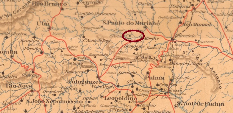
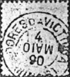
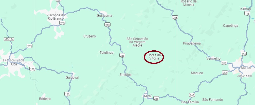
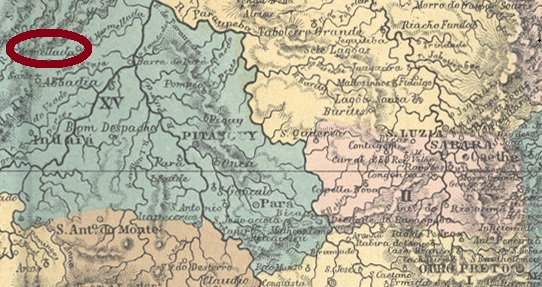
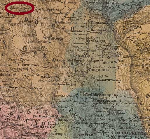
The place was originally called Samambaia (Fern) and since July 1857 was a Distrito of the Vila de S. Paulo do Muriaé on the south bank of the Muriaé, 200 km south-east of the provincial capital Ouro Preto. In September 1874, it was elevated to the status of Freguesia de N. Sra. das Dores da Victoria. Since September 1923, Dores da Vitória (in its current spelling) has been a Distrito in the Município Miraí.
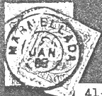
Both R. Koester (Carimbologia XVI) and Paula Sobrinho (História Postal de Minas Gerais, Belo Horizonte, 1997) write that there has been a post office there since December 1887. The oldest postmark to date is DMG-1035a (fig. R. Koester, op. cit.):
DMG-1035a (RK) 1890Google Maps
Andere Namen: Samambaia, Victoria
Der Ort hieß ursprünglich Samambaia (Farn) und war seit Juli 1857 ein Distrito der Vila de S. Paulo do Muriaé am Südufer des Muriaé, 200 km südöstlich der Provinzhauptstadt Ouro Preto. Im September 1874 erfolgte die Erhebung zur Freguesia de N. Sra. das Dores da Victoria. Seit September 1923 ist Dores da Vitória (in der heutigen Schreibweise) ein Distrito im Município Miraí.
Sowohl R. Koester (Carimbologia XVI) als auch Paula Sobrinho (História Postal de Minas Gerais, Belo Horizonte, 1997) schreiben, dass es dort seit Dezember 1887 ein Postamt gab. Der bisher älteste Poststempel ist DMG-1035a (Abb. R. Koester, op. cit.):
In the Tupi-guarani language, Abaeté means strong and brave man. This was also Indian tribe name that originally inhabited this area on the north bank of the Marmelada River, 300 km northwest of the provincial capital Ouro Preto. In July 1864, the settlement became the Freguesia of Nossa Senhora do Patrocínio da Marmellada, in the Município of Dores do Indayá. When in September 1870 Dores do Indayá was downgraded to a district of Pitangui, Patrocínio da Marmellada was given the status of a villa, and since November 1877 it has been the town of Abaeté.
As Paula Sobrinho writes in História Postal de MInas Gerais (Belo Horizonte, 1997), there was a post office there since June 1873, a year confirmed by the Directory of Imperial Post Offices (Tabella das Agencias do Correio do Imperio, Rio de Janeiro, 1885). So far no postmark with DORES DA MARMELLADA has been seen, but Koester (Carimbologia XVI and XXVII) shows the MARMELLADA postmark MMG-3390a:
MMG-3390a (RK) 1884-1886
From 1887 local postmarks show ABAETÉ (see AMG-0005).
Villiers de l’Ile Adam: Carta (…) da Provincia de Minas Geraes, 1849
Andere Namen: Patrocínio da Marmellada, Abaeté
Veja também Abaeté (AMG-0005)
In der Tupi-guarani-Sprache bedeutet Abaeté starker und tapferer Mann. So hieß auch der Indianerstamm, der ursprünglich diese Gegend am Nordufer des Flusses Marmelada bewohnte, 300 km nordwestlich der Provinzhauptstadt Ouro Preto entfernt. Im Juli 1864 wurde aus der Siedlung die Freguesia von Nossa Senhora do Patrocínio da Marmellada, im Município von Dores do Indayá. Als im September 1870 Dores do Indayá zu einem Distrikt von Pitangui herabgesetzt wurde, bekam Patrocínio da Marmellada den Status einer Villa, die seit November 1877 die Stadt Abaeté heißt.
Wie Paula Sobrinho in História Postal de MInas Gerais (Belo Horizonte, 1997) schreibt, gab es dort ein Postamt seit Juni 1873. Das Jahr wird durch das Verzeichnis der kaiserlichen Postämter (Tabella das Agencias do Correio do Imperio, Rio de Janeiro, 1885) bestätigt. Bisher wurde kein Poststempel mit DORES DA MARMELLADA gesehen, aber Koester (Carimbologia XVI und XXVII) zeigt den MARMELLADA-Stempel MMG-3390a:
MMG-3390a (RK) 1884-1886
Ab 1887 kam der Poststempel mit ABAETÉ (s. AMG-0005).