Categories
Carimbologia C-D

Dôres da Boa Esperança, Minas Gerais (DMG-1020)

Atlas do Imperio do Brasil, 1868

Other names: Boa Esperança (1938)

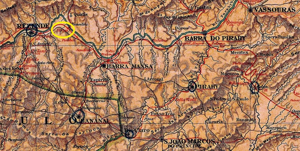
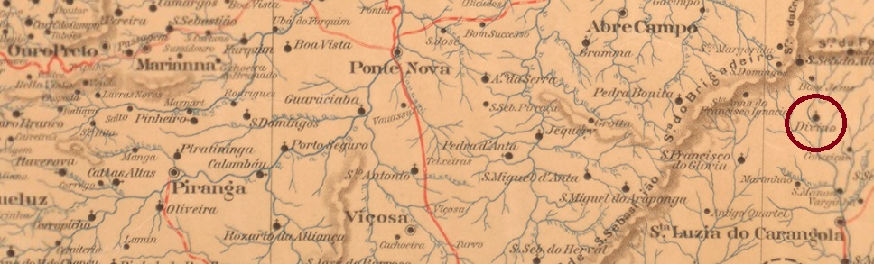
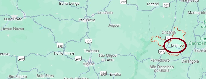
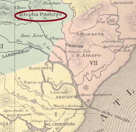
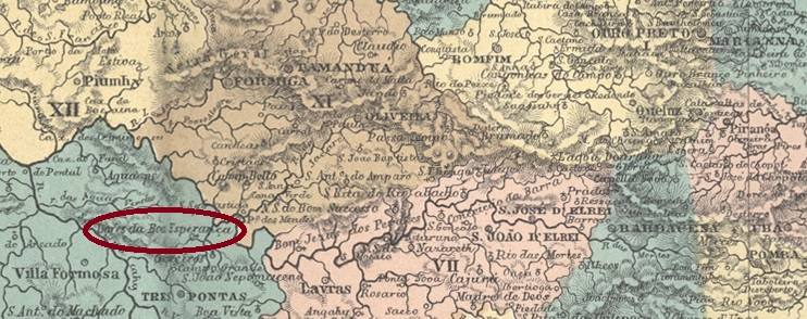
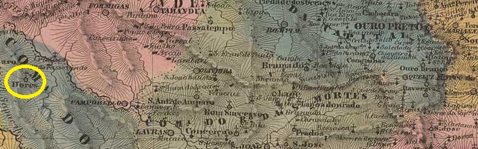
The Freguesia de N. Sra. das Dores da Boa Esperança was founded in June 1813 by royal decree (Alvará Real) and belonged to the Vila de Três Pontas on the south bank of the Rio Grande, 320 kilometres west of the provincial capital Ouro Preto. In November 1866, it was elevated to a Vila and in October 1869 to a town, which has borne the shortened name Boa Esperança since December 1938.

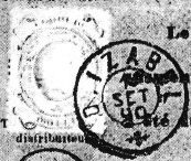
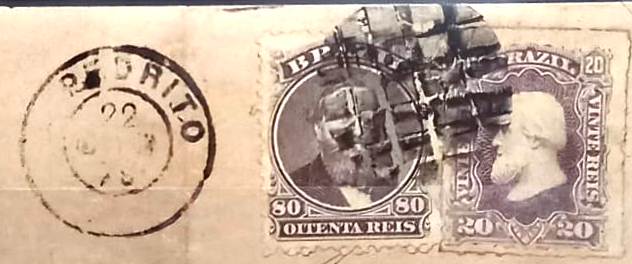
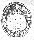
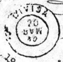
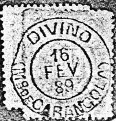
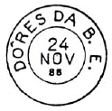
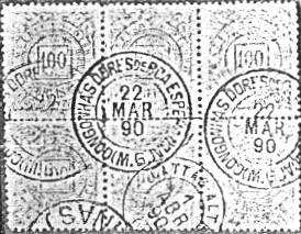
According to consistent sources, there has been a post office since July 1867. The oldest postmark to date is DMG-1020a, illustrated in Paulo Ayres’ Catálogo de Carimbos Brasil-Império (S. Paulo, 1937, 1942) on page 121:

DMG-1020a (P.A. p. 121) 1883

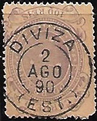
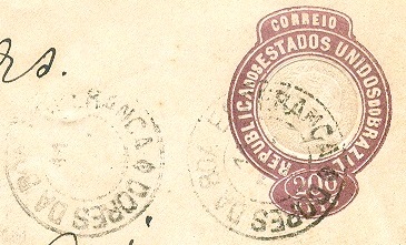
It was followed by DMG-1020b (ill. R. Koester, in Carimbologia XVI):

DMG-1020b (RK) 1890

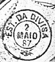
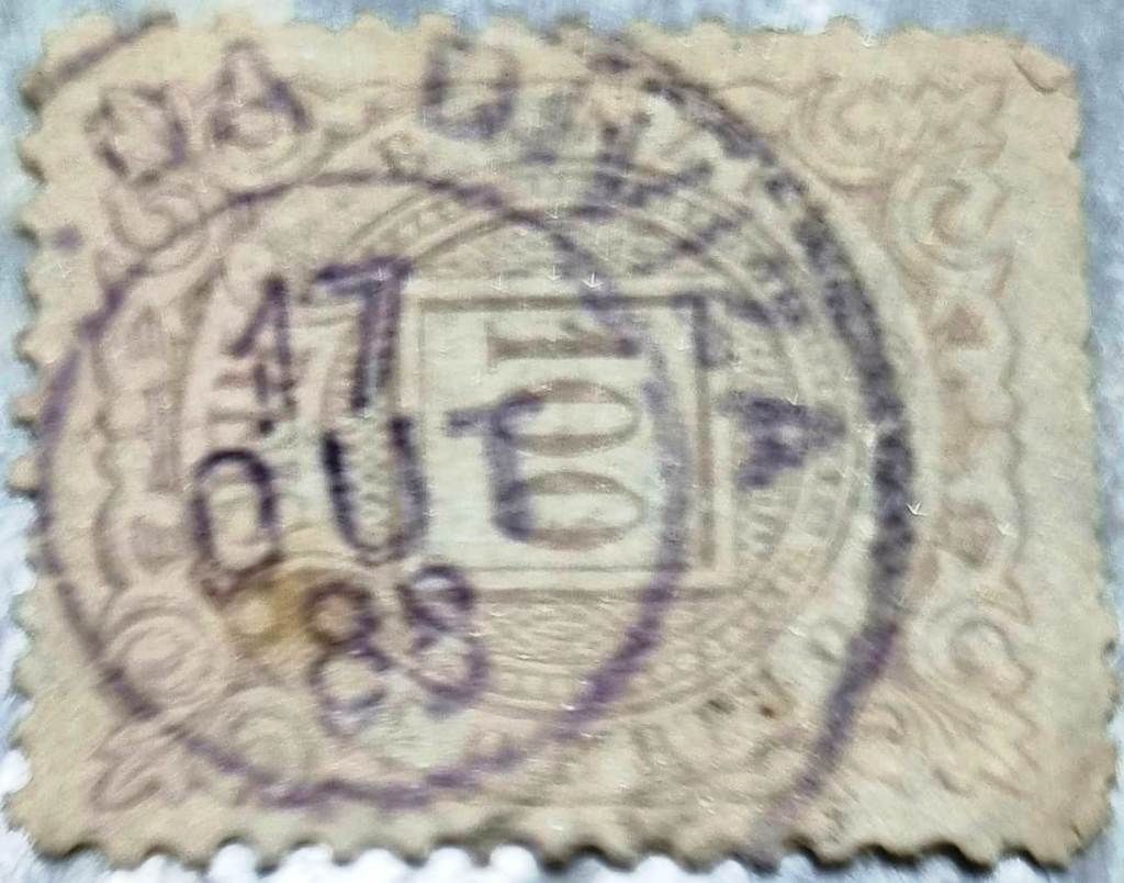
DMG-1020c (ill. Luiz C. Fritzen) was also used at about the same time:

DMG-1020c (LCF) 1890-1892ff

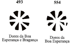
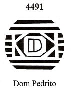
James Dingler and Klerman W. Lopes have shown two mute cancellations of Dores da Boa Esperança in Mute Cancellations of the Brazil Empire / Carimbos Mudos do Brasil Império (Brazil Philatelic Association, Rio de Janeiro, 2000):

BPA 493 (1882) – BPA 554 (P.A. 50, 1883ff)
Villiers de l’Ile Adam: Carta (…) da Provincia de Minas Geraes, 1849

Andere Namen: Boa Esperança (1938)

Die Freguesia de N. Sra. das Dores da Boa Esperança wurde im Juni 1813 durch königliches Dekret (Alvará Real) gegründet und gehörte zur Vila de Três Pontas am Südufer des Rio Grande, 320 km westlich der Provinzhauptstadt Ouro Preto. Im November 1866 wurde es zur Vila und im Oktober 1869 zur Stadt erhoben, die seit Dezember 1938 den verkürzten Namen Boa Esperança trägt.

Nach übereinstimmenden Quellen gab es ein Postamt seit Juli 1867. Der bisher älteste Poststempel ist DMG-1020a, abgebildet in Paulo Ayres‘ Catálogo de Carimbos Brasil-Império (S. Paulo, 1937, 1942) auf Seite 121:

DMG-1020a (P.A. S. 121) 1883

Ihm folgte DMG-1020b (Abb. R. Koester, in Carimbologia XVI):

DMG-1020b (RK) 1890

Etwa zur gleichen Zeit wurde auch DMG-1020c (Abb. Luiz C. Fritzen) verwendet:

DMG-1020c (LCF) 1890-1892ff

James Dingler und Klerman W. Lopes haben in Mute Cancellations of the Brazil Empire / Carimbos Mudos do Brasil Império (Brazil Philatelic Association, Rio de Janeiro, 2000) zwei stumme Abstempelungen von Dores da Boa Esperança gezeigt:

BPA 493 (1882) – BPA 554 (P.A. 50, 1883ff)
Categories
Carimbologia C-D

Dona Izabel, Rio Grande do Sul (DRS-0140)

Estado do Rio Grande do Sul, 1891

Other names: Colonia Izabel, Bento Gonçalves (1884)

The colony was founded in 1870 around Vila de Triunfo, 120 kilometres north of the provincial capital Porto Alegre, but the first Italian settlers did not arrive until December 1875, when the place was placed under the control of Vila de S. João do Monte Negro. In April 1884 it was renamed Freguesia de Bento Gonçalves in honour of Farroupilha-Caudilho Bento Gonçalves da Silva (1788-1847), the first president of the secessionist República Riograndense, and in October 1890 it was finally elevated to Vila status.

As can be seen from the list of imperial post offices (Tabella das Agencias do Correio do Imperio, Rio de Janeiro, 1885), there had been a post office there since 1881; the oldest postmark to date is DRS-0140a (fig. R. Koester, in Carimbologia XII).

DRS-0140a (RK) 1885-1890

A mute postmark also dates from 1885 (fig. Corinphila Auctions):

1885 (CO)
Carta da Republica dos Estados Unidos do Brazil, 1892

Andere Namen: Colonia Izabel, Bento Gonçalves (1884)

Die Kolonie wurde 1870 auf dem Gebiet der Vila de Triunfo, 120 km nördlich der Provinzhauptstadt Porto Alegre, gegründet, doch die ersten italienischen Siedler kamen erst im Dezember 1875, als der Ort der Vila de S. João do Monte Negro unterstellt wurde. Im April 1884 erfolgte die Umbenennung in Freguesia de Bento Gonçalves zu Ehren von Farroupilha-Caudilhos Bento Gonçalves da Silva (1788-1847), dem ersten Präsidenten der abtrünnigen República Riograndense, und im Oktober 1890 schließlich die Erhebung zur Vila.

Wie aus dem Verzeichnis der kaiserlichen Postämter (Tabella das Agencias do Correio do Imperio, Rio de Janeiro, 1885) hervorgeht, gab es dort seit 1881 ein Postamt; der bisher älteste Poststempel ist DRS-0140a (Abb. R. Koester, in Carimbologia XII).

DRS-0140a (RK) 1885-1890

Aus dem Jahr 1885 stammt auch ein stummer Stempel (Abb. Corinphila Auktionen):

1885 (CO)
Categories
Carimbologia C-D

Dona Euzebia (train station/Bahnhof), Minas Gerais (SMG-3548)

Estações Ferroviarias (…) do Rio de Janeiro, São Paulo e Minas Geraes, 1880

See also Santa Euzebia (SMG-3548)

Santa Euzebia (also written Eusebia) was the former name of the Dona Euzebia train station, inaugurated by the Estrada de Ferro Leopoldina in April 1879 in the municipality of Cataguazes, over 200 km southeast of the provincial capital Ouro Preto. By 1882 the name was officially switched to Dona Euzebia, but the old toponym Santa Euzebia continued to appear occasionally in the press and on cancels later. The locality became a district of the municipality of Astolpho Dutra in September 1923 and changed the toponym to Dona Eusébia in December 1938. Since December 1962 has Dona Eusébia an own municipality.

The rail line passed to the FEPASA railway company in 1975 and remained active until 1996. Now the tracks are removed, and the station house serves as a cultural centre. (estacoesferroviarias.com.br)

Around 1989 (Photo: estacoesferroviarias.com.br)

Both R. Koester and Paula Sobrinho (História Postal de Minas Gerais, Belo Horizonte, 1997) agree in stating the creation date for the post office in July 1881. The first imperial cancel found to date with DONA EUSEBIA is DMG-3355a (image by R. Koester, in Carimbologia XVI)

DMG-3355a (RK) 1883ff

The following DMG-3355b was already presented by Paulo Ayres (Catálogo de Carimbos Brasil-Império, S. Paulo, 1937, 1942) under # 1727:

DMG-3355b (P.A. 1727) 1888ff

DMG-3355c (fig. Luiz Cl. Fritzen) appeared in the meantime:

DMG-3355c (LCF) 1883-1894ff

For cancels featuring SANTA EUSEBIA see SMG-3548.

E.F. Leopoldina

Siehe auch: Santa Euzebia (SMG-3548)

Santa Euzebia (auch Eusebia geschrieben) war der ursprüngliche Name für den Bahnhof Dona Euzebia, der durch die Estrada de Ferro Leopoldina im April 1879 im Município von Cataguazes eingeweiht wurde und über 200 km südöstlich der Provinzhauptstadt Ouro Preto entfernt lag. Bereits 1882 war der Name zu Dona Euzebia offiziell geändert, aber die alte Bezeichnung Santa Euzebia erschien gelegentlich in der Press – und auch auf Stempeln – nach diesem Datum. Die Ortschaft um den Bahnhof wurde im September 1923 ein Distrikt des Município von Astolpho Dutra. Der Ort wurde im Dezember 1938 zu Dona Eusébia umbenannt und ist seit Dezember 1962 ein eigener Município.

Die Bahnlinie kam 1975 in Besitz der FEPASA-Bahngesellschaft und blieb bis 1996 in Betrieb. Nun sind die Schienen entfernt worden, und das Bahnhofsgebäude dient als kommunales Kulturzentrum. (estacoesferroviarias.com.br)

Um 1989 (Foto: estacoesferroviarias.com.br)

Sowohl R. Koester als auch Paula Sobrinho (História Postal de Minas Gerais, Belo Horizonte, 1997) schreiben den Juli 1881 als Entstehungsdatum fürs Bahnhofspostamt. Der älteste Stempel mit DONA EUSEBIA ist DMG-3355a (Abb. R. Koester, in Carimbologia XVI):   

DMG-3355a (RK) 1883ff

Sein Nachfolger DMG-3355b wurde bereits durch Paulo Ayres (Catálogo de Carimbos Brasil-Império, S. Paulo, 1937, 1942) unter Nr. 1727 vorgestellt:

DMG-3355b (P.A. 1727) 1888ff

Später kam auch DMG-3355c (Abb. Luiz Cl. Fritzen):

DMG-3355c (LCF) 1883-1894ff

Für Stempel mit SANTA EUSEBIA siehe SMG-3548.

Categories
Carimbologia C-D

Dom Pedro II (train station/Bahnhof), São Paulo (DSP-0430)

Cia. Paulista de Estradas de Ferro

The D. Pedro II station was opened in February 1887 by the railway company E.F. Rio Clarense (Jaú Branch) in the Município Dois Córregos, 270 km northwest of the provincial capital of São Paulo. The following year, the line was transferred to the Rio Claro Railway, and in April 1890 the station was renamed Mineiros. From 1892 until the line was closed in 1966, it belonged to the Cia. Paulista de Estradas de Ferro. Today the tracks are disused and the station building last housed a furniture factory.

In 1918: Photo Filemon Peres, on estacoesferroviarias.com.br
In October 1999: Photo Ralph Giesbrecht, on estacoesferroviarias.com.br

The settlement around the railway station continued to grow and became the Município de Mineiros in August 1899, renamed Mineiros do Tietê from November 1944.

As R. Koester writes in Carimbologia XXX, there had already been a post office since 1886, before the railway station was officially opened. No imperial postmark with the name D. Pedro II has yet been seen.

J. Monteiro & F. Oliveira: Estado de São Paulo, 1927

Andere Namen: Mineiros (1890)

Der Bahnhof D. Pedro II wurde im Februar 1887 von der Eisenbahngesellschaft E.F. Rio Clarense (Abzweig Jaú) eröffnet und lag im Município Dois Córregos, 270 km nordwestlich der Provinzhauptstadt São Paulo. Im folgenden Jahr ging die Strecke an die Rio Claro Railway über, und im April 1890 wurde der Bahnhof in Mineiros umbenannt. Von 1892 bis zur Stilllegung der Strecke 1966 gehörte die Strecke der Cia. Paulista de Estradas de Ferro. Heute sind die Gleise stillgelegt, das Bahnhofsgebäude beherbergte zuletzt eine Möbelfabrik.

1918: Foto Filemon Peres, auf estacoesferroviarias.com.br
Im Oktober 1999: Foto Ralph Giesbrecht, auf estacoesferroviarias.com.br

Die Siedlung um den Bahnhof wuchs weiter und wurde im August 1899 zum Município de Mineiros, seit November 1944 Mineiros do Tietê.

Wie R. Koester in Carimbologia XXX schreibt, gab es bereits seit 1886, also vor der offiziellen Inbetriebnahme des Bahnhofs, ein Postamt. Bisher wurde kein kaiserlicher Poststempel mit dem Namen D. Pedro II. gesehen.

Categories
Carimbologia C-D

Dom Pedrito, Rio Grande do Sul (DRS-0495)

Atlas do Imperio do Brasil, 1868

Text update of May 29, 2024

The chapel of N. Sra. do Patrocínio de D. Pedrito, built in November 1852, belonged to the Vila de Bagé and was located on the east bank of the Rio Santa Maria, 470 kilometres southwest of the provincial capital Porto Alegre. It became a freguesia in December 1859, a vila in October 1872 and a town in December 1888.

As Nova Monteiro writes in Administrações e Agencias Postaes do Brasil Imperio (Brasil Filatelico/RJ, 1934-5; reprint SPP 1994-1999), there had been a post office there since September 1866. R. Koester (Carimbologia XVI) mentions a handwritten cancellation on D. The oldest postmark to date is DRS-0495a (fig. Koester, op. cit.):

DRS-0495a (RK) 1878-1891

This was followed by DRS-0495b (illustration from the Internet):

DRS-0495b (EB) 1878-1885

Koester also showed the postmark with the imperial seal DRS-0495c:

DRS-0495c (RK)

Paulo Ayres presented in Catálogo de Carimbos Brasil-Império (S. Paulo, 1937, 1942) a mute cancellation with no. 1051, which was given the no. 4491 by James Dingler and Klerman W. Lopes (Mute Cancellations of the Brazil Empire / Carimbos Mudos do Brasil Império, Brazil Philatelic Association, Rio de Janeiro, 2000):

BPA 4491 (P.A. 1051) 1885ff

From the Fuad Ferreira Fo. collection comes another mute cancel from Dom Pedrito:

1879 (FF)
Provincia de S. Pedro do Sul, 1877

Textaktualisierung am 29. Mai 2024

Die im November 1852 errichtete Kapelle N. Sra. do Patrocínio de D. Pedrito gehörte zur Vila de Bagé und lag am Ostufer des Rio Santa Maria, 470 km südwestlich der Provinzhauptstadt Porto Alegre. Im Dezember 1859 wurde der Ort eine Freguesia, im Oktober 1872 eine Vila und im Dezember 1888 eine Stadt.

Wie Nova Monteiro in Administrações e Agencias Postaes do Brasil Imperio (Brasil Filatelico/RJ, 1934-5; Reprint SPP 1994-1999) schreibt, gab es dort seit September 1866 ein Postamt. R. Koester (Carimbologia XVI) erwähnt einen handschriftlichen Stempel auf D. Pedro-Ausgaben von 1866. Der bisher älteste Poststempel ist DRS-0495a (Abb. Koester, op. cit.):

DRS-0495a (RK) 1878-1891

Es folgte DRS-0495b (Abbildung aus dem Internet):

DRS-0495b (EB) 1878-1885

Koester zeigte auch den Poststempel mit dem kaiserlichen Siegel DRS-0495c:

DRS-0495c (RK)

Paulo Ayres hat in Catálogo de Carimbos Brasil-Império (S. Paulo, 1937, 1942) einen stummen Stempel mit Nr. 1051 gezeigt, der bei James Dingler und Klerman W. Lopes (Mute Cancellations of the Brazil Empire / Carimbos Mudos do Brasil Império, Brazil Philatelic Association, Rio de Janeiro, 2000) die Nr. 4491 erhielt:

BPA 4491 (P.A. 1051) 1885ff

Aus der Sammlung Fuad Ferreira Fo. kommt ein weiterer stummer Stempel aus Dom Pedrito:

1879 (FF)
Categories
Carimbologia C-D

Dois Irmãos, Rio Grande do Sul (DRS-0150)

colonias.heuser.pro.br

See also São Miguel de Dois Irmãos (SRS-0680)

São Miguel de Dois Irmãos was a freguesia of São Leopoldo from February 1857, located about 60 km north of the provincial capital Porto Alegre and was only elevated to a municipality called Dois Irmãos in September 1959. Dois Irmãos (Two Brothers) are the two similar mountains that stand side by side and have formed the landscape from the beginning.

Jornal Dois Irmãos, 2019

So far, no date has been found for the creation of the Post Office. However, there was already mail posted to and from that post office in March 1884:

A Federação, 15.03.1884

R. Koester shows the cancel DRS-0150a, with the imperial seal, in Carimbologia XVI:

DRS-0150a (RK)

In addition, we have SRS-0680a (Col. José A. Junges):

SRS-0680a (JJ) 1888-1893
Google Maps

Siehe auch São Miguel de Dois Irmãos (SRS-0680)

São Miguel de Dois Irmãos war ab Februar 1857 eine Freguesia von São Leopoldo, die ca. 60 km nördlich der Provinzhauptstadt Porto Alegre entfernt lag und erst im September 1959 zum Município erhoben wurde. Dois Irmãos (Zwei Brüder) sind die zwei fast gleiche Berge, die nebeneinanderstehen und das Stadtbild vom Anfang an geprägt haben.

Jornal Dois Irmãos, 2019

Bislang wurde kein Datum für die Gründung des Postamts gefunden. Allerdings wurde bereits im März 1884 Post zum und vom dortigen Postamt befördert:

A Federação, 15.03.1884

R. Koester zeigt den Stempel DRS-0150a mit dem kaiserlichen Siegel in Carimbologia XVI:

DRS-0150a (RK)

Darüber hinaus haben wir SRS-0680a (Samml. José A. Junges):

SRS-0680a (JJ) 1888-1893
Categories
Carimbologia C-D

Divisa (train station/Bahnhof), Rio de Janeiro (DRJ-0445)

Almanak Laemmert, 1892

Other names: Passa Vinte, Floriano (1915)

Passa Vinte station was opened in August 1872 by the E.F.D. Pedro II railway company (S. Paulo Line) on the west bank of the Paraíba do Sul in the Município Barra Mansa. Just one year later, the station was renamed Divisa (also spelt Diviza), probably to avoid confusion with Passa Vinte in the province of Minas Gerais. From 1889 until its closure in 1968, the line belonged to the E.F. Central do Brasil. In 1915, the station was renamed again, this time to Floriano, in memory of Marshal Floriano Peixoto, Brazil’s second president, who died in the region in 1895.

Today, the tracks have been removed and the station building was still used as a residential building in 2008:

In 1998 (Photo: Ralph Giesbrecht, on estacoesferroviarias.com.br)

As R. Koester writes in Carimbologia XVI, there was a post office in the station from 1872. This means that there could still be postmarks with the old name Passa Vinte that have not yet surfaced. The oldest postmark with DIVISA to date is DRJ-0445a (fig. Koester, op. cit.):

DRJ-0445a (RK) 1880

Followed by DRJ-0445b (fig. Koester):

DRJ-0445b (RK) 1880-1887

DRJ-0445c (illustration from the Internet) arrived around the same time:

DRJ-0445c (EB) 1883

R. Koester (op. cit.) also shows the cancel with the imperial seal DRJ-0445d:

DRJ-0445d (RK)

Towards the end of the Empire, the spelling of the station name changed, as DRJ-0445e (ill. Marcio Duarte) shows:

DRJ-0445e (MDu) 1888

And DRJ-0445f also appeared in the early Republic (illustration from the Internet):

DRJ-0445f (EB) 1890-1897

Thanks to Koester, we also know a mute cancel from Divisa station:

1880 (RK)
Andere Namen: Passa Vinte, Floriano (1915)

Der Bahnhof Passa Vinte wurde im August 1872 von der Eisenbahngesellschaft E.F.D. Pedro II (S. Paulo-Linie) eröffnet und lag am Westufer des Paraíba do Sul im Município Barra Mansa. Bereits ein Jahr später wurde der Bahnhof in Divisa (auch Diviza geschrieben) umbenannt, wahrscheinlich um Verwechslungen mit Passa Vinte in der Provinz Minas Gerais zu vermeiden. Von 1889 bis zu ihrer Stilllegung 1968 gehörte die Strecke der E.F. Central do Brasil. 1915 wurde der Bahnhof erneut umbenannt, diesmal in Floriano, in Erinnerung an Marschall Floriano Peixoto, den zweiten Präsidenten Brasiliens, der 1895 in der Gegend verstarb.

Heute sind die Gleise entfernt, das Bahnhofsgebäude diente 2008 noch als Wohnhaus:

1998 (Foto: Ralph Giesbrecht, auf estacoesferroviarias.com.br)

Wie R. Koester in Carimbologia XVI schreibt, gab es im Bahnhof ab 1872 ein Postamt. Das bedeutet, dass es noch Poststempel mit dem alten Namen Passa Vinte geben könnte, die noch nicht aufgetaucht sind. Der bisher älteste Poststempel mit DIVISA ist DRJ-0445a (Abb. Koester, op. cit.):

DRJ-0445a (RK) 1880

Gefolgt von DRJ-0445b (Abb. Koester):

DRJ-0445b (RK) 1880-1887

Ungefähr zur gleichen Zeit kam DRJ-0445c (Abb. aus dem Internet):

DRJ-0445c (EB) 1883

R. Koester (op. cit.) zeigt noch den Stempel mit dem kaiserlichen Siegel DRJ-0445d:

DRJ-0445d (RK)

Gegen Ende des Kaiserreichs änderte sich die Schreibweise des Stationsnamens, wie DRJ-0445e (Abb. Marcio Duarte) zeigt:

DRJ-0445e (MDu) 1888

Und in der frühen Republik erschien auch DRJ-0445f (Abb. aus dem Internet):

DRJ-0445f (EB) 1890-1897

Dank Koester kennen wir auch einen stummen Poststempel vom Bahnhof Divisa:

1880 (RK)
Categories
Carimbologia C-D

Divino (Carangola), Minas Gerais (DMG-1015)

Estado de Minas Geraes, 1920

Other names: Divino Espírito Santo

The Curato de Divino Espírto Santo was founded in October 1871, belonged to the Freguesia de Sta. Luzia do Carangola, which in turn belonged to the Vila de S. Paulo de Muriaé, and was situated on the north bank of the Carangola, 230 kilometres east of the provincial capital Ouro Preto. The village was declared a freguesia in September 1889, now the Município of Carangola, and has been Município de Divino since December 1938.

According to consistent sources, the local post office was created in November 1882; the oldest postmark to date is DMG-1015a (fig. R. Koester, in Carimbologia XVI):

DMG-1015a (RK) 1886-1895
Google Maps

Andere Namen: Divino Espírito Santo

Der Curato de Divino Espírto Santo wurde im Oktober 1871 gegründet, gehörte zur Freguesia de Sta. Luzia do Carangola, die wiederum zur Vila de S. Paulo de Muriaé gehörte, und lag am Nordufer des Carangola, 230 km östlich der Provinzhauptstadt Ouro Preto. Der Ort wurde im September 1889 zur Freguesia erklärt, nun zum Município Carangola gehörend, und ist seit Dezember 1938 der Município de Divino (Decreto-Lei Est./MG 148).

Das örtliche Postamt wurde nach übereinstimmenden Quellen im November 1882 eingerichtet, der bisher älteste Poststempel ist DMG-1015a (Abb. R. Koester, in Carimbologia XVI):

DMG-1015a (RK) 1886-1895
Categories
Carimbologia C-D

Divina Pastora, Sergipe (DSE-0060)

Atlas do Imperio do Brasil, 1868

Other names: Ladeira

This place was the Freguesia de Ladeira from May 1833, belonged to the Vila de Maroim and was located 40 kilometres north of the later provincial capital Aracaju. The elevation to Vila de N. Sra. da Divina Pastora took place in March 1836.

Nova Monteiro writes in Administrações e Agencias Postaes do Brasil Imperio (Brasil Filatelico/RJ, 1934-5; reprint SPP 1994-1999) that there had been a post office there since April 1853. This is confirmed by the regional press, with the addition that this involves the relocation of the agency from the Freguesia Pacatuba:

Correio Sergipense, 25/05/1853

The oldest postmark here to date is DSE-0060a (fig. R. Koester, in Carimbologia XVI)

DSE-0060a (RK)

It was later followed by DSE-0060b, illustrated on p. 121 in P. Ayres’ Catálogo de Carimbos Brasil-Império (S. Paulo, 1937, 1942):

DSE-0060b (P.A. p. 121) 1885-1887
Villiers de l’Ile Adam: Carta (…) das Provincias de Pernambuco, Alagoas e Sergipe, 1848

Andere Namen: Ladeira

Dieser Ort war ab Mai 1833 die Freguesia de Ladeira, gehörte zur Vila de Maroim und lag 40 km nördlich der späteren Provinzhauptstadt Aracaju. Die Erhebung zur Vila de N. Sra. da Divina Pastora erfolgte im März 1836.

Nova Monteiro schreibt in Administrações e Agencias Postaes do Brasil Imperio (Brasil Filatelico/RJ, 1934-5; Reprint SPP 1994-1999), dass es dort seit April 1853 ein Postamt gab. Dies wird von der regionalen Presse bestätigt, mit dem Zusatz, dass es sich um die Verlegung der Agentur aus der Freguesia Pacatuba handelt:

Correio Sergipense, 25.05.1853

Der bisher älteste Poststempel hier ist DSE-0060a (Abb. R. Koester, in Carimbologia XVI)

DSE-0060a (RK)

Ihm folgte später DSE-0060b, abgebildet auf S. 121 in P. Ayres‘ Catálogo de Carimbos Brasil-Império (S. Paulo, 1937, 1942):

DSE-0060b (P.A. S. 121) 1885-1887
Categories
Carimbologia C-D

Dionizio, Minas Gerais (DMG-1005)

Estado de Minas Geraes, 1910

Other names: São Sebastião do Dionísio

Dionysio was originally an arraial of the Freguesia de Sant’Anna do Alfié, which belonged to the Vila de Itabira and was situated on the south bank of the river Mendonça, 170 km north-east of the provincial capital Ouro Preto. In September 1882, the village was elevated to the Freguesia do Santissimo Sacramento do Dionysio, but in March 1890 it was downgraded to a district of the Município de S. Domingos do Prata. In the meantime, the district was called S. Sebastião do Dionísio, and since December 1948 it has been Município de Dionísio. There is a legend surrounding the eponym, according to which a certain Dionísio is said to have been a multiple murderer and abductor of women. Si non è vero

Paula Sobrinho (História Postal de Minas Gerais, Belo Horizonte, 1997) and R. Koester (Carimbologia XVI) agree that there has been a post office there since November 1884. This is confirmed by the press in Rio:

Diario do Brazil/RJ, 29 Nov. 1884

The imperial postmark is DMG-1005a (fig. R. Koester, op. cit.):

DMG-1005a (RK) 1887
Google Maps

Andere Namen: São Sebastião do Dionísio

Dionysio war ursprünglich ein Arraial der Freguesia de Sant’Anna do Alfié, die zur Vila de Itabira gehörte und am Südufer des Flusses Mendonça, 170 km nordöstlich der Provinzhauptstadt Ouro Preto lag. Im September 1882 wurde der Ort zur Freguesia do Santissimo Sacramento do Dionysio erhoben, aber im März 1890 wurde er zu einem Distrikt des Município de S. Domingos do Prata herabgestuft. Zwischenzeitlich hieß der Distrikt S. Sebastião do Dionísio, seit Dezember 1948 ist er Município de Dionísio. Um den Namensgeber rankt sich eine Legende, nach der ein gewisser Dionísio ein mehrfacher Mörder und Frauenentführer gewesen sein soll. Si non è vero…

Paula Sobrinho (História Postal de Minas Gerais, Belo Horizonte, 1997) und R. Koester (Carimbologia XVI) sind sich einig, dass es dort seit November 1884 ein Postamt gab. Dies wird von der Presse in Rio bestätigt:

Diario do Brazil/RJ, 29.11.1884

Der kaiserliche Poststempel ist DMG-1005a (Abb. R. Koester, op. cit.):

DMG-1005a (RK) 1887