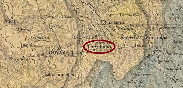
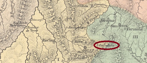
Villiers de l’Ile Adam: Carta (…) da Provincia de Goyaz, 1849
Other names: N. Sra. da Abadia, Itaberaí (1924)
The Freguesia de N. Sra. da Abadia do Curralinho was founded in December 1840 and belonged to the Vila de Goyaz (now Goiás Velho), 40 kilometres to the west. In November 1868 it became a Vila and in July 1903 it was elevated to the Municipio N. Sra. da Abadia. Since August 1924, the município has been called Itaberaí. The indigenous word means “river of glittering stones”.
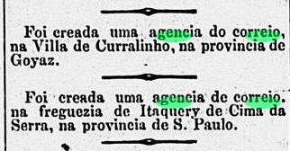
There has been a post office there since August 1888, as can be seen from the Rio press:
Diario de Noticias/RJ, 29/08/1988
No imperial postmark has yet been seen from Curralinho in the province of Goiás.
Atlas do Imperio do Brasil, 1868
Andere Namen: N. Sra. da Abadia, Itaberaí (1924)
Die Freguesia de N. Sra. da Abadia do Curralinho wurde im Dezember 1840 gegründet und gehörte zu der 40 km westlich gelegenen Vila de Goyaz (heute Goiás Velho). Im November 1868 wurde sie zur Vila und im Juli 1903 zum Municipio N. Sra. da Abadia erhoben. Seit August 1924 trägt der Município den Namen Itaberaí. Das indigene Wort bedeutet „Fluss der glitzernden Steine“.
Ein Postamt gab es dort seit August 1888, wie aus der Presse von Rio hervorgeht:
Diario de Noticias/RJ, 29.08.1988
Bisher wurde kein kaiserlicher Poststempel aus Curralinho in der Provinz Goiás gesehen.
Other names: Cidade de Minas, Belo Horizonte (1890)
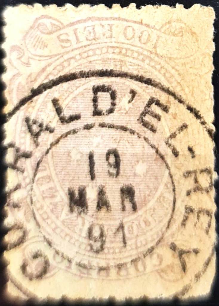
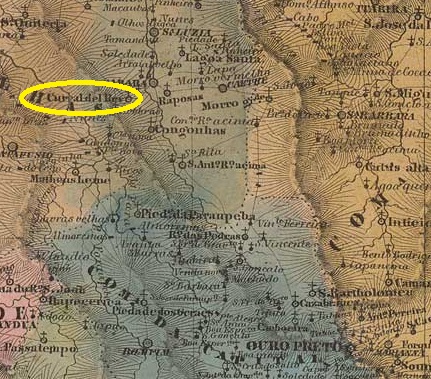
The Freguesia de N. Sra. da Boa Viagem do Curral d’El-Rey was founded in 1750, belonged to the Vila de Sabará and was located 100 kilometres north of the capital Vila Rica (later Ouro Preto). In April 1890, the locality of 8,000 inhabitants was renamed Distrito de Belo Horizonte. In December 1893, it was elevated to Município de Cidade de Minas, as the new capital of the state of Minas Gerais. The name obviously did not catch on, as the city was renamed Belo Horizonte again in July 1901, today a metropolis with over 2 million inhabitants.
As R. Koester (Carimbologia XVI) and Paula Sobrinho (História Postal de Minas Gerais, Belo Horizonte, 1997) write, there had been a post office there since July 1881 with the imperial postmark CMG-0935a (fig. Constantino Papazoglou):
CMG-0935a (CP) 1886-1891Villiers de l’Ile Adam: Carta (…) da Provincia de Minas Geraes, 1849
Andere Namen: Cidade de Minas, Belo Horizonte (1890)
Die Freguesia de N. Sra. da Boa Viagem do Curral d’El-Rey wurde 1750 gegründet, gehörte zur Vila de Sabará und lag 100 km nördlich der Hauptstadt Vila Rica (später Ouro Preto). Im April 1890 wurde die 8.000 Einwohner zählende Stadt in Distrito de Belo Horizonte umbenannt. Im Dezember 1893 erfolgte die Erhebung zum Município de Cidade de Minas, als neue Hauptstadt des Bundesstaates Minas Gerais. Der Name hat sich offensichtlich nicht durchgesetzt, denn bereits im Juli 1901 wurde die Stadt wieder in Belo Horizonte umbenannt, heute eine Metropole mit über 2 Millionen Einwohnern.
Wie R. Koester (Carimbologia XVI) und Paula Sobrinho (História Postal de Minas Gerais, Belo Horizonte, 1997) schreiben, gab es dort seit Juli 1881 ein Postamt mit dem kaiserlichen Poststempel CMG-0935a (Abb. Constantino Papazoglou):
Villiers de l’Ile Adam: Carta (…) das Provincias de Pernambuco, Alagoas e Sergipe, 1848
Other names: Curral das Pedras, Gararu (1877)
Curral de Pedras had been since May 1864 a freguesia of the Vila de Porto da Folha on the south bank of the São Francisco, 150 metres north of the provincial capital Aracaju. In April 1875 this freguesia changed to the Vila da Ilha do Ouro and in March 1877 it became the Vila de Senhor Bom Jesus dos Aflitos de Gararu.
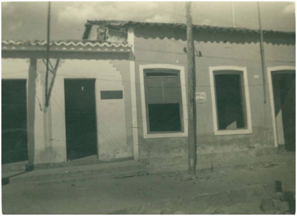
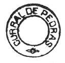
Curral de Pedras post office, around 1960 (IBGE)
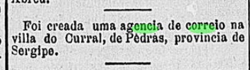
Two dates have been found for the creation of the local post office. Once in 1858, as Nova Monteiro writes in Administrações e Agencias Postaes do Brasil Imperio (Brasil Filatelico/RJ, 1934-5; reprint SPP 1994-1999). Then again in February 1884, as can be seen from the Rio press:
Gazeta de Notícias/RJ, 20/02/1884
The oldest postmark to date is CSE-0050b, shown to us by R. Koester in Carimbologia XV. However, Koester considers this postmark to be already republican:
CSE-0050b (RK)Atlas do Imperio do Brasil, 1868
Andere Namen: Curral das Pedras, Gararu (1877)
Curral de Pedras war seit Mai 1864 eine Freguesia der Vila de Porto da Folha am Südufer des São Francisco, 150 m nördlich der Provinzhauptstadt Aracaju. Im April 1875 ging diese Freguesia zur Vila da Ilha do Ouro und wurde im März 1877 die Vila de Senhor Bom Jesus dos Aflitos de Gararu.
Postamt Curral de Pedras, um 1960 (IBGE)
Für die Gründung des örtlichen Postamtes wurden zwei Daten gefunden. Einmal 1858, wie Nova Monteiro in Administrações e Agencias Postaes do Brasil Imperio (Brasil Filatelico/RJ, 1934-5, Nachdruck SPP 1994-1999) schreibt. Dann wieder im Februar 1884, wie aus der Presse von Rio hervorgeht:
Gazeta de Notícias/RJ, 20.02.1884
Der bisher älteste Poststempel ist CSE-0050b, den uns R. Koester in Carimbologia XV gezeigt hat. Koester hält diesen Stempel jedoch für bereits republikanisch:
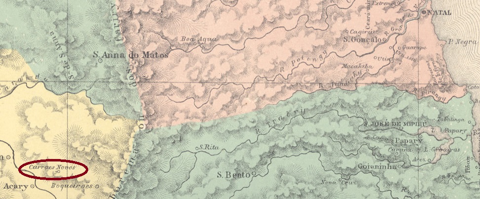
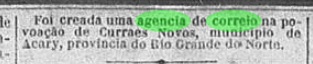
In 1754, a certain Cipriano L. Galvão owned a fazenda called Currais Novos, 180 kilometres west of the later provincial capital of Natal. In July 1788, a village had already been established there, which belonged to the Vila de Caicó. It was elevated to a freguesia in February 1884, when the settlement belonged to the Vila de N. Sra. da Guia de Acary. In October 1890, the Vila de Sant’Anna dos Curraes Novos was founded, which became a town in November 1920.
According to the Rio press, there had been a post office there since November 1887:
Cidade do Rio/RJ, 09/11/1887
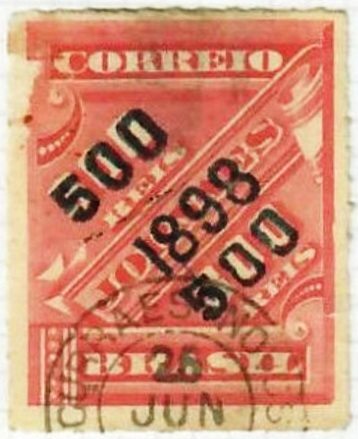
The oldest postmark to date is CRN-0060a (image from the Internet)
CRN-0060a (EB) 1898ffAtlas do Imperio do Brasil, 1868
1754 besaß ein gewisser Cipriano L. Galvão eine Fazenda namens Currais Novos, 180 km westlich der späteren Provinzhauptstadt Natal. Im Juli 1788 war dort bereits ein Dorf entstanden, das zur Vila de Caicó gehörte. Die Erhebung zur Freguesia erfolgte im Februar 1884, danach gehörte die Siedlung zur Vila de N. Sra. da Guia de Acary. Im Oktober 1890 wurde die Vila de Sant’Anna dos Curraes Novos gegründet, die im November 1920 zur Stadt erhoben wurde.
Wie aus der Presse von Rio hervorgeht, gab es dort seit November 1887 ein Postamt:
Cidade do Rio/RJ, 09.11.1887
Der bisher älteste Poststempel ist CRN-0060a (Bild aus dem Internet)
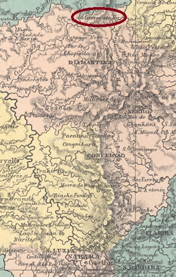
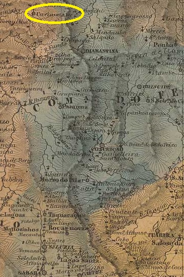
Curimatahy (for the name see Corumbatahy, CSP-0385) was a parish of the Vila de Diamantina on the south bank of the Curimataí, 410 km north of the provincial capital Ouro Preto, from July 1832. In 1861 it became the Freguesia de N. Sra da Conceição do Curimatahy, and since December 1938 it has been a district of the Município de Buenópolis.
Google Maps (Photo: Flávio Almeida)
According to the Rio de Janeiro press, there has been a post office there since November 1881:
Jornal do Commercio/RJ, 12/11/1881
Paula Sobrinho writes in História Postal de Minas Gerais (Belo Horizonte, 1997) that the post office was closed in July 1939. No imperial postmark from Curimatahy in the province of Minas has yet been seen.
Villiers de l’Ile Adam: Carta (…) da Provincia de Minas Geraes, 1849
Curimatahy (zum Namen siehe Corumbatahy, CSP-0385) war seit Juli 1832 eine Pfarrei der Vila de Diamantina am Südufer des Curimataí, 410 km nördlich der Provinzhauptstadt Ouro Preto. 1861 wurde sie zur Freguesia de N. Sra da Conceição do Curimatahy, seit Dezember 1938 ist sie ein Distrikt des Município de Buenópolis.
Google Maps (Foto: Flávio Almeida)
Wie aus der Presse von Rio de Janeiro hervorgeht, gab es dort seit November 1881 ein Postamt:
Jornal do Commercio/RJ, 12.11.1881
Paula Sobrinho schreibt in História Postal de Minas Gerais (Belo Horizonte, 1997), dass das Postamt im Juli 1939 geschlossen wurde. Bisher wurde kein kaiserlicher Poststempel aus Curimatahy in der Provinz Minas gesehen.
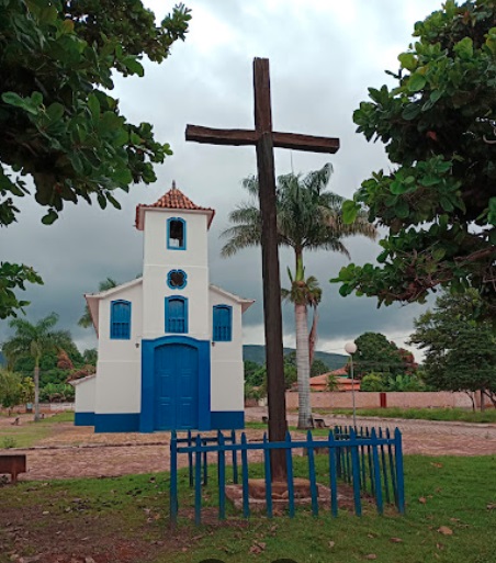
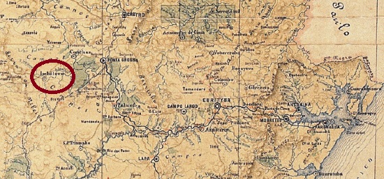
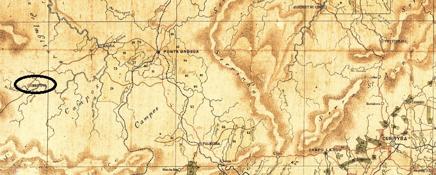
Other names: Santo Antonio de Imbituva, Imbituva (1929)
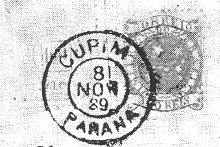
The Freguesia de Campo do Cupim (Termite Field) was founded in February 1876 and belonged to the Vila de Ponta Grossa, 180 kilometres west of the provincial capital Curitiba. In March 1881 it became the Vila de Sto. Antonio de Imbituva, a town since April 1910 and simply Imbituva since April 1929. The name is of Indian origin and means “many lianas”.
As can be seen from the list of imperial post offices (Tabella das Agencias do Correio do Imperio, Rio de Janeiro, 1885), there had been a post office there since 1874. The only imperial postmark to date is CPR-0075b (fig. R. Koester, in Carimbologia XV), which still shows the old place name eight years after it was renamed Imbituva:
CPR-0075b (RK) 1889-1890Estado do Paraná, 1892
Andere Namen: Santo Antonio de Imbituva, Imbituva (1929)
Die Freguesia de Campo do Cupim (Termitenfeld) wurde im Februar 1876 gegründet und gehörte zur Vila de Ponta Grossa, 180 km westlich der Provinzhauptstadt Curitiba. Im März 1881 wurde sie zur Vila de Sto. Antonio de Imbituva, seit April 1910 Stadt und seit April 1929 einfach Imbituva. Der Name ist indianischen Ursprungs und bedeutet „viele Lianen“.
Wie aus dem Verzeichnis der kaiserlichen Postämter (Tabella das Agencias do Correio do Imperio, Rio de Janeiro, 1885) hervorgeht, gab es dort seit 1874 ein Postamt. Der bisher einzige kaiserliche Poststempel ist CPR-0075b (Abb. R. Koester, in Carimbologia XV), der acht Jahre nach der Umbenennung in Imbituva noch den alten Ortsnamen zeigt:
Villiers de l’Ile Adam: Carta (…) da Provincia de São Paulo, 1847
Other names: Falcão
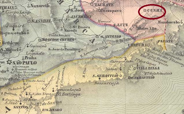
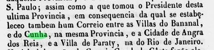
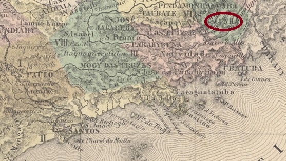
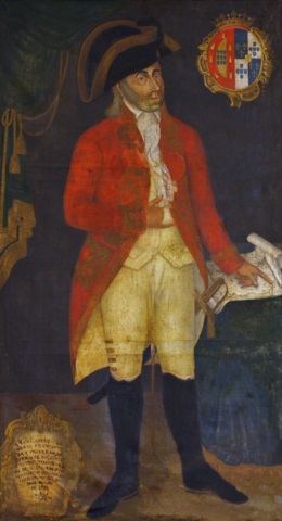
The Freguesia de Falcão was founded in 1736, belonged to the Vila de Guaratinguetá and was located near the border with the later province of Rio de Janeiro, 230 kilometres east of the capitany capital São Paulo. In September 1785, it was elevated to Vila de N. Sra. da Conceição do Cunha. The name was intended to commemorate Francisco de Cunha e Meneses (1747-1812), who was Capitão-Mor of colonial São Paulo from 1782 to 1786. Cunha has been a town since April 1858.
Francisco da Cunha e Meneses (Archaeological Survey of India, Goa)
Previous research has revealed three periods for the operation of the local post office. The first began at the latest in 1838, the year of a letter with the postmark CSP-0415a described in the RHM catalogue:
CSP-0415a (RHM P-SP-10) 1838
The existence of a postal line at that time via Bananal/SP to Paraty and Angra dos Reis in the province of Rio also speaks in favour of postal operations in Cunha in 1838:
Relatorio do Ministerio do Imperio/RJ, 1839
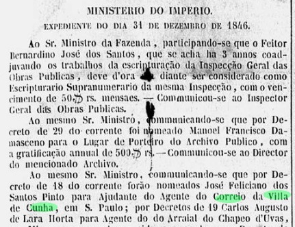
According to the list of imperial post offices (Tabella das Agencias do Correio do Imperio, Rio de Janeiro, 1885), the postal agency in Cunha was reopened in 1847. A postal agent had already been appointed there in December 1846:
Gazeta Official, 11 Jan. 1847
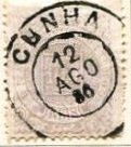
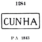
According to the Catálogo Enciclopédico RHM (S. Paulo, 1999), the third opening of a post office in Cunha is said to have taken place in October 1858. Before that, the postmark CSP-0415b (P.A. 1284), which also exists in blue, was already in use:
CSP-0415b (P.A. 1284) 1843ff-1866ff
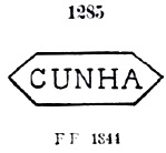
The Catálogo de Carimbos Brasil-Império by P. Ayres (S. Paulo, 1937, 1942) also lists the variant CSP-0415c under no. 1285, but R. Koester (Carimbologia XV) doubts its authenticity:
CSP-0415c (P.A. 1285) 1844ff
The French type postmark CSP-0415d (fig. R. Koester, op.cit.), on the other hand, is beyond doubt. It also exists in blue:
CSP-0415d (RK) 1884-1886
Towards the end of the Empire, CSP-0415e also appeared (illustration from the Internet):
CSP-0415e (EB) 1886-1900Atlas do Imperio do Brasil, 1868
Andere Namen: Falcão
Die Freguesia de Falcão wurde 1736 gegründet, gehörte zur Vila de Guaratinguetá und lag nahe der Grenze zur späteren Provinz Rio de Janeiro, 230 km östlich der Hauptstadt der Capitania de São Paulo. Im September 1785 wurde sie zur Vila de N. Sra. da Conceição do Cunha erhoben. Der Name sollte an Francisco de Cunha e Meneses (1747-1812) erinnern, der von 1782 bis 1786 Capitão-Mor des kolonialen São Paulo war. Seit April 1858 ist Cunha eine Stadt.
Francisco da Cunha e Meneses (Archaeological Survey of India, Goa)
Bisherige Forschungen haben drei Entstehungen für das örtliche Postamt ergeben. Die erste begann spätestens 1838, dem Jahr eines im RHM-Katalog beschriebenen Briefes mit dem Poststempel CSP-0415a:
CSP-0415a (RHM P-SP-10) 1838
Für einen Postbetrieb in Cunha im Jahr 1838 spricht auch die Existenz einer damaligen Postlinie über Bananal/SP nach Paraty und Angra dos Reis in der Provinz Rio:
Relatorio do Ministerio do Imperio/RJ, 1839
Nach dem Verzeichnis der kaiserlichen Postämter (Tabella das Agencias do Correio do Imperio, Rio de Janeiro, 1885) wurde die Postagentur in Cunha 1847 wieder eröffnet. Bereits im Dezember 1846 war dort ein Postagent ernannt worden:
Gazeta Official, 11.01.1847
Nach dem Catálogo Enciclopédico RHM (S. Paulo, 1999) soll die dritte Eröffnung eines Postamtes in Cunha im Oktober 1858 stattgefunden haben. Zuvor wurde bereits der Poststempel CSP-0415b (P.A. 1284) verwendet, der auch in blau existiert:
CSP-0415b (P.A. 1284) 1843ff-1866ff
Im Catálogo de Carimbos Brasil-Império von P. Ayres (S. Paulo, 1937, 1942) ist unter Nr. 1285 auch die Variante CSP-0415c aufgeführt, deren Echtheit jedoch von R. Koester (Carimbologia XV) angezweifelt wird:
CSP-0415c (P.A. 1285) 1844ff
Der Poststempel französischen Typs CSP-0415d (Abb. R. Koester, op.cit.) steht dagegen außer Zweifel. Er existiert auch in blau:
CSP-0415d (RK) 1884-1886
Gegen Ende des Kaiserreichs erschien auch CSP-0415e (Abb. aus dem Internet):
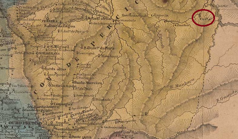
Other names: Borborema, Serra do Cuité, Cuité (1938)
There are two versions of the origins of the Freguesia de N. Sra. das Mercês de Cuité. According to the first, it was founded in 1800, i.e. during the colonial period. The second date is later and more precise: 15 October 1827. Cuité was in any case 220 km north-west of the provincial capital Paraíba do Norte (today: João Pessoa). In May 1854, the first elevation to a Vila took place, followed by others in 1900 and in December 1936 (this time as Município de Serra do Cuité). In the meantime, Cuité was downgraded twice to a district of the Vila de Picuí: in 1891 and 1904. Since November 1938, the município has been called Cuité again.
Nova Monteiro writes in Administrações e Agencias Postaes do Brasil Imperio (Brasil Filatelico/RJ, 1934-5; reprint SPP 1994-1999) that there had been a post office there since October 1858. This date is confirmed by the postal report (Relatório Postal) for 1887. The only imperial postmark to date is CPB-0125b (fig. Jorge L. Pedreira):
CPB-0125b (JP) 1881Villiers de l’Ile Adam: Carta (…) das Provincias do Rio Grande do Norte e Parahiba
Andere Namen: Borborema, Serra do Cuité, Cuité (1938)
Über die Entstehung der Freguesia de N. Sra. das Mercês de Cuité gibt es zwei Versionen. Nach der ersten wurde sie im Jahre 1800 gegründet, also bereits in der Kolonialzeit. Das zweite Datum ist später und genauer: 15.10.1827. Cuité lag jedenfalls 220 km nordwestlich der Provinzhauptstadt Paraíba do Norte (heute: João Pessoa). Im Mai 1854 erfolgte die erste Erhebung zur Vila, weitere folgten 1900 und im Dezember 1936 (diesmal als Município de Serra do Cuité). In der Zwischenzeit wurde Cuité zweimal zum Distrikt der Vila de Picuí herabgestuft: 1891 und 1904. Seit November 1938 heißt der Município wieder Cuité.
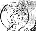
Nova Monteiro schreibt in Administrações e Agencias Postaes do Brasil Imperio (Brasil Filatelico/RJ, 1934-5; Reprint SPP 1994-1999), dass es dort seit Oktober 1858 ein Postamt gab. Dieses Datum wird durch den Postbericht (Relatório Postal) für 1887 bestätigt. Der bisher einzige kaiserliche Poststempel ist CPB-0125b (Abb. Jorge L. Pedreira):
Carta da Republica dos Estados Unidos do Brazil, 1892
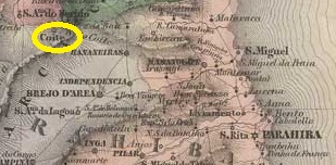
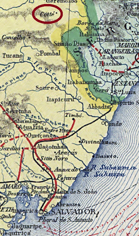
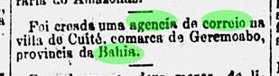
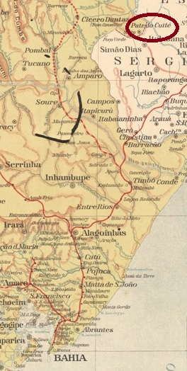
Other names: Coité, Patrocínio do Coité, Paripiranga (1931)
The Freguesia de N. Sra. do Patrocinio do Coité was founded in May 1871 and belonged to the Vila de Geremoabo on the provincial border with Sergipe, 320 kilometres north of the provincial capital Salvador da Bahia. In May 1886 it was elevated to the status of a Vila and since March 1931 it has been the Município de Paripiranga. The Indian name means red earth.
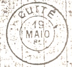
According to the Rio de Janeiro press, there has been a post office there since July 1887:
O Paiz/RJ, 31/07/1887
No imperial postmark from Cuité has yet been seen.
Estado da Bahia, 1913
Andere Namen: Coité, Patrocínio do Coité, Paripiranga (1931)
Die Freguesia de N. Sra. do Patrocinio do Coité wurde im Mai 1871 gegründet, sie gehörte der Vila de Geremoabo und lag an der Provinzgrenze zu Sergipe, 320 km nördlich der Provinzhauptstadt Salvador da Bahia. Im Mai 1886 erfolgte die Erhebung zur Vila und seit März 1931 ist der Ort Município de Paripiranga. Der indianische Name bedeutet rote Erde.
Wie der Presse von Rio de Janeiro zu entnehmen ist, gab es dort seit Juli 1887 ein Postamt:
O Paiz/RJ, 31.07.1887
Bisher wurde kein kaiserlicher Poststempel aus Cuité gesehen.
Villiers de l’Ile Adam: Carta (…) da Provincia de Minas Geraes, 1849
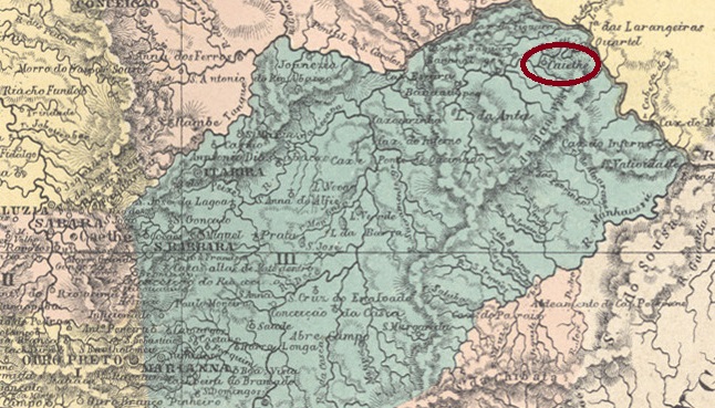
Other names: Degredo, Cuieté, Cuyethi, Cuité, Barra do Cuieté, Cuieté Velho (1953)
The Freguesia de N. Sra. da Conceição do Cuiethé was founded in 1824 on the south bank of the Cuieté (now Caratinga) in the Vila de Manhuaçu, 350 kilometres north-east of the provincial capital Ouro Preto. The Indian name means “vessel” and the place originated as a prison, hence the original name Degredo (exile).
Cuiethé became a district of Vila de Caratinga in February 1890 and as such went to the Município de Itanhomi in September 1923. There were then two name changes: in December 1938 to Barra do Cuieté (then in the Município de Conselheiro Pena) and five years later to Cuieté Velho.
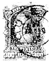
Both R. Koester in Carimbologia XV and Paula Sobrinho in História Postal de Minas Gerais (Belo Horizonte, 1997) agree that there has been a post office there since October 1881. The imperial postmark is CMG-0920a (fig. Koester, op. cit.):
CMG-0920a (RK) 1885-1890Atlas do Imperio do Brasil, 1868
Andere Namen: Degredo, Cuieté, Cuyethi, Cuité, Barra do Cuieté, Cuieté Velho (1953)
Die Freguesia de N. Sra. da Conceição do Cuiethé wurde 1824 gegründet und lag am Südufer des Cuieté (heute Caratinga-Fluss) im Gebiet der Vila de Manhuaçu, 350 km nordöstlich der Provinzhauptstadt Ouro Preto. Der indianische Name bedeutet “Gefäß” und der Ort entstand als Gefängnis, daher der ursprüngliche Name Degredo (Verbannung).
Cuiethé wurde im Februar 1890 zum Bezirk der Vila de Caratinga und wechselte als solcher im September 1923 zum Município de Itanhomi. Danach gab es zwei Namensänderungen: im Dezember 1938 in Barra do Cuieté (dann im Município de Conselheiro Pena) und fünf Jahre später in Cuieté Velho.
Sowohl R. Koester in Carimbologia XV als auch Paula Sobrinho in História Postal de Minas Gerais (Belo Horizonte, 1997) sind sich einig, dass es dort seit Oktober 1881 ein Postamt gab. Der kaiserliche Poststempel ist CMG-0920a (Abb. Koester, op. cit.):