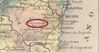
Carta Corographica da Provincia de Pernambuco, 1880
Other names: Jaboatão dos Guararapes, Vila Rica
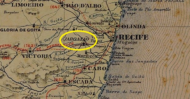
Since March 1764 there was the Freguesia de Sto. Amaro de Jaboatão on the banks of the Jaboatão, which belonged to the city of Recife, 20 kilometres to the east. In May 1873, it was elevated to a Vila and in June 1884 to a city. Since May 1989, the former freguesia has been in the district of Vila Rica, Município de Jaboatão dos Guararapes.
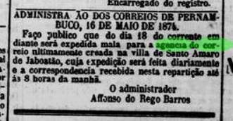
As can be seen from the list of imperial post offices (Tabella das Agencias do Correio do Imperio, Rio de Janeiro, 1885), it was decided in 1873 to set up a post office. However, this did not start operating until the following year:
Diario de Pernambuco, 19/03/1874
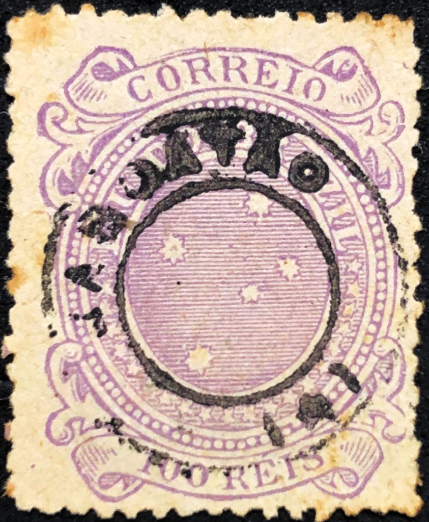
The oldest postmark to date is the French type JPE-0335a (coll. Marco Morel):
JPE-0335a (ME) 1885-1890ff
At the beginning of the Republic, JPE-0335b was also used (illustration from the Internet):
JPE-0335b (EB) 1891-1892Atlas do Imperio do Brasil, 1868
Andere Namen: Jaboatão dos Guararapes, Vila Rica
Seit März 1764 besteht die Freguesia de Sto. Amaro de Jaboatão am Ufer des Jaboatão, die zur 20 km östlich gelegenen Stadt Recife gehörte. Im Mai 1873 wurde sie zur Vila und im Juni 1884 zur Stadt erhoben. Seit Mai 1989 befindet sich die ehemalige Freguesia im Stadtteil Vila Rica, Município de Jaboatão dos Guararapes.
Wie aus dem Verzeichnis der kaiserlichen Postämter (Tabella das Agencias do Correio do Imperio, Rio de Janeiro, 1885) hervorgeht, wurde 1873 die Einrichtung eines Postamtes beschlossen. Dieses nahm jedoch erst im folgenden Jahr seinen Betrieb auf:
Diario de Pernambuco, 19.03.1874
Der bisher älteste Poststempel ist der französische Typ JPE-0335a (Samml. Marco Morel):
JPE-0335a (ME) 1885-1890ff
Zu Beginn der Republik wurde auch JPE-0335b verwendet (Abbildung aus dem Internet):
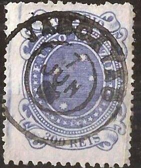
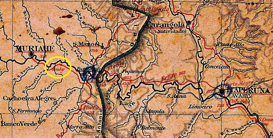
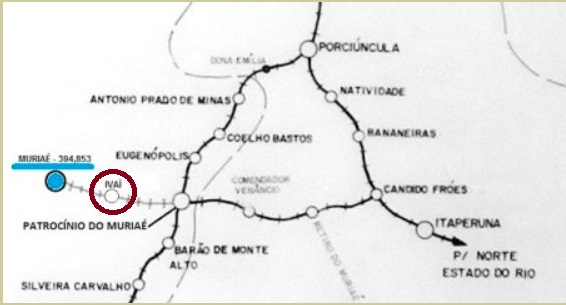
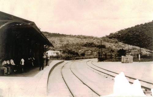
This station was opened in January 1886 by the railway company E.F. Leopoldina (Muriaé branch) and was located on the south bank of the Muriaé in the Município de S. Paulo do Muriaé, 220 km south-east of the capital Ouro Preto. The station had been in the Município de Patrocínio do Muriaé since December 1953 and was closed in 1966. Today, the tracks and station building have disappeared from the district of Ivaí (as it is now spelt). The name comes from the Tupi-guarani and means river of fruits.
In July 2009 (photo Marcus Manhães, on estacoesferroviarias.com.br)
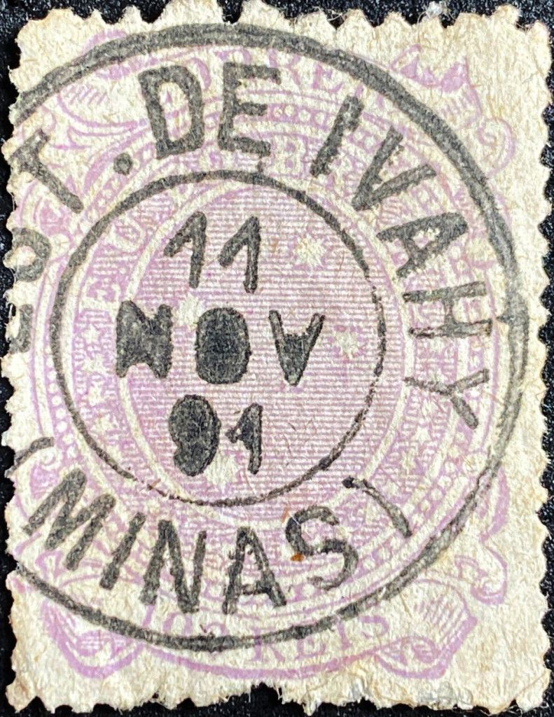
Paula Sobrinho (História Postal de Minas Gerais, Belo Horizonte, 1997) and R. Koester (Carimbologia XXIV) agree that there has been a post office there since February 1886. The imperial postmark is IMG-1390a (fig. Roberto Assef Fo.):
Dieser Bahnhof wurde im Januar 1886 von der Eisenbahngesellschaft E.F. Leopoldina (Muriaé-Zweig) eröffnet und lag am Südufer des Muriaé im Município de S. Paulo do Muriaé, 220 km südöstlich der Hauptstadt Ouro Preto. Der Bahnhof befand sich seit Dezember 1953 im Município de Patrocínio do Muriaé und wurde 1966 stillgelegt. Heute sind Gleise und Bahnhofsgebäude aus dem Stadtteil Ivaí (wie es heute geschrieben wird) verschwunden (estacoesferroviarias.com.br). Der Name stammt aus dem Tupi-guarani und bedeutet Fluss der Früchte.
Im Juli 2009 (Foto Marcus Manhães, auf estacoesferroviarias.com.br)
Paula Sobrinho (História Postal de Minas Gerais, Belo Horizonte, 1997) und R. Koester (Carimbologia XXIV) sind sich einig, dass es dort seit Februar 1886 ein Postamt gab. Der kaiserliche Poststempel ist IMG-1390a (Abb. Roberto Assef Fo.):
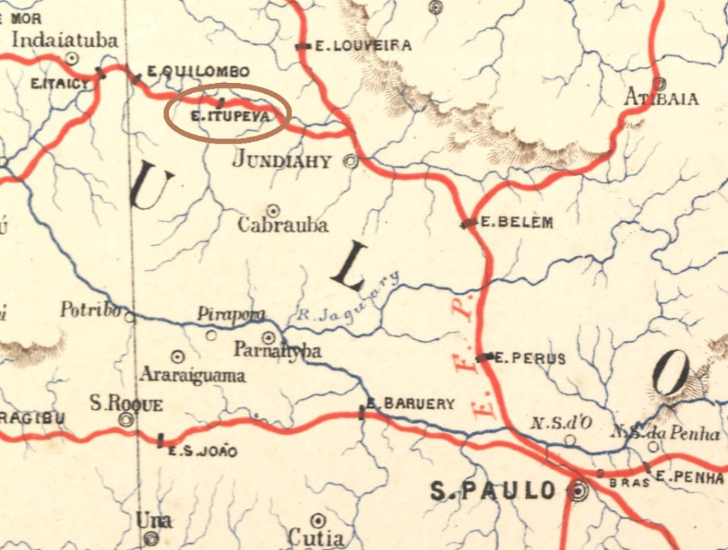
J. M. Ribeiro Lisboa: Provincia de São Paulo, 1884
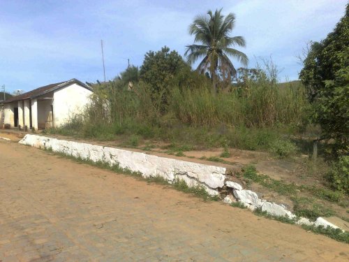
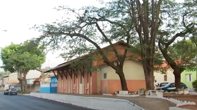
Itupeva station was opened in 1873 by the E.F. Ytuana railway company (Jundiaí branch), located on the south bank of the Jundiaí in the Município of the same name, 70 km north-west of the capital São Paulo. The line then changed hands four times: in 1892 to the Cia. União Sorocabana e Ytuana, in 1907 to the Sorocabana Railway, in 1919 to E.F. Sorocabana, and from 1971 until its closure in 1973 it belonged to FEPASA (estacoesferroviarias.com.br). Today, the tracks have disappeared and the station building belongs to the municipality. Since February 1964, the station site has been part of the Município de Itupeva. The word comes from the Tupi-guarani language and means shallow waterfall.
Around 1960 (Photo: Mauricio Poli, on estacoesferroviarias.com.br)In 2016 (Youtube)
According to the list of imperial post offices (Tabella das Agencias do Correio do Imperio, Rio de Janeiro, 1885), there was a post office at the railway station since 1880. The imperial postmark is the French type ISP-1970a (collect. Fuad Ferreira Fo.), which also exists in blue:
ISP-1970a (FF) 1884-1889E. F. Central do Brasil, 1890
1873 wurde der Bahnhof Itupeva von der Eisenbahngesellschaft E.F. Ytuana (Jundiaí-Zweig) eröffnet, er lag am Südufer des Jundiaí im gleichnamigen Município, 70 km nordwestlich der Hauptstadt São Paulo. Danach wechselte die Strecke viermal den Besitzer: 1892 an die Cia. União Sorocabana e Ytuana, 1907 an die Sorocabana Railway, 1919 an E.F. Sorocabana, von 1971 bis zur Stilllegung 1973 gehörte sie der FEPASA (estacoesferroviarias.com.br). Heute sind die Gleise verschwunden, das Bahnhofsgebäude gehört der Gemeinde. Seit Februar 1964 befindet sich das Bahnhofsgelände im Município de Itupeva. Das Wort stammt aus der Sprache der Tupi-guarani und bedeutet seichter Wasserfall.
Um 1960 (Foto: Mauricio Poli, auf estacoesferroviarias.com.br)2016 (Youtube)
Wie aus dem Verzeichnis der kaiserlichen Postämter (Tabella das Agencias do Correio do Imperio, Rio de Janeiro, 1885) hervorgeht, gab es ein Postamt am Bahnhof seit 1880. Der kaiserliche Poststempel ist der französische Typ ISP-1970a (Samml. Fuad Ferreira Fo.), den es auch in blau gibt:
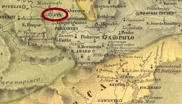
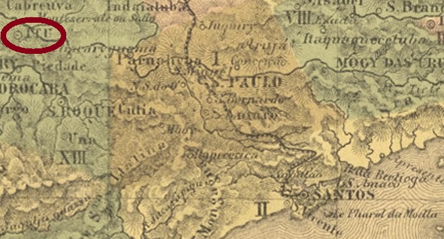
Villiers de l’Ile Adam: Carta (…) da Provincia de São Paulo, 1847
This village, old by Brazilian standards, was the chapel of N. Sra. da Candelária from February 1610 and was located on the south bank of the Tietê, barely 100 km west of the later provincial capital of São Paulo. Ytu became a freguesia in 1653, a vila in April 1657 and a town in February 1842.
Two years of origin for the local post office have been found. First in October 1824, as Nova Monteiro writes in Administrações e Agencias Postaes do Brasil Imperio (Brasil Filatelico/RJ, 1934-5; Reprint SPP 1994-1999). Then in 1844, according to the Directory of Imperial Post Offices (Tabella das Agencias do Correio do Imperio, Rio de Janeiro, 1885).
The first two postmarks have been definitively used in the pre-philatelic period. YSP-1615a was in use at least between 1825 and 1829 and was already made known by the RHM catalogue:
YSP-1615a (RHM P-SP-59)
Parallel to this – more precisely between 1825 and at least 1850 – YSP-1615b was in use, which can not only be seen in the RHM, but was also recorded with no. 1542 in the Catálogo de Carimbos Brasil-Império (S. Paulo, 1937, 1942) by Paulo Ayres:
YSP-1615b (RHM P-SP-60, P.A. 1542)
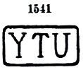
Then there came YSP-1615c, used between about 1843 and at least 1877. This postmark also exists in red; it can be seen in the Paulo Ayres (op. cit.) with no. 1541:
YSP-1615c (P.A. 1541)
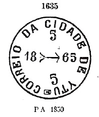
Its successor YSP-1615d came into use from about 1850 – also in red – and is also listed in Paulo Ayres, this time under no. 1635:
YSP-1615d (P.A. 1635)
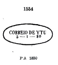
YSP-1615e was also in use about the same time and can also be seen in P. Ayres. Later cancels present a dot after YTU:
YSP-1615e (P.A. 1554) 1850ff-1881
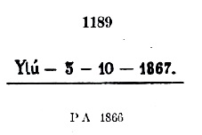
Also YSP-1615f, which also occurs in blue between 1866 and 1881, with P. Ayres no. 1189. However, the dot at the end may sometimes be missing:
YSP-1615f (P.A. 1189)
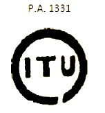
All the following postmarks have ITU written with I. ISP-0660a was in circulation from about 1866 and was given No. 1331 by P. Ayres:
ISP-0660a (P.A. 1331)
ISP-0660b apparently occurred in blue, was in use from ca. 1866 to ca. 1877 and has no. 1332 by P. Ayres:
ISP-0660b (P.A. 1332)
Five more postmarks followed as double circles until the end of the 19th century. The French type ISP-0660c (Coll. José L. Fevereiro) has the inscription ITÚ above and the asterisk between brackets below. Dates in the centre go from 1868 to 1879. ISP-0660d (Coll. Mário Celso Orsi Jr.) also exists in violet and blue, with internal dates from 1881 to 1887. Here the accent on the U is barely visible, if at all. ISP-0660e (Coll. Mário Celso Orsi Jr.) is also found in violet, has ITU written in wide letters at the top and a five-pointed star without brackets at the bottom, with inner dates from 1886 to 1890. In ISP-0660f (image from the internet) we have a Correio Ambulante cancel, with (C.A.) below. Dates from 1885 to 1887. Finally, ISP-0660g (image by Luís C. Fritzen) is a second French type, but this time the letters of ITU are narrower. A specimen from 1897 was found.
Mário Celso Orsi Jr. also presents a handwritten cancellation from Itu:
1866ff (MO)
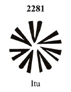
Then we have three mute cancellations from there. The first of these has already been presented by J. Dingler and K. W. Lopes in Mute Cancellations of the Brazil Empire / Carimbos Mudos do Brasil Império (Brazil Philatelic Association, Rio de Janeiro, 2000) under no. 2281:
BPA 2281 (1868)
The second mute cancel comes from the Fuad Ferreira Fo. collection:
1867 (FF)
Lastly, another mute cancellation, as announced by Mário Celso Orsi Jr:
1872-1881 (MO)Atlas do Imperio do Brasil, 1868
Diese für brasilianische Verhältnisse alte Ortschaft war ab Februar 1610 die Kapelle von N. Sra. da Candelária und lag am Südufer des Tietê, knapp 100 km westlich der späteren Provinzhauptstadt São Paul. Ytu wurde 1653 zur Freguesia, im April 1657 zur Vila und im Februar 1842 zur Stadt.
Zwei Entstehungsjahre fürs örtliche Postamt wurden gefunden. Erstmals im Oktober 1824, wie Nova Monteiro in Administrações e Agencias Postaes do Brasil Imperio (Brasil Filatelico/RJ, 1934-5; Reprint SPP 1994-1999) schreibt. Dann 1844, laut Verzeichnis der kaiserlichen Postämter (Tabella das Agencias do Correio do Imperio, Rio de Janeiro, 1885).
Die ersten beiden Poststempel sind nachweislich in der Vorphila-Zeit verwendet worden. YSP-1615a war zumindest zwischen 1825 und 1829 in Gebrauch und wurde bereits durch den RHM-Katalog bekannt gemacht:
YSP-1615a (RHM P-SP-59)
Parallel dazu – genauer zwischen 1825 bis zumindest 1850 – wurde YSP-1615b verwendet, der nicht nur im RHM zu sehen ist, sondern auch mit Nr. 1542 im Catálogo de Carimbos Brasil-Império von Paulo Ayres registriert wurde:
YSP-1615b (RHM P-SP-60, P.A. 1542)
Danach kam YSP-1615c, verwendet zwischen ca. 1843 und mindestens 1877. Diesen Poststempel gibt es auch in Rot, er ist im Paulo Ayres (op. cit.) mit Nr. 1541 zu sehen:
YSP-1615c (P.A. 1541)
Sein Nachfolger YSP-1615d kam ab ca. 1850 in Gebrauch – auch in Rot – und ist ebenfalls in Paulo Ayres aufgelistet, diesmal unter Nr. 1635:
YSP-1615d (P.A. 1635)
Auch YSP-1615e wurde etwa zur gleichen Zeit verwendet und ist auch im P. Ayres zu sehen, wobei später ein Punkt nach YTU erscheinen kann:
YSP-1615e (P.A. 1554) 1850ff-1881
Ebenfalls YSP-1615f, der auch in Blau zwischen 1866 und 1881 vorkommt, mit P. Ayres Nr. 1189. Allerdings kann der Punkt am Ende manchmal fehlen:
YSP-1615f (P.A. 1189)
Alle folgenden Poststempel haben ITU mit I geschrieben. ISP-0660a war ab ca. 1866 im Umlauf und bekam von P. Ayres die Nr. 1331:
ISP-0660a (P.A. 1331)
ISP-0660b kommt angeblich in Blau vor, wurde von ca. 1866 bis ca. 1877 verwendet und hat Nr. 1332 bei P. Ayres:
ISP-0660b (P.A. 1332)
Es folgten noch fünf Poststempel als Doppelkreise bis Ende des 19. Jahrhunderts. Der französische Typus ISP-0660c (Samml. José L. Fevereiro) hat oben die Inschrift ITÚ und unten des Sternchen zwischen Klammern. Daten in der Mitte von 1868 bis 1879. ISP-0660d (Samml. Mário Celso Orsi Jr.) gibt es auch in Violett und Blau, mit inneren Daten von 1881 bis 1887. Hier ist der Akzent auf dem U kaum oder nicht zu sehen. ISP-0660e (Samml. Mário Celso Orsi Jr.) kommt auch in Violett vor, hat oben ITU mit breiten Buchstaben geschrieben und unten einen fünfzackigen Stern ohne Klammer, dazu innere Daten von 1886 bis 1890. In ISP-0660f (Bild aus dem Internet) haben wir einen Stempel von Correio Ambulante, mit (C.A.) darunter. Datiert von 1885 bis 1887. Schließlich kommt mit ISP-0660g (Abb. Luís C. Fritzen) ein zweiter französischer Typ dazu, wobei die Buchstaben von ITU diesmal schmäler sind. Ein Exemplar aus 1897.
Mário Celso Orsi Jr. kennt auch eine handschriftliche Entwertung aus Itu:
1866ff (MO)
Dann haben wir noch drei stumme Abstempelungen von dort. Die erste davon wurde bereits durch J. Dingler und K. W. Lopes in Mute Cancellations of the Brazil Empire / Carimbos Mudos do Brasil Império (Brazil Philatelic Association, Rio de Janeiro, 2000) unter Nr. 2281 vorgestellt:
BPA 2281 (1868)
Die zweite stumme Abstempelung kommt aus der Sammlung Fuad Ferreira Fo.:
1867 (FF)
Zuletzt eine stumme Abstempelung, wie Mário Celso Orsi Jr. bekannt gab:
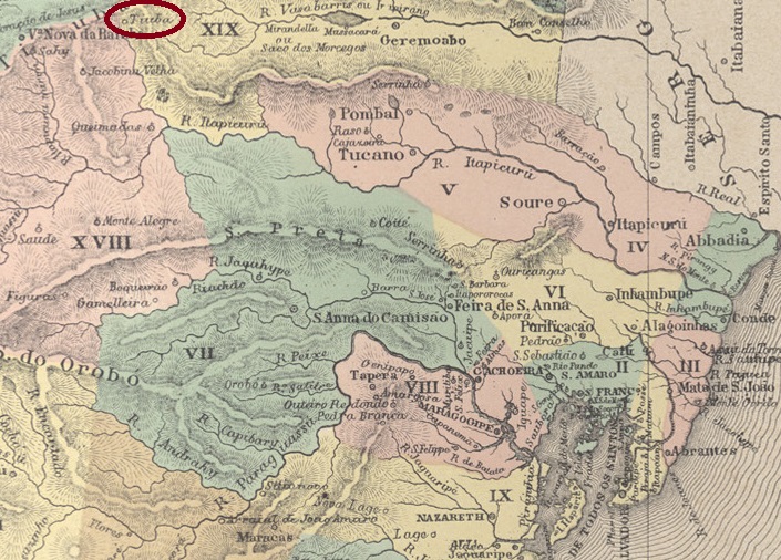
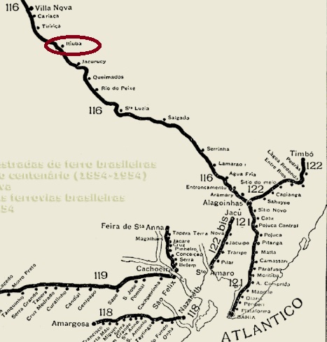
Founded in March 1868, Arraial de S. Gonçalo do Amarante da Serra da Itiúba belonged to Vila Nova da Rainha (now Senhor do Bonfim) and was located around 380 km north-west of the colonial capital Salvador da Bahia. In 1882, the entire settlement was moved to the neighbouring Fazenda Salgada. In June 1884, it was elevated to a freguesia, subordinated to the Vila de Sto. Antonio das Queimadas, and the Município de Itiúba has existed since January 1935. The name comes from the Tupi-guarani and means golden bee.
R. Koester writes in Carimbologia XXIV that there has been a post office there since March 1887. This is confirmed by the report of the president of the province:
Relatorio do Presidente da Provincia, October 1887
Since a railway station of the E.F. de Alagoinhas a Joazeiro had already been opened at the location in April of that year, this was probably a railway post office. Imperial postmarks from Itiuba have not yet been found.
Estradas de Ferro na Bahia, 1898 (IBGE, 1958)
Andere Namen: Fazenda Salgada, Tiúba
Der im März 1868 gegründete Arraial de S. Gonçalo do Amarante da Serra da Itiúba gehörte zur Vila Nova da Rainha (heute Senhor do Bonfim) und lag ca. 380 km nordwestlich der Kolonialhauptstadt Salvador da Bahia. 1882 wurde die gesamte Siedlung auf die benachbarte Fazenda Salgada verlegt. Im Juni 1884 wurde sie zur Freguesia erhoben, die Vila de Sto. Antonio das Queimadas untergeordnet, und seit Januar 1935 besteht der Município de Itiúba. Der Name stammt aus dem Tupi-guarani und bedeutet goldene Biene.
R. Koester schreibt in Carimbologia XXIV, dass es dort seit März 1887 ein Postamt gab. Dies wird durch den Bericht des Präsidenten der Provinz bestätigt:
Relatorio do Presidente da Provincia, Oktober 1887
Da bereits im April d.J. ein Bahnhof der E.F. de Alagoinhas a Joazeiro am Ort eröffnet wurde, handelt es sich hier vermutlich um ein Bahnhofspostamt. Kaiserliche Poststempel aus Itiuba wurden bisher nicht gefunden.
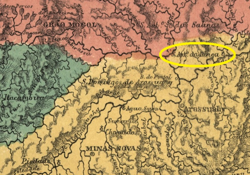
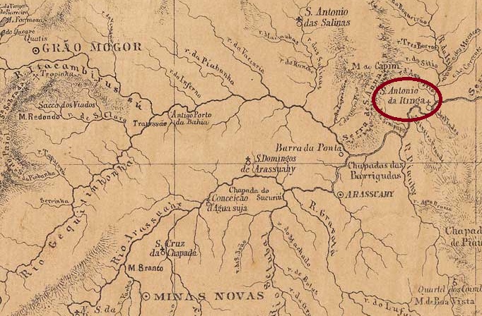
There was since 1805 the settlement of Sto. Antonio do Barreiro de Itinga on the north bank of the Jequitinhonha, 670 kilometres north of the later provincial capital Ouro Preto. In May 1850, it became the Distrito de Sto. Antonio do Itinga, which belonged to Vila de Minas Novas. This was followed in April 1854 by the elevation to a freguesia, this time under the Vila de Arassuahy. Itinga has been an independent município since December 1943. The word comes from the Tupi-guarani and means clear water.
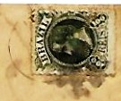
Paula Sobrinho (História Postal de Minas Gerais, Belo Horizonte, 1997) and R. Koester (Carimbologia XXIV) agree that there had been a post office there since January 1879. Initially, the stamps were cancelled by hand, as the illustration in Koester (op. cit.) shows.
1882ff (RK)
Later, the double circle IMG-1385a (illustration by Claudio Coelho) was added, which also exists in red-brown:
IMG-1385a (CC) 1885ff-1888Provincia de Minas Geraes, 1873
Seit 1805 existierte die Siedlung Sto. Antonio do Barreiro de Itinga am Nordufer des Jequitinhonha, 670 km nördlich der späteren Provinzhauptstadt Ouro Preto. Im Mai 1850 wurde der Distrito de Sto. Antonio do Itinga, der zu Vila de Minas Novas gehörte. Im April 1854 folgte die Erhebung zur Freguesia, diesmal von Vila de Arassuahy aus. Seit Dezember 1943 ist Itinga ein unabhängiges Município. Das Wort stammt aus dem Tupi-guarani und bedeutet klares Wasser.
Paula Sobrinho (História Postal de Minas Gerais, Belo Horizonte, 1997) und R. Koester (Carimbologia XXIV) sind sich einig, dass es dort seit Januar 1879 ein Postamt gab. Anfangs wurden die Briefmarken noch von Hand entwertet, wie die Abbildung bei Koester (a.a.O.) zeigt.
1882ff (RK)
Später kam der Doppelkreis IMG-1385a (Abb. Claudio Coelho) hinzu, der auch in rotbraun existiert:
Villiers de l’Ile Adam: Carta (…) da Provincia de Minas Geraes, 1849
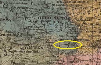
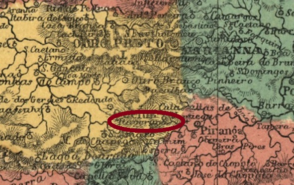
Other names: Itaberaba
The Freguesia de Sto. Antonio do Itaverava was founded in January 1752, belonged to the Vila de Queluz and was located more than 50 kilometres south of the later provincial capital Ouro Preto. The village became a distrito in the Município de Conselheiro Lafaiete in March 1934 and has been the Município de Itaverava since December 1962. The name from tupi-guarani means shining stone.
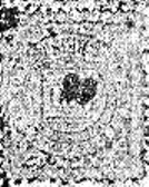
Here, too, Paula Sobrinho (História Postal de Minas Gerais, Belo Horizonte, 1997) and R. Koester (Carimbologia XXIV) agree that there had been a local post office since August 1879. The imperial postmark is IMG-1380a (fig. Koester, op. cit.):
IMG-1380a (RK) 1885-1886Atlas do Imperio do Brasil, 1868
Andere Namen: Itaberaba
Die Freguesia de Sto. Antonio do Itaverava wurde im Januar 1752 gegründet, gehörte zur Vila de Queluz und lag mehr als 50 km südlich der späteren Provinzhauptstadt Ouro Preto. Der Ort wurde im März 1934 ein Distrito im Município de Conselheiro Lafaiete und ist seit Dezember 1962 das Município de Itaverava. Der Begriff aus dem Tupi-guarani bedeutet glänzender Stein.
Auch hier sind sich Paula Sobrinho (História Postal de Minas Gerais, Belo Horizonte, 1997) und R. Koester (Carimbologia XXIV) einig, dass es seit August 1879 ein Postamt in Itaverava gab. Der kaiserliche Poststempel ist IMG-1380a (Abb. Koester, op. cit.):
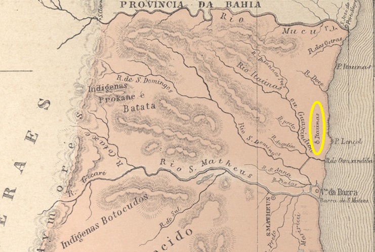
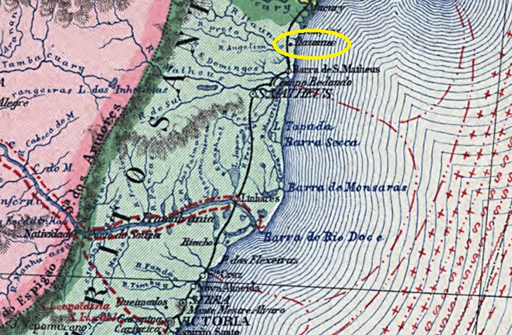
The Freguesia de S. Sebastião das Itaunas, founded in July 1861, belonged to the Vila de Barra de S. Matheus and was located on the west bank of the Itaúnas near its mouth into the Atlantic Ocean. Since September 1891, Itaúnas (current spelling) has been a district in the Município Conceição da Barra. The word comes from the Tupi-guarani and means yellow stones.
In March 1860, the decision was made to create a post office in the area, as reported in the Rio press:
Jornal do Commercio/RJ, 20/04/1860
According to P. Novaes (agenciaspostais.com.br), the postal agency was closed around 1869, and in October 1878 it was no longer listed among the post offices of Espírito Santo, although it was mentioned in the postal guide (Guia Postal do Imperio, Rio de Janeiro, 1880). No imperial postmarks from Itaunas are known to date.
Carta da Republica dos Estados Unidos do Brazil, 1892
Die im Juli 1861 gegründete Freguesia de S. Sebastião das Itaunas gehörte zur Vila de Barra de S. Matheus und lag am Westufer des Itaúnas nahe seiner Mündung in den Atlantik. Seit September 1891 ist Itaúnas (heutige Schreibweise) ein Distrito im Município Conceição da Barra. Das Wort stammt aus dem Tupi-guarani und bedeutet gelbe Steine.
Im März 1860 wurde der Beschluss gefasst, ein Postamt vor Ort einzurichten, wie die Presse in Rio berichtete:
Jornal do Commercio/RJ, 20.04.1860
Laut P. Novaes (agenciaspostais.com.br) wurde die Postagentur um 1869 geschlossen, und im Oktober 1878 war sie nicht mehr unter den Postämtern von Espírito Santo aufgeführt, obwohl sie im Postführer (Guia Postal do Imperio, Rio de Janeiro, 1880) erwähnt wurde. Bis heute sind keine kaiserlichen Poststempel von Itaunas bekannt.
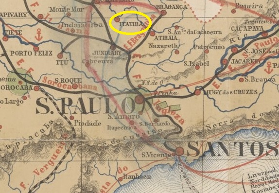
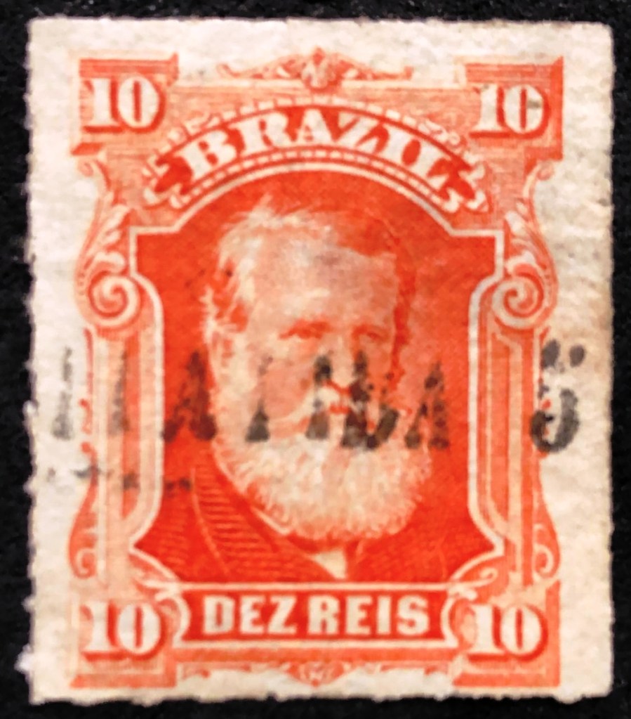
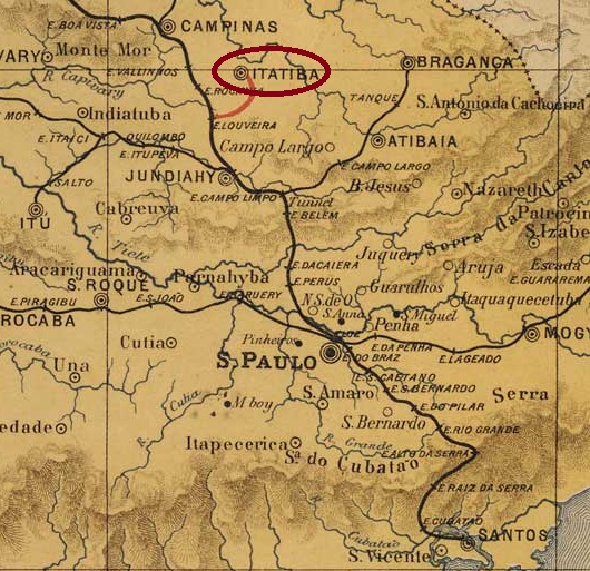
The Freguesia of N. Sra. de Belém was founded in December 1830 in the Município of Jundiaí and was located on the south bank of the river Atibaia, 80 km north of the provincial capital São Paulo. The place became a vila in February 1857 and a town in March 1876, renamed Itatiba a year later, probably to avoid confusion with places of the same name. The word from the Tupi-Guarany language means many stones.
As Nova Monteiro writes in Administrações e Agencias Postaes do Brasil Imperio (Brasil Filatelico/RJ, 1934-5; Reprint SPP 1994-1999), there had been a post office there since November 1859. The first postmark with the new place name is ISP-0140a (fig. Roberto Assef Jr.):
ISP-0140a (RA) 1877ff-1878ff
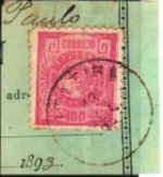
This was followed by the French type ISP-0140b, which was illustrated in P. Ayres’ Catálogo de Carimbos Brasil-Império (S. Paulo, 1937, 1942):
ISP-0140b (P.A. p. 117) 1879-1887
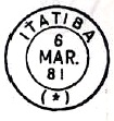
Then came the rare ISP-0140c (fig. R. Koester, in Carimbologia XXIV):
ISP-0140c (RK) 1888ff
ISP-0140d (ill. Mário Celso Orsi Jr.) also appeared at the beginning of the Republic:
ISP-0140d (MO) 1893-1899
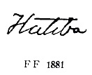
P. Ayres (op. cit.) also showed a handwritten cancellation from there:
1881ff (P.A. p. 147)
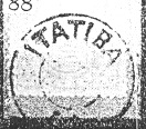
And José L. Fevereiro presented a mute cancellation from Itatiba:
1883 (JLF)
For postmarks with Bethlem de Jundiahy (until 1878) see BSP-0560).
J.M. Ribeiro Lisboa: Provincia de São Paulo,1884
Siehe auch Bethlem de Jundiahy (BSP-0560)
Die Freguesia von N. Sra. de Belém wurde im Dezember 1830 im Município von Jundiaí gegründet und lag am Südufer des Flusses Atibaia, 80 km nördlich der Provinzhauptstadt São Paulo entfernt. Der Ort wurde im Februar 1857 eine Vila und im März 1876 eine Stadt, die ein Jahr später zu Itatiba umbenannt wurde, wohl um Verwechslungen mit gleichnamigen Orten zu vermeiden. Das Wort aus der Tupi-Guarany-Sprache bedeutet viele Steine.
Wie Nova Monteiro in Administrações e Agencias Postaes do Brasil Imperio (Brasil Filatelico/RJ, 1934-5; Reprint SPP 1994-1999) schreibt, gab es dort ein Postamt seit November 1859. Der erste Poststempel mit dem neuen Ortsnamen ist ISP-0140a (Abb. Roberto Assef Jr.):
ISP-0140a (RA) 1877ff-1878ff
Es folgte der französischer typ ISP-0140b, der im P. Ayres’ Catálogo de Carimbos Brasil-Império (S. Paulo, 1937, 1942) abgebildet wurde:
ISP-0140b (P.A. S. 117) 1879-1887
Danach kam der seltene ISP-0140c (Abb. R.Koester, in Carimbologia XXIV):
ISP-0140c (RK) 1888ff
Am Anfang der Republik erschien auch ISP-0140d (Abb. Mário Celso Orsi Jr.):
ISP-0140d (MO) 1893-1899
P. Ayres (op. cit.) zeigte auch eine handschriftliche Entwertung von dort:
1881ff (P.A. S. 147)
Und José L. Fevereiro präsentierte einen stummen Stempel aus Itatiba:
1883 (JLF)
Für Poststempel mit Bethlem de Jundiahy (bis 1878) siehe BSP-0560.
There had been a curato here since July 1832, which belonged to Vila de Bonfim, 160 kilometres west of the provincial capital Ouro Preto. In June 1850, it became the Freguesia de S. Sebastião do Itatiaiussú, which became a Distrito of the Município de Itaúna in September 1901. The spelling Itatiaiuçu has been in use since December 1948 and the village has been an independent município since December 1962.
Paula Sobrinho (História Postal de Minas Gerais, Belo Horizonte, 1997) and R. Koester (Carimbologia XXIV) agree that there had been a post office there since May 1889. The imperial postmark is IMG-1375a (fig. Koester, op. cit.):
IMG-1375a (RK) 1889Atlas do Imperio do Brasil, 1868
Andere Namen: Itatiaiuçu (1948)
Seit Juli 1832 bestand hier ein Curato, das zu Vila de Bonfim gehörte, 160 km westlich der Provinzhauptstadt Ouro Preto. Im Juni 1850 wurde daraus die Freguesia de S. Sebastião do Itatiaiussú, die im September 1901 als Distrito zum Município de Itaúna kam. Seit Dezember 1948 ist die Schreibweise Itatiaiuçu gebräuchlich und seit Dezember 1962 ist der Ort ein eigenständiges Município.
Paula Sobrinho (História Postal de Minas Gerais, Belo Horizonte, 1997) und R. Koester (Carimbologia XXIV) sind sich einig, dass es dort seit Mai 1889 ein Postamt gab. Der kaiserliche Poststempel ist IMG-1375a (Abb. Koester, op.cit.):