Categories
Carimbologia H-L

Itapetininga, São Paulo (ISP-0620)

Villiers de l’Ile Adam: Carta (…) da Provincia de São Paulo, 1847

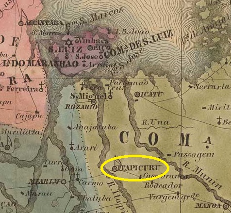
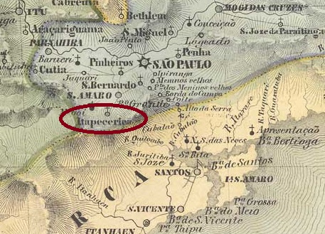
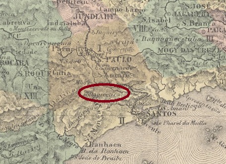
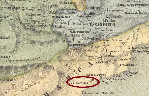
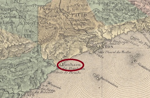
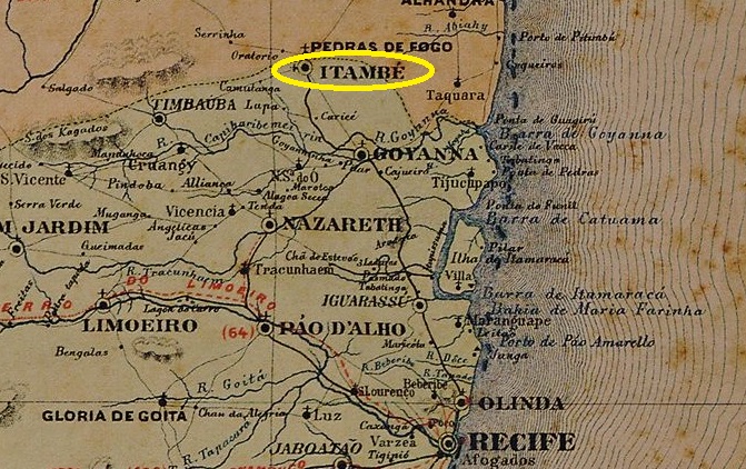
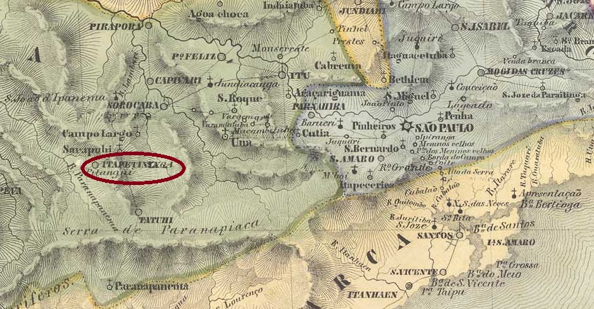
The Freguesia de N. Sra. dos Prazeres de Itapetininga (also spelt Itapeteninga), which belonged to the Vila de Sorocaba and was located 170 kilometres west of the later provincial capital of São Paulo, had existed since 1766 (other source: 1770). It became a vila in October 1770 (other source: January 1771) and was elevated to a town in March 1855. The name comes from the Tupi-Guarani and means place with dry stones.

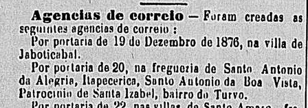
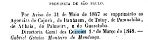
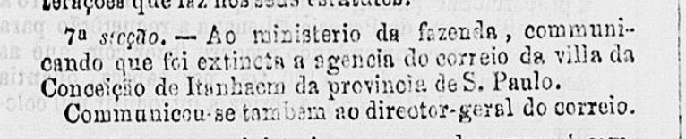
Three foundation dates have been found for the local post office. First in April 1828, as Nova Monteiro writes in Administrações e Agencias Postaes do Brasil Imperio (Brasil Filatelico/RJ, 1934-5; reprint SPP 1994-1999). Then in 1840 according to the philatelist Mário Celso Orsi Jr. and finally in 1844 according to the Directory of Imperial Post Offices (Tabella das Agencias do Correio do Imperio, Rio de Janeiro, 1885). It follows from this that the agency was closed at least once in the meantime. It is certain that a postal route between Sorocaba and Curitiba via Itapetininga was active in February 1831:

O Farol Paulistano, 15/03/1831

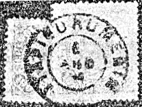
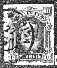
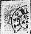
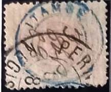
The oldest postmark to date is ISP-0620a (fig. Mário Celso Orsi Jr.):

ISP-0620a (MO) 1857-1868

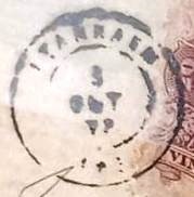
This was followed by the double circle ISP-0620b, also in blue, illustrated by P. Ayres in Catálogo de Carimbos Brasil-Império (S. Paulo, 1937, 1942):

ISP-0620b (P.A. p. 121) 1877-1883

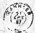
This was followed by the French type ISP-0620c (fig. Mário Orsi), also existent in blue:

ISP-0620c (MO) 1882-1890

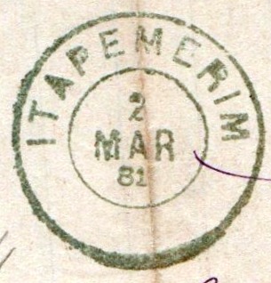
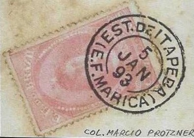
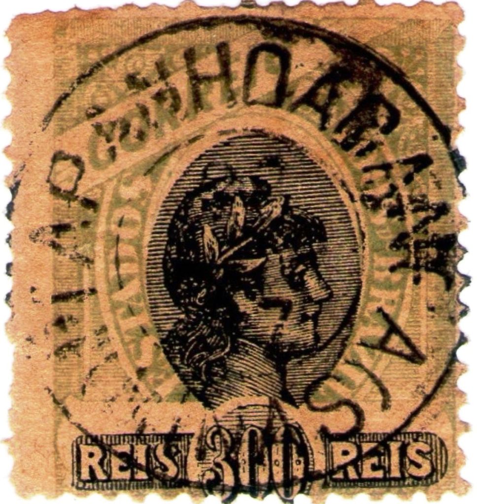
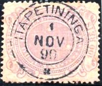
Towards the end of the Empire, ISP-0620d (ill. from the internet) appeared, also in blue and violet:

ISP-0620d (EB) 1889-1897

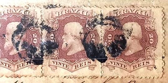
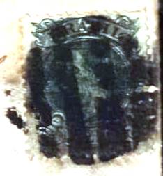
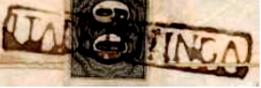
Two mute cancellations are known from the imperial Itapetininga:

1876ff (illus. Mário Orsi)
1882 (illustration from the Internet)
Atlas do Imperio do Brasil, 1868

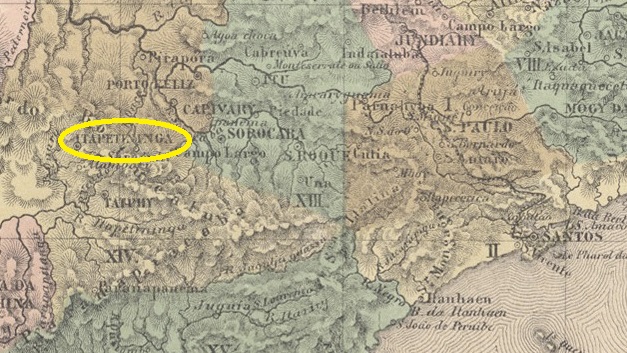
Seit 1766 (andere Quelle: 1770) bestand die Freguesia de N. Sra. dos Prazeres de Itapetininga (auch Itapeteninga geschrieben), die zur Vila de Sorocaba gehörte und 170 km westlich der späteren Provinzhauptstadt São Paulo lag. Sie wurde im Oktober 1770 (andere Quelle: Januar 1771) zur Vila und im März 1855 zur Stadt erhoben. Der Name stammt aus dem Tupi-Guarani und bedeutet Ort mit trockenen Steinen.

Für das örtliche Postamt wurden drei Gründungsdaten gefunden. Zuerst im April 1828, wie Nova Monteiro in Administrações e Agencias Postaes do Brasil Imperio (Brasil Filatelico/RJ, 1934-5; Nachdruck SPP 1994-1999) schreibt. Dann 1840 nach dem Philatelisten Mário Celso Orsi Jr. und schließlich 1844 nach dem Verzeichnis der kaiserlichen Postämter (Tabella das Agencias do Correio do Imperio, Rio de Janeiro, 1885). Daraus folgt, dass die Agentur zwischenzeitlich mindestens einmal geschlossen wurde. Sicher ist, dass im Februar 1831 eine Postroute zwischen Sorocaba und Curitiba über Itapetininga aktiv war:

O Farol Paulistano, 15.03.1831

Der bisher älteste Poststempel ist ISP-0620a (Abb. Mário Celso Orsi Jr.):

1882 (Abb. aus dem Internet)

Es folgte der Doppelkreis ISP-0620b, auch in blau, abgebildet von P. Ayres in Catálogo de Carimbos Brasil-Império (S. Paulo, 1937, 1942):

ISP-0620b (P.A. S. 121) 1877-1883

Danach kam der französische Typ ISP-0620c (Abb. Mário Orsi), auch in blau:

ISP-0620c (MO) 1882-1890

Gegen Ende des Kaiserreichs erschien auch ISP-0620d (Abb. aus dem Internet), den es auch in blau und violett gibt:

ISP-0620d (EB) 1889-1897

Vom kaiserlichen Itapetininga sind zwei stumme Stempel bekannt:

1876ff (Abb. Mário Orsi)
1882 (Abb. aus dem Internet)
Categories
Carimbologia H-L

Itapemerim, Espirito Santo (IES-0095)

Villiers de l’Ile Adam: Carta (…) da Provincia do Espirito Santo, 1850

Other names: Itapemirim

The Freguesia de N. Sra. do Patrocínio, founded in 1771, belonged to the Vila de Guarapary and was located on the south bank of the Itapemirim estuary, 100 kilometres south of the later provincial capital Vitória. In July 1813 it became the Freguesia de N.Sra. do Amparo do Itapemerim (now spelt Itapemirim) and two years later a Vila.

As Nova Monteiro writes in Administrações e Agencias Postaes do Brasil Imperio (Brasil Filatelico/RJ, 1934-5; reprint SPP 1994-1999), there had already been a post office there since October 1831.

The oldest postmark to date is IES-0095a, which was given the no. P-ES-02 in the RHM catalogue. However, the illustration shows clear differences to the specimens found, as can be seen in the picture (Fig. Wady Vidal):

IES-0095a (RHM P-ES-02 – recte WV) 1843ff-1854

This was followed by IES-0095b (ill. Henrique B. Ferreira in Catálogo ilustrado dos carimbos sobre os olhos-de-boi, Porto Alegre, 2017)

IES-0095b (HBF) 1843ff-1866ff

Then came IES-0095c, which was given the no. 1575 by P. Ayres in Catálogo de Carimbos Brasil-Império (S. Paulo, 1937, 1942), here in an illustration by Wady Vidal:

IES-0095c (P.A. 1575 – WV) 1850ff-1882

The last postmark of the imperial era is the double circle IES-0095d (illustration by Wady Vidal), which also exists in blue:

IES-0095d (WV) 1879-1896

Itapemerim also produced a mute cancellation in blue (fig. agenciaspostais.com.br):

1884 (PN)

Wady Vidal also shows a handwritten cancellation from the beginning of the Republic:

1890ff (WV)
Atlas do Imperio do Brasil, 1868

Andere Namen: Itapemirim

Die 1771 gegründete Freguesia de N. Sra. do Patrocínio gehörte zur Vila de Guarapary und lag am Südufer der Mündung des Itapemirim, 100 km südlich der späteren Provinzhauptstadt Vitória. Im Juli 1813 wurde sie zur Freguesia de N.Sra. do Amparo do Itapemerim (heute Itapemirim geschrieben) und zwei Jahre später zur Vila.

Wie Nova Monteiro in Administrações e Agencias Postaes do Brasil Imperio (Brasil Filatelico/RJ, 1934-5; Reprint SPP 1994-1999) schreibt, gab es dort bereits seit Oktober 1831 ein Postamt.

Der bisher älteste Poststempel ist IES-0095a, der im RHM-Katalog die Nr. P-ES-02 erhielt. Die Abbildung zeigt jedoch deutliche Unterschiede zu den gefundenen Exemplaren, wie man auf dem Bild (Abb. Wady Vidal) erkennen kann:

IES-0095a (RHM P-ES-02 – recte WV) 1843ff-1854

Es folgte IES-0095b (Abb. Henrique B. Ferreira in Catálogo ilustrado dos carimbos sobre os olhos-de-boi, Porto Alegre, 2017)

IES-0095b (HBF) 1843ff-1866ff

Danach kam IES-0095c, der von P. Ayres in Catálogo de Carimbos Brasil-Império (S. Paulo, 1937, 1942) die Nr. 1575 erhielt, hier in einer Abbildung von Wady Vidal:

IES-0095c (P.A. 1575 – WV) 1850ff-1882

Der letzte Poststempel der Kaiserzeit ist der Doppelkreis IES-0095d (Abb. Wady Vidal), den es auch in blau gibt:

IES-0095d (WV) 1879-1896

Aus Itapemerim kommt auch ein stummer Stempel in blau (Abb. agenciaspostais.com.br):

1884 (PN)

Wady Vidal zeigt auch eine handschriftliche Entwertung vom Beginn der Republik:

1890ff (WV)
Categories
Carimbologia H-L

Itapecuru-Merim, Maranhão (IMA-0310)

Atlas do Imperio do Brasil, 1868

Other names: Itapicuru/Itapucuru-Mirim

The Freguesia de N. Sra. das Dores do Itapecuru-Merim, formerly Itapucuru, sometimes also spelt Itapicuru, had existed since September 1801. At that time it belonged to Vila de S. Luis and was located 120 kilometres south of it on the east bank of the Itapecuru-Mirim. It became a vila in October 1818 and a town in July 1870. The name, now written Itapecuru Mirim, comes from the Tupi and means stone warehouse.

The local post office was opened at least twice. First in February 1820, as Nova Monteiro writes in Administrações e Agencias Postaes do Brasil Imperio (Brasil Filatelico/RJ, 1934-5; reprint SPP 1994-1999). Then again in December 1830, as can be seen from the postal report (Relatorio dos Correios) of 1886.

The oldest postmark to date, IMA-0310a, was found on Bull’s-eye issues from 1843 and appears to be similar to other earlier postmarks from this province, as the reconstruction by Henrique B. Ferreira’s Catálogo ilustrado dos carimbos sobre os olhos-de-boi (Porto Alegre, 2017) shows:

IMA-0310a (HBF) 1844

Then came IMA-0310b (ill. Walter Sonnenberg):

IMA-0310b (WS) 1850ff-1883

This was followed by the circle cancellation IMA-0310c (ill. R. Koester in Carimbologia XXIV):

IMA-0310c (RK) 1879-1883

Towards the end of the Empire, IMA-0310d also appeared (fig. Koester, op. cit.):

IMA-0310d (RK) 1889-1896
Villiers de l’Ile Adam: Carta (…) da Provincia do Maranhão, 1850

Andere Namen: Itapicuru/Itapucuru-Mirim

Seit September 1801 bestand die Freguesia de N. Sra. das Dores do Itapecuru-Merim, früher Itapucuru, manchmal auch Itapicuru geschrieben. Sie gehörte damals zu Vila de S. Luis und lag 120 km südlich davon am Ostufer des Itapecuru-Mirim. Im Oktober 1818 wurde es zur Vila und im Juli 1870 zur Stadt erhoben. Der Name (heute Itapecuru Mirim geschrieben) stammt aus dem Tupi und bedeutet Steinlager.

Das örtliche Postamt wurde mindestens zweimal eröffnet. Zuerst im Februar 1820, wie Nova Monteiro in Administrações e Agencias Postaes do Brasil Imperio (Brasil Filatelico/RJ, 1934-5; Nachdruck SPP 1994-1999) schreibt. Dann wieder im Dezember 1830, wie aus dem Postbericht (Relatorio dos Correios) von 1886 hervorgeht.

Der bisher älteste Poststempel IMA-0310a wurde auf Ochsenaugen-Ausgaben von 1843 gefunden und scheint anderen früheren Stempeln aus dieser Provinz ähnlich zu sein, wie die Rekonstruktion von Henrique B. Ferreiras Catálogo ilustrado dos carimbos sobre os olhos-de-boi (Porto Alegre, 2017) zeigt:

IMA-0310a (HBF) 1844

Dann kam IMA-0310b (Abb. Walter Sonnenberg):

IMA-0310b (WS) 1850ff-1883

Es folgte der Kreisstempel IMA-0310c (Abb. R. Koester in Carimbologia XXIV):

IMA-0310c (RK) 1879-1883

Gegen Ende des Kaiserreichs erschien auch IMA-0310d (Abb. Koester, op. cit.):

IMA-0310d (RK) 1889-1896
Categories
Carimbologia H-L

Itapecerica, São Paulo (ISP-0615)

Villiers de l’Ile Adam: Carta (…) da Provincia de São Paulo, 1847

Other names: Itapecerica da Serra (1944)

The history of the village begins in November 1827, when a colony for German immigrants was founded by imperial decree 35 kilometres southwest of the provincial capital of São Paulo. In February 1841, it became the Freguesia de N. Sra. dos Prazeres de Itapecerica, which belonged to the Vila de Sto. Amaro. In May 1877 Itapecerica became a Vila and in December 1906 a town, which since November 1944 has borne the name Itapecerica da Serra (on the mountain), probably to avoid confusion with the town of the same name in Minas Gerais. The Tupi-guarani term means slippery stone.

As reported in the regional press, there had been a post office there since December 1876:

Correio Paulistano, 05.01.1877

The postmark probably did not arrive in time, as the stamps were cancelled by hand, as shown in the illustration from the Fuad Ferreira Fo. collection:

1883ff (FF)

It was not until the 1880s that the French type ISP-0615a (Marcio Duarte collection) was used:

ISP-0615a (MD) 1885-1905
Atlas do Imperio do Brasil, 1868

Andere Namen: Itapecerica da Serra (1944)

Die Geschichte des Ortes beginnt im November 1827, als auf kaiserlichen Erlass 35 km südwestlich der Provinzhauptstadt São Paulo eine Kolonie für deutsche Einwanderer gegründet wurde. Im Februar 1841 wurde daraus die Freguesia de N. Sra. dos Prazeres de Itapecerica, die zur Vila de Sto. Amaro gehörte. Im Mai 1877 wurde Itapecerica eine Vila und im Dezember 1906 eine Stadt, die seit November 1944 den Namen Itapecerica da Serra (am Berg) trägt, wahrscheinlich um Verwechslungen mit dem gleichnamigen Ort in Minas Gerais zu vermeiden. Der Begriff aus dem Tupi-guarani bedeutet rutschiger Stein.

Wie die regionale Presse berichtete, gab es dort seit Dezember 1876 ein Postamt:

Correio Paulistano, 05.01.1877

Vermutlich traf der Poststempel nicht rechtzeitig ein, denn die Marken wurden von Hand entwertet, wie die Abbildung aus der Sammlung Fuad Ferreira Fo.:

1883ff (FF)

Erst in den 1880er Jahren wurde der französische Typ ISP-0615a (Sammlung Marcio Duarte) verwendet:

ISP-0615a (MD) 1885-1905

Categories
Carimbologia H-L

Itapeba (train station/Bahnhof), Rio de Janeiro (IRJ-2305)

Estrada de Ferro de Maricá

Itapeba station was opened in July 1889 by the railway company E.F. de Maricá (Cabo Frio branch line) and was located on the northern shore of the lake in the Município de Maricá, 50 km east of the capital Rio de Janeiro. The line was in operation until 1964, but today there are neither tracks nor a railway station. The name from the Tupi-guarani means flat stone.

In October 2008 (Photo: Cleiton Pieruccini, on estacoesferroviarias.com.br)

According to the postal bulletin (Boletim Postal No. 7, November 1889), there had been a post office there since October 1889, which, according to Paulo Novaes (agenciaspostais.com.br), was closed in December 1896, reopened in January 1898 and finally closed around 1907.

The oldest postmark is IRJ-2305a (collect. Márcio Protzner):

IRJ-2305a (MP) 1891-1895
agenciaspostais.com.br

Der Bahnhof Itapeba wurde im Juli 1889 von der Eisenbahngesellschaft E.F. de Maricá (Zweigbahn Cabo Frio) eröffnet und lag am Nordufer des Sees im Município de Maricá, 50 km östlich der Hauptstadt Rio de Janeiro. Die Strecke war bis 1964 in Betrieb, heute gibt es weder Gleise noch einen Bahnhof. Der Name aus dem Tupi-guarani bedeutet flacher Stein.

Im Oktober 2008 (Foto: Cleiton Pieruccini, auf estacoesferroviarias.com.br)

Wie aus dem Postbulletin (Boletim Postal Nr. 7, November 1889) hervorgeht, gab es dort seit Oktober 1889 ein Postamt, das laut Paulo Novaes (agenciaspostais.com.br) im Dezember 1896 geschlossen, im Januar 1898 wiedereröffnet und um 1907 endgültig geschlossen wurde.

Der älteste Poststempel ist IRJ-2305a (Samml. Márcio Protzner):

IRJ-2305a (MP) 1891-1895
Categories
Carimbologia H-L

Itaparica, Bahia (IBA-0405)

Atlas do Imperio do Brasil, 1868

The Freguesia de Santissimo Sacramento de Itaparica was founded in January 1815, belonged to the city of Salvador da Bahia and was idyllically situated on the island of Itaparica in the Bay of All Saints, 30 kilometres west of the capital. Itaparica became a vila in October 1831 and a city in October 1890. The term comes from the Tupi-Guarani and means stone wall.

Nova Monteiro writes in Administrações e Agencias Postaes do Brasil Imperio (Brasil Filatelico/RJ, 1934-5; reprint SPP 1994-1999) that there had been a post office there since October 1858. This is confirmed by the following report from the postal General Directorate:

Relatorio da Directoria Geral dos Correios, 1858

The only imperial postmark to date is IBA-0405b (fig. R. Koester in Carimbologia XXIV):

IBA-0405b (RK) 1877ff-1895
Villiers de l’Ile Adam: Carta (…) da Provincia da Bahia , 1848

Die Freguesia de Santissimo Sacramento de Itaparica wurde bereits im Januar 1815 gegründet, gehörte zur Stadt Salvador da Bahia und lag idyllisch auf der Insel Itaparica in der Allerheiligenbucht, 30 km westlich der Hauptstadt. Itaparica wurde im Oktober 1831 zur Vila und im Oktober 1890 zur Stadt erhoben. Der Begriff stammt aus dem Tupi-Guarani und bedeutet Steinmauer.

Nova Monteiro schreibt in Administrações e Agencias Postaes do Brasil Imperio (Brasil Filatelico/RJ, 1934-5; Reprint SPP 1994-1999), dass es dort seit Oktober 1858 ein Postamt gab. Dies wird durch den folgenden Bericht der Generaldirektion der Post bestätigt:

Relatorio da Directoria Geral dos Correios, 1858

Der bisher einzige kaiserliche Poststempel ist IBA-0405b (Abb. R. Koester in Carimbologia XXIV):

IBA-0405b (RK) 1877ff-1895

Categories
Carimbologia H-L

Itapanhoacanga, Minas Gerais (IMG-3675)

Provincia de Minas Geraes, 1873

Other names: Tapanhoacanga

Since December 1880, Itapanhoacanga was a distrito of the Vila do Serro, located 300 kilometres north of the provincial capital Ouro Preto. In October 1881 it was elevated to the Freguesia de S. José de Itapanhoacanga, which has been a distrito of the Município de Alvorada de Minas since December 1962. The name Tupi-guarani, which sounds strange even to Brazilian ears, means negro head stone and refers to the abundant iron ore available at the time.

The Rio press reports that there had been a post office there since November 1881:

Jornal do Commercio/RJ, 08/11/1881

The only postmark from the 19th century to date, IMG-3675b (illustration by Claudio Coelho), already shows dates from the Republic:

IMG-3675b (CC) 1897-1905
Estado de Minas Geraes, 1910

Andere Namen: Tapanhoacanga

Seit Dezember 1880 war Itapanhoacanga ein Distrito der Vila do Serro, 300 km nördlich der Provinzhauptstadt Ouro Preto gelegen. Im Oktober 1881 erfolgte die Erhebung zur Freguesia de S. José de Itapanhoacanga, die seit Dezember 1962 ein Distrito des Município de Alvorada de Minas ist. Der selbst für brasilianische Ohren merkwürdig klingende Name der Tupi-guarani bedeutet Negerkopfstein und bezieht sich auf das damals reichlich vorhandene Eisenerz.

Die Presse von Rio berichtet, dass es dort seit November 1881 ein Postamt gab:

Jornal do Commercio/RJ, 08.11.1881

Der bisher einzige Poststempel aus dem 19. Jahrhundert IMG-3675b (Abb. Claudio Coelho) zeigt bereits Daten aus der Republik:

IMG-3675b (CC) 1897-1905
Categories
Carimbologia H-L

Itapacoroy / Itapocoroy, Santa Catarina (ISC-0135)

Villiers de l’Ile Adam: Carta (…) da Provincia de Santa Catarina, 1848

Other names: Penha de Itapocoroí, Penha (1938)

The Freguesia de N. Sra. da Penha do Itapocoroy has existed since March 1839, it belonged to the Vila de S. Francisco and was a nautic base (armação) on the beach, 120 km north of the provincial capital Desterro (today: Florianópolis). In April 1859 the Freguesia was transferred to the Vila de Itajaí, in March 1938 the place name was simplified to Distrito de Penha. Penha has been an independent municipality since June 1958.

Two dates have been found for the foundation of the local post office. The first is around 1840, as can be seen in a report from the Imperial Ministry from May of the following year:

Relatorio do Ministerio do Imperio, 05/1841

The agency was closed by 1856 at the latest, as it is no longer mentioned in the postal guide (Guia do Correio do Brasil) of 1857. The second opening followed the decision of September 1875, as R. Koester (Carimbologia XXIV) writes. The only imperial postmark to date is ISC-0135b (fig. Koester, op. cit.):

ISC-0135b (RK) 1882ff
Atlas do Imperio do Brasil, 1868

Andere Namen: Penha de Itapocoroí, Penha (1938)

Seit März 1839 bestand die Freguesia de N. Sra. da Penha do Itapocoroy, sie gehörte zur Vila de S. Francisco und war ein Schifffahrts-Stützpunkt (armação) am Strand, 120 km nördlich der Provinzhauptstadt Desterro (heute: Florianópolis) Im April 1859 ging die Freguesia an die Vila de Itajaí über, im März 1938 wurde der Ortsname in Distrito de Penha vereinfacht. Seit Juni 1958 ist Penha ein eigenständiges Munizip.

Für die Gründung des örtlichen Postamtes wurden zwei Daten gefunden. Zum ersten Mal um 1840, wie aus einem Bericht des kaiserlichen Ministeriums vom Mai des folgenden Jahres hervorgeht:

Relatorio do Ministerio do Imperio, 05/1841

Die Agentur wurde spätestens 1856 geschlossen, da sie im Postführer (Guia do Correio do Brasil) des folgenden Jahres nicht mehr erwähnt wird. Die zweite Eröffnung folgte auf den Beschluss vom September 1875, wie R. Koester (Carimbologia XXIV) schreibt. Der bisher einzige kaiserliche Poststempel ist ISC-0135b (Abb. Koester, op. cit.):

ISC-0135b (RK) 1882ff

Categories
Carimbologia H-L

Itanhaem, São Paulo (ISP-0610)

Villiers de l’Ile Adam: Carta (…) da Provincia de São Paulo, 1847

This place is one of the oldest in Brazil. The settlement was founded as early as April 1532 at the mouth of the Itanhaém River into the Atlantic Ocean, 110 kilometres south of the later provincial capital of São Paulo, which was elevated to the Freguesia de N. Sra. da Conceição do Itanhaém in 1549 and to a Vila in April 1561. The name of the municipality was shortened to Itanhaém in November 1906 and it became a town in December 1906.

Three periods of operation for the local post office in the Empire have been established, although it is still unknown when the first one began. It ended in May 1847, according to the report of the Ministry of the Empire:

Relatorio do Ministerio do Imperio, 1847

Nova Monteiro writes in Administrações e Agencias Postaes do Brasil Imperio (Brasil Filatelico/RJ, 1934-5; reprint SPP 1994-1999) about a reopening of the agency in February 1849, which was closed again a good ten years later:

Expediente do Ministerio do Imperio, 31/12/1859

The third operating period began in 1869, as can be seen from the list of imperial post offices (Tabella das Agencias do Correio do Imperio, Rio de Janeiro, 1885). The first postmark has not yet been found; of the second, the French type ISP-0610b (collect. Fuad Ferreira Fo.), only one specimen from 1872 is known:

ISP-0610b (FF) 1872

There is also a mute cancellation on the same cover:

1872 (FF)

The following cancel is also rare, ISP-0610c was introduced by R. Koester in Carimbologia XXIV:

ISP-0610c (RK) 1887
Atlas do Imperio do Brasil, 1868

Dieser Ort ist einer der ältesten Brasiliens. Bereits im April 1532 wurde die Siedlung an der Mündung des Flusses Itanhaém in den Atlantik gegründet, 110 km südlich der späteren Provinzhauptstadt São Paulo, die 1549 zur Freguesia de N. Sra. da Conceição do Itanhaém und im April 1561 zur Vila erhoben wurde. Der Name der Gemeinde wurde im November 1906 auf Itanhaém verkürzt, seit Dezember 1906 ist es eine Stadt.

Drei Betriebsperioden für das örtliche Postamt im Kaiserreich festgestellt, wobei noch unbekannt ist, wann die erste begann. Sie endete im Mai 1847, wie aus dem Bericht des Reichsministeriums hervorgeht:

Relatorio do Ministerio do Imperio, 1847

Nova Monteiro schreibt in Administrações e Agencias Postaes do Brasil Imperio (Brasil Filatelico/RJ, 1934-5; Nachdruck SPP 1994-1999) über eine Wiedereröffnung der Agentur im Februar 1849, die gut zehn Jahre später wieder geschlossen wurde:

Expediente do Ministerio do Imperio, 31.12.1859

Die dritte Betriebsperiode begann 1869, wie aus dem Verzeichnis der kaiserlichen Postämter (Tabella das Agencias do Correio do Imperio, Rio de Janeiro, 1885). Der erste Poststempel wurde noch nicht gefunden, vom zweiten, dem französischen Typ ISP-0610b (Samml. Fuad Ferreira Fo.) ist nur ein Exemplar aus dem Jahr 1872 bekannt:

ISP-0610b (FF) 1872

Auf demselben Beleg befindet sich auch ein stummer Stempel:

1872 (FF)

Der folgende Stempel ist ebenfalls selten, ISP-0610c wurde von R. Koester in Carimbologia XXIV vorgestellt:

ISP-0610c (RK) 1887
Categories
Carimbologia H-L

Itambé, Pernambuco (IPE-0330)

Carta Corographica da Provincia de Pernambuco, 1880

Other names: També (1938-1975)

The Freguesia de N. Sra. do Desterro do Itambé had existed since January 1789. It belonged to the Vila de Goyanna and was located on the provincial border with Paraíba, opposite Pedras de Fogo, 90 kilometres north of the capital Recife. It was declared a vila in May 1867 and a town in February 1879, which was called També between 1938 and 1975, before the old place name returned.

According to the list of imperial post offices (Tabella das Agencias do Correio do Imperio, Rio de Janeiro, 1885), there had been a post office there since 1876. The oldest postmark to date is the French type IPE-0330a (coll. Fuad Ferreira Fo.), which also exists in blue:

IPE-0330a (FF) 1882ff-1890

A mute cancellation (Fuad Ferreira Fo. Coll.) is also known from there:

1882ff (FF)
Atlas do Imperio do Brasil, 1868

Andere Namen: També (1938-1975)

Seit Januar 1789 bestand die Freguesia de N. Sra. do Desterro do Itambé, sie gehörte der Vila de Goyanna und lag an der Provinzgrenze zu Paraíba, gegenüber Pedras de Fogo, 90 km nördlich der Hauptstadt Recife. Sie wurde im Mai 1867 zur Vila und im Februar 1879 zu einer Stad erklärt, die zwischen 1938 und 1975 També hieß, bevor der alte Ortsname zurückkehrte.

Laut Verzeichnis der kaiserlichen Postämter (Tabella das Agencias do Correio do Imperio, Rio de Janeiro, 1885) gab es dort ein Postamt seit 1876. Der bisher älteste Poststempel ist der französiche Typ IPE-0330a (Samml. Fuad Ferreira Fo.), den es auch in Blau gibt:

IPE-0330a (FF) 1882ff-1890

Von dort ist auch eine stumme Abstempelung (Samml. Fuad Ferreira Fo.) bekannt:

1882ff (FF)