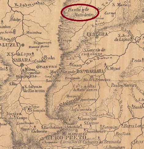
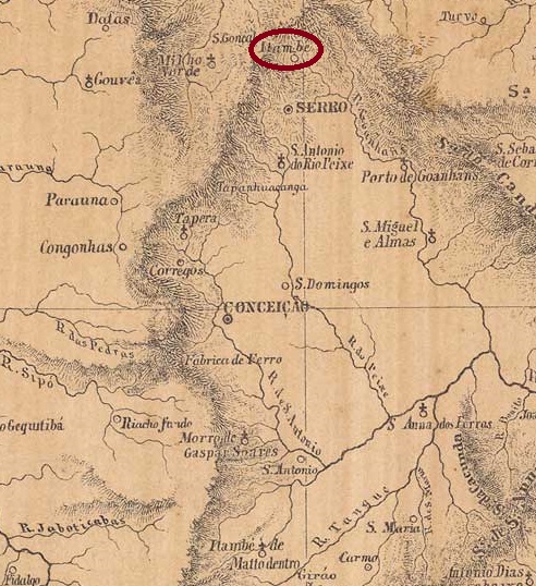
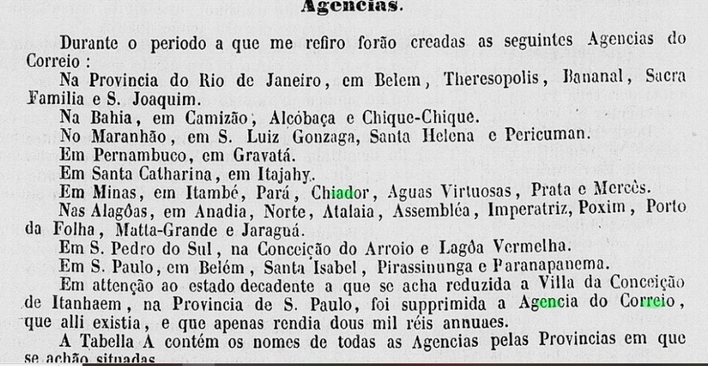
The Freguesia de N. Sra. da Oliveira de Itambé, founded in April 1841, belonged to the Vila de Conceição do Matto Dentro and was located on the south bank of the Rio Preto, 160 kilometres north of the provincial capital Ouro Preto. It was assigned to the newly founded municipality of Santa Maria de Itabira as Distrito de Itacururu in December 1943 and became the Município de Itambé do Mato Dentro in March 1963.
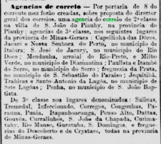
According to the press in Rio, the local post office was created in July 1859:
Jornal do Commercio/RJ, 16/07/1859
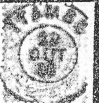
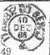
The directory of imperial post offices (Tabella das Agencias do Correio do Imperio, Rio de Janeiro, 1885) gives 1877 as the year of foundation, which indicates a reopening. The oldest cancel to date is IMG-1365b (fig. R. Koester, in Carimbologia XXIII):
IMG-1365b (RK) 1889-1895Provincia de Minas Geraes, 1873
Andere Namen: Itaimbé, Itacururu
Die im April 1841 gegründete Freguesia de N. Sra. da Oliveira de Itambé gehörte zur Vila de Conceição do Matto Dentro und lag am Südufer des Rio Preto, 160 km nördlich der Provinzhauptstadt Ouro Preto. Sie wurde im Dezember 1943 als Distrito de Itacururu der neu gegründeten Gemeinde Santa Maria de Itabira zugeordnet und im März 1963 zum Município de Itambé do Mato Dentro.
Wie der Presse in Rio zu entnehmen ist, gab es seit Juli 1859 ein Postamt am Ort:
Jornal do Commercio/RJ, 16.07.1859
Das Verzeichnis der kaiserlichen Postämter (Tabella das Agencias do Correio do Imperio, Rio de Janeiro, 1885) gibt als Gründungsjahr 1877 an, was auf eine Wiedereröffnung hindeutet. Der bisher älteste Stempel ist IMG-1365b (Abb. R. Koester, in Carimbologia XXIII):
Since 1836 the village was a district of Vila do Principe (today: Serro), near the south bank of the Guanhães, 350 km north of the provincial capital Ouro Preto. In November 1875 it became the Freguesia de Sto. Antonio do Itambé and in December 1962 it was elevated to the Município de Sto. Antonio do Itambé in December 1962. The name Itambé (also Itaimbé) comes from the Tupi-guarani and means pointed stone.
According to the Rio press, there had been a post office there since November 1881:
Jornal do Commercio/RJ, 12/11/1881
The imperial postmark is IMG-3670a (ill. by R. Koester in Carimbologia XXIII):
IMG-3670a (RK) 1888
Koester (op. cit.) also shows the postmark with the imperial seal IMG-3670b:
IMG-3670b (RK)Provincia de Minas Geraes, 1873
Andere Namen: Santo Antonio do Itambé
Seit 1836 war der Ort ein Distrito von Vila do Principe (heute: Serro), nahe dem Südufer des Guanhães, 350 km nördlich der Provinzhauptstadt Ouro Preto. Im November 1875 wurde es zur Freguesia de Sto. Antonio do Itambé und im Dezember 1962 zum Município de Sto. Antonio do Itambé erhoben. Der Name Itambé (auch Itaimbé) stammt aus dem Tupi-guarani und bedeutet spitzer Stein.
Wie aus der Presse von Rio hervorgeht, gab es dort seit November 1881 ein Postamt:
Jornal do Commercio/RJ, 12.11.1881
Der kaiserliche Poststempel ist IMG-3670a (Abb. R. Koester in Carimbologia XXIII):
IMG-3670a (RK) 1888
Koester (op. cit.) zeigt auch den Stempel mit dem kaiserlichen Siegel IMG-3670b:
Villiers de l’Ile Adam: Carta (…) da Provincia de Minas Geraes, 1849
Other names: Boa Vista, Capella Nova
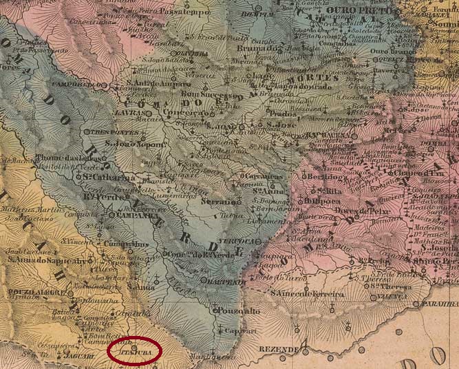
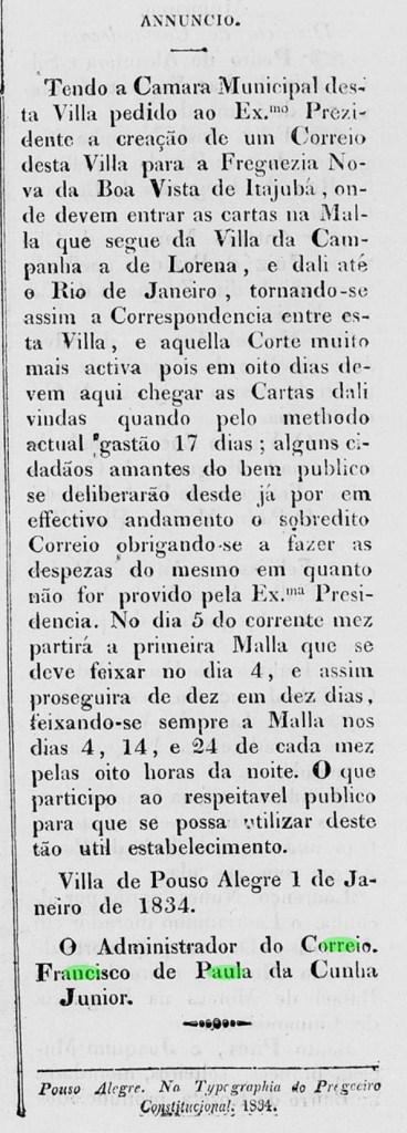
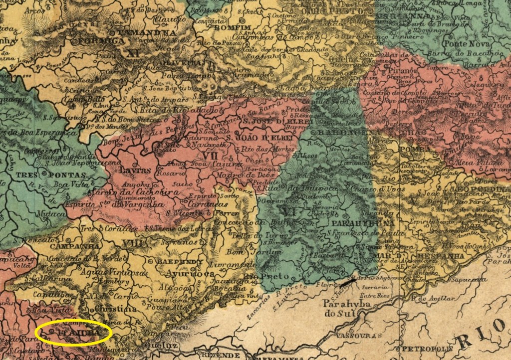
The settlement of Boa Vista do Itajubá was founded in March 1819. It belonged to the Freguesia de Descoberto (today the município de Delfim Moreira) in the Vila de Campanha area and was located on the north bank of the Sapucaí, 420 kilometres southwest of the later provincial capital Ouro Preto. In July 1832 it became the Freguesia de N. Sra. da Conceição da Boa Vista do Itajubá, in September 1848 it was elevated to a Vila and in October 1862 to a town. The name, which comes from the Tupi-guarani, can mean both yellow stone (ita + juba) and waterfall on the river of stones (ita + jybá).
Two creation dates have been found for the local post office. The first was around January 1834, according to the regional press:
O Recopilador Mineiro, 04/01/1834
Then again in October 1856, as Nova Monteiro writes in Administrações e Agencias Postaes do Brasil Imperio (Brasil Filatelico/RJ, 1934-5; reprint SPP 1994-1999). The two oldest postmarks, IMG-1355a (fig. R. Koester in Carimbologia XXIII) and IMG-1355b (dto.), date from the agency’s first period of operation:
IMG-1355a (RK) 1835IMG-1355b (RK) 1844ff
Around the time of the reopening, the stamps were initially cancelled by hand, as Koester (op. cit.) shows:
1850ff (RK)
It was not until the 1870s that the circular cancellation IMG-1355c (fig. P. Ayres in Catálogo de Carimbos Brasil-Império, S. Paulo, 1937, 1942) was used:
IMG-1355c (P.A.p. 121) 1879-1884
At this time Itajubá was already a town, as the following cancel IMG-1355d (fig. P. Ayres, op. cit.) proudly points out:
IMG-1355d (P.A. p. 121) 1885-1901
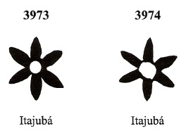
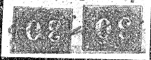
James Dingler and Klerman W. Lopes have listed two mute cancellations from Itajubá in Mute Cancellations of the Brazil Empire / Carimbos Mudos do Brasil Império (Brazil Philatelic Association, Rio de Janeiro, 2000):
BPA 3973 (P.A. 734, 1866ff-1879, also in blue) – 3974Atlas do Imperio do Brasil, 1868
Andere Namen: Boa Vista, Capella Nova
Die Siedlung Boa Vista do Itajubá entstand im März 1819. Sie gehörte zur Freguesia de Descoberto (heute der Município de Delfim Moreira), im Gebiet der Vila de Campanha und lag am Nordufer des Sapucaí, 420 km südwestlich der späteren Provinzhauptstadt Ouro Preto. Im Juli 1832 wurde es zur Freguesia de N. Sra. da Conceição da Boa Vista do Itajubá, im September 1848 zur Vila und im Oktober 1862 zur Stadt erhoben. Der aus dem Tupi-guarani stammende Name kann sowohl gelber Stein (ita + juba) als auch Wasserfall am Fluss der Steine (ita + jybá) bedeuten.
Für das örtliche Postamt wurden zwei Gründungsdaten gefunden. Die erste um Januar 1834, wie aus der regionalen Presse hervorgeht:
O Recopilador Mineiro, 04.01.1834
Dann wieder im Oktober 1856, wie Nova Monteiro in Administrações e Agencias Postaes do Brasil Imperio (Brasil Filatelico/RJ, 1934-5; Nachdruck SPP 1994-1999) schreibt. Die beiden ältesten Stempel, IMG-1355a (Abb. R. Koester in Carimbologia XXIII) und IMG-1355b (dto.), stammen wohl aus der ersten Betriebsperiode der Agentur:
IMG-1355a (RK) 1835IMG-1355b (RK) 1844ff
Um die Zeit der Wiedereröffnung wurden die Marken zunächst von Hand entwertet, wie Koester (op. cit.) zeigt:
1850ff (RK)
Erst in den 1870er Jahren wurde der Rundstempel IMG-1355c (Abb. P. Ayres in Catálogo de Carimbos Brasil-Império, S. Paulo, 1937, 1942) verwendet:
IMG-1355c (P.A. S. 121) 1879-1884
Zu diesem Zeitpunkt war Itajubá bereits eine Stadt, worauf der folgende Stempel IMG-1355d (Abb. P. Ayres, op. cit.) stolz hinweist:
IMG-1355d (P.A. S. 121) 1885-1901
James Dingler und Klerman W. Lopes haben in Mute Cancellations of the Brazil Empire / Carimbos Mudos do Brasil Império (Brazil Philatelic Association, Rio de Janeiro, 2000) zwei stumme Abstempelungen aus Itajubá aufgelistet:
BPA 3973 (P.A. 734, 1866ff-1879, auch in Blau) – 3974
Villiers de l’Ile Adam: Carta (…) da provincia de Santa Catharina, 1848
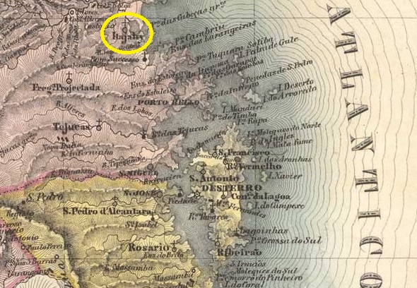
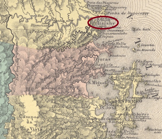
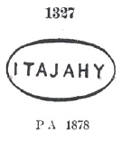
In 1820, the fisher’s colony of Itajahy was founded on the south bank of the Itajahy estuary in the Atlantic Ocean, 100 kilometres north of the future provincial capital of Desterro (now Florianópolis). Ten years later, the colony became Curato of the Vila de S. Francisco and in August 1833 Freguesia do Santissimo Sacramento de Itajahy. In April 1859 it became a Vila and in July 1877 a town, now spelled Itajaí.
Two dates have been found for the foundation of the local post office. The first is in February 1841, as R. Koester writes in Carimbologia XXIII and is confirmed by the report of the Imperial Ministry (Relatorio do Ministerio do Imperio):
Relatorio do Ministerio do Imperio , May 1841
The agency was closed by 1856, as it is no longer mentioned in the postal guide (Guia do Correio do Brasil, Rio de Janeiro 1857), and reopened in 1859, as can be seen from the report of the Postal Directorate (Directoria Geral dos Correios) of March 1860:
Relatório DGC, in Relatorio do Ministerio do Imperio, March 1860
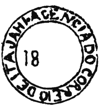
The oldest postmark to date is ISC-0130a, which was probably used in the first period of operation of the post office and is recorded in Cicero A. Almeida’s Carimbos Postais – século XIX (Rio de Janeiro, 1989) with the number 744:
ISC-0130a (MPT 744)
Then came ISC-0130b, which is listed in the P. Ayres’ Catálogo de Carimbos Brasil-Império (S. Paulo, 1937, 1942) under no. 1327:
ISC-0130b (P.A. 1327) 1877ff-1879
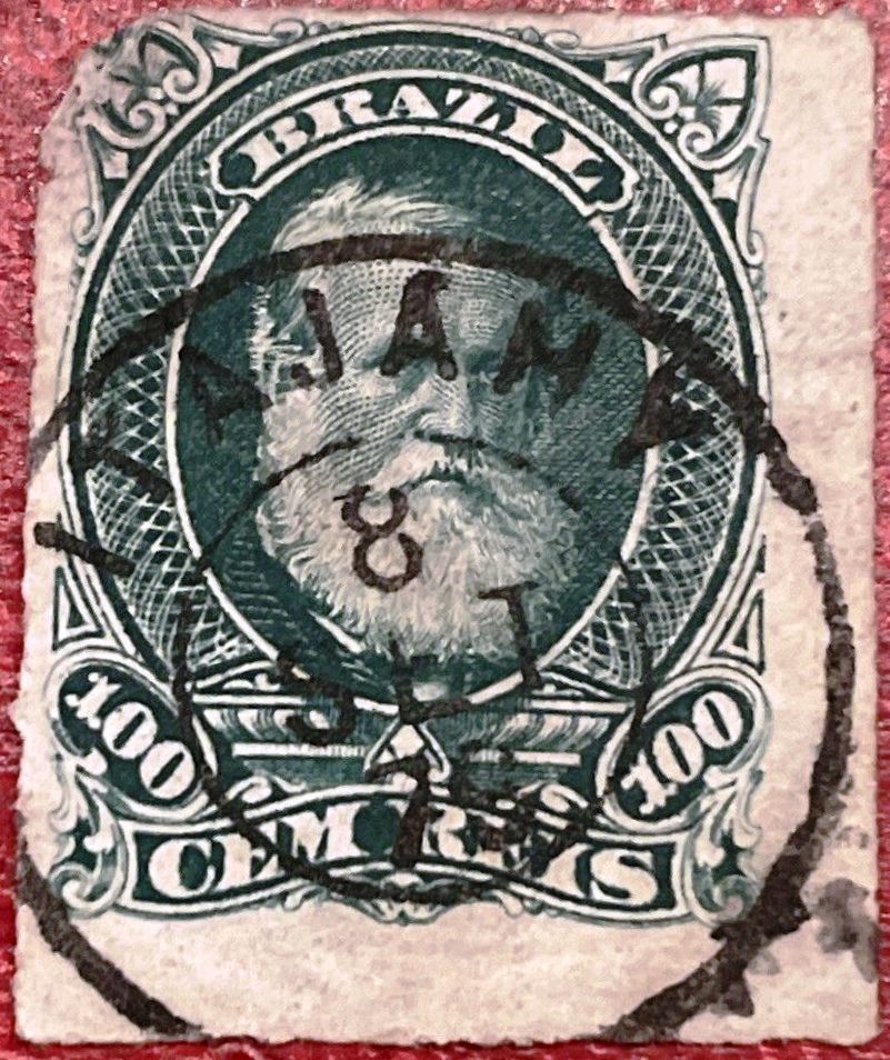
This was followed by the circle cancellation ISC-0130c (illustration from the Internet):
ISC-0130c (EB) 1876ff-1887
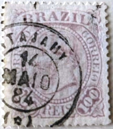
Towards the end of the Empire, two further postmarks also appeared, initially the French type ISC-0130d (illustration from the Internet):
ISC-0130d (EB) 1884-1887
Then also ISC-0130e (illustration from the Internet):
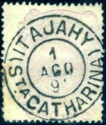
ISC-0130e (EB) 1889-1897
R. Koester showed in Carimbologia also the cancel with the imperial seal ISC-0130f:
ISC-0130f (RK)Atlas do Imperio do Brasil, 1868
1820 wurde am Südufer der Mündung des Itajahy in den Atlantik, 100 km nördlich der späteren Provinzhauptstadt Desterro (heute Florianópolis), die Fischerkolonie Itajahy gegründet. Zehn Jahre später wurde die Kolonie Curato der Vila de S. Francisco und im August 1833 Freguesia do Santissimo Sacramento de Itajahy. Im April 1859 wurde sie zur Vila und im Juli 1877 zur Stadt erhoben.
Für die Gründung des örtlichen Postamtes wurden zwei Daten gefunden. Zum ersten Mal im Februar 1841, wie R. Koester in Carimbologia XXIII schreibt und durch den Bericht des kaiserlichen Ministeriums (Relatorio do Ministerio do Imperio) bestätigt wird:
Relatorio do Ministerio do Imperio , Mai 1841
Die Agentur wurde bis 1856 geschlossen, da sie im Postführer (Guia do Correio do Brasil, Rio de Janeiro 1857) nicht mehr erwähnt wird, und 1859 wieder eröffnet, wie aus dem Bericht der Postdirektion (Directoria Geral dos Correios) vom März 1860 hervorgeht:
Relatório DGC, in Relatorio do Ministerio do Imperio, März 1860
Der bisher älteste Poststempel ist ISC-0130a, der vermutlich in der ersten Betriebsperiode des Postamts verwendet wurde und im Cicero A. Almeidas Carimbos Postais – século XIX (Rio de Janeiro, 1989) die Nummer 744 erhielt:
ISC-0130a (MPT 744)
Danach kam ISC-0130b, der im P. Ayres’ Catálogo de Carimbos Brasil-Império (S. Paulo, 1937, 1942) unter Nr. 1327 aufgeführt wird:
ISC-0130b (P.A. 1327) 1877ff-1879
Es folgte der Kreisstempel ISC-0130c (Abb. aus dem Internet):
ISC-0130c (EB) 1876ff-1887
Gegen Ende des Kaiserreichs erschienen auch zwei weitere Poststempel, zunächst der französischer Typ ISC-0130d (Abb. aus dem Internet):
ISC-0130d (EB) 1884-1887
Dann auch ISC-0130e (Abb. aus dem Internet):
ISC-0130e (EB) 1889-1897
R. Koester zeigte in Carimbologia noch den Stempel mit dem kaiserlichen Siegel ISC-0130f:
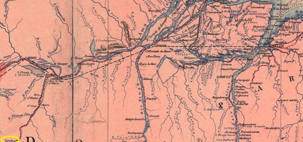
Around 1810, a harbour was built on the left bank of the Tapajós near the settlement of Pinhel, 900 km southwest of the later provincial capital of Belém do Pará. In 1853, the settlement created there was incorporated into the Freguesia de Boim, which belonged to the Vila de Santarém. In December 1856, it was elevated to Vila de Sant’Anna de Itaituba, which was declared a town in March 1900. In December 1930, it was downgraded to a district and assigned directly to the state of Pará. The Município de Itaituba has existed again since October 1935. The word comes from the Tupi language and means rivers rich in stones.
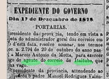
R. Koester writes in Carimbologia XXIII that there had been a post office there since 1882. However, this was a reopening, as there was a postal agency in Itaituba already mentioned in the regional press in December 1878:
O Liberal do Pará, 24/12/1878
As the post office is not mentioned in the imperial postal guide (Guia Postal do Imperio, 1880), it must have been closed by 1879 at the latest.
The oldest postmark to date is IPA-0140a (fig. Koester, op. cit.):
IPA-0140a (RK) 1890Carta da Republica dos Estados Unidos do Brazil, 1892
Um 1810 entstand am linken Ufer des Tapajós im Bereich der Siedlung Pinhel, 900 km südwestlich der späteren Provinzhauptstadt Belém do Pará, ein Hafen. 1853 wurde die dort entstandene Siedlung der Freguesia de Boim zugeschlagen, die zur Vila de Santarém gehörte. Im Dezember 1856 erfolgte die Erhebung zur Vila de Sant’Anna de Itaituba, die im März 1900 zur Stadt erklärt wurde. Im Dezember 1930 erfolgte die Herabstufung zum Distrikt, der direkt dem Bundesstaat Pará zugeordnet wurde. Seit Oktober 1935 gibt es wieder das Município de Itaituba. Das Wort stammt aus der Tupi-Sprache und bedeutet steinreiche Flüsse.
R. Koester schreibt in Carimbologia XXIII, dass es dort seit 1882 ein Postamt gab. Es handelt sich jedoch um eine Wiedereröffnung, da bereits im Dezember 1878 in der regionalen Presse von einer Postagentur in Itaituba die Rede war:
O Liberal do Pará, 24.12.1878
Da das Postamt im kaiserlichen Postführer (Guia Postal do Imperio, 1880) nicht erwähnt wird, muss es spätestens 1879 geschlossen worden sein.
Der bisher älteste Poststempel ist IPA-0140a (Abb. Koester, op. cit.):
Villiers de l’Ile Adam: Carta (…) da Provincia do Rio de Janeiro, 1850
Text update of January 8, 2025
Other names: Taipú
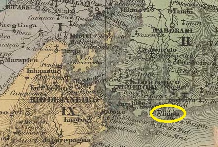
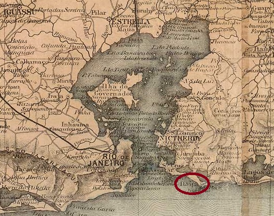
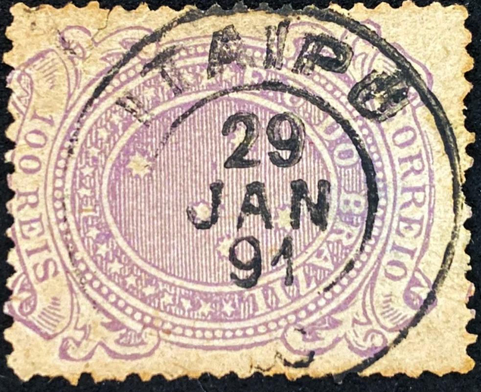
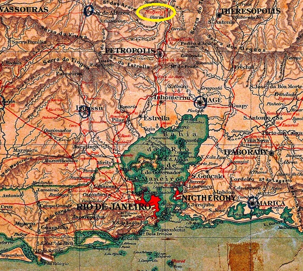
The Freguesia de S. Sebastião do Itaipú had existed since January 1755. It belonged to the Vila de Niterói and was located near the beach, 35 kilometres east of the capital Rio de Janeiro. In September 1890 it became a distrito of the Município de S. Gonçalo, but returned to the municipality of Niterói as a distrito in December 1943. The beautiful name Itaipu comes from the Tupi-guarani and means singing stone.
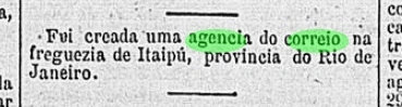
According to the regional press, there had been a post office there since August 1889:
Gazeta de Noticias, 29/08/1889
The only postmark from the imperial era to date, IRJ-1065a, had been presented by R. Koester in Carimbologia XXIII and bears the imperial seal:
IRJ-1065a (RK)
In the meantime, the double circle IRJ-1065b also appeared (Image: Felipe Piccinini):
IRJ-1065b (FP) 1891Colton & Colton: Provincia do Rio de Janeiro, 1866
Textaktualisierung am 8. Januar 2025
Andere Namen: Taipú
Die Freguesia de S. Sebastião do Itaipú bestand seit Januar 1755. Sie gehörte zur Vila de Niterói und lag in der Nähe des Strandes, 35 km östlich der Hauptstadt Rio de Janeiro. Im September 1890 wurde sie ein Distrito des Município de S. Gonçalo, kehrte aber im Dezember 1943 als Distrito zur Gemeinde Niterói zurück. Der schöne Name Itaipu kommt aus dem Tupi-guarani und bedeutet singender Stein.
Wie aus der regionalen Presse hervorgeht, gab es dort seit August 1889 ein Postamt:
Gazeta de Noticias, 29/08/1889
Der bisher einzige Poststempel aus der Kaiserzeit IRJ-1065a wurde von R. Koester in Carimbologia XXIII vorgestellt und trägt das kaiserliche Siegel:
IRJ-1065a (RK)
In der Zwischenzeit erschien auch der Doppelkreis IRJ-1065b (Bild: Felipe Piccinini):
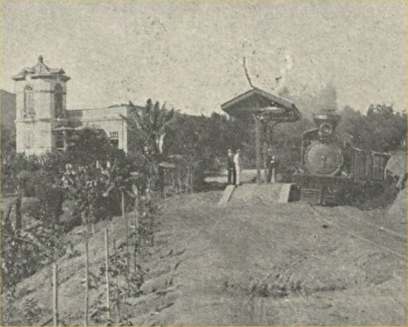
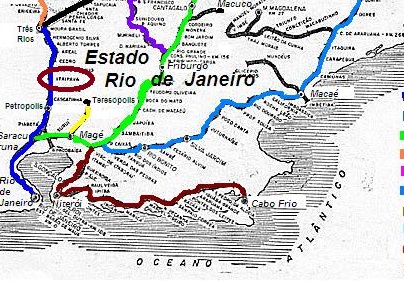
Itaipava station was opened in February 1886 by the railway company E.F. do Norte (formerly Príncipe do Grão-Pará) in the Município de Petrópolis, over 80 km north of the capital Rio de Janeiro. The line was taken over by the R.J. Northern Railway in 1888 and belonged to E.F. Leopoldina from around 1890 until it was closed in 1964. Today the tracks have disappeared and a shopping centre has been built on the former station site.
In May 1917 (Fon-Fon magazine, apud estacoesferroviarias.com.br)In July 2020 (photo Zezinho Suhett, on Google Maps)
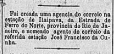
The regional press reports that there has been a post office at the station since October 1889
Diario do Commercio, 07/10/1889
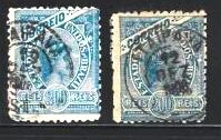
The oldest postmark to date is IRJ-1060a (Fig. agenciaspostais.com.br):
IRJ-1060a (PN) 1900-1906Estrada de Ferro Leopoldina
Der Bahnhof Itaipava wurde im Februar 1886 von der Eisenbahngesellschaft E.F. do Norte (ehemals Príncipe do Grão-Pará) eröffnet und lag im Município de Petrópolis, über 80 km nördlich der Hauptstadt Rio de Janeiro. Die Strecke wurde 1888 von der R.J. Northern Railway übernommen und gehörte von ca. 1890 bis zu ihrer Stilllegung 1964 der E.F. Leopoldina. Heute sind die Gleise verschwunden, auf dem ehemaligen Bahnhofsgelände befindet sich ein Einkaufszentrum.
Im Mai 1917 (Zeitschrift Fon-Fon, apud estacoesferroviarias.com.br)Im Juli 2020 (Foto Zezinho Suhett, auf Google Maps)
Die regionale Presse berichtet, dass es seit Oktober 1889 ein Postamt am Bahnhof gab:
Diario do Commercio, 07.10.1889
Der bisher älteste Poststempel ist IRJ-1060a (Abb. agenciaspostais.com.br):
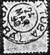
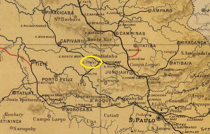
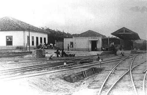
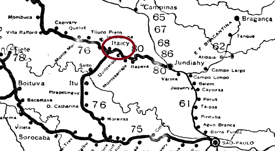
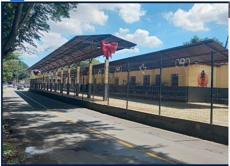
Itaicy station was opened in 1873 by the E.F. Ytuana railway company (Campinas branch line) and is located on the north bank of the Jundiaí in the Município Indaiatuba, 100 km north-west of the provincial capital of São Paulo. In the Tupi-Guarani language, Itaici means spring by the water. The railway line went to the Cia. União Sorocabana e Ytuana in 1892, to the Sorocabana Railway in 1907, to the E.F. Sorocabana in 1919 and belonged to FEPASA (estacoesferroviarias.com.br) from 1971 until it was shut down around 1988. Today, the tracks have disappeared and the station building has served as a cultural centre for the municipality of Indaiatuba since 2022.
Around 1940 (photo NN, on estacoesferroviarias.com.br)In March 2023 (photo Bruno Liberatori, on Google Maps)
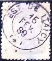
As reported in the regional press; there had been a post office at the station since December 1879
Correio Paulistano, 27/12/1879
The imperial postmark is the French type ISP-1965a (coll. Fuad Ferreira Fo.), which also appears in blue:
ISP-1965a (FF) 1884-1891Cia. Sorocabana e Ytuana, 1898
Der Bahnhof Itaicy wurde 1873 von der Eisenbahngesellschaft E.F. Ytuana (Zweigbahn Campinas) eröffnet und liegt am Nordufer des Jundiaí im Município Indaiatuba, 100 km nordwestlich der Provinzhauptstadt São Paulo. In der Tupi-Guarani-Sprache bedeutet Itaici Quelle am Wasser. Die Bahnlinie ging 1892 an die Cia. União Sorocabana e Ytuana, 1907 an die Sorocabana Railway, 1919 an die E.F. Sorocabana und gehörte von 1971 bis zur Stilllegung um 1988 der FEPASA (estacoesferroviarias.com.br). heute sind die Gleise verschwunden, das Bahnhofsgebäude dient seit 2022 als Kulturzentrum der Gemeinde Indaiatuba.
Um 1940 (Foto NN, auf estacoesferroviarias.com.br)Im März 2023 (Foto Bruno Liberatori, auf Google Maps)
Wie in der regionalen Presse berichtet; seit Dezember 1879 gab es ein Postamt am Bahnhof:
Correio Paulistano, 27.12.1879
Der kaiserliche Poststempel ist der französische Typ ISP-1965a (Samml. Fuad Ferreira Fo.), der auch in blau vorkommt:
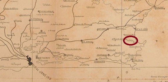
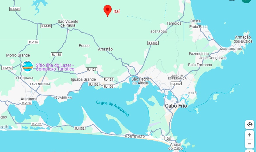
Here we have another village that has now disappeared from the map. Itahy (River of Stones, in Tupi-Guarani) was probably a settlement that emerged from a fazenda near the Freguesia de S. Pedro da Aldeia around Vila de Cabo Frio, 140 kilometres east of the capital Rio de Janeiro. Three changes of administration followed: in September 1890 to the newly founded Vila de Sapyatiba, in September 1892 back to the Vila de Cabo Frio and six months later to the Vila de S. Pedro da Aldeia.
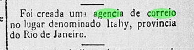
As the press in Rio reported, there had been a post office there since November 1884:
Diario do Brazil, 29/11/1884
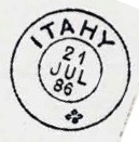
According to P. Novaes (agenciaspostais.com.br), the post office was closed in July 1931. The imperial postmark here is IRJ-1055a, which also exists in dark violet and is illustrated in P. Ayres’ Catálogo de Carimbos Brasil-Império (S. Paulo, 1937, 1942) on p. 121:
IRJ-1055a (P.A. p. 121) 1885-1887
R. Koester also showed the postmark with the imperial seal IRJ-1055b in Carimbologia XXIII:
IRJ-1055b (RK)Google Maps
Andere Namen: Itahim, Itaí
Hier haben wir eine weitere Ortschaft, die heute von der Landkarte verschwunden ist. Itahy (Fluss der Steine, in Tupi-Guarani) war vermutlich eine Siedlung, die aus einer Fazenda in der Nähe der Freguesia de S. Pedro da Aldeia im Gebiet der Vila de Cabo Frio, 140 km östlich der Hauptstadt Rio de Janeiro, hervorging. Es folgten drei Verwaltungswechsel: im September 1890 zur neu gegründeten Vila de Sapyatiba, im September 1892 zurück zur Vila de Cabo Frio und ein halbes Jahr später zur Vila de S. Pedro da Aldeia.
Wie die Presse in Rio berichtete, gab es dort seit November 1884 ein Postamt:
Diario do Brazil, 29.11.1884
Nach P. Novaes (agenciaspostais.com.br) wurde das Postamt im Juli 1931 geschlossen. Der kaiserliche Poststempel hier ist IRJ-1055a, den es auch in dunkelviolett gibt und der in P. Ayres‘ Catálogo de Carimbos Brasil-Império (S. Paulo, 1937, 1942) auf S. 121 abgebildet ist:
IRJ-1055a (P.A. S. 121) 1885-1887
R. Koester zeigte in Carimbologia XXIII auch den Poststempel mit dem kaiserlichen Siegel IRJ-1055b:
Villiers de l’Ile Adam: Carta (…) da Provincia do Rio de Janeiro, 1850
See also Tacoahy (TRJ-1600)
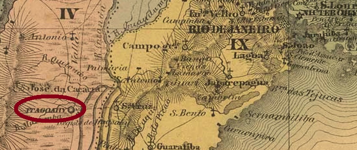
The parish of São Francisco Xavier de Tagoahy (or Tacoahy) was established in December 1795 by royal decree (Ordem Régia) 70 km west of the colonial capital Rio de Janeiro. The word Taguahy comes from the Tupi-Guarani language, means something like waters with yellow mud and names the river in the area that flows into the Sepetiba Bay. In 1818, the place was declared a vila for five months before being reclassified as a district in November of that year. In 1819 it became a vila again, and since June 1892 Itaguaí (as it is now spelled) has been a town in its own municipal charter.
Nova Monteiro (Administrações e Agencias Postaes do Brasil Imperio, in Brasil Filatelico/RJ, 1934-5; Reprint SPP 1994-1999) and Reinhold Koester (Carimbologia XXIII) agree that there was a post office there from May 1829. The first local postmark is also the only one with Tagoahy so far. TRJ-1600a has already been presentsed by Cicero A. Almeida under No. 380 in Carimbos Postais – século XIX (Rio de Janeiro, 1989):
TRJ-1600a (MPT 380) 1829ff
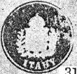
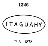
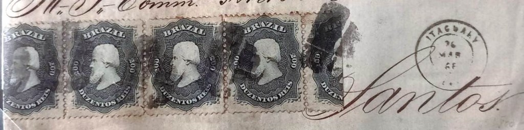
This was followed by local cancellations with the spelling Itaguahy, beginning with IRJ-0675a, which also exists in red and dark violet and which received the no. 1326 in P. Ayres Catálogo de Carimbos Brasil-Império (S. Paulo, 1937, 1942):
IRJ-0675a (P.A. 1326) 1866ff-1882ff
Then came the very rare French type IRJ-0675b (collect. Fuad Ferreira Fo.):
IRJ-0675b (FF) 1868
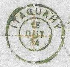
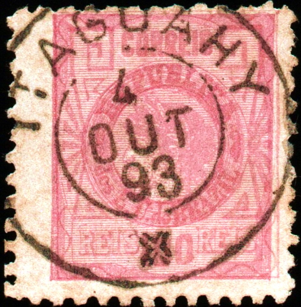
Its successor IRJ-0675c (fig. agenciaspostais.com.br), on the other hand, is more common:
IRJ-0675c (PN) 1877-1888
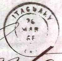
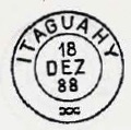
The following cancels were also used in the Republic, starting with IRJ-0675d, which is also included in P. Ayres (op. cit.):
A mute cancellation from Itaguahy was registered by James Dingler and Klerman W. Lopes as no. 3567 in Mute Cancellations of the Brazil Empire / Carimbos Mudos do Brasil Império (Brazil Philatelic Association, Rio de Janeiro, 2000):
BPA 3567 (1866ff-1877ff)
We can present three more cancellations of this type:
1866ff (image from the Internet)1868 (Fuad Ferreira Fo. collection)1878 (FM collection)Almanak Laemmert, 1866
Siehe auch Tacoahy (TRJ-1600)
Die Pfarrei São Francisco Xavier de Tagoahy (oder Tacoahy) wurde im Dezember 1795 durch königliche Verfügung (Ordem Régia) 70 km westlich der Kolonialhauptstadt Rio de Janeiro errichtet. Das Wort Taguahy kommt aus der Tupi-Guarani-Sprache, bedeutet etwa Gewässer mit gelbem Schlamm und benennt auch den Fluss der Gegend, der in die Bucht von Sepetiba mündet. 1818 wurde der Ort fünf Monate lang als Vila erklärt, bevor im November des Jahres die Rückstufung als Distrikt erfolgte. 1819 wurde daraus wieder eine Vila, und seit Juni 1892 ist Itaguaí (wie es heute geschrieben wird) eine Stadt im eigenen Gemeindesitz.
Nova Monteiro (Administrações e Agencias Postaes do Brasil Imperio, in Brasil Filatelico/RJ, 1934-5; Reprint SPP 1994-1999) und Reinhold Koester (Carimbologia XXIII) sind sich darüber einig, dass es dort seit Mai 1829 ein Postamt gab. Der erste lokale Poststempel ist auch bisher der einzige mit der Ortsbezeichnung Tagoahy. TRJ-1600a wurde bereits durch Cicero A. Almeida unter Nr. 380 in Carimbos Postais – século XIX (Rio de Janeiro, 1989) vorgestellt:
TRJ-1600a (MPT 380) 1829ff
Es folgten Ortsstempel mit der Schreibweise Itaguahy, beginnend mit IRJ-0675a, den es auch in rot und dunkelviolett gibt und der in P. Ayres Catálogo de Carimbos Brasil-Império (S. Paulo, 1937, 1942) die Nr. 1326 erhielt:
IRJ-0675a (P.A. 1326) 1866ff-1882ff
Dann kam der sehr seltene französische Typ IRJ-0675b (Samml. Fuad Ferreira Fo.):
IRJ-0675b (FF) 1868
Sein Nachfolger IRJ-0675c (Abb. agenciaspostais.com.br) ist dagegen häufiger anzutreffen:
IRJ-0675c (PN) 1877-1888
Die folgenden Stempel wurden auch in der Republik verwendet, beginnend mit IRJ-0675d, der auch in P. Ayres (op. cit.) enthalten ist:
Ein stummer Stempel aus Itaguahy wurde von James Dingler und Klerman W. Lopes als Nr. 3567 in Mute Cancellations of the Brazil Empire / Carimbos Mudos do Brasil Império (Brazil Philatelic Association, Rio de Janeiro, 2000) registriert:
BPA 3567 (1866ff-1877ff)
Wir können noch drei weitere Stempel dieser Art vorstellen:
1866ff (Abb. aus dem Internet)1868 (Samml. Fuad Ferreira Fo.)1878 (Samml. FM)