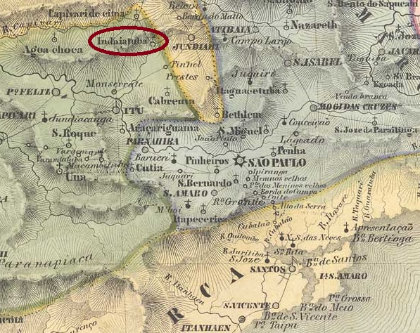
Villiers de l’Ile Adam: Carta (…) da Provincia de São Paulo, 1847
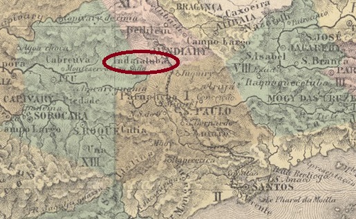
The Freguesia de N. Sra da Candelária de Indaiatuba (also spelt Indayatuba) was founded in December 1830, belonged to the Vila de Itu and was located on the east bank of the Córrego Barnabé, 100 km north-west of the provincial capital of São Paulo. It became a vila in March 1859 and a town in December 1906. The Indian name Indaiatuba means many palm trees.
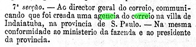
Nova Monteiro writes in Administrações e Agencias Postaes do Brasil Imperio (Brasil Filatelico/RJ, 1934-5; reprint SPP 1994-1999) that there had been a post office there since July 1860. This is confirmed by the bulletin of the imperial ministry:
Boletim do Ministerio do Imperio, July 1860
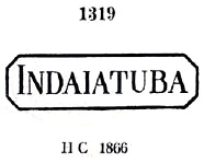
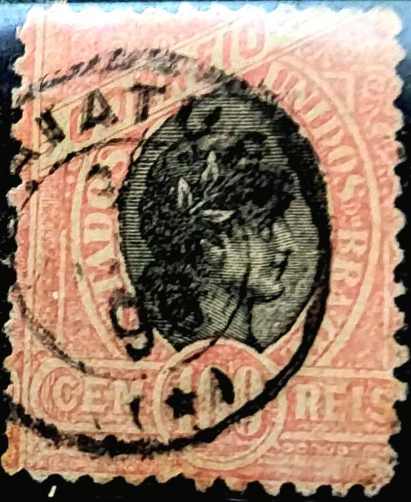
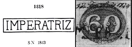
The first postmark is ISP-0590a, which was given the number 1319 by P. Ayres in the Catálogo de Carimbos Brasil-Império (S. Paulo, 1937, 1942):
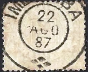
ISP-0590a (P.A. 1319) 1860ff-1869
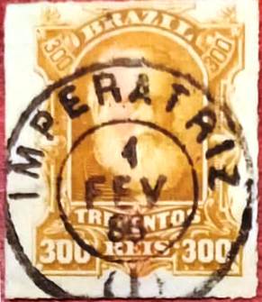
Then came the double circle ISP-0590b (fig. R. Koester, in Carimbologia XXII):
ISP-0590b (RK) 1885-1886
Towards the end of the century, the French type ISP-0590c also arrived (ill. from the Internet):
ISP-0590c (Grupo Império/WhatsApp) 1890-1895
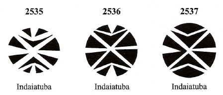
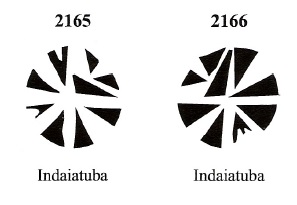
James Dingler and Klerman W. Lopes have listed at least 5 mute cancels from Indaiatuba in Mute Cancellations of the Brazil Empire / Carimbos Mudos do Brasil Império (Brazil Philatelic Association, Rio de Janeiro, 2000):
BPA 2050 or 2535 (P.A. 542, 1866ff) – 2536 – 2537BPA 2165 – 2166Atlas do Imperio do Brasil, 1868
Die Freguesia de N. Sra da Candelária de Indaiatuba (auch Indayatuba geschrieben) wurde im Dezember 1830 gegründet, gehörte zur Vila de Itu und lag am Ostufer des Córrego Barnabé, 100 km nordwestlich der Provinzhauptstadt São Paulo. Es wurde im März 1859 zur Vila und im Dezember 1906 zur Stadt erhoben. Der indianische Name Indaiatuba bedeutet viele Palmen.
Nova Monteiro schreibt in Administrações e Agencias Postaes do Brasil Imperio (Brasil Filatelico/RJ, 1934-5; Nachdruck SPP 1994-1999), dass es dort seit Juli 1860 ein Postamt gab. Dies wird durch das Bulletin des kaiserlichen Ministeriums bestätigt:
Boletim do Ministerio do Imperio, Juli 1860
Der erste Poststempel ist ISP-0590a, der von P. Ayres die Nummer 1319 im Catálogo de Carimbos Brasil-Império (S. Paulo, 1937, 1942) erhielt:
ISP-0590a (P.A. 1319) 1860ff-1869
Danach kam der Doppelkreis ISP-0590b (Abb. R. Koester, in Carimbologia XXII):
ISP-0590b (RK) 1885-1886
Gegen Ende des Jahrhunderts kam auch der französische Typ ISP-0590c (Abb. aus dem Internet):
ISP-0590c (Grupo Império/WhatsApp) 1890-1895
James Dingler und Klerman W. Lopes haben mindestens 5 stumme Stempel aus Indaiatuba in Mute Cancellations of the Brazil Empire / Carimbos Mudos do Brasil Império (Brazil Philatelic Association, Rio de Janeiro, 2000) aufgeführt:
Villiers de l’Ile Adam: Carta (…) das Provincias do Rio Grande do Norte e Parahiba, 1848
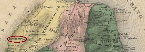
Other names: Serra do Martins, Maioridade, Martins (1890)
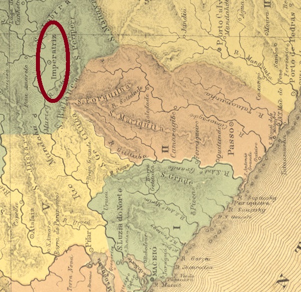
This another Imperatriz in north-east Brazil also went through several place names for political reasons. From November 1840 it was the Freguesia de N. Sra. da Conceição da Serra do Martins, which belonged to the Vila de Portalegre and was located on the mountain range of the same name 380 kilometres west of the provincial capital Natal. In November 1841, it became Vila da Maioridade to celebrate the (premature) coming of age of Emperor D. Pedro II, who was not yet 16 years old at the time. In October 1847, it was elevated to the status of a town: Cidade de Imperatriz. Since the beginning of the Republic, in February 1890, the old name Município de Martins has been used again.
According to R. Koester (Carimbologia XXII), there is also said to have been a post office here since April 1818, even before Brazil’s independence. This information has not yet been confirmed; it is more likely that it was opened later. There are also no known imperial postmarks from this location.
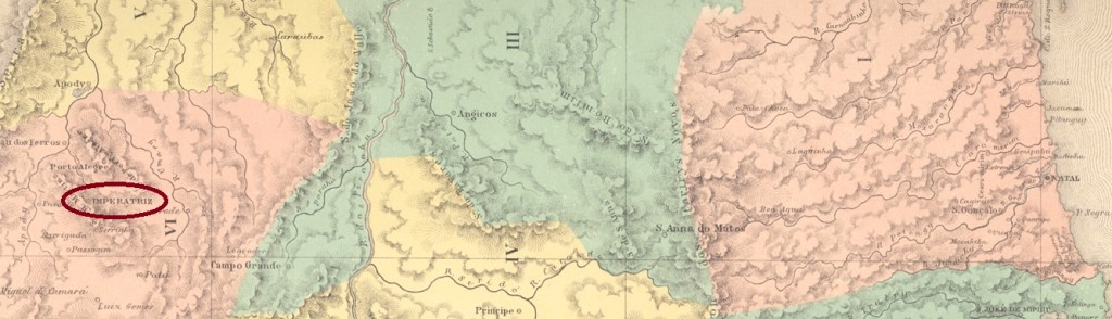
Atlas do Imperio do Brasil, 1868
Andere Namen: Serra do Martins, Maioridade, Martins (1890)
Auch diese Imperatriz im Nordosten Brasiliens hat aus politischen Gründen mehrere Ortsnamen durchlaufen. Seit November 1840 war sie die Freguesia de N. Sra. da Conceição da Serra do Martins, die zur Vila de Portalegre gehörte und am gleichnamigen Gebirge 380 km westlich der Provinzhauptstadt Natal lag. Im November 1841 wurde sie zur Vila da Maioridade, um die (verfrühte) Volljährigkeit des Kaisers D. Pedro II. zu feiern, der zu diesem Zeitpunkt noch keine 16 Jahre alt war. Im Oktober 1847 wurde sie zur Stadt erhoben: als Cidade de Imperatriz. Seit Beginn der Republik, im Februar 1890, ist der alte Name Município de Martins wieder gültig.
Nach R. Koester (Carimbologia XXII) soll es auch hier seit April 1818, also noch vor der Unabhängigkeit Brasiliens, ein Postamt gegeben haben. Diese Angabe konnte bisher nicht bestätigt werden, wahrscheinlicher ist eine spätere Inbetriebnahme. Auch sind bisher keine kaiserlichen Poststempel aus diesem Ort bekannt.
Carta da Republica dos Estados Unidos do Brazil, 1892
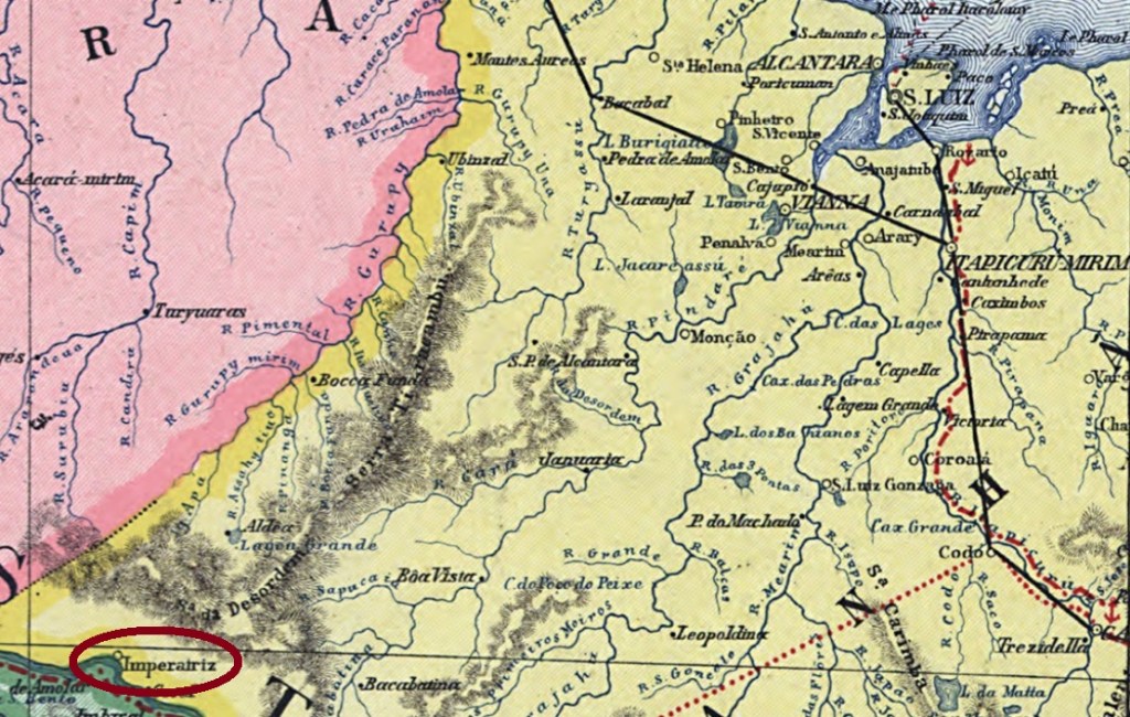
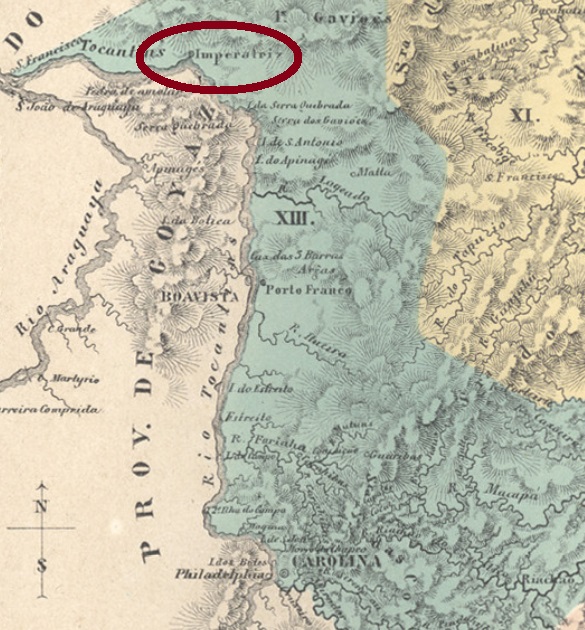
Other names : Santa Thereza do Tocantins, Villa Nova da Imperatriz
See also Santa Thereza da Imperatriz (SMA-0258)
The history of this locality with such a distinguished name began in October 1840 as a colony and prision in the municipality of Carolina. It was situated on the east bank of the Tocantins River, over 600 km southwest of the province capital São Luís. In August 1856 it ascended to the municipality of Villa Nova de Santa Thereza da Imperatriz. Since April 1924 it has the simplified name of Imperatriz.
According to Reinhold Koester (Carimbologia XXII), the local post office was created in May 1865. Until now no imperail cancel could be surely assigned to this place.
Atlas do Imperio do Brasil, 1868
Andere Namen : Santa Thereza do Tocantins, Villa Nova da Imperatriz
Siehe auch Santa Thereza da Imperatriz (SMA-0258)
Die Geschichte dieser Ortschaft mit solcher vornehmen Bezeichnung begann im Oktober 1840: es war eine Gefängniskolonie im Município von Carolina und lag am Ostufer des Flusses Tocantins, über 600 km südwestlich der Provinzhauptstadt São Luís entfernt. Im August 1856 wurde daraus der Município von Villa Nova de Santa Thereza da Imperatriz, und seit April 1924 gilt der vereinfachte Ortsname Imperatriz.
Reinhold Koester schreibt den Mai 1865 als Entstehungsdatum fürs örtliche Postamt. Bislang konnte diesem Ort kein kaiserlicher Poststempel sicher zugeordnet werden.
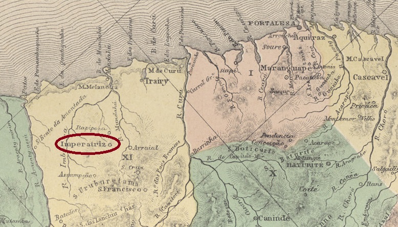
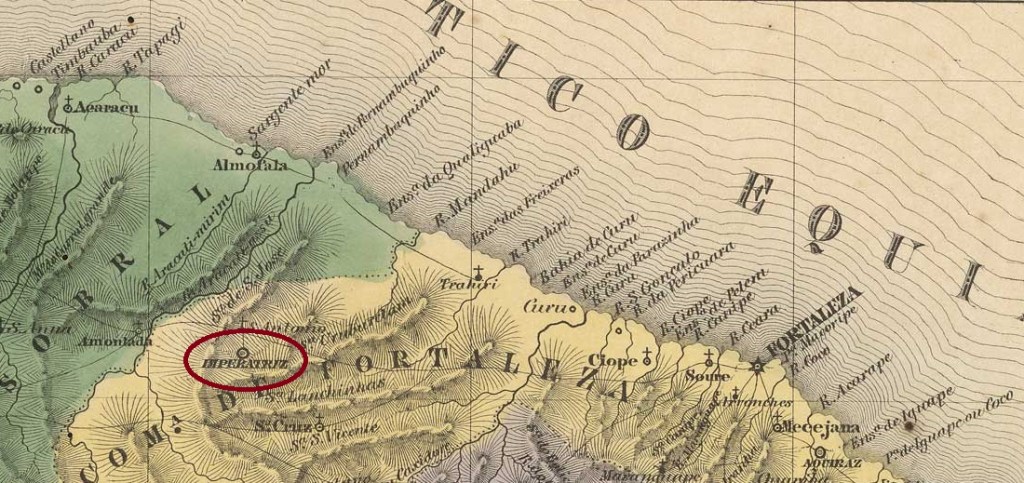
Other names: Arraial de São José, Vila Velha, Itapipoca
From April 1744, this place was the Arraial de São José, which belonged to the Vila de Fortaleza, although it was 150 kilometres to the west. In February 1823, it was renamed Vila da Imperatriz for the first time in honour of the new empress. Two weeks after the proclamation of the republic, in December 1889, the empress was forgotten, and the Vila was henceforth called Itapipoca. The Indian word means bursting stone. Itapipoca has been a city since August 1915.
As R. Koester writes in Carimbologia XXII, there had been a post office there since July 1846.
So far, no imperial postmark could be assigned to this place with certainty.
Villiers de l’Ile Adam: Carta (…) da Provincia do Ceara, 1849
Andere Namen: Arraial de São José, Vila Velha, Itapipoca
Seit April 1744 war dieser Ort der Arraial de São José, der zur Vila de Fortaleza gehörte, obwohl er 150 km westlich lag. Im Februar 1823 erfolgte die erste Umbenennung in Vila da Imperatriz zu Ehren der neuen Kaiserin. Zwei Wochen nach der Ausrufung der Republik, im Dezember 1889, war die Kaiserin vergessen und die Vila hieß fortan Itapipoca. Das indianische Wort bedeutet zerplatzender Stein. Seit August 1915 ist Itapipoca eine Stadt.
Wie R. Koester in Carimbologia XXII schreibt, gab es dort seit Juli 1846 ein Postamt.
Bisher konnte kein kaiserlicher Poststempel mit Sicherheit diesem Ort zugeordnet werden.
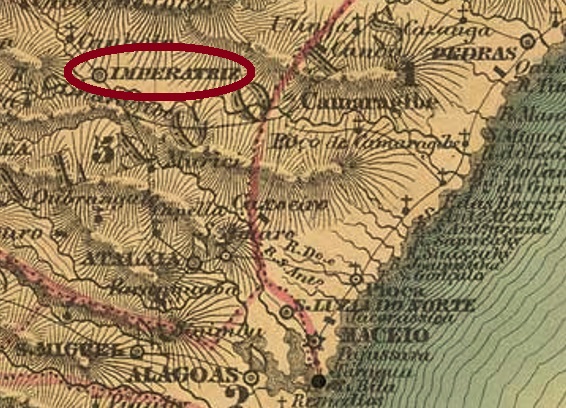
Villiers de l’Ile Adam: Carta (…) das Provincias de Pernambuco, Alagoas e Sergipe, 1848
Other names: Santa Maria Magdalena, União, União dos Palmares
See also Villa Nova da Imperatriz (VAL-0075)
The former freguesia of Santa Maria Magdalena was located near the vila of Atalaia on the east bank of the river Mundaú, 75 km northwest of the later provincial capital Maceió. In October 1831, the place became Villa Nova da Imperatriz. In July 1876, it was downgraded to the district of Atalaia, but regained villa status nine years later and became a town in August 1889. After the military coup that introduced the Republic, the empress was not even tolerated as a place name, and the town was renamed União (Unity) in September 1890. Since December 1943, it has been the Municipio of União dos Palmares, in memory of the quilombo (refuge for escaped slaves) that existed there from 1580 to 1694.
Three periods of operation for the local post office were found. A first opening is said to have taken place around 1835, as Aldo Cardoso writes in Contribuição para a História dos Correios de Alagoas (Maceió, 1969). The second period began in 1845, as both Cardoso and the Directory of Imperial Post Offices (Tabella das Agencias do Correio do Imperio, Rio de Janeiro, 1885) record, and ended in October 1847, according to the Official Press in Rio:
Gazeta Official/RJ, 13/10/1847
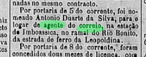
The agency was created for the third time in November 1859, according to a report by the Imperial Ministry:
Boletim do Ministerio do Imperio, 14/11/1859
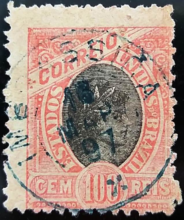
The oldest postmark here so far is IAL-0075a, which was given the no. 1.318 by P. Ayres in the Catálogo de Carimbos Brasil-Império (S. Paulo, 1937, 1942). R. Koester wrote in Carimbologia that this stamp belonged to Imperatriz in Rio Grande do Norte (IRN-0090) or Ceará (ICE-0165). However, Henrique B. Ferreira in Catálogo ilustrado dos carimbos sobre os olhos-de-boi (4a. ed., Porto Alegre, 2017) pictured the cancel under a date of 1845, which was only possible in Alagoas at the time.
IAL-0075a (P.A. 1318, HBF) 1845ff
The next postmark is still to be confirmed. It bears below a (I), and since the Imperatriz post office in Alagoas is both alphabetically and chronologically the first of the four places of the same name in north-east Brazil, IAL-0075b (coll. Fuad Ferreira Fo.) is provisionally listed here:
IAL-0075b (FF) 1885-1886Atlas do Imperio do Brasil, 1868
Andere Namen: Santa Maria Magdalena, União, União dos Palmares
Siehe auch Villa Nova da Imperatriz (VAL-0075)
Die ehemalige Freguesia von Santa Maria Magdalena lag bei der Vila von Atalaia am Ostufer des Flusses Mundaú, 75 km nordwestlich der Provinzhauptstadt Maceió. Im Oktober 1831 wurde der Ort zur Villa Nova da Imperatriz. Im Juli 1876 wurde die Villa zum Distrikt von Atalaia herabgestuft, erlangte aber neun Jahre später den Villa-Status wieder und wurde im August 1889 eine Stadt. Nach dem Militärputsch, der die Republik einführte, wurde die Kaiserin nicht mal als Ortsbezeichnung toleriert, und die Stadt wurde im September 1890 zu União (Eintracht) umbenannt. Seit Dezember 1943 ist es der Municipio von União dos Palmares, in Erinnerung an den Quilombo (Zufluchtstätte für geflohene Sklaven), der dort von 1580 bis 1694 existierte.
Drei Betriebsperioden fürs örtliche Postamt wurden gefunden. Eine erste Eröffnung soll ca. 1835 stattgefunden haben, wie Aldo Cardoso in Contribuição para a História dos Correios de Alagoas (Maceió, 1969) schreibt. Die zweite Periode fing 1845 an, wie sowohl Cardoso als auch das Verzeichnis der kaiserlichen Postämter (Tabella das Agencias do Correio do Imperio, Rio de Janeiro, 1885) registrieren, und endete im Oktober 1847, wie aus der Amtspresse in Rio hervorgeht:
Gazeta Official/RJ, 13.10.1847
Die Agentur wurde im November 1859 zum dritten Mal ins Leben gerufen, laut Bericht des Imperialministeriums:
Boletim do Ministerio do Imperio, 14.11.1859
Der bisher älteste Stempel hier ist IAL-0075a, der von P. Ayres die Nr. 1.318 im Catálogo de Carimbos Brasil-Império (S. Paulo, 1937, 1942) erhielt. R. Koester schrieb in Carimbologia, dass dieser Stempel zu Imperatriz in Rio Grande do Norte (IRN-0090) oder Ceará (ICE-0165) gehörte. Allerdings hat Henrique B. Ferreira in Catálogo ilustrado dos carimbos sobre os olhos-de-boi (4a. ed., Porto Alegre, 2017) den Stempel mit einer Datierung von 1845 abgebildet, was damals nur in Alagoas möglich war.
IAL-0075a (P.A. 1318, HBF) 1845ff
Der nächste Poststempel ist noch zu bestätigen. Er trägt unten eine (I), und da das Postamt Imperatriz in Alagoas sowohl alphabetisch als auch chronologisch an erster Stelle der vier gleichnamigen Orte im Nordosten Brasiliens steht, wird hier vorläufig IAL-0075b (Samml. Fuad Ferreira Fo.) aufgeführt:
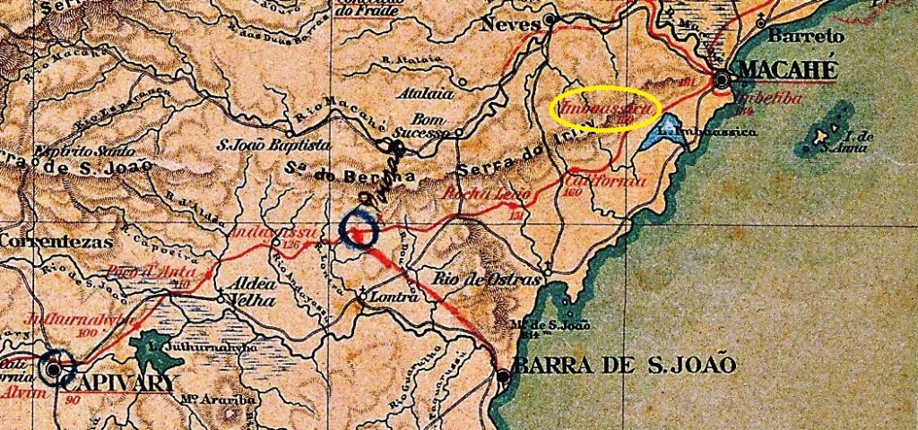
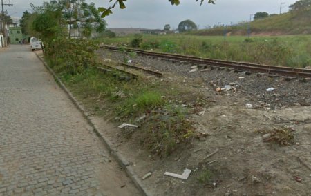
Imboassica station was opened in November 1888 by the railway company E.F. Leopoldina (Ramal de Rio Bonito) and was located on the northern shore of Lake Imboassica in the Município Barra de S. João, 180 km north-east of the capital Rio de Janeiro. The area around the railway station belonged to the Município de Indaiassú from December 1901, to the Município de Casimiro de Abreu from March 1938 and to the district of Rio das Ostras from March 1970, which has been an independent Município since April 1992. The line belonged to Rede Ferroviária Federal S.A. from 1975 until its closure in 1996, as R. Giesbrecht writes on estacoesferroviarias.com.br. The tracks are still there today, but the station building was demolished around 2013.
In July 2014 (Photo: Sydney Correia, on estacoesferroviarias.com.br)
According to R. Koester (Carimbologia XXII), there had been a post office at the station since January 1889, which is confirmed by the press in Rio:
Cidade do Rio, 09.01.1889
The oldest postmark to date is IRJ-0625a (illus. Luiz C. Fritzen):
IRJ-0625a (LCF) 1897
Koester (op. cit.) also shows a postmark with the imperial seal IRJ-0625b:
IRJ-0625b (RK)Estrada de Ferro Leopoldina
Der Bahnhof Imboassica wurde im November 1888 von der Eisenbahngesellschaft E.F. Leopoldina (Ramal de Rio Bonito) eröffnet und lag am Nordufer des Imboassica-Sees im Município Barra de S. João, 180 km nordöstlich der Hauptstadt Rio de Janeiro. Das Gebiet um den Bahnhof gehörte ab Dezember 1901 zum Município de Indaiassú, ab März 1938 zum Município de Casimiro de Abreu, ab März 1970 zum Distrikt Rio das Ostras, der seit April 1992 ein eigenständiges Município ist. Die Strecke gehörte von 1975 bis zur Stilllegung 1996 der Rede Ferroviária Federal S.A., wie R. Giesbrecht auf estacoesferroviarias.com.br schreibt. Heute sind die Gleise noch vorhanden, das Bahnhofsgebäude wurde um 2013 abgerissen.
Im Juli 2014 (Foto: Sydney Correia, auf estacoesferroviarias.com.br)
Laut R. Koester (Carimbologia XXII) gab es seit Januar 1889 ein Postamt am Bahnhof, was von der Presse in Rio bestätigt wird:
Cidade do Rio, 09.01.1889
Der bisher älteste Poststempel ist IRJ-0625a (Abb. Luiz C. Fritzen):
IRJ-0625a (LCF) 1897
Koester (op. cit.) zeigt auch einen Stempel mit dem kaiserlichen Siegel IRJ-0625b:
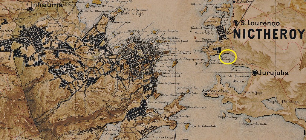
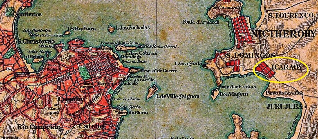
The chapel of Sant’Anna de Icarahy was idyllically situated on the beach in a suburb of Vila de Niterói, 20 kilometres east of the imperial capital of Rio de Janeiro. Icaraí (as it is now spelt) became a separate distrito in May 1892, but lost this status in March 1938 and has been a district of the city of Niterói ever since.
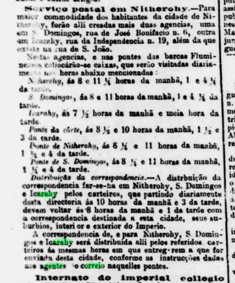
R. Koester writes in Carimbologia XXII that there has been a post office there since 1881, P. Novaes (agenciaspostais.com.br) states ‘ca. 1875’. In the meantime, an earlier date for the founding of the local postal agency has been found in the regional press:
Jornal do Commercio, 16/04/1872
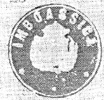
The only imperial postmark to date is IRJ-0595a (Fig. Felipe Piccinini):
IRJ-0595a (FP) 1877ff-1880Almanak LAemmert, 1892
Die Kapelle Sant’Anna de Icarahy lag idyllisch am Strand in einem Vorort der Vila de Niterói, 20 km östlich der kaiserlichen Hauptstadt Rio de Janeiro. Icaraí (wie es heute geschrieben wird) wurde im Mai 1892 ein eigener Distrito, verlor diesen Status aber im März 1938 und ist seitdem ein Stadtteil der Großstadt Niterói.
R. Koester schreibt in Carimbologia XXII, dass es dort seit 1881 ein Postamt gab, P. Novaes (agenciaspostais.com.br) gibt dafür „ca. 1875“ an. Inzwischen wurde in der regionalen Presse ein früheres Datum für die Gründung der örtlichen Postagentur gefunden:
Jornal do Commercio, 16.04.1872
Der bisher einzige kaiserliche Poststempel ist IRJ-0595a (Abb. Felipe Piccinini):
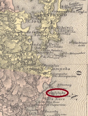
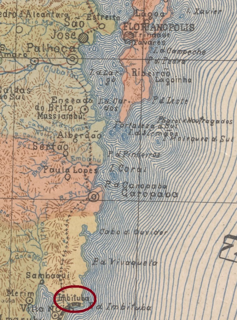
Other names: Villa Nova de Sant’Anna, Henrique Lage, Imbitiba
The indigenous word Imbituba means many Imbés. This plant (Philodendron imbe) was also sacred to the Indians because it embodied strength, resistance and protection.
Philodendron imbe (on maniadeplantas.com.br)
The history of the village of Imbituba is inextricably linked to the Freguesia of Villa Nova de Sant’Anna, which began in 1811, belonged to the Vila of Laguna and was located barely 100 km south of the later provincial capital Desterro (now Florianópolis). In January 1927, the place was designated a district called Imbituba. After that, the place name changed four times: back to Villa Nova (1930), then to Henrique Lage (1949), in honour of the founder (1881-1941) of the port there. But the name Imbituba returned twice: in 1938 and 1959.
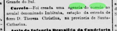
After the establishment of the post office in Vila Nova in May 1881, a post office was also set up in Imbituba in April 1882, as Luiz. C. Fritzen writes in Agências Postais da Província de Santa Catharina durante o Império Brasileiro (Boletim da AFSC no. 56, Florianópolis, 2007). This is confirmed by the press in Rio:
Jornal do Commercio/RJ, 25/04/1882
The oldest postmark to date is probably not the first. ISC-0120b (image from the Internet) was found with a date from 1906:
ISC-0120b (EB) 1906
After the opening of the E.F. Dona Teresa Christina railway station in September 1884, the local post office probably moved there.
Estado de Santa Catharina, 1907
Andere Namen: Villa Nova de Sant’Anna, Henrique Lage, Imbitiba
Das indigene Wort Imbituba bedeutet viele Imbés. Diese Pflanze (Philodendron imbe) war auch den Indanern heilig, denn sie verkörperte Kraft, Widerstand und Schutz.
Philodendron imbe (auf maniadeplantas.com.br)
Die Geschichte der Ortschaft Imbituba ist untrennbar mit der Freguesia von Villa Nova de Sant’Anna verbunden. Diese entstand 1811 bei der Vila von Laguna und lag knapp 100 km südlich der späteren Provinzhauptstadt Desterro (heute Florianópolis) entfernt. Im Januar 1927 wurde der Ort zu einem Distrikt namens Imbituba ernannt. Danach wechselte der Ortsname viermal: zurück zu Villa Nova (1930), dann zu Henrique Lage (1949), zu Ehren vom Gründer (1881-1941) des dortigen Hafens. Aber der Name Imbituba kehrte zweimal zurück: 1938 und 1959.
Nach der Entstehung des Postamts in Vila Nova im Mai 1881, wurde im April 1882 auch ein Postamt in Imbituba ins Leben gerufen, wie Luiz. C. Fritzen in Agências Postais da Província de Santa Catharina durante o Império Brasileiro (Boletim da AFSC no. 56, Florianópolis, 2007) schreibt. Dies wird von der Presse in Rio bestätigt:
Jornal do Commercio/RJ, 25.04.1882
Der bisher älteste Poststempel ist vermutlich nicht der erste. ISC-0120b (Abb. aus dem Internet) wurde mit einem Datum aus 1906 gefunden:
ISC-0120b (EB) 1906
Nach der Eröffnung des Bahnhofs der E.F. Dona Teresa Christina im September 1884 zog das örtliche Postamt vermutlich dorthin um.
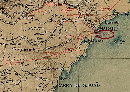
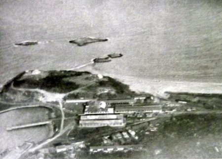
Imbetiba station was opened in June 1873 by the railway company E.F. Macaé e Campos, Imbetiba branch, and was located almost on the beach in the Município Macaé, 190 km north-east of the capital Rio de Janeiro. The railway line went to E.F. Leopoldina around 1890 and belonged to Rede Ferroviária Federal S.A. from 1975 until its closure in 1996 (estacoesferroviarias.com.br). Today, the tracks have disappeared, the entire harbour facility belongs to the oil giant Petrobras and it is not known what has become of the former railway station.
Around 1940 (Photo Ricardo Q. de Matos, on estacoesferroviarias.com.br)
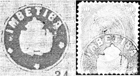
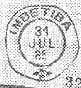
As Paulo Novaes writes on agenciaspostais.com, there had been a post office in the station since August 1875, which was closed for the first time in July 1897. The oldest postmark to date is IRJ-1775a (Image: Fuad Ferreira Fo.) 1882-1885
IRJ-1775a (FF) 1882-1885
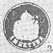
Two very similar postmarks followed: IRJ-1775b (Image: R. Koester, in Carimbologia XXII) and IRJ-1775c (Image: Felipe Piccinini):
IRJ-1775b (RK) 1884-1885IRJ-1775c (FP) 1885-1887
R. Koester showed in Carimbologia XXII two postmarks with the imperial seal, IRJ-1775d (Image: R. Koester – Felipe Piccinini) and IRJ-1775e (R. Koester):
IRJ-1775d (RK-FP) 1875ffIRJ-1775e (RK)
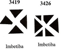
James Dingler and Klerman W. Lopes have listed two mute cancellations of Imbetiba in Mute Cancellations of the Brazil Empire / Carimbos Mudos do Brasil Império (Brazil Philatelic Association, Rio de Janeiro, 2000):
BPA 3419 (1883ff) – 3426 (P.A. 116, 1883ff)E. F. Leopoldina
Der Bahnhof Imbetiba wurde im Juni 1873 von der Eisenbahngesellschaft E.F. Macaé e Campos, Imbetiba- Zweig eröffnet und lag fast am Strand im Município Macaé, 190 km nordöstlich der Hauptstadt Rio de Janeiro. Die Bahnlinie ging um 1890 an die E.F. Leopoldina und gehörte von 1975 bis zu ihrer Stilllegung 1996 der Rede Ferroviária Federal S.A. (estacoesferroviarias.com.br). Heute sind die Gleise verschwunden, die gesamte Hafenanlage gehört dem Ölgiganten Petrobras und es ist nicht bekannt, was aus dem ehemaligen Bahnhof geworden ist.
Um 1940 (Foto Ricardo Q. de Matos, auf estacoesferroviarias.com.br)
Wie Paulo Novaes auf agenciaspostais.com schreibt, gab es im Bahnhof seit August 1875 ein Postamt, das im Juli 1897 zum ersten Mal geschlossen wurde. Der bislang älteste Poststempel ist IRJ-1775a (Abb. Fuad Ferreira Fo.):
IRJ-1775a (FF) 1882-1885
Es folgten zwei sehr ähnliche Stempel: IRJ-1775b (Abb. Koester in Carimbologia XXII) und IRJ-1775c (Abb. F. Piccinini):
IRJ-1775b (RK) 1884-1885IRJ-1775c (FP) 1885-1887
R. Koester zeigte in Carimbologia XXII zwei Poststempel mit dem kaiserlichen Siegel, IRJ-1775d (Abb. Koester – F. Piccinini) und IRJ-1775e (Abb. Koester):
IRJ-1775d (RK-FP) 1875ffIRJ-1775e (RK)
James Dingler und Klerman W. Lopes haben in Mute Cancellations of the Brazil Empire / Carimbos Mudos do Brasil Império (Brazil Philatelic Association, Rio de Janeiro, 2000) zwei stumme Abstempelungen von Imbetiba aufgeführt:
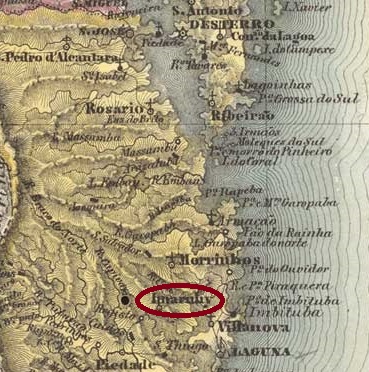
The Freguesia de S. João Baptista de Imaruí, which belonged to the Vila de Laguna and was located on the northern shore of the Imaruí lagoon, 110 kilometres south of the provincial capital Florianópolis, had existed since August 1833. In August 1890, Imaruí (as it is spelt today) became an independent vila. The name comes from the indigenous language Tupi-guarani and means small mosquito.
R. Koester writes in Carimbologia XXII that there had been a post office there since May 1881. This is confirmed by the regional press:
O Despertador, 08/06/1881
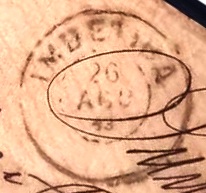
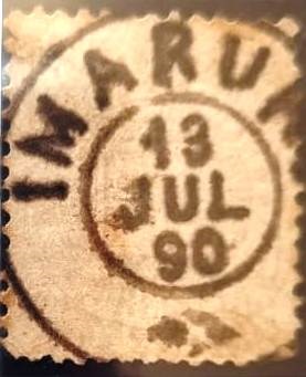
The imperial postmark is ISC-0110a (Coll. Marcio Duarte):
ISC-0110a (MDu) 1885-1891Villiers de l’Ile Adam: Carta (…) da Provincia de Santa Catharina, 1848
Andere Namen: Imarohy, Maruhi
Seit August 1833 bestand die Freguesia de S. João Baptista de Imaruí, die zur Vila de Laguna gehörte und am Nordufer der Imaruí-Lagune, 110 km südlich der Provinzhauptstadt Florianópolis, lag. Im August 1890 wurde Imaruí (wie es heute geschrieben wird) eine eigenständige Vila. Der Name aus der Indigenensprache Tupi-guarani bedeutet Kleine Mücke.
R. Koester schreibt in Carimbologia XXII, dass es dort seit Mai 1881 ein Postamt gab. Dies wird von der regionalen Presse bestätigt:
O Despertador, 08.06.1881
Der kaiserliche Poststempel ist ISC-0110a (Samml. Marcio Duarte):