Categories
Carimbologia H-L

Humildes, Piauí (HPI-0075)

Villiers de l’Ile Adam: Carta (…) da Provincia do Piauhy, 1850

Other names: Alto Longá (1890)

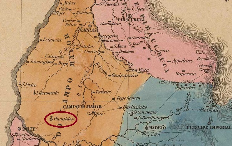
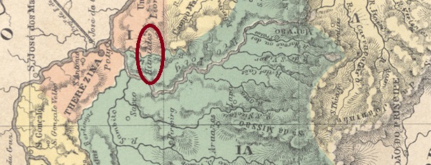
Since August 1870, N. Sra. dos Humildes was the curato of the Freguesia de N. Sra. das Dores, which in turn belonged to the Vila de Teresina. Located on the south bank of the River Gameleira, 80 kilometres east of the provincial capital Teresina, the village became a freguesia in June 1874 and a year later a vila, which was given the name Alto Longá in January 1890. After a period (June 1931 to August 1934) as a district of the Município de Alto, the status of a Município was restored.

As can be seen from the list of imperial post offices (Tabella das Agencias do Correio do Imperio, Rio de Janeiro, 1885), there had been a post office there since 1882. Unfortunately, no imperial postmarks from Humildes have been found to date.

Atlas do Imperio do Brasil, 1868

Andere Namen: Alto Longá (1890)

Seit August 1870 war N. Sra. dos Humildes Curato der Freguesia de N. Sra. das Dores, die ihrerseits zur Vila de Teresina gehörte. Der am Südufer des Flusses Gameleira, 80 km östlich der Provinzhauptstadt Teresina gelegene Ort wurde im Juni 1874 zur Freguesia und ein Jahr später zur Vila, die im Januar 1890 den Namen Alto Longá erhielt. Nach einer Periode (Juni 1931 bis August 1934) als Distrikt des Município de Alto wurde der Status eines Município wiederhergestellt.

Wie aus dem Verzeichnis der kaiserlichen Postämter (Tabella das Agencias do Correio do Imperio, Rio de Janeiro, 1885) hervorgeht, gab es dort seit 1882 ein Postamt. Bisher wurden leider keine kaiserlichen Poststempel aus Humildes gefunden.

Categories
Carimbologia H-L

Herval, Rio Grande do Sul (HRS-0190)

Provincia de São Pedro do Sul, 1847

São João Baptista do Herval (also spelt Erval) was a freguesia of the Vila de Jaguarão on the east bank of the Arroio Grande, 400 km south-west of the provincial capital Porto Alegre, from January 1825. The village was elevated to a Vila in May 1881 and to a Município in June 1972. The name comes from the mate bushes, which were found in large quantities in the area.

The local post office was created in October 1882, as reported in the Rio press:

Gazeta da Tarde/RJ, 19/10/1882

The imperial postmark is VRS-0190a (collect. Fuad Ferreira Fo.)

VRS-0190a (FF) 1886-1898ff

Philatelist Carlos Aldir C. Balata also shows a handwritten cancellation from there:

1887ff (CB)
Atlas do Imperio do Brasil, 1868

São João Baptista do Herval (auch Erval geschrieben) war seit Januar 1825 eine Freguesia der Vila de Jaguarão am Ostufer des Arroio Grande, 400 km südwestlich der Provinzhauptstadt Porto Alegre. Der Ort wurde im Mai 1881 zur Vila und im Juni 1972 zum Município erhoben. Der Name stammt von den Mate-Sträuchern, die in der Gegend in großen Mengen vorkamen.

Die Einrichtung eines örtlichen Postamts wurde im Oktober 1882 beschlossen, wie die Presse von Rio berichtet:

Gazeta da Tarde/RJ, 19.10.1882

Der kaiserliche Poststempel lautet VRS-0190a (Samml. Fuad Ferreira Fo.)

VRS-0190a (FF) 1886-1898ff

Der Philatelist Carlos Aldir C. Balata zeigt auch eine handschriftliche Entwertung von dort:

1887ff (CB)
Categories
Carimbologia H-L

Herculanea, Mato Grosso (HMT-0025)

Carta da Republica dos Estados Unidos do Brazil, 1892

Other names: Belliago, Taquary, Coxim (1898)

See also São José de Herculanea (SMT-0060)

This village has a long but very patchy history, as so often in this province. Founded as Arraial de Belliago (named after the founder) around 1730, it was located on the east bank of the Taquary River, more than 450 km south of the later provincial capital Cuiabá. Later, the name changed to Taquary, until the district was officially named S. José de Herculanea in November 1872, after the former provincial governor Herculano Ferreira Penna (1811-1867). In April 1898, it became the municipality of Coxim, which has been part of the state of Mato Grosso do Sul since October 1977. Coxim is the river that flows into the Taquary around this locality.

Both the Imperial Mail Register (Tabella das Agencias do Correio do Imperio, 1885) and Reinhold Koester list the local post office with founding year 1880, but it could also have been a year later, as can be read in the report of the provincial president of June 1882:

Relatorio do Presidente da Provincia, June 1882

This second date is confirmed by the Rio de Janeiro press. The only imperial postmark to date is HMT-0025a (José A. Junges collection)

HMT-0025a (JJ) 1888
Google Maps

Andere Namen: Belliago, Taquary, Coxim (1898)

Siehe auch São José de Herculanea (SMT-0060)

Diese Ortschaft hat eine lange, aber sehr lückenhafte Geschichte, wie so oft in dieser Provinz. Gegründet als Arraial de Belliago (genannt nach dem Gründer) um 1730, sie lag am Ostufer des Flusses Taquary, über 450 km südlich der späteren Provinzhauptstadt Cuiabá. Später wechselte der Name zu Taquary, bis der Distrikt im November 1872 unter dem Namen S. José de Herculanea offiziell genannt wurde, nach dem ehemaligen Provinzgouverneur Herculano Ferreira Penna (1811-1867). Im April 1898 kam die politische Autonomie als Município von Coxim, der seit Oktober 1977 dem Bundesstaat Mato Grosso do Sul angehört. Coxim heißt der Fluss, der an dieser Stelle in den Taquary mündet.

Sowohl das Verzeichnis der kaiserlichen Postämter (Tabella das Agencias do Correio do Imperio, 1885) als auch Reinhold Koester listen das örtliche Postamt mit Gründungsjahr 1880 auf, aber es könnte auch ein Jahr später gewesen sein, wie aus dem Bericht des Provinzpräsidenten vom Juni 1882 hervorgeht:

Relatorio do Presidente da Provincia, Juni 1882

Dieses zweite Datum wird von der Presse aus Rio bestätigt. Der bisher einzige kaiserliche Poststempel ist HMT-0025a (Samml. José A. Junges)

HMT-0025a (JJ) 1888
Categories
Carimbologia H-L

Harmonia, Rio Grande do Sul (HRS-0185)

colonias.heuser.pro.br

Around 1875, Harmonia became a district of the Vila de S. João do Monte Negro on the west bank of the Caí, 80 kilometres northwest of the provincial capital Porto Alegre. In June 1882, the village became the Freguesia de S. João Nepomuceno da Harmonia and in April 1988 was elevated to the status of Município.

It is assumed that the name comes from a singing society of German settlers.

R. Koester writes in Carimbologia XXI that there had been a post office there since October 1888. This is confirmed by the press in Rio:

Gazeta de Noticias/RJ 06.10.1888

The oldest postmark to date is HRS-0185a (fig. R. Koester, op. cit.):

HRS-0185a (RK) 1908
Google Maps

Um 1875 wurde Harmonia ein Distrito der Vila de S. João do Monte Negro am Westufer des Caí, 80 km nordwestlich der Provinzhauptstadt Porto Alegre. Im Juni 1882 wurde der Ort zur Freguesia de S. João Nepomuceno da Harmonia und im April 1988 zum Município erhoben.

Es wird angenommen, dass der Name von einem Gesangsverein der deutschen Siedler stammt.

R. Koester schreibt in Carimbologia XXI, dass es dort seit Oktober 1888 ein Postamt gab. Dies wird von der Presse in Rio bestätigt:

Gazeta de Noticias/RJ 06.10.1888

Der bisher älteste Poststempel ist HRS-0185a (Abb. R. Koester, op. cit.):

HRS-0185a (RK) 1908