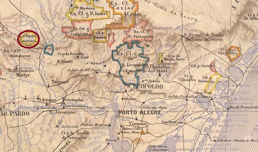
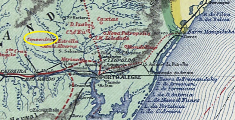
Since April 1874, this place was the parish of Conventos Velhos, which belonged to the Vila de Sto. Antonio da Estrella and was located on the west bank of the Taquari River, 120 kilometres northwest of the provincial capital Porto Alegre. In May 1881 it became the Freguesia de Santo Ignacio dos Conventos and in January 1891 the Vila e Município de Lajeado (as it is written today).
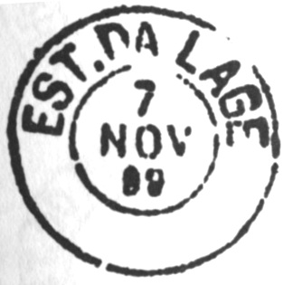
According to the postal bulletin (Boletim Postal) of November 1889, it had been decided the previous month to establish a post office there. It is very unlikely that there are any imperial postmarks from Lageado.
Carta da Republica dos Estados Unidos do Brazil, 1892
Andere Namen: Conventos Velhos
Seit April 1874 war dieser Ort die Pfarrei Conventos Velhos, die zur Vila de Sto. Antonio da Estrella gehörte und am Westufer des Taquari, 120 km nordwestlich der Provinzhauptstadt Porto Alegre, lag. Im Mai 1881 wurde es zur Freguesia de Santo Ignacio dos Conventos und im Januar 1891 zur Vila e Município de Lajeado (wie es heute geschrieben wird).
Wie aus dem Postbulletin (Boletim Postal) vom November 1889 hervorgeht, wurde im Monat zuvor beschlossen, dort ein Postamt einzurichten. Es ist sehr unwahrscheinlich, dass es kaiserliche Poststempel von Lageado gibt.
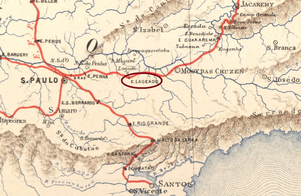
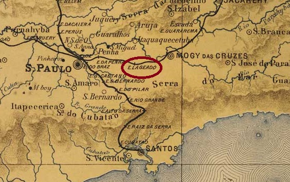
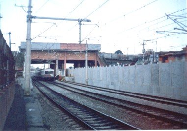
Lageado station was opened in August 1877 (Mário Celso Orsi Jr. writes November 1875) by the railway company E.F. do Norte (later E.F. D. Pedro II), Main Line, and was located 30 km east of the provincial capital of São Paulo. The line was transferred to E.F. Central do Brasil in 1889 and to Rede Ferroviária Federal S.A. in 1975 and belonged to Cia. Paulista de Transportes Metropolitanos/CPTM (estacoesferroviarias.com.br) from 1994 until it was closed in 2000. The station was renamed Carvalho Araújo (a former Central do Brasil director) in September 1924 and Guaianazes in August 1945. Today, the tracks have disappeared and the station building was still used as a restaurant in 2004.
2004 (Photo: Coaraci Camargo, on estacoesferroviarias.com.br)
As R. Koester writes in Carimbologia XXVI, there had been a post office at the station since January 1889. No imperial postmark from Lageado station has yet been found.
J. M. Ribeiro Lisboa: Provincia de São Paulo, 1884
Andere Namen: Carvalho Araújo, Guaianazes (1945)
Der Bahnhof Lageado wurde im August 1877 (Mário Celso Orsi Jr. schreibt November 1875) von der Eisenbahngesellschaft E.F. do Norte (später E.F. D. Pedro II), Hauptlinie, eröffnet und lag 30 km östlich der Provinzhauptstadt São Paulo. Die Strecke ging 1889 an die E.F. Central do Brasil und 1975 an die Rede Ferroviária Federal S.A. über und gehörte von 1994 bis zu ihrer Stilllegung im Jahr 2000 der Cia. Paulista de Transportes Metropolitanos/CPTM (estacoesferroviarias.com.br). Der Bahnhof wurde im September 1924 in Carvalho Araújo (ein ehemaliger Direktor bei Central do Brasil) und im August 1945 in Guaianazes umbenannt. Heute sind die Gleise verschwunden, das Bahnhofsgebäude diente 2004 noch als Restaurant.
2004 (Foto: Coaraci Camargo, auf estacoesferroviarias.com.br)
Wie R. Koester in Carimbologia XXVI schreibt, gab es am Bahnhof seit Januar 1889 ein Postamt. Bisher wurde kein kaiserlicher Poststempel vom Bahnhof Lageado gefunden.
From December 1749, there was a chapel in Arraial da Lage near the source of the river Sto. Antonio, 150 kilometres southwest of the later provincial capital Ouro Preto. In March 1840, the settlement became the Freguesia de N. Sra. da Penha da França do Arraial da Lage, which belonged to the Vila de S. José d’El-Rei. In August 1911, Arraial da Lage became a Vila, which was renamed Município de Resende Costa in September 1923. The name commemorates the landowner and politician José de Resende Costa Filho (1766-1841), who was born there.
Birthplace of Resende Costa (Photo: João Carlos Resende)
Two dates of origin have been found for the local post office. Paula Sobrinho (História Postal de Minas Gerais, Belo Horizonte, 1997) gives May 1884, while Reinhold Koester (Carimbologia XXVI) gives September 1885.
The imperial postmark is LMG-1455a (illustration from the Internet):
LMG-1455a (Delcampe) 1885-1895Atlas do Imperio do Brasil, 1868
Andere Namen: Resende Costa (1923)
Seit Dezember 1749 war eine Kapelle im Arraial da Lage in der Nähe der Quelle des Flusses Sto. Antonio, 150 km südwestlich der späteren Provinzhauptstadt Ouro Preto. Die Siedlung wurde im März 1840 zur Freguesia de N. Sra. da Penha da França do Arraial da Lage, die zur Vila de S. José d’El-Rei gehörte. Im August 1911 wurde Arraial da Lage eine Vila, die im September 1923 in Município de Resende Costa umbenannt wurde. Der Name erinnert an den dort geborenen Großgrundbesitzer und Politiker José de Resende Costa Filho (1766-1841).
Geburtshaus von Resende Costa (Foto: João Carlos Resende)
Für das örtliche Postamt wurden zwei Entstehungsdaten gefunden. Paula Sobrinho (História Postal de Minas Gerais, Belo Horizonte, 1997) nennt den Mai 1884, während Reinhold Koester (Carimbologia XXVI) den September 1885 angibt.
Der kaiserliche Poststempel ist LMG-1455a (Abb. aus dem Internet):
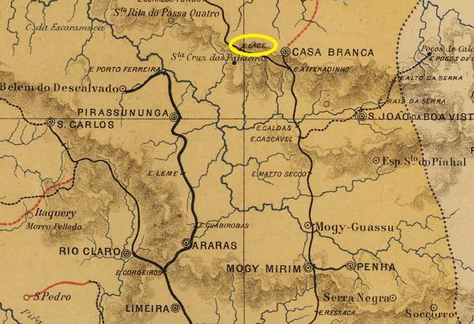
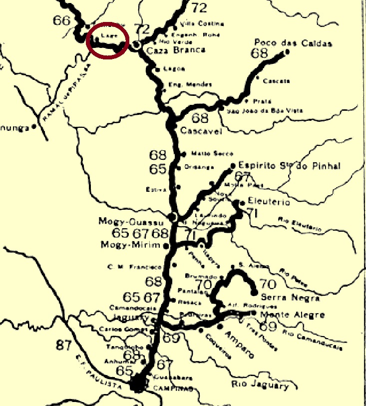
This Lage station was opened in November 1881 by the E.F. Mogyana railway company (Main Line) in the Município de Casa Branca, 240 km north of the provincial capital of São Paulo. It remained so until the line was closed in 1937 and had been in the Município de Sta. Cruz das Palmeiras since March 1885. Today, the tracks have disappeared and the station building was still used as a residential building in 2016 (estacoesferroviarias.com.br).
Around 1910 (Photo: Album da Mogyana, on estacoesferroviarias.com.br)In 2013 (Photo: Sergio Pollini, on estacoesferroviarias.com.br)
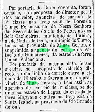
As the press in Rio reported, it was decided in December 1881 to set up a post office in the station:
Gazeta de Noticias/RJ, 18/12/1881
Philatelist Mário Celso Orsi Jr. writes the date January 1886, which is probably a transcription error. The station post office was closed in October 1898, as can be seen from the regional press:
Correio Paulistano, 21/10/1898
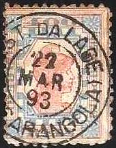
The oldest postmark to date is LSP-0730a (fig. R. Koester, in Carimbologia XXVI):
LSP-0730a (RK) 1883-1886
LSP-0730b also appeared later (fig. Koester, op. cit.):
LSP-0730b (RK) 1885ff-1891
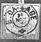
Koester also showed the postmark with the imperial seal LSP-0730c:
LSP-0730c (RK)Cia. Mogyana, 1898 (IBGE)
Dieser Bahnhof Lage wurde im November 1881 von der Eisenbahngesellschaft E.F. Mogyana (Hauptstrecke) eröffnet und lag im Município de Casa Branca, 240 km nördlich der Provinzhauptstadt São Paulo. So blieb es bis zur Stilllegung der Strecke im Jahr 1937. Seit März 1885 befand er sich im Município de Sta. Cruz das Palmeiras. Heute sind die Gleise verschwunden, das Bahnhofsgebäude diente 2016 noch als Wohnhaus (estacoesferroviarias.com.br).
Ca. 1910 (Foto: Album da Mogyana, auf estacoesferroviarias.com.br)2013 (Foto: Sergio Pollini, auf estacoesferroviarias.com.br)
Wie die Presse in Rio berichtete, wurde im Dezember 1881 beschlossen, im Bahnhof ein Postamt einzurichten:
Gazeta de Noticias/RJ, 18.12.1881
Der Philatelist Mário Celso Orsi Jr. schreibt dazu das Datum Januar 1886, was ein Abschreibfehler sein dürfte. Das Bahnhofspostamt wurde im Oktober 1898 geschlossen, wie aus der regionalen Presse hervorgeht:
Correio Paulistano, 21.10.1898
Der bisher älteste Poststempel ist hier LSP-0730a (Abb. R. Koester, in Carimbologia XXVI):
LSP-0730a (RK) 1883-1886
Später erschien auch LSP-0730b (Abb. Koester, op. cit.):
LSP-0730b (RK) 1885ff-1891
Koester zeigte auch den Poststempel mit dem kaiserlichen Siegel LSP-0730c:
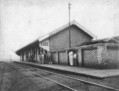
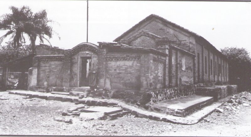
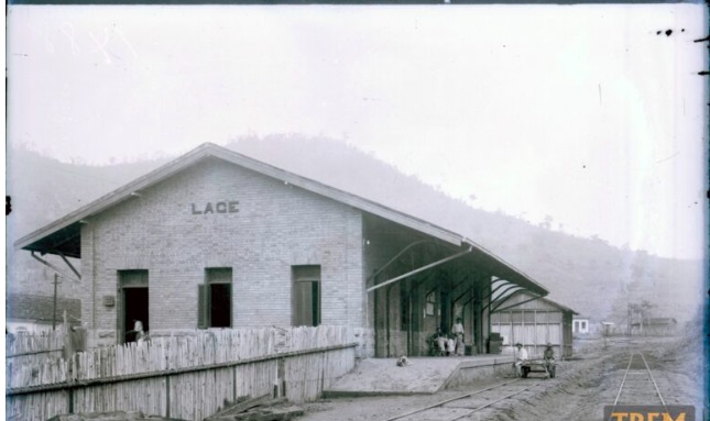
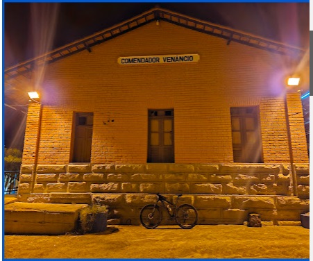
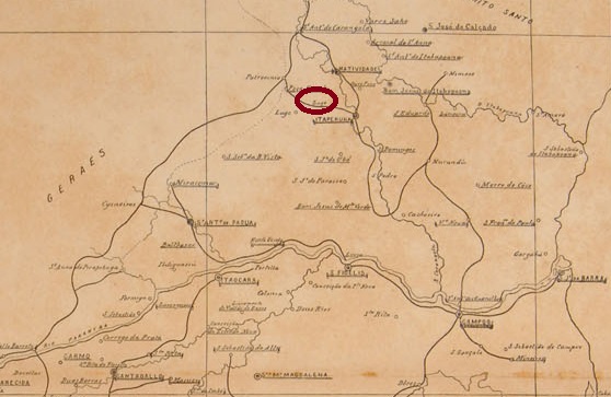
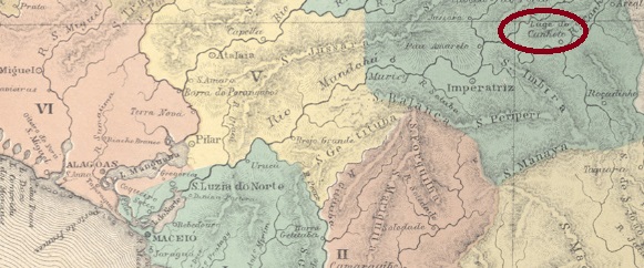
Lage station was opened in October 1884 by the E.F. Carangola railway company (Poço Fundo Branch Line) and was located on the north bank of the Muriaé in the Município de Campos, 320 km north-east of the capital Rio de Janeiro. The area around the railway station belonged to the Vila de Natividade do Itaperuna from November 1885, to the Município de Itaperuna from December 1889 and to the Distrito de Comendador Venâncio from December 1938. Shortly afterwards, the railway station was also renamed Comendador Venâncio. In 1890, the railway line became the property of Cia. Barão de Araruama and in the same year – until its closure in 1974 – it belonged to E.F. Leopoldina (estacoesferroviarias.com.br). Today, the tracks have disappeared and the station building serves as a community hall with a post office.
Around 1940 (photo: tremdedados.com.br)In March 2024 (photo: Michael Prata, on Google Maps)
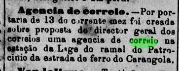
As reported in the regional press, there had been a post office at the station since January 1886:
Monitor Campista, 16/01/1886
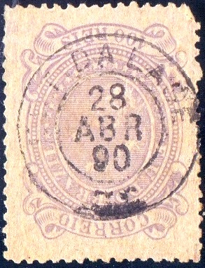
The oldest postmark here to date is LRJ-1075a, shown here in an illustration by Cícero Antonio Almeida (Carimbos Postais – século XIX, Rio de Janeiro, 1989) under no. 764:
LRJ-1075a (MPT 764, RK) 1889
This was followed by the rare LRJ-1075b (illus. Rodrigo Baldassare):
LRJ-1075b (RB) 1890
At the beginning of the Republic, LRJ-1075c also appeared (Fig. agenciaspostais.com.br):
LRJ-1075c (PN) 1892-1893
For postmarks from Freguezia da Lage, 6 km to the south, see FRJ-1095.
Mappa Geographico-Postal do Rio de Janeiro, 1906
Siehe auch Freguezia da Lage (FRJ-1075)
Der Bahnhof Lage wurde im Oktober 1884 von der Eisenbahngesellschaft E.F. Carangola (Zweigbahn Poço Fundo) eröffnet und lag am Nordufer des Muriaé im Município de Campos, 320 km nordöstlich der Hauptstadt Rio de Janeiro. Das Gebiet um den Bahnhof gehörte ab November 1885 zur Vila de Natividade do Itaperuna, ab Dezember 1889 zum Município de Itaperuna und ab Dezember 1938 zum Distrito de Comendador Venâncio. Kurz darauf wurde auch der Bahnhof in Comendador Venâncio umbenannt. Die Bahnlinie ging 1890 in den Besitz der Cia. Barão de Araruama und noch im selben Jahr – bis zu ihrer Stilllegung 1974 – gehörte sie der E.F. Leopoldina (estacoesferroviarias.com.br). Heute sind die Gleise verschwunden, das Bahnhofsgebäude dient als Gemeindesaal mit Postamt.
Um 1940 (Foto: tremdedados.com.br)Im März 2024 (Foto: Michael Prata, auf Google Maps)
Wie die regionale Presse berichtete, gab es seit Januar 1886 ein Postamt am Bahnhof:
Monitor Campista, 16.01.1886
Der bisher älteste Poststempel ist hier LRJ-1075a, hier in einer Abbildung von Cícero Antonio Almeida (Carimbos Postais – século XIX, Rio de Janeiro, 1989) unter Nr. 764:
LRJ-1075a (MPT 764, RK) 1889
Es folgte der seltene LRJ-1075b (Abb. Rodrigo Baldassare):
LRJ-1075b (RB) 1890
Am Anfang der Republik erschien auch LRJ-1075c (Abb. agenciaspostais.com.br):
LRJ-1075c (PN) 1892-1893
Für Poststempel aus der 6 km südlich gelegenen Freguezia da Lage siehe FRJ-1095.
Villiers de l’Ile Adam: Carta (…) das Provincias de Pernambuco, Alagoas e Sergipe, 1848
Another name: Canhoto
See also S. José da Lage (SAL-0205).
This village was formerly a freguesia called Lage do Canhoto, which was located at Vila Nova da Imperatriz on the west bank of the Canhoto River (= left-handed), about 100 km north of the provincial capital Maceió. In July 1876, it rose to a villa, but six years later it was demoted back to a district, now under the name S. José da Lage. The villa status returned in June 1886, and today the municipality of S. José da Laje is written with j.
Two different years were found for the creation of the local post office. Aldo Cardoso (Contribuição para a História dos Correios de Alagoas, Maceió, 1969) writes the quite early year 1835, which may be a misprint. And the Imperial Mail Register (Tabella das Agencias do Correio do Imperio) from 1885 lists the agency from 1872 on, which would be rather plausible. The oldest postmark to date is LAL-0320b (fig. R. Koester, in Carimbologia XXVI):
LAL-0320b (RK) 1885-1889
For postmarks with S. José da Lage see SAL-0205.
Atlas do Imperio do Brasil, 1868
Anderer Name: Canhoto
Siehe auch S. José da Lage (SAL-0205).
Diese Ortschaft war früher eine Freguesia namens Lage do Canhoto, die bei Vila Nova da Imperatriz am Westufer des Flusses Canhoto (= Linkshänder) lag, gut 100 km nördlich der Provinzhauptstadt Maceió entfernt. Im Juli 1876 stieg sie zur Villa auf, aber bereits 6 Jahre später wurde sie zum Distrikt rückgestuft, unter dem Namen S. José da Lage. Der Villa-Status kehrte im Juni 1886 zurück, und heute schreibt sich der Município Laje, mit j.
Zwei Jahresangaben wurden für die Entstehung des örtlichen Postamtes gefunden. Aldo Cardoso (Contribuição para a História dos Correios de Alagoas, Maceió, 1969) schreibt bereits das Jahr 1835, was ein Druckfehler sein mag. Und das Verzeichnis der kaiserlichen Postämter(Tabella das Agencias do Correio do Imperio, Rio de Janeiro, 1885) listet die Agentur ab 1872 auf, was eher plausibel wäre. Der bisher älteste Poststempel ist LAL-0320b (Abb. R. Koester, in Carimbologia XXVI):
LAL-0320b (RK) 1885-1889
Für Poststempel mit S. José da Lage siehe SAL-0205.
Villiers de l’Ile Adam; Carta (…) das Provincias de Pernambuco, Alagoas e Sergipe, 1848
The Freguesia de N. Sra. da Piedade do Lagarto had existed since December 1679 on the west bank of the Rio do Machado, 80 kilometres west of the later provincial capital of Aracaju. In 1698, it became the third oldest Vila in Sergipe and in April 1880 was elevated to town status.
Two dates have been found for the founding of the local post office. Nova Monteiro, in Administrações e Agencias Postaes do Brasil Imperio (Brasil Filatelico/RJ, 1934-5; reprint SPP 1994-1999), writes December 1844, while the Directory of Imperial Post Offices (Tabella das Agencias do Correio do Imperio, Rio de Janeiro, 1885) mentions 1849. However, there was already a postal route through Lagarto in February 1840, as can be seen from the regional press:
Correio Sergipense, 19/02/1840
The only imperial postmark to date is LSE-0105b (fig. Felipe Piccinini):
LSE-0105b (FP) 1881Atlas do Imperio do Brasil, 1868
Seit Dezember 1679 bestand die Freguesia de N. Sra. da Piedade do Lagarto am Westufer des Rio do Machado, 80 km westlich der späteren Provinzhauptstadt Aracaju. Im Jahre 1698 wurde sie zur drittältesten Vila in Sergipe und im April 1880 zur Stadt erhoben.
Für die Gründung des örtlichen Postamtes wurden zwei Daten gefunden. Nova Monteiro nennt in Administrações e Agencias Postaes do Brasil Imperio (Brasil Filatelico/RJ, 1934-5; Reprint SPP 1994-1999) den Dezember 1844, während das Verzeichnis der kaiserlichen Postämter (Tabella das Agencias do Correio do Imperio, Rio de Janeiro, 1885) das Jahr 1849 zeigt. Es gab jedoch bereits im Februar 1840 eine Postroute durch Lagarto, wie aus der regionalen Presse hervorgeht:
Correio Sergipense, 19.02.1840
Der bisher einzige kaiserliche Poststempel ist LSE-0105b (Abb. Felipe Piccinini):
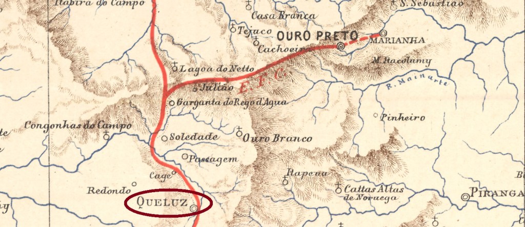
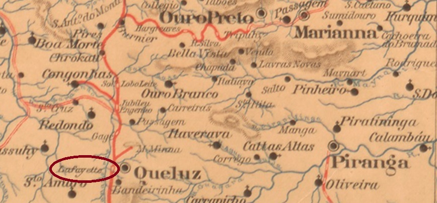
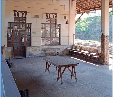
Lafayette station was opened in December 1883 by the railway company E.F. D. Pedro II (Main Line) in the Município de Queluz (today: Conselheiro Lafaiete), 55 km south of the provincial capital Ouro Preto. The line became the property of E.F. Central do Brasil in 1889 and belonged to Rede Ferroviária Federal S.A. from 1975 until its closure in 1996 (estacoesferroviarias.com.br). Today, the tracks still exist and the station building houses the railway museum of the municipality, which has been called Conselheiro Lafaiete since March 1934.
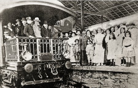
1909: Arrival of President Hermes da Fonseca (photo Laeti Images – Luiz Alberto Jr.)In June 2021 (Photo: Nicolas Logan, on Google Maps)
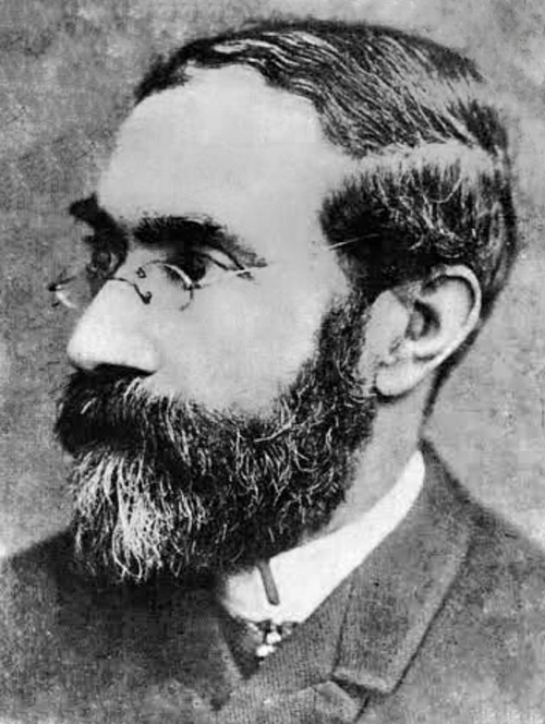
The name commemorates Lafayette Rodrigues Pereira (1834-1917), who was born in Queluz and was Prime Minister of the Empire.
Photo: Wikipedia
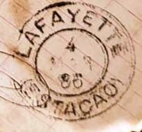
As Paula Sobrinho writes in História Postal de Minas Gerais (Belo Horizonte, 1997), in June 1884 a post office was created at the railway station. The oldest postmark to date is LMG-1450a (José A. Junges Collection):
LMG-1450a (JJ) 1884ff-1887ffEstado de Minas Geraes, 1910
Andere Schreibweisen: Conselheiro Lafayette/Lafaiete
Der Bahnhof Lafayette wurde im Dezember 1883 von der Eisenbahngesellschaft E.F. D. Pedro II (Hauptstrecke) eröffnet und lag im Município de Queluz (heute: Conselheiro Lafaiete), 55 km südlich der Provinzhauptstadt Ouro Preto. Die Strecke ging 1889 in den Besitz der E.F. Central do Brasil über und gehörte von 1975 bis zu ihrer Stilllegung 1996 der Rede Ferroviária Federal S.A. (estacoesferroviarias.com.br). Heute sind die Gleise noch vorhanden, das Bahnhofsgebäude beherbergt das Eisenbahnmuseum der Gemeinde, die seit März 1934 Conselheiro Lafaiete heißt.
1909: Ankunft des Präsidenten Hermes da Fonseca (Foto Laeti Images – Luiz Alberto Jr.)Im Juni 2021 (Foto: Nicolas Logan, auf Google Maps)
Der Name erinnert an Lafayette Rodrigues Pereira (1834-1917), der in Queluz geboren wurde und Premierminister des Kaiserreichs war.
Foto: Wikipedia
Wie Paula Sobrinho in História Postal de Minas Gerais (Belo Horizonte, 1997) schreibt, wurde im Juni 1884 beschlossen, am Bahnhof ein Postamt zu errichten. Der bisher älteste Poststempel ist LMG-1450a (Samml. José A. Junges):
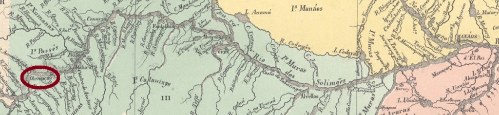
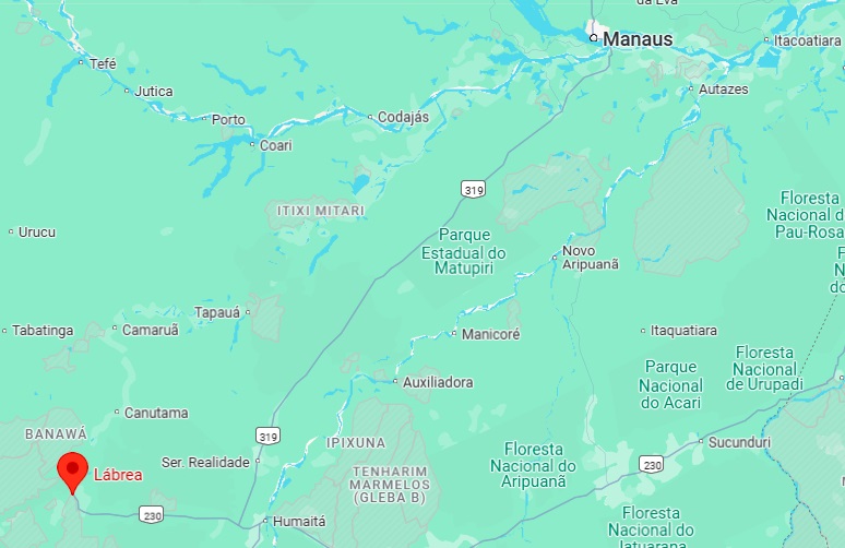
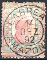
From May 1873, the town was the seat of the Freguesia de N. Sra. da Nazareth do Ituxi, belonged to the Município de Manaus and was located on the south bank of the Purus near the Ituxi estuary, 850 kilometres southwest of Manaus. Lábrea became a vila in May 1881 and a town in October 1894.
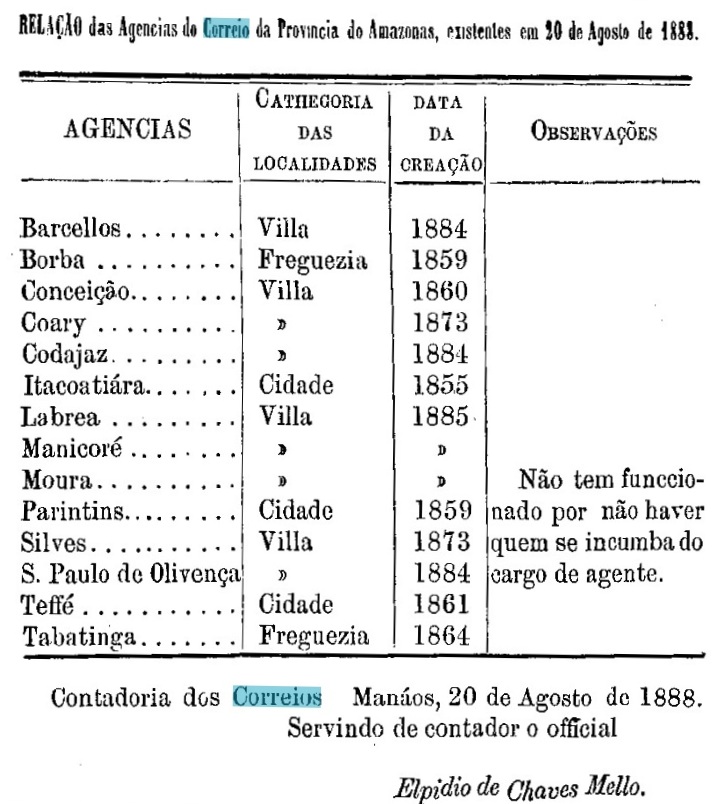
R. Koester writes in Carimbologia XXVI that there had been a post office there since 1884, but the provincial president’s report of 1889 mentions its creation a year later.
Relatorio do Presidente da Provincia, 1889
The only postmark in the 19th century to date is LAM-0055a (image from the Internet):
LAM-0055a (EuclidesWA) 1892Google Maps
Seit Mai 1873 war der Ort Sitz der Freguesia de N. Sra. da Nazareth do Ituxi, gehörte zum Município de Manaus und lag am Südufer des Purus nahe der Ituxi-Mündung, 850 km südwestlich von Manaus. Lábrea wurde im Mai 1881 eine Vila und im Oktober 1894 eine Stadt.
R. Koester schreibt in Carimbologia XXVI, dass es dort seit 1884 ein Postamt gab, aber der Bericht des Provinzpräsidenten von 1889 erwähnt die Gründung erst ein Jahr später.
Relatorio do Presidente da Provincia, 1889
Der bisher einzige Poststempel im 19. Jahrhundert ist LAM-0055a (Abb. aus dem Internet):
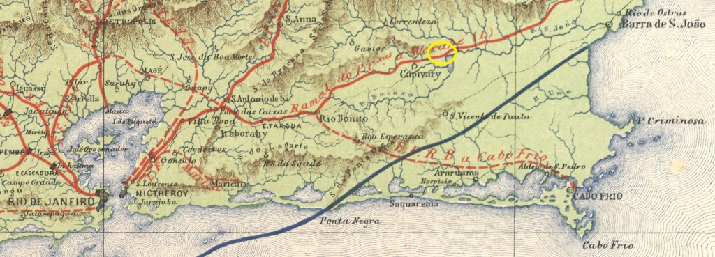
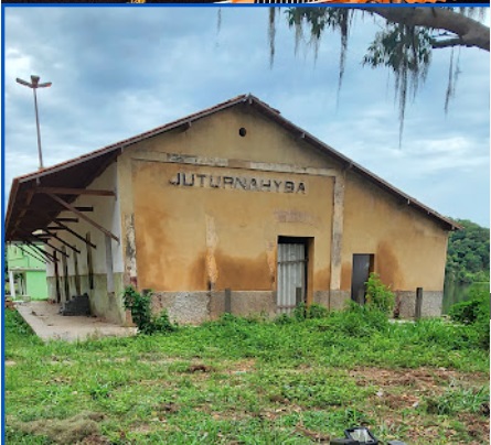
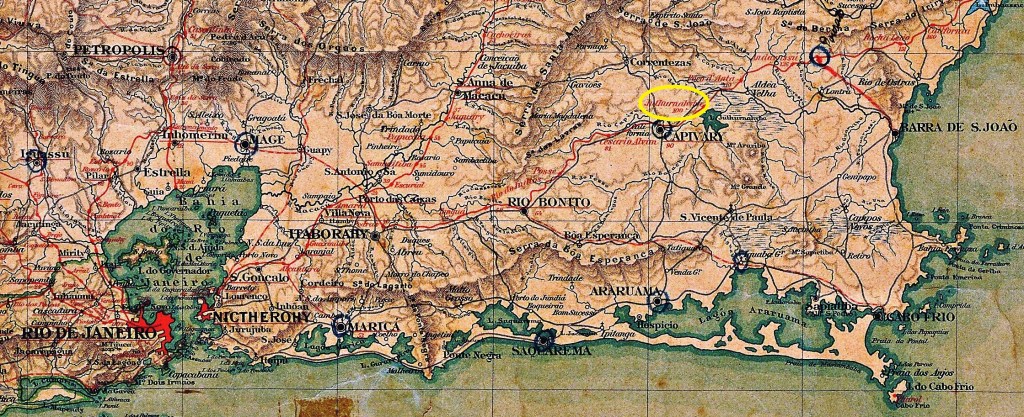
Juturnahyba station was opened in July 1887 by the railway company E.F. do Cantagallo (Rio Bonito Branch) on the northern shore of Lake Juturnaíba in the Município de Capivary, 120 km north-east of the capital Rio de Janeiro. The railway line became the property of E.F. Leopoldina around 1911 and belonged to Rede Ferroviária Federal S.A. from 1975 until its closure in 1996 (estacoesferroviarias.com.br). Since December 1943, the station has been in the Município de Silva Jardim. Today, the tracks have disappeared and the station building serves as a warehouse.
In January 2024 (Photo: Robson Rodrigues, on Google Maps)
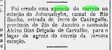
R. Koester writes in Carimbologia XXV that there had been a post office on place since September 1887. This is confirmed by the regional press:
Gazeta de Noticias, 16/09/1987
The imperial postmark is JRJ-2330a (fig. Koester, op. cit.):
JRJ-2330a (RK) 1889Almanak Laemmert, 1892
Aktuelle Schreibweise: Juturnaíba
Der Bahnhof Juturnahyba wurde im Juli 1887 von der Eisenbahngesellschaft E.F. do Cantagallo (Abzweig Rio Bonito) eröffnet und lag am Nordufer des Juturnaíba-Sees im Município de Capivary, 120 km nordöstlich der Hauptstadt Rio de Janeiro. Die Bahnlinie ging um 1911 in den Besitz der E.F. Leopoldina über und gehörte von 1975 bis zur Stilllegung 1996 der Rede Ferroviária Federal S.A. (estacoesferroviarias.com.br). Seit Dezember 1943 befindet sich der Bahnhof im Município de Silva Jardim. Heute sind die Gleise verschwunden, das Bahnhofsgebäude dient als Lagerhalle.
Im Januar 2024 (Foto: Robson Rodrigues, auf Google Maps)
R. Koester schreibt in Carimbologia XXV, dass es dort seit September 1887 ein Postamt gab. Dies wird von der regionalen Presse bestätigt:
Gazeta de Noticias, 16.09.1987
Der kaiserliche Poststempel ist JRJ-2330a (Abb. Koester, op. cit.):