Categories
Carimbologia H-L

Jatahy, Paraná (JPR-0120)

Atlas do Imperio do Brasil, 1868

Other names: São Jerônimo, Jataizinho (1943)

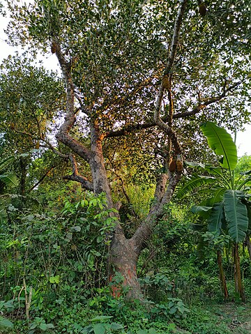
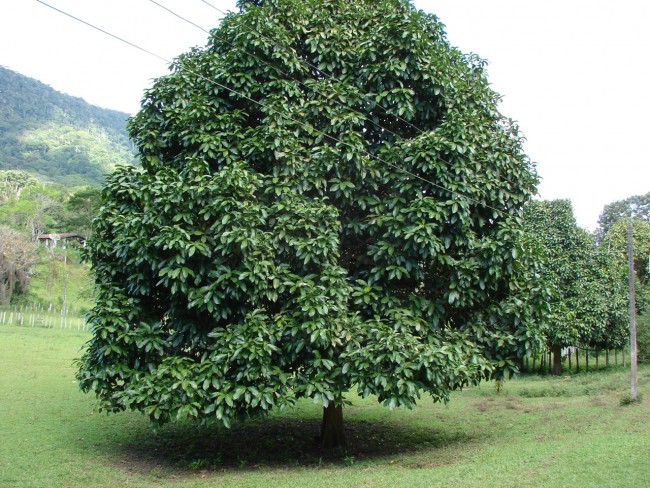
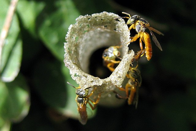
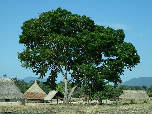
The beautiful indigenous word jataí refers to both a tree from the Fabaceae family (Himenaea courbaril, L.), which is also called jatobá-do-mato in Brazil, and a stingless bee (Tetragonisca angustula), which likes to nest in this tree.

Hymenaea courbaril (Photo: Voytech Zavadil, CC BY-SA 3.0)
Tetragonisca angustula (Photo: demeter)

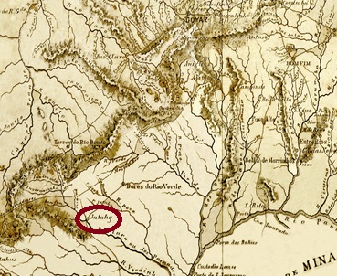
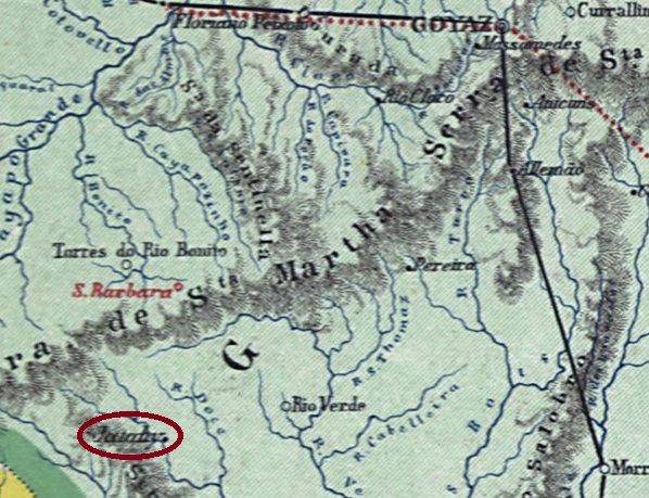
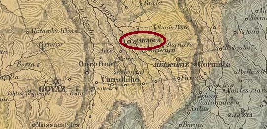
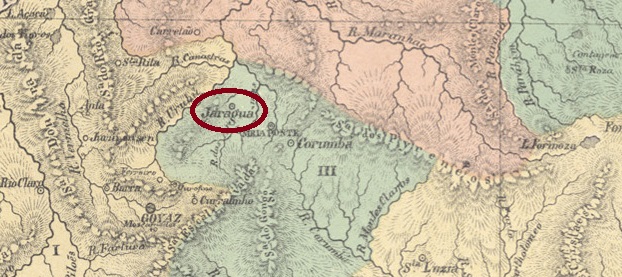
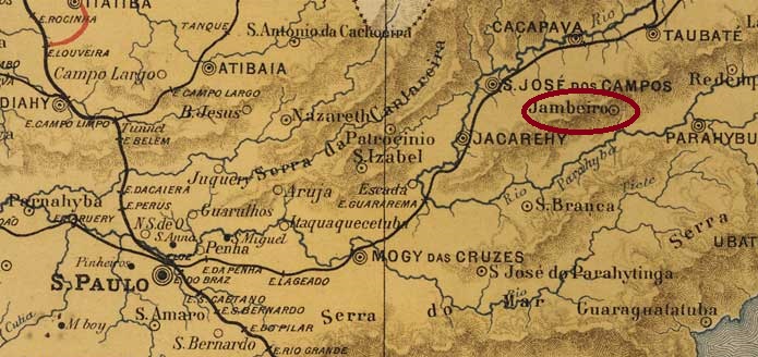
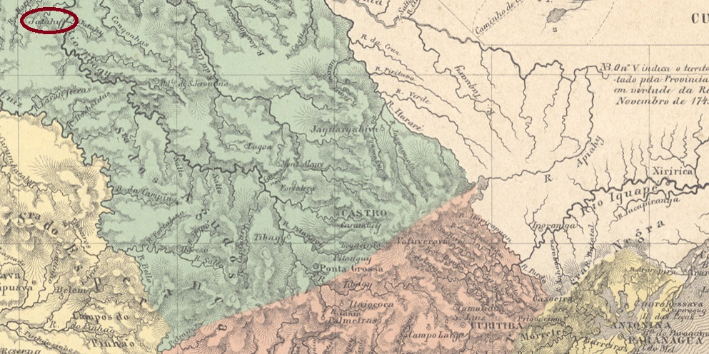
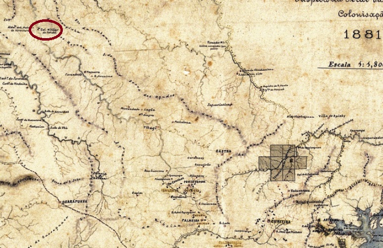
Jatahy was also the name of a military colony founded in January 1851, which belonged to the Vila de Tibagy and was located on the east bank of the Tibagi, 400 kilometres northwest of the provincial capital Curitiba. In April 1872, it was elevated to the Freguesia de N. Sra. da Conceição do Jatahy and incorporated into the Município de Tomazina as a district around 1910. In February 1920 it was elevated to the Município de S. Jerônimo and in March 1929 it became a town. The original place name Jatahy returned in May 1932, but in October 1938 the place was downgraded to a distrito in the Município de S. Jerônimo, before being renamed again in December 1943, this time to Jataizinho, now in the Município de Assaí. It was not until October 1947 that Jataizinho became a município again.

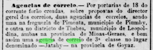
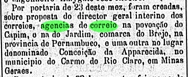
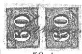
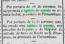
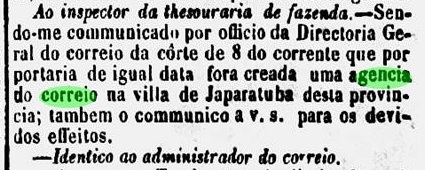
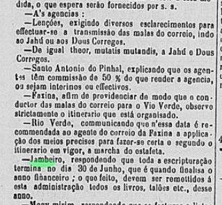
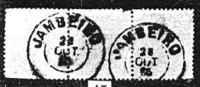
According to the São Paulo press, the local post office was created in May 1887:

Correio Paulistano, 24/05/1887

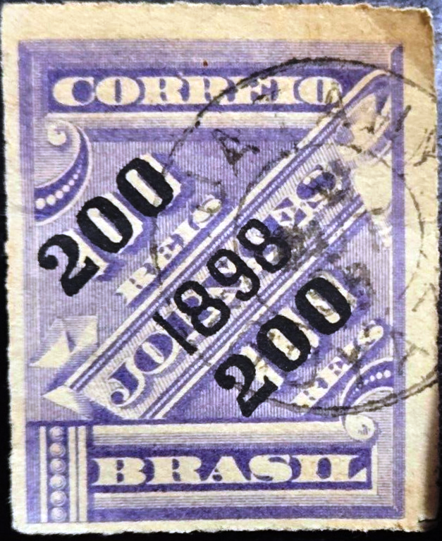
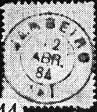
No imperial postmarks have yet been found from Jatahy in the province of Paraná.

Provincia do Paraná, 1881

Andere Namen: São Jerônimo, Jataizinho (1943)

Das schöne indigene Wort jataí bezeichnet sowohl einen Baum aus der Familie der Fabaceae (Himenaea courbaril, L.), der in Brasilien auch jatobá-do-mato genannt wird, als auch eine stachellose Biene (Tetragonisca angustula), die gerne in diesem Baum nistet.

Hymenaea courbaril (Foto: Voytech Zavadil, CC BY-SA 3.0)
Tetragonisca angustula (Foto: demeter)

Jatahy war auch der Name einer im Januar 1851 gegründeten Militärkolonie, die zur Vila de Tibagy gehörte und am Ostufer des Tibagi, 400 km nordwestlich der Provinzhauptstadt Curitiba, lag. Im April 1872 wurde sie zur Freguesia de N. Sra. da Conceição do Jatahy erhoben und um 1910 als Distrikt in das Município Tomazina eingegliedert. Im Februar 1920 erfolgte die Erhebung zum Município de S. Jerônimo und im März 1929 zur Stadt. Der ursprüngliche Ortsname Jatahy kehrte im Mai 1932 zurück, aber im Oktober 1938 wurde der Ort zum Distrito im Município de S. Jerônimo herabgestuft, bevor im Dezember 1943 eine weitere Umbenennung erfolgte, diesmal in Jataizinho, nun im Município de Assaí. Erst im Oktober 1947 wurde Jataizinho wieder ein Município.

Wie aus der Presse von São Paulo hervorgeht, wurde im Mai 1887 die Einrichtung eines örtlichen Postamtes beschlossen:

Correio Paulistano, 24.05.1887

Aus Jatahy in der Provinz Paraná wurden bisher keine kaiserlichen Poststempel gefunden.

Categories
Carimbologia H-L

Jatahy, Goiás (JGO-0095)

Carta da Provincia de Goyaz, 1875

Other names: Paraíso (1882-1885)

The village was originally called Capela do Divino Espírito Santo do Jatahy, belonged to the Vila do Rio Verde and was located on the east bank of the Rio Claro, 380 kilometres southwest of the provincial capital of Goyaz (today: Goiás Velho). In August 1864 it was elevated to the Freguesia de Paraíso do Jatahy and in July 1882 to the Vila de Paraíso. In February 1885 it was renamed Vila de Jatahy, and in May 1895 it became a town.

In August 1881, the creation of a post office was reported in the Rio press:

Jornal do Commercio/RJ, 20/08/1881

The only postmark from the 19th century to date is the double circle JGO-0095b (image from the Internet):

JGO-0095b (EB) 1898
Carta da Republica dos Estados Unidos do Brazil, 1892

Andere Namen: Paraíso (1882-1885)

Der Ort hieß ursprünglich Capela do Divino Espírito Santo do Jatahy, gehörte zur Vila do Rio Verde und lag am Ostufer des Rio Claro, 380 km südwestlich der Provinzhauptstadt Goyaz (heute: Goiás Velho). Im August 1864 wurde er zur Freguesia de Paraíso do Jatahy und im Juli 1882 zur Vila de Paraíso erhoben. Im Februar 1885 erfolgte die Umbenennung in Vila de Jatahy, die im Mai 1895 zur Stadt erhoben wurde.

Im August 1881 wurde in der Presse von Rio die Einrichtung eines Postamtes beschlossen:

Jornal do Commercio/RJ, 20.08.1881

Der bisher einzige Poststempel aus dem 19. Jahrhundert ist der Doppelkreis JGO-0095b (Abbildung aus dem Internet):

JGO-0095b (EB) 1898
Categories
Carimbologia H-L

Jardim, Rio Grande do Norte (JRN-0095)

Atlas do Imperio do Brasil, 1868

Other names: Conceição do Azevedo, Jardim do Seridó (ca. 1892)

The Freguesia de N. Sra. da Conceição do Azevedo, which had existed since September 1856, belonged to the Vila de Acary and was located on the east bank of the Seridó, 240 km south-west of the provincial capital Natal. In September 1858 it was elevated to Vila de Jardim and in August 1874 to a town, which has been called Jardim do Seridó since around 1892 to avoid confusion with Vila de Jardim de Angicos, which was established in Rio Grande do Norte at the time.

As R. Koester writes in Carimbologia XXV, there had been a post office there since May 1887. So far, no imperial postmark could be assigned to this place with certainty.

Carta da Republica dos Estados unidos do Brazil, 1892

Andere Namen: Conceição do Azevedo, Jardim do Seridó (ca. 1892)

Die seit September 1856 bestehende Freguesia de N. Sra. da Conceição do Azevedo gehörte zur Vila de Acary und lag am Ostufer des Seridó, 240 km südwestlich der Provinzhauptstadt Natal. Im September 1858 wurde sie zur Vila de Jardim und im August 1874 zur Stadt erhoben, die seit etwa 1892 Jardim do Seridó heißt, um Verwechslungen mit der damals in Rio Grande do Norte entstandenen Vila de Jardim de Angicos zu vermeiden.

Wie R. Koester in Carimbologia XXV schreibt, gab es dort seit Mai 1887 ein Postamt. Bisher konnte kein kaiserlicher Poststempel mit Sicherheit diesem Ort zugeordnet werden.

Categories
Carimbologia H-L

Jardim, Pernambuco (JPE-0090)

Arthur D. Ribeiro: Estado de Pernambuco, 1924

See also Bello Jardim (BPE-0090)

According to previous research, this locality is identical to Bello Jardim, but had its own postmark in the imperial period (JPE-0090a, fig. R. Koester in Carimbologia XXV), presumably due to a communication error between the municipal, provincial and postal administrations in Rio.

JPE-0090a (RK) 1885-1900

In March 1882, it was decided to open a post office in ‘Jardim’, as reported in the Rio press:

O Globo/RJ, 24/03/1882

However, there was no place called Jardim in the municipality of Brejo. Instead, Bello Jardim was probably meant. In July of this year, the above decision was cancelled and simultaneously a post office was established in Bello Jardim instead:

Diario de Pernambuco, 03/08/1882

In the meantime, the postmark JPE-0090a had been provided and sent to Pernambuco, where it was used despite the incorrect place name.

Carta Corographica da Provincia de Pernambuco, 1880

Siehe auch Bello Jardim (BPE-0090)

Nach den bisherigen Recherchen ist diese Ortschaft identisch mit Bello Jardim, hat aber in der Kaiserzeit einen eigenen Poststempel (JPE-0090a, Abb. R. Koester in Carimbologia XXV) bekommen, vermutlich aufgrund eines Kommunikationsfehlers zwischen Gemeinde-, Provinz- und Postverwaltung in Rio.

JPE-0090a (RK) 1885-1900

Im März 1882 wurde beschlossen, in „Jardim“ ein Postamt zu eröffnen, wie die Presse in Rio berichtete:

O Globo/RJ, 24.03.1882

Allerdings gab es in der Gemeinde Brejo keinen Ort namens Jardim. Stattdessen war wohl Bello Jardim gemeint. Im Juli d. J. wurde obiger Beschluss aufgehoben und stattdessen ein Postamt in Bello Jardim eingerichtet:

Diario de Pernambuco, 03.08.1882

Inzwischen war der Poststempel JPE-0090a fertiggestellt und nach Pernambuco geschickt worden, wo er trotz der falschen Ortsbezeichnung verwendet wurde.

Categories
Carimbologia H-L

Jardim, Ceará (JCE-0185)

Villiers de l’Ile Adam: Carta (…) da Provincia do Ceara, 1849

The village originally belonged to the Vila de Crato and became a Vila in August 1814, but only two months later became the Freguesia de Sto. Antonio do Jardim. It was located on the west bank of the Jardim River, 560 kilometres south of the provincial capital Fortaleza. Jardim has been a town since September 1879.

Jardim post office, ca. 1950 (IBGE)

Nova Monteiro writes in Administrações e Agencias Postaes do Brasil Imperio (Brasil Filatelico/RJ, 1934-5; reprint SPP 1994-1999) that there has been a post office there since August 1866. However, this date is a reopening, as a postal route from Fortaleza to Salvador da Bahia already ran via Jardim in 1843, as can be seen from the journal of the Brazilian Institute of History and Geography:

Revista IHGB 1843, p. 480

As reported by the official press in Rio, the agency was closed in March 1847:

Gazeta Official/RJ, 24/03/1847

So far, no imperial postmark could be assigned to this place with certainty.

Carta da Capitania do Ceara, 1818

Der Ort gehörte ursprünglich zur Vila de Crato und wurde im August 1814 zur Vila, aber erst zwei Monate später zur Freguesia de Sto. Antonio do Jardim. Sie lag am Westufer des Jardim, 560 km südlich der Provinzhauptstadt Fortaleza. Seit September 1879 ist Jardim eine Stadt.

Postamt Jardim, ca. 1950 (IBGE)

Nova Monteiro schreibt in Administrações e Agencias Postaes do Brasil Imperio (Brasil Filatelico/RJ, 1934-5; Reprint SPP 1994-1999), dass es dort seit August 1866 ein Postamt gab. Bei diesem Datum handelt es sich jedoch um eine Wiedereröffnung, da bereits 1843 eine Postroute von Fortaleza nach Salvador da Bahia über Jardim führte, wie aus der Zeitschrift des Brasilianischen Instituts für Geschichte und Geografie hervorgeht:

Revista IHGB, 1843, S. 480

Wie die offizielle Presse von Rio berichtete, wurde die Agentur im März 1847 geschlossen:

Gazeta Official/RJ, 24.03.1847

Bisher konnte kein kaiserlicher Poststempel mit Sicherheit diesem Ort zugeordnet werden.

Categories
Carimbologia H-L

Jaraguá, Goiás (JGO-0090)

Villiers de l’Ile Adam: Carta (…) da Provincia de Goyaz, 1849

It is not known exactly when the chapel of N. Sra. da Penha de Jaraguá was built around 1800; it belonged to the Vila de Meia Ponte and was located on the banks of the Jaraguá, 120 kilometres east of the later provincial capital Goiás (today Goiás Velho). In July 1833, Jaraguá was elevated to a Vila and in July 1882 to a town.

Two creation dates have been found for the local post office. Once in March 1829, as Nova Monteiro writes in Administrações e Agencias Postaes do Brasil Imperio (Brasil Filatelico/RJ, 1934-5; reprint SPP 1994-1999). Then again in 1832, as can be seen from the list of imperial post offices (Tabella das Agencias do Correio do Imperio, Rio de Janeiro, 1885).

The oldest postmark to date is JGO-0090a (fig. Henrique B. Ferreira, in Catálogo ilustrado dos carimbos sobre os olhos-de-boi, Porto Alegre, 2017), which was found on Bull’s Eyes from 1843 – also in red.

JGO-0090a (HBF) 1843ff

In the 50s, the stamps were cancelled by hand, as R. Koester shows in Carimbologia XXV:

1850ff (RK)

JGO-0090c also appeared at the end of the 19th century (illustration from the Internet):

JGO-0090c (EB) 1898ff
Atlas do Imperio do Brasil, 1868

Man weiß nicht genau, wann die Kapelle N. Sra. da Penha de Jaraguá um 1800 errichtet wurde; sie gehörte zur Vila de Meia Ponte und lag am Ufer des Jaraguá, 120 km östlich der späteren Provinzhauptstadt Goiás (heute Goiás Velho). Im Juli 1833 wurde Jaraguá zur Vila und im Juli 1882 zur Stadt erhoben.

Für das örtliche Postamt wurden zwei Gründungsdaten gefunden. Einmal im März 1829, wie Nova Monteiro in Administrações e Agencias Postaes do Brasil Imperio (Brasil Filatelico/RJ, 1934-5; Nachdruck SPP 1994-1999) schreibt. Dann wieder 1832, wie aus dem Verzeichnis der kaiserlichen Postämter (Tabella das Agencias do Correio do Imperio, Rio de Janeiro, 1885) hervorgeht.

Der bisher älteste Poststempel ist JGO-0090a (Abb. Henrique B. Ferreira, in Catálogo ilustrado dos carimbos sobre os olhos-de-boi, Porto Alegre, 2017), der auf Ochsenaugen von 1843 – ebenfalls in rot – gefunden wurde.

JGO-0090a (HBF) 1843ff

In den 50er Jahren wurden die Marken von Hand entwertet, wie R. Koester in Carimbologia XXV zeigt:

1850ff (RK)

Ende des 19. Jahrhunderts erschien auch JGO-0090c (Abb. aus dem Internet):

JGO-0090c (EB) 1898ff
Categories
Carimbologia H-L

Jaqueira (train station/Bahnhof), Pernambuco (JPE-0340)

Caera Corographica da Provincia de Pernambuco, 1880

Jaqueira station was opened in July 1883 by the railway company E.F. Recife ao S. Francisco (Southern Line) and was located on the banks of the Jaqueira in the Município de Palmares, 150 km south-west of the provincial capital Recife. The line changed hands three more times: in 1901 it went to Great Western, in 1950 to Rede Ferroviária do Nordeste and from 1975 until its closure in 1996 it belonged to Rede Ferroviária Federal S.A. (estacoesferroviarias.com.br). The tracks still exist and the restored station building serves as a cultural centre for the municipality.

In September 2022 (Photo: viagemassa, on Google Maps)

The area around the railway station became the Distrito de Jaqueira around 1910 and went to the Município de Maraial in September 1928. It belongs to the Município de Jaqueira since September 1995. This is the Brazilian name of the jackfruit tree from the Moraceae family:

Artocarpus heterophyllus (Lam.), Photo: Nafiur CC BY-SA 4.0

The Rio press reports that there has been a post office at the railway station since May 1884:

Diario do Brazil/RJ, 31/05/1884

Unfortunately, an imperial postmark of Jaqueira has not yet been found.

Rede Ferroviaria de Pernambuco, 1898 (IBGE)

Der Bahnhof Jaqueira wurde im Juli 1883 von der Eisenbahngesellschaft E.F. Recife ao S. Francisco (Südlinie) eröffnet und lag am Ufer des Jaqueira im Município de Palmares, 150 km südwestlich der Provinzhauptstadt Recife. Die Strecke wechselte noch dreimal den Besitzer: 1901 ging sie an die Great Western, 1950 an die Rede Ferroviária do Nordeste und von 1975 bis zu ihrer Stilllegung 1996 gehörte sie der Rede Ferroviária Federal S.A. (estacoesferroviarias.com.br). Die Gleise sind noch vorhanden, das restaurierte Bahnhofsgebäude dient als Kulturzentrum der Gemeinde.

Im September 2022 (Foto: viagemassa, auf Google Maps)

Das Gebiet um den Bahnhof wurde um 1910 zum Distrito de Jaqueira und ging im September 1928 zum Município de Maraial. Seit September 1995 gehört es zum Município de Jaqueira. Dies ist der brasilianische Name des Jackfruchtbaumes aus der Familie der Moraceae:

Artocarpus heterophyllus (Lam.), Foto: Nafiur (CC BY-SA 4.0)

Die Presse von Rio berichtet, dass es seit Mai 1884 ein Postamt am Bahnhof gab:

Diario do Brazil/RJ, 31.05.1884

Ein kaiserlicher Poststempel von Jaqueira wurde bisher leider nicht gefunden.

Categories
Carimbologia H-L

Japaratuba, Sergipe (JSE-0100)

Atlas do Imperio do Brasil, 1868

The Distrito de Japaratuba was founded in January 1811, belonged to the Vila de Sto. Amaro das Brotas and was located on the east bank of the Japaratuba River, 55 kilometres north of the later provincial capital Aracaju. In June 1854, it became the Freguesia de N. Sra. da Saúde de Japaratuba, which in turn belonged to the Vila de Capella and five years later was itself named a Vila. The place name is of indigenous origin and can stand for many beaches with white sand, among others.

As reported in the regional press, there had been a post office since March 1864:

Correio Sergipense, 02/04/1864

The only imperial postmark to date is JSE-0100b (Fig. Felipe Piccinini):

JSE-0100b (FP) 1881-1892

R. Koester also shows a handwritten cancellation from Japaratuba in Carimbologia XXV:

1887 (RK)
Carta da Republica dos Estados Unidos do Brazil, 1892

Der Distrito de Japaratuba wurde im Januar 1811 gegründet, gehörte zur Vila de Sto. Amaro das Brotas und lag am Ostufer des gleichnamigen Flusses, 55 km nördlich der späteren Provinzhauptstadt Aracaju. Im Juni 1854 wurde daraus die Freguesia de N. Sra. da Saúde de Japaratuba, die wiederum zur Vila de Capella gehörte und fünf Jahre später selbst zur Vila ernannt wurde. Der Ortsname ist indigenen Ursprungs und kann u.a. für viele Strände mit weißem Sand stehen.

Wie die regionale Presse berichtete, gab es seit März 1864 ein Postamt:

Correio Sergipense, 02.04.1864

Der bisher einzige kaiserliche Poststempel ist JSE-0100b (Abb. Felipe Piccinini):

JSE-0100b (FP) 1881-1892

R. Koester zeigt in Carimbologia XXV auch eine handschriftliche Entwertung aus Japaratuba:

1887 (RK)
Categories
Carimbologia H-L

Januaria, Minas Gerais (JMG-1415)

Atlas do Imperio do Brasil, 1868

Other names: Other names: Brejo do Amparo, Brejo do Salgado, Porto do Salgado

See also Villa Januária (VMG-1416)

This locality also causes some headaches for researchers, as it has not only been renamed many times, but can also be seen in different places on old maps. What seems certain is that from January 1811 it was the old freguesia of Brejo do Amparo, which belonged to the Vila of Paracatu and was initially located on the right bank of the São Francisco River, about 680 km north of the later provincial capital of Ouro Preto. In June 1833, the place was elevated to a vila, called Villa Januaria de N. Sra. do Amparo do Brejo do Salgado. The Salgado is a tributary of the left bank of the São Francisco, and accordingly the vila was henceforth to be seen on the opposite side of the river. In October 1860, the Vila became a town called Porto do Salgado, but by September 1871, the Município was called Brejo do Amparo, as before. Finally, since September 1884, the municipality has been called Januária, after a daughter of Emperor Pedro I. Presumably, this was the Solomonic solution after a long name dispute between right- and left-bank inhabitants.

At least as far as the origin of the post office is concerned, there is agreement among researchers. Nova Monteiro (Administrações e Agencias Postaes do Brasil Imperio, in Brasil Filatelico/RJ, 1934-5; Reprint SPP 1994-1999), Paula Sobrinho (História Postal de Minas Gerais, Belo Horizonte, 1997) and Reinhold Koester (Carimbologia XXV) unanimously name October 1833. The oldest postmark is VMG-1416a; it also occurs in sepia with dates of use from 1836 to at least 1850 and has already been presented in the RHM catalogue under P-MG-32:

VMG-1416a (RHM P-MG-32) 1836-1850ff

JMG-1415b (fig. Felipe Piccinini) did not appear until around 1887, which suggests that another postmark was used in the meantime, the image of which is still missing:

JMG-1415b (FP) 1887-1889
Villiers de l’Ile Adam: Carta (…) da Provincia de Minas Geraes, 1849

Andere Namen: Brejo do Amparo, Brejo do Salgado, Porto do Salgado

Siehe auch Villa Januária (VMG-1416)

Auch diese Ortschaft bringt einige Kopfzerbrechen für die Forscher, da sie nicht nur oft umbenannt wurde, sondern auch an verschiedenen Stellen auf alten Karten zu sehen ist. Sicher scheint es zu sein, sie war ab Januar 1811 die alte Freguesia von Brejo do Amparo, die der Vila von Paracatu gehörte und zunächst am rechten Ufer des Flusses São Francisco lag, etwa 680 km nördlich der späteren Provinzhauptstadt Ouro Preto entfernt. Im Juni 1833 wurde der Ort zu einer Vila erhoben, die Villa Januaria de N. Sra. do Amparo do Brejo do Salgado hieß. Nun ist der Salgado ein Nebenfluss des linken Ufers vom São Francisco, und dementsprechend war die Vila fortan auf der gegenüberliegenden Flussseite zu sehen. Im Oktober 1860 wurde aus der Vila eine Stadt mit Namen Porto do Salgado, aber schon im September 1871 hieß der Município Brejo do Amparo, wie früher. Schließlich seit September 1884 heißt die Gemeinde Januária, nach einer Tochter des Kaisers Pedro I. Vermutlich war das die salomonische Lösung nach einem langen Namensstreit zwischen Rechts- und Linksufereinwohnern.

Zumindest was die Entstehung des Postamts betrifft, herrscht Einigkeit unter den Forschern. Nova Monteiro (Administrações e Agencias Postaes do Brasil Imperio, in Brasil Filatelico/RJ, 1934-5; Reprint SPP 1994-1999), Paula Sobrinho (História Postal de Minas Gerais, Belo Horizonte, 1997) und Reinhold Koester (Carimbologia XXV) nennen dafür einstimmig den Oktober 1833. Der älteste Poststempel ist VMG-1416a; er kommt auch in sepia mit Verwendungsdaten von 1836 bis in die 50er Jahre vor und wurde bereits im RHM-Katalog unter P-MG-32 vorgestellt:

VMG-1416a (RHM P-MG-32) 1836-1850ff

Erst ab ca. 1887 erschien JMG-1415b (Abb. Felipe Piccinini), was vermuten lässt, dass zwischenzeitlich ein weiterer Poststempel verwendet wurde, dessen Abbildung noch fehlt:

JMG-1415b (FP) 1887-1889
Categories
Carimbologia H-L

Jambeiro, São Paulo (JSP-0710)

Carlos D. Rath: Provincia de São Paulo, 1886

Other names: N. Sra. das Dores de Capivary

The Freguesia de N. Sra. das Dores de Capivary had existed since April 1872. It belonged to the Vila de Caçapava and was located on the Capivari, 120 kilometres east of the provincial capital of São Paulo. In March 1876, it was elevated to a Vila, but changed its name to Jambeiro in May of the following year, presumably to avoid confusion with the other Vila de Capivary in São Paulo. Jambeiro has been a town since July 1898. The name comes from a beautiful tree from the myrtle family (Myrtaceae), which bears juicy, sweet fruit.

Syzygium malaccense (Photo: paraisodasarvores.com.br)

R. Koester writes in Carimbologia XXV that there has been a post office there since around 1878. In fact, it must have already existed in July of the previous year, as can be seen from the regional press:

Correio Paulistano, 17/08/1877

The oldest postmark is the French type JSP-0710a (fig. R. Koester, op. cit.)

JSP-0710a (RK) 1877ff-1884

It was followed by the double circle JSP-0710b (fig. Koester):

JSP-0710b (RK) 1885-1886
J.M. Ribeiro Lisboa: Provincia de São Paulo, 1884

Andere Namen: N. Sra. das Dores de Capivary

Die Freguesia de N. Sra. das Dores de Capivary bestand seit April 1872. Sie gehörte zur Vila de Caçapava und lag am Ufer des Capivari, 120 Kilometer östlich der Provinzhauptstadt São Paulo. Im März 1876 wurde sie zur Vila erhoben, änderte aber im Mai des folgenden Jahres ihren Namen in Jambeiro, vermutlich um Verwechslungen mit der anderen Vila de Capivary in São Paulo zu vermeiden. Jambeiro ist seit Juli 1898 eine Stadt. Der Name stammt von einem schönen Baum aus der Familie der Myrtengewächse (Myrtaceae), der saftige, süße Früchte trägt.

Syzygium malaccense (Foto: paraisodasarvores.com.br)

R. Koester schreibt in Carimbologia XXV, dass es dort seit etwa 1878 ein Postamt gibt. Tatsächlich muss es aber schon im Juli des Vorjahres bestanden haben, wie aus der regionalen Presse hervorgeht:

Correio Paulistano, 17/08/1877

Der älteste Poststempel ist der französische Typ JSP-0710a (Abb. R. Koester, op. cit.)

JSP-0710a (RK) 1877ff-1884

Ihm folgte der Doppelkreis JSP-0710b (Abb. Koester):

JSP-0710b (RK) 1885-1886