Categories
Carimbologia M-N

Manacapurú, Amazonas (MAM-0130)

Atlas do Imperio do Brasil, 1868

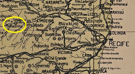
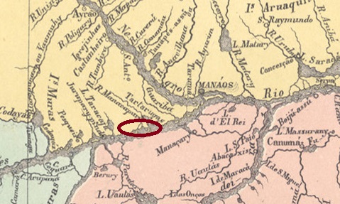
Other names: Manacupuru

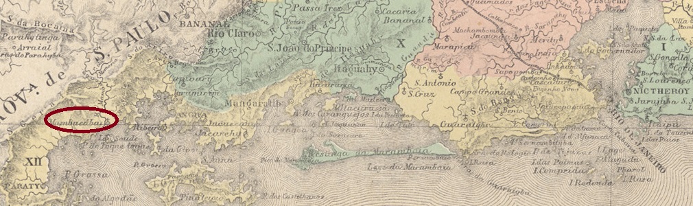
The settlement was founded in 1786 on the site of a former Mura Indian village on the north bank of the Amazon River, 100 kilometres west of the provincial capital Manaus. In August 1865, it was named Freguesia de N. Sra. de Nazaré de Manacapuru and in September 1894 it was elevated to the status of a town. The indigenous name means ‘decorated flower’.

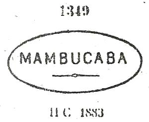
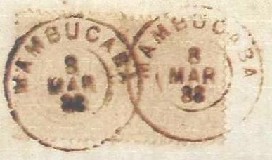
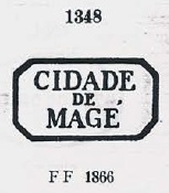
R. Koester writes in Carimbologia XXVII that there had been a post office there since February 1884. However, as this is not listed in the directory of imperial post offices (Tabella das Agencias do Correio do Imperio, Rio de Janeiro, 1885) or in the agency lists of 1888 and 1889, this may be an error. On the other hand, the opening of a post office was announced in April 1890, as can be seen from the postal bulletin (Boletim Postal) of that time.

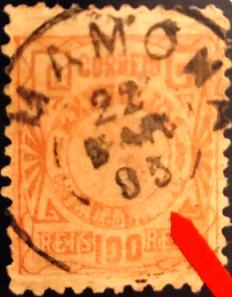
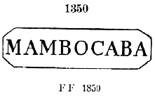
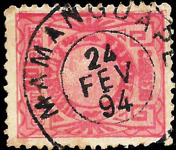
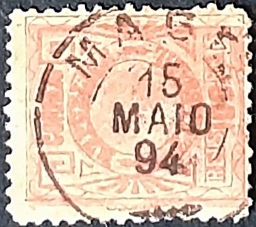
The oldest postmark to date is MAM-0130a (Fuad Ferreira Fo. collection):

MAM-0130a (FF) 1892
Carta da Republica dos Estados Unidos do Brazil, 1892

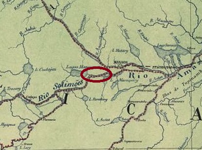
Andere Namen: Manacupuru

Die Siedlung entstand 1786 an der Stelle eines ehemaligen Mura-Indianerdorfs am Nordufer des Amazonas, 100 Kilometer westlich der Provinzhauptstadt Manaus. Im August 1865 wurde sie zur Freguesia de N. Sra. de Nazaré de Manacapuru ernannt und im September 1894 zur Vila erhoben. Der indigene Name bedeutet „Geschmückte Blume”.

R. Koester schreibt in Carimbologia XXVII, dass es dort seit Februar 1884 ein Postamt gab. Da dieses jedoch weder im Verzeichnis der kaiserlichen Postämter (Tabella das Agencias do Correio do Imperio, Rio de Janeiro, 1885) noch in den Agenturenlisten von 1888 und 1889 aufgeführt wird, könnte es sich hierbei um einen Irrtum handeln. Eine Postamteröffnung wurde hingegen im April 1890 bekannt gegeben, wie aus dem damaligen Postbulletin (Boletim Postal) hervorgeht.

Der bisher älteste Poststempel ist MAM-0130a (Samml. Fuad Ferreira Fo.):

MAM-0130a (FF) 1892
Categories
Carimbologia M-N

Mamonas, Bahia (MBA-0890)

Estado da Bahia, 1913

Other names: Santa Maria do Ouro

Here we are once again dealing with a town that has disappeared from the map. Arraial de Santa Maria do Ouro existed around 1850 on the eastern bank of the Riacho Santa Rosa around Vila de Minas do Rio de Contas, 700 kilometres west of the provincial capital Salvador da Bahia. Today, the region is known as Chapada Diamantina. At that time, gold and gemstone deposits attracted many adventurers, and later also bandits and corrupt politicians. They wreaked havoc until all the valuable minerals were exhausted and the town experienced economic decline. In 1878, the settlement known as Mamonas came under the jurisdiction of Vila de Bom Jesus do Rio de Contas. And so it has remained to this day, after the município was renamed twice: in March 1931 to Anchieta and in December 1943 to Piatã.

Mamona is the Brazilian name for a tree of the spurge family (Euphorbiaceae).

Ricinus Communis, L. (Photo: Juan Carlos F. Mata, CC BY-SA 4.0)

According to the Postbulletiin (Boletim Postal), there has been a post office in the area since May 1889.

Boletim Postal, 1889

The only postmark from the 19th century is MBA-0890a (Fig. Jorge L. Pedreira), where the place name reads Mamona:

MBA-0890a (JLP) 1895
Google Maps

Andere Namen: Santa Maria do Ouro

Hier haben wir es wieder mit einer Ortschaft zu tun, die heute von der Landkarte verschwunden ist. Der Arraial de Santa Maria do Ouro bestand um 1850 am Ostufer des Riacho Santa Rosa im Gebiet der Vila de Minas do Rio de Contas, 700 Kilometer westlich der Provinzhauptstadt Salvador da Bahia. Die Region ist heute als Chapada Diamantina bekannt. Damals lockten Gold- und Edelsteinvorkommen viele Abenteurer an, später auch Banditen und korrupte Politiker. Sie trieben ihr Unwesen, bis alle wertvollen Mineralien erschöpft waren und der Ort seinen wirtschaftlichen Niedergang erlebte. 1878 ging die als Mamonas bekannte Siedlung unter die Zuständigkeit der Vila de Bom Jesus do Rio de Contas. Und so blieb es bis heute, nach zweimaliger Umbenennung des Município: im März 1931 in Anchieta und im Dezember 1943 in Piatã.

Mamona ist der brasilianische Name für den Wunderbaum, einen Wolfsmilchgewächs (Euphorbiaceae).

Ricinus Communis, L. (Foto: Juan Carlos F. Mata, CC BY-SA 4.0)

Wie aus dem Postbulletin (Boletim Postal) hervorgeht, gab es vor Ort ein Postamt seit Mai 1889:

Boletim Postal, 1889

Der bisher einzige Poststempel im 19. Jahrhundert ist MBA-0890a (Abb. Jorge L. Pedreira), hier lautet der Ortsname Mamona:

MBA-0890a (JLP) 1895
Categories
Carimbologia M-N

Mambucaba, Rio de Janeiro (MRJ-0705)

Villiers de l’Ile Adam: Carta (…) da Provincia do Rio de Janeiro, 1850

Mambucaba (previously also often spelled Mambocaba) was, since July 1808, the Parish of Nossa Senhora do Rosário de Mambucaba and belonged to the town of Angra dos Reis. The town was located at the mouth of the Mambucaba River, now also called Perequê, 220 km west of the capital Rio de Janeiro. Around 1890, Mambucaba became a district of Angra dos Reis and remains part of it to this day.

According to Nova Monteiro, there had been a post office there since December 1831, as described in Administrações e Agencias Postaes do Brasil Imperio (Brasil Filatelico/RJ, 1934–1935; reprinted by SPP 1994–1999). The oldest postmark to date is MRJ-0705a, which was assigned the number 1350 by Paulo Ayres in the Catálogo de Carimbos Brasil-Império (S. Paulo, 1937, 1942):

MRJ-0705a (P.A. 1350) 1843ff-1866ff

Its successor, MRJ-0705b, was also shown by P. Ayres, this time with the number 1349:

MRJ-0705b (P.A. 1349) 1866ff-1883ff

At the end of the 19th century, MRJ-0705c (fig. Paulo R. Risi) also appeared:

MRJ-0705c (PRR) 1883-1898

R. Koester also showed the postmark with the imperial seal MRJ-0705d at Carimbologia XXVII:

MRJ-0705d (RK)

James Dingler and Klerman W. Lopes presented three blank postmarks from Mambucaba in Mute Cancellations of the Brazil Empire / Carimbos Mudos do Brasil Império (Brazilian Philatelic Association, Rio de Janeiro, 2000):

BPA 2337 – 2339 – 2340
Atlas do Imperio do Brasil, 1868

Mambucaba (früher oft auch Mambocaba geschrieben) war ab Juli 1808 die Freguesia de Nossa Senhora do Rosário de Mambucaba und gehörte zur Vila de Angra dos Reis. Der Ort lag an der Mündung des Mambucaba, der heute auch Perequê heißt, 220 km westlich der Hauptstadt Rio de Janeiro. Um 1890 wurde Mambucaba ein Distrikt von Angra dos Reis und ist bis heute Teil davon.

Laut Nova Monteiro gab es dort seit Dezember 1831 ein Postamt, wie in Administrações e Agencias Postaes do Brasil Imperio (Brasil Filatelico/RJ, 1934–1935; Nachdruck SPP 1994–1999) beschrieben. Der bisher älteste Poststempel ist MRJ-0705a, der von Paulo Ayres in Catálogo de Carimbos Brasil-Império (S. Paulo, 1937, 1942) die Nr. 1350 erhielt:

MRJ-0705a (P.A. 1350) 1843ff-1866ff

Sein Nachfolger MRJ-0705b wurde ebenfalls durch P. Ayres gezeigt, diesmal mit Nr. 1349:

MRJ-0705b (P.A. 1349) 1866ff-1883ff

Gegen Ende des 19. Jahrhunderts erschien auch MRJ-0705c (Abb. Paulo R. Risi):

MRJ-0705c (PRR) 1883-1898

R. Koester zeigte auch in Carimbologia XXVII den Poststempel mit dem kaiserlichen Siegel MRJ-0705d:

MRJ-0705d (RK)

James Dingler und Klerman W. Lopes haben in Mute Cancellations of the Brazil Empire / Carimbos Mudos do Brasil Império (Brazil Philatelic Association, Rio de Janeiro, 2000) drei stumme Stempel aus Mambucaba vorgestellt :

BPA 2337 – 2339 – 2340
Categories
Carimbologia M-N

Mamanguape, Paraíba (MPB-0150)

Atlas do Imperio do Brasil, 1868

This settlement was an Indian village conquered in the 16th century on the north bank of the Mamanguape River, 50 kilometres northwest of what would later become the provincial capital of Parahyba do Norte (now João Pessoa). It probably became the Freguesia de S. Pedro e S. Paulo de Mamanguape in the early 19th century, which became a vila in January 1839 and a city in October 1855. The indigenous name from the Potiguar language means ‘at the drinking water source’.

Nova Monteiro writes in Administrações e Agencias Postaes do Brasil Imperio (Brasil Filatelico/RJ, 1934-5; reprinted by SPP 1994-1999) that there had been a post office there since May 1829. The only postmark from the 19th century to date is MPB-0150b (image from the Internet):

MPB-0150b (EB) 1889-1905
Villiers de l’Ile Adam: Carta (…) das Provincias do Rio Grande do Norte e Parahiba, 1848

Diese Ortschaft war ein im 16. Jahrhundert erobertes Indianerdorf am Nordufer des Mamanguape, 50 Kilometer nordwestlich der späteren Provinzhauptstadt Parahyba do Norte (heute João Pessoa). Vermutlich wurde sie im frühen 19. Jahrhundert zur Freguesia de S. Pedro e S. Paulo de Mamanguape, die im Januar 1839 zur Vila und seit Oktober 1855 zur Stadt wurde. Der indigene Name aus der Potiguar-Sprache bedeutet „an der Trinkwasserstelle”.

Nova Monteiro schreibt in Administrações e Agencias Postaes do Brasil Imperio (Brasil Filatelico/RJ, 1934-5; Reprint SPP 1994-1999), dass es dort seit Mai 1829 ein Postamt gab. Der bisher einzige Poststempel im 19. Jahrhundert ist MPB-0150b (Abb. aus dem Internet):

MPB-0150b (EB) 1889-1905

Categories
Carimbologia M-N

Malhadinha, Pernambuco (MPE-0820)

Carta Corographica da Provincia de Pernambuco, 1880

Around 1890, Malhadinha, which was probably the name of a fazenda in the region, became a district of Vila de Limoeiro, located 120 kilometres west of the capital Recife. In December 1938, the place name was changed to Cumaru. Cumaru has been an independent município since December 1963. The name, which comes from the Tupi-Guaraní language, supposedly means ‘inedible food’.

According to the Rio press, there has been a post office there since August 1884:

Diario do Brazil/RJ, 15 August 1884

No imperial postmark from Malhadinha has been seen to date.

Arthur D. Ribeiro: Estado de Pernambuco, 1924

Andere Namen: Cumaru (1938)

Um 1890 wurde Malhadinha, der wohl der Name einer Fazenda in der Region war, ein Distrikt der Vila de Limoeiro, die 120 Kilometer westlich der Hauptstadt Recife lag. Im Dezember 1938 wurde der Ortsname in Cumaru geändert. Seit Dezember 1963 ist Cumaru ein selbstständiger Município. Der Name aus dem Tupi-Guaraní bedeutet angeblich „ungenießbares Essen”.

Wie aus der Rio-Presse hervorgeht, gab es dort seit August 1884 ein Postamt:

Diario do Brazil/RJ, 15.08.1884

Bisher wurde kein kaiserlicher Poststempel aus Malhadinha gesehen.

Categories
Carimbologia M-N

Maioridade, Rio Grande do Norte (MRN-0185)

Villiers de l’Ile Adam: Carta (…) das Provincias do Rio Grande e Parahiba, 1848

Other names: Serra do Martins, Imperatriz, Martins (1890)

See also Imperatriz (IRN-0090)

Maioridade in north-east Brazil also went through several place names for political reasons. From November 1840 it was the Freguesia de N. Sra. da Conceição da Serra do Martins, which belonged to the Vila de Portalegre and was located on the mountain range of the same name 380 kilometres west of the provincial capital Natal. In November 1841, it became Vila da Maioridade to celebrate the (premature) coming of age of Emperor D. Pedro II, who was not yet 16 years old at the time. In October 1847, it was elevated to the status of a town: Cidade de Imperatriz. Since the beginning of the Republic, in February 1890, the old name Município de Martins has been used again.

According to R. Koester (Carimbologia XXII), there is also said to have been a post office here since April 1818, even before Brazil’s independence. This information has not yet been confirmed; it is more likely that it was opened later. There are also no known imperial postmarks from this location.

Atlas do Imperio do Brasil, 1868

Andere Namen: Serra do Martins, Imperatriz, Martins (1890)

Siehe auch Imperatriz (IRN-0090)

Diese Maioridade im Nordosten Brasiliens hat aus politischen Gründen mehrere Ortsnamen durchlaufen. Seit November 1840 war sie die Freguesia de N. Sra. da Conceição da Serra do Martins, die zur Vila de Portalegre gehörte und am gleichnamigen Gebirge 380 km westlich der Provinzhauptstadt Natal lag. Im November 1841 wurde sie zur Vila da Maioridade, um die (verfrühte) Volljährigkeit des Kaisers D. Pedro II. zu feiern, der zu diesem Zeitpunkt noch keine 16 Jahre alt war. Im Oktober 1847 wurde sie zur Stadt erhoben: Cidade de Imperatriz. Seit Beginn der Republik, im Februar 1890, ist der alte Name Município de Martins wieder gültig.

Nach R. Koester (Carimbologia XXII) soll es auch hier seit April 1818, also noch vor der Unabhängigkeit Brasiliens, ein Postamt gegeben haben. Diese Angabe konnte bisher nicht bestätigt werden, wahrscheinlicher ist eine spätere Inbetriebnahme. Auch sind bisher keine kaiserlichen Poststempel aus diesem Ort bekannt.

Categories
Carimbologia M-N

Magé, Rio de Janeiro (MRJ-0700)

Colton & Colton: Provincia do Rio de Janeiro, 1866

The settlement of Magepe existed since 1565 on the eastern bank of the Magé River, 60 kilometres north of the future capital Rio de Janeiro. In January 1696, it became the parish of Nossa Senhora da Piedade de Magé, which became a small town in June 1789 and a city in October 1857.

Nova Monteiro writes in ‘Administrações e Agencias Postaes do Brasil Imperio’ (Brasil Filatelico/RJ, 1934-5; reprinted by SPP 1994-1999) that there had been a post office there since December 1829. The oldest postmark is MRJ-0700a (illustration in the RHM catalogue):

MRJ-0700a (RHM) 1843ff

This was followed by MRJ-0700b, which was given the number 1348 by Paulo Ayres in Catálogo de Carimbos Brasil-Império (S. Paulo, 1937, 1942):

MRJ-0700b (P.A. 1348) 1866ff

P. Ayres also showed the following cancel, MRJ-0700c, this time with number 1151:

MRJ-0700c (P.A. 1151) 1878ff

Then came the double circle MRJ-0700d (Fig. agenciaspostais.com.br):

MRJ-0700d (PN) 1878-1887

At the end of the Empire, MRJ-0700e (Fig. Luiz C. Fritzen) also appeared, which also exists in blue:

MRJ-0700e (LCF) 1889-1894

The collection of Jacques R. Benchimol also presents a mute postmark that was used in 1882:

1882 (JB)
Villiers de l’Ile Adam: Carta (..) da Provincia do Rio de Janeiro, 1850

Die Siedlung Magepe bestand seit 1565 am Ostufer des Magé, 60 Kilometer nördlich der späteren Hauptstadt Rio de Janeiro. Im Januar 1696 wurde sie zur Freguesia de Nossa Senhora da Piedade de Magé, die im Juni 1789 zur Vila und diese im Oktober 1857 zur Stadt wurde.

Nova Monteiro schreibt in ‘Administrações e Agencias Postaes do Brasil Imperio’ (Brasil Filatelico/RJ, 1934-5; reprint SPP 1994-1999), dass es dort seit Dezember 1829 ein Postamt gab. Der älteste Poststempel ist MRJ-0700a (Abb. RHM-Katalog):

MRJ-0700a (RHM) 1843ff

Es folgte MRJ-0700b , der von Paulo Ayres im Catálogo de Carimbos Brasil-Império (S. Paulo, 1937, 1942) die Nr. 1348 erhielt:

MRJ-0700b (P.A. 1348) 1866ff

P. Ayres zeigte ebenfalls den Folgestempel MRJ-0700c, diesmal mit Nr. 1151:

MRJ-0700c (P.A. 1151) 1878ff

Danach kam der Doppelkreis MRJ-0700d (Abb. agenciaspostais.com.br):

MRJ-0700d (PN) 1878-1887

Gegen Ende des Kaiserreichs erschien auch MRJ-0700e (Abb. Luiz C. Fritzen), der auch in Blau vorkommt:

MRJ-0700e (LCF) 1889-1894

Aus der Sammlung von Jacques R. Benchimol stammt auch ein stummer Poststempel, der 1882 verwendet wurde:

1882 (JB)
Categories
Carimbologia M-N

Madre de Deus do Turvo, Minas Gerais (MMG-1530)

Provincia de Minas Geraes, 1873

Other names: Cianita, Madre de Deus de Minas (1953)

The Freguesia de Madre de Deus do Rio Grande existed since July 1859 and belonged to the Vila de Aiuruoca. It was located on the north bank of the Rio Grande, 210 kilometres southwest of the provincial capital Ouro Preto. In July 1864, it was subordinated to the Freguesia of Vila Bella do Turvo. In September 1923, it became the district of Cianita. This is the Portuguese name for kyanite, a mineral commonly found in the region. The place name changed, then as a municipality, to Madre de Deus de Minas in December 1953.

Kyanite (photo: Francisco M. Ruiz Contreras, CC BY SA 2.0)

As reported by the Rio press, it was decided in December 1881 to establish a post office there.

Gazeta de Noticias/RJ, 18 December 1881

However, no imperial postmark from Madre de Deus do Turvo has been seen to date.

Minas Geraes, 1910

Andere Namen: Cianita, Madre de Deus de Minas (1953)

Die Freguesia de Madre de Deus do Rio Grande bestand seit Juli 1859 und gehörte zur Vila de Aiuruoca. Sie lag am Nordufer des Rio Grande, 210 Kilometer südwestlich der Provinzhauptstadt Ouro Preto. Im Juli 1864 wurde sie als Freguesia der Vila Bella do Turvo untergeordnet. Im September 1923 wurde sie zum Distrikt Cianita. Dies ist die portugiesische Bezeichnung für Kyanit, ein in der Region häufig vorkommendes Mineral. Seit Dezember 1953 besteht der Município de Madre de Deus de Minas.

Kyanit (Foto: Francisco M. Ruiz Contreras, CC BY SA 2.0)

Wie die Presse aus Rio bekannt gab, wurde im Dezember 1881 beschlossen, vor Ort ein Postamt einzurichten.

Gazeta de Noticias/RJ, 18.12.1881

Bisher wurde jedoch kein kaiserlicher Poststempel aus Madre de Deus do Turvo gesehen.

Categories
Carimbologia M-N

Madre de Deus do Angu, Minas Gerais (MMG-3380)

Villiers de l’Ile Adam: Carta (…) da Provincia de Minas Geraes, 1849

See also Angustura (AMG-0080)

The word Angu has African origins and means thick porridge (usually made of cassava, maize or also bananas). The chapel of N. Sra. da Madre de Deus do Angu was built in March 1841 on the south bank of the (presumably viscous) Angu River and was in the Município of Rio Pomba, 250 km south of the provincial capital Ouro Preto. The place was elevated to freguesia status in July 1857 and was given the name Madre de Deus d’Angustura in October 1883, when it changed to the Município of Além Parahyba.

Two dates of origin were found for the local post office. First on 5 April 1860, as Paula Sobrinho writes in História Postal de Minas Gerais (Belo Horizonte, 1997). This could be a transcription error, because the second date is exactly 6 years later, on 5 April 1866, as several sources report. However, the agency did not start operations until December of that year, as a note from the Rio press reveals:

Jornal do Commercio/RJ, 05.12.1866

The oldest postmark to date is MMG-3380a (Fuad Ferreira Fo. collection):

MMG-3380a (FF) 1877

James Dingler and Klerman W. Lopes listed the mute cancellation above with number 743 in Mute Cancellations of the Brazil Empire / Carimbos Mudos do Brasil Império (Brazil Philatelic Association, Rio de Janeiro, 2000):

BPA 743 (1877)

For postmarks with place name Angustura see AMG-0080.

Atlas do Imperio do Brasil, 1868

Siehe auch Angustura (AMG-0080)

Das Wort Angu hat einen afrikanischen Ursprung und bedeutet Dicker Brei (meist aus Maniok, Mais oder auch Bananen). Die Kapelle von N. Sra. da Madre de Deus do Angu wurde im März 1841 am Südufer des (vermutlich zähfließenden) Flusses Angu errichtet und lag im Município von Rio Pomba, 250 km südlich der Provinzhauptstadt Ouro Preto entfernt. Der Ort wurde im Juli 1857 zur Freguesia erhoben und erhielt im Oktober 1883 den Namen Madre de Deus d’Angustura, als er zum Município von Além Parahyba wechselte.

Zwei Entstehungstermine wurden fürs örtliche Postamt gefunden. Zuerst am 5. April 1860, wie Paula Sobrinho in História Postal de Minas Gerais (Belo Horizonte, 1997) schreibt. Dies könnte ein Abschreibfehler sein, denn der zweite Termin liegt genau 6 Jahre später, am 5. April 1866, wie mehrere Quellen belegen. Allerdings nahm die Agentur den Betrieb erst im Dezember d. J., wie eine Meldung aus der Rio-Presse verrät:

Jornal do Commercio/RJ, 05.12.1866

Der bisher älteste Poststempel ist MMG-3380a (Samml. Fuad Ferreira Fo.):

MMG-3380a (FF) 1877

James Dingler und Klerman W. Lopes haben in Mute Cancellations of the Brazil Empire / Carimbos Mudos do Brasil Império (Brazil Philatelic Association, Rio de Janeiro, 2000) den obigen stummen Poststempel mit Nr. 743 aufgeführt:

BPA 743 (1877)

Für Poststempel mit dem neuen Ortsnamen Angustura siehe AMG-0080.

Categories
Carimbologia M-N

Macuco (train station/Bahnhof), Rio de Janeiro MRJ-1805

Estrada de Ferro Central do Brasil, 1890

Macuco Station was opened in September 1876 by the E.F. do Cantagallo railway company. It was located near the north bank of the Rio Grande in the municipality of Cantagallo, 200 kilometres northeast of the capital Rio de Janeiro. From 1887 until its closure, the railway line belonged to E.F. Leopoldina. Today, the tracks have disappeared and the station building has been demolished (estacoesferroviarias.com.br).

Around 1950 (Photo: Sergio Felga on estacoesferroviarias.com.br)

Macuco became a district in September 1890 and an independent municipality in May 1891. However, it lost this status in June 1892 when it became part of the district of Cantagallo, and as such was transferred to the district of Cordeiro in December 1943. The municipality of Macuco has existed again since September 1995.

As reported by the Rio press, it was decided in October 1876 to establish a railway station post office there.

Gazeta de Noticias, 19 October 1876

However, the directory of imperial post offices (Tabella das Agencias do Correio do Imperio, Rio de Janeiro, 1885) mentions the year 1877, which is more likely to refer to the agency’s commissioning.

The oldest postmark, MRJ-1805a, also appears in blue and was listed by P. Ayres in Catálogo de Carimbos Brasil-Império (S. Paulo, 1937, 1942) with number 1347:

MRJ-1805a (P.A. 1347) 1876ff-1877ff

This was followed by MRJ-1805b, also appearing in blue and presented by P. Ayres:

MRJ-1805b (P.A. p. 122) 1881-1896

Then MRJ-1805c appeared (illustration from the Internet):

MRJ-1805c (EB) 1883-1899, also in blue

Towards the end of the empire, MRJ-1805d also appeared (image from the Internet):

MRJ-1805d (EB) 1888-1890, also in blue

R. Koester also showed the rare MRJ-1805e cancel in Carimbologia XXVII:

MRJ-1805e (RK)
Almanak Laemmert, 1892

Der Bahnhof Macuco wurde im September 1876 von der Eisenbahngesellschaft E.F. do Cantagallo eröffnet. Er lag nahe dem Nordufer des Rio Grande im Gebiet des Município de Cantagallo, 200 Kilometer nordöstlich der Hauptstadt Rio de Janeiro. Die Bahnlinie gehörte von 1887 bis zur Stilllegung zur E.F. Leopoldina. Heute sind die Gleise verschwunden und das Bahnhofsgebäude wurde abgerissen (estacoesferroviarias.com.br).

Um 1950 (Foto: Sergio Felga auf estacoesferroviarias.com.br)

Macuco wurde im September 1890 ein Distrito und im Mai 1891 ein selbstständiger Município. Es verlor jedoch diesen Status im Juni 1892, als es zum Distrikt von Cantagallo wurde, und ging als solcher im Dezember 1943 zum Distrikt von Cordeiro. Seit September 1995 besteht wieder der Município de Macuco.

Wie die Presse aus Rio bekannt gab, wurde im Oktober 1876 beschlossen, dort ein Bahnhofspostamt einzurichten.

Gazeta de Noticias, 19.10.1876

Im Verzeichnis der kaiserlichen Postämter (Tabella das Agencias do Correio do Imperio, Rio de Janeiro, 1885) wird hingegen das Jahr 1877 genannt, was eher der Inbetriebnahme der Agentur entsprechen könnte.

Der älteste Poststempel MRJ-1805a kommt auch in Blau vor und wurde von P. Ayres in Catálogo de Carimbos Brasil-Império (S. Paulo, 1937, 1942) mit Nr. 1347 aufgeführt:

MRJ-1805a (P.A. 1347) 1876ff-1877ff

Es folgte MRJ-1805b, ebenfalls in Blau vorkommend und von P. Ayres präsentiert:

MRJ-1805b (P.A. S. 122) 1881-1896

Danach erschien MRJ-1805c (Abb. aus dem Internet):

MRJ-1805c (EB) 1883-1899, auch in Blau

Gegen Ende des Kaiserreichs fand sich auch MRJ-1805d (Abb. aus dem Internet):

MRJ-1805d (EB) 1888-1890, auch in Blau

R. Koester zeigte in Carimbologia XXVII auch den seltenen Stempel MRJ-1805e:

MRJ-1805e (RK)