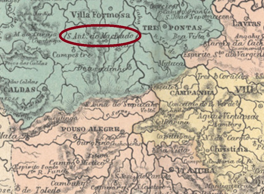
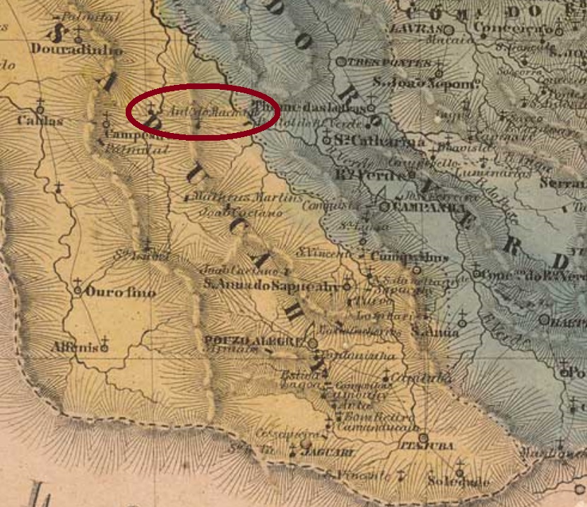
The district of Santo Antonio do Machado was created in July 1857 in the municipality of Alfenas, situated on the west bank of the Machado River, over 400 km southwest of the provincial capital Ouro Preto. The name derivates supposedly from an old farmer family of the region. The locality obtained the political autonomy as a villa in November 1880 and was elevated to a town in September 1923, under the simplified name of Machado.
Both Nova Monteiro (Administrações e Agencias Postaes do Brasil Imperio, in Brasil Filatelico/RJ, 1934-5; Reprint SPP 1994-1999) and Paul Sobrinho (História Postal de Minas Gerais, Belo Horizonte, 1997) state that the local post office was created in July 1864.
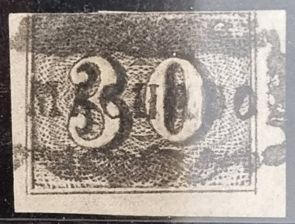
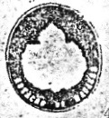
The oldest postmark is MMG-3830a (Fig. Marcio Duarte), which also exists in brown and dark purple:
MMG-3830a (MDu) 1864-1876ff
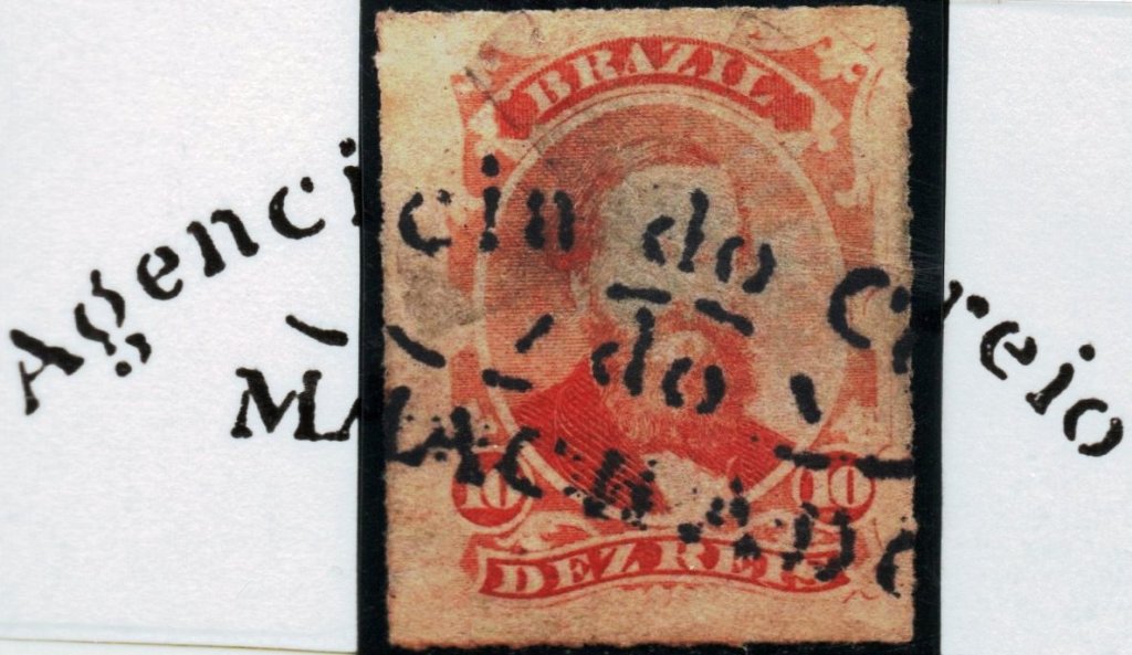
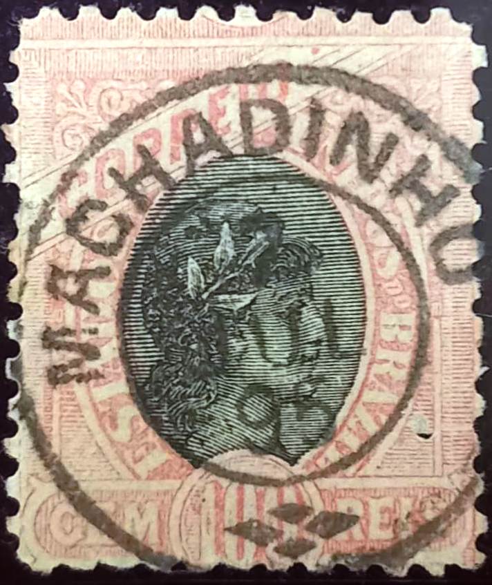
This was followed by MMG-3830b, which was given the number 1150 by P. Ayres (Catálogo de Carimbos Brasil-Império, S. Paulo, 1937, 1942), shown here in an example from the José A. Junges collection:
MMG-3830b (P.A. 1150 – JJ) 1876ff
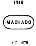
P. Ayres (op. cit.) also showed, under no. 1346, a postmark that has not yet been confirmed:
P.A. 1346
For cancels with Santo Antonio do Machado see SMG-3035.
Villiers de l’Ile Adam: Carta (…) da Provincia de Minas Geraes, 1849
Siehe auch Santo Antonio do Machado (SMG-3035)
Der Distrikt von Santo Antonio do Machado wurde im Juli 1857 im Município von Alfenas gegründet und lag am Westufer des Flusses Machado, über 400 km südwestlich der Provinzhauptstadt Ouro Preto. Der Name stammt vermutlich aus einem alten Stammesgeschlecht von Großgrundbesitzern der Region. Die Ortschaft erhielt die politische Selbständigkeit als eine Villa im November 1880 und stieg – unter dem vereinfachten Namen Machado – zu einer Stadt im September 1923 auf.
Sowohl Nova Monteiro (Administrações e Agencias Postaes do Brasil Imperio, in Brasil Filatelico/RJ, 1934-5; Reprint SPP 1994-1999) als auch Paul Sobrinho (História Postal de Minas Gerais, Belo Horizonte, 1997) sind sich darüber einig, dass das örtliche Postamt im Juli 1864 entstanden ist. Der älteste Poststempel ist MMG-3830a (Abb. Marcio Duarte), den es auch in Braun und Dunkelviolett gibt:
MMG-3830a (MDu) 1864-1876ff
Es folgte MMG-3830b, der von P. Ayres (Catálogo de Carimbos Brasil-Império, S. Paulo, 1937, 1942), die Nr. 1150 erhielt, hier in einem Beispiel aus der Sammlung José A. Junges:
MMG-3830b (P.A. 1150 – JJ) 1876ff
P. Ayres (op. cit.) zeigte auch unter Nr. 1346 einen Poststempel, der bisher nicht bestätigt werden konnte:
P.A. 1346
Für Poststempel mit Santo Antonio do Machado siehe SMG-3035.
Since September 1870, Machadinho had been a district of Vila de Sto. Antonio do Machado, located 430 km southwest of the provincial capital Ouro Preto. A year later, it was elevated to the Freguesia de São Francisco de Paula do Machadinho, then this Freguesia was assigned to Vila de Alfenas a year later and returned to Machado in November 1880. In September 1923, the place became the Município de Gimirim and two years later a city, which has been called Poço Fundo since December 1953.
Paula Sobrinho (História Postal de Minas Gerais, Belo Horizonte, 1997) and R. Koester (Carimbologia XXVII) agree that there has been a post office there since January 1880. The oldest postmark to date is MMG-1525a (Fig. José L. Fevereiro):
MMG-1525a (JLF) 1884-1899Google Maps
Andere Namen: Gimirim, Poço Fundo (1953)
Machadinho war seit September 1870 ein Distrikt der Vila de Sto. Antonio do Machado, das 430 km südwestlich der Provinzhauptstadt Ouro Preto lag. Ein Jahr später wurde er zur Freguesia de São Francisco de Paula do Machadinho erhoben, dann wechselte diese Freguesia ein Jahr später zur Vila de Alfenas und kehrte im November 1880 zu Machado zurück. Im September 1923 wurde der Ort zum Município de Gimirim und zwei Jahre später zur Stadt, die seit Dezember 1953 Poço Fundo heißt.
Paula Sobrinho (História Postal de Minas Gerais, Belo Horizonte, 1997) und R. Koester (Carimbologia XXVII) sind sich einig, dass es dort seit Januar 1880 ein Postamt gab. Der bisher älteste Poststempel ist MMG-1525a (Abb. José L. Fevereiro):
Villiers de l’Ile Adam: Carta (…) da Provincia da Bahia, 1848
Text update on June 30, 2025
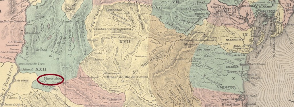
Macaúbas was declared a village in July 1832. It was located on the eastern bank of the Riacho do Peixe, 620 kilometres west of the provincial capital Salvador da Bahia. In May 1840, it became the parish of Nossa Senhora da Conceição de Macaúbas and in June 1925, it became a town.
Two different dates have been found for the establishment of the local post office. One is March 1836, as Nova Monteiro writes in Administrações e Agencias Postaes do Brasil Imperio (Brasil Filatelico/RJ, 1934–1935; reprinted by SPP 1994–1999). The second date is 1861, as stated in the directory of imperial post offices (Tabella das Agencias do Correio do Imperio, Rio de Janeiro, 1885).
The oldest imperial postmark to date is MBA-0795a (Fig. Felipe Piccinini):
MBA-0795a (FP) 1847
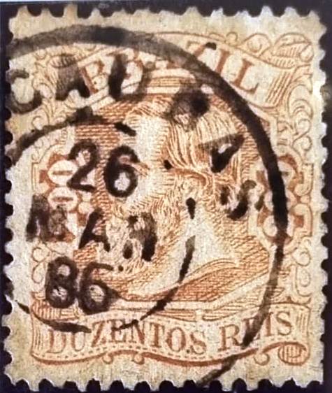
MBA-0795b (Marcio Duarte Collection) did not appear until the 1880s:
MBA-0795b (MD) 1885-1886Atlas do Imperio do Brasil, 1868
Textaktualisierung am 30. Juni 2025
Macaúbas wurde im Juli 1832 zur Vila erklärt. Sie lag am Ostufer des Riacho do Peixe, 620 Kilometer westlich der Provinzhauptstadt Salvador da Bahia. Im Mai 1840 wurde sie zur Freguesia de Nossa Senhora da Conceição de Macaúbas und im Juni 1925 zur Stadt.
Es wurden zwei verschiedene Daten für die Einrichtung des örtlichen Postamts gefunden. Zum einen im März 1836, wie Nova Monteiro in Administrações e Agencias Postaes do Brasil Imperio (Brasil Filatelico/RJ, 1934–1935; Nachdruck SPP 1994–1999) schreibt. Ein zweites Mal im Jahr 1861, wie aus dem Verzeichnis der kaiserlichen Postämter (Tabella das Agencias do Correio do Imperio, Rio de Janeiro, 1885) hervorgeht.
Der bisher älteste kaiserliche Poststempel ist MBA-0795a (Abb. Felipe Piccinini):
MBA-0795a (FP) 1847
Erst in den 1880er Jahren erschien MBA-0795b (Samml. Marcio Duarte):
Villiers de l’Ile Adam: Carta (…) das Provincias do Rio Grande do Norte e Parahiba, 1850
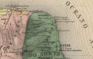
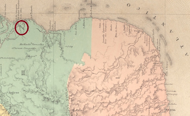
This locality, located at the mouth of the Piranhas River (now the Açu River), 180 kilometres northwest of the provincial capital Natal, became a village in October 1847 and later, in August 1854, the parish of Nossa Senhora da Conceição de Macau. Since October 1875, Macau has been a town. The name is of Chinese origin and was given by Portuguese settlers in honour of the Asian colony of the same name. Originally, the place was called Ama-ngao, which means ‘port of the goddess of sailors.
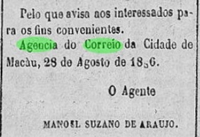
Three dates of creation were found for the local post office. It was first mentioned with creation year 1836 in the directory of imperial post offices (Tabella das Agencias do Correio do Imperio, Rio de Janeiro, 1885), then in October 1837, as Nova Monteiro writes in Administrações e Agencias Postaes do Brasil Imperio (Brasil Filatelico/RJ, 1934–1935; reprinted by SPP 1994–1999), and finally in October 1886, as noted by R. Koester in Carimbologia XXVII. However, the latter date must be incorrect, as the agency was still in operation in August of that year, according to the local press.
O Macauense, 07/09/1886
The oldest postal cancellation to date is handwritten and was shown by Denis Forte:
1850ff (DF)
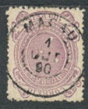
The oldest postmark to date is MRN-0105b (fig. Koester, op. cit.):
MRN-0105b (RK) 1878ff
In the 1880s, MRN-0105c (fig. from the Internet) also appeared:
MRN-0105c (Philasearch) 1885-1899Atlas do Imperio do Brasil, 1868
Diese Ortschaft an der Mündung des Piranhas (heute Rio Açu), die 180 Kilometer nordwestlich der Provinzhauptstadt Natal lag, wurde im Oktober 1847 zur Vila und erst später, im August 1854, zur Freguesia de Nossa Senhora da Conceição de Macau. Seit Oktober 1875 ist Macau eine Stadt. Der Name hat einen chinesischen Ursprung und soll von portugiesischen Siedlern nach der gleichnamigen Kolonie benannt worden sein. Ursprünglich hieß der Ort Ama-ngao, was „Hafen der Göttin der Seefahrer” bedeutet.
Es wurden drei Entstehungsdaten für das örtliche Postamt gefunden. Es wurde erstmals mit Datum 1836 im Verzeichnis der kaiserlichen Postämter (Tabella das Agencias do Correio do Imperio, Rio de Janeiro, 1885) aufgeführt, dann im Oktober 1837, wie Nova Monteiro in Administrações e Agencias Postaes do Brasil Imperio (Brasil Filatelico/RJ, 1934–1935; Nachdruck SPP 1994–1999) schreibt, und zuletzt im Oktober 1886, wie R. Koester in Carimbologia XXVII vermerkt. Das letzte Datum dürfte jedoch inkorrekt sein, da die Agentur im August desselben Jahres noch in Betrieb war, wie aus der lokalen Presse hervorgeht.
O Macauense, 07/09/1886
Die bisher älteste postalische Entwertung ist handschriftlich und wurde von Denis Forte gezeigt:
1850ff (DF)
Der älteste Poststempel ist bisher MRN-0105b (Abb. Koester, op. cit.):
MRN-0105b (RK) 1878ff
In den 1880er Jahren erschien auch MRN-0105c (Abb. aus dem Internet):
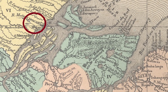
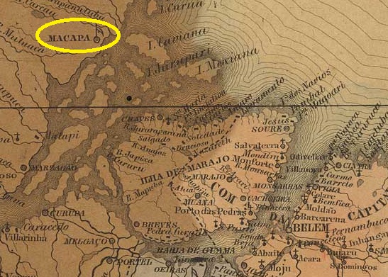
The history of the settlement began in 1740 with the construction of the Sto. Antonio fortress. By 1752, a povoação had already been established there, 530 kilometres northwest of the provincial capital Belém do Pará. In February 1758, it was named Vila de S. José de Macapá. Macapá has been a town since September 1856 and the capital of the Amapá Territory since September 1943. This remained the case when Amapá became a federal state in 1988.
As Nova Monteiro wrote in Administrações e Agencias Postaes do Brasil Imperio (Brasil Filatelico/RJ, 1934–1935; reprinted by SPP 1994–1999), there had been a post office there since March 1829. The oldest postmark to date is MPA-0145a, which is reproduced in the RHM catalogue.
MPA-0145a (RHM) 1843 ff
This was taken out of service shortly afterwards, as stamps were cancelled by hand in the 1850s, as shown in the illustration by Carlos A. Balata.
1856 (CB)
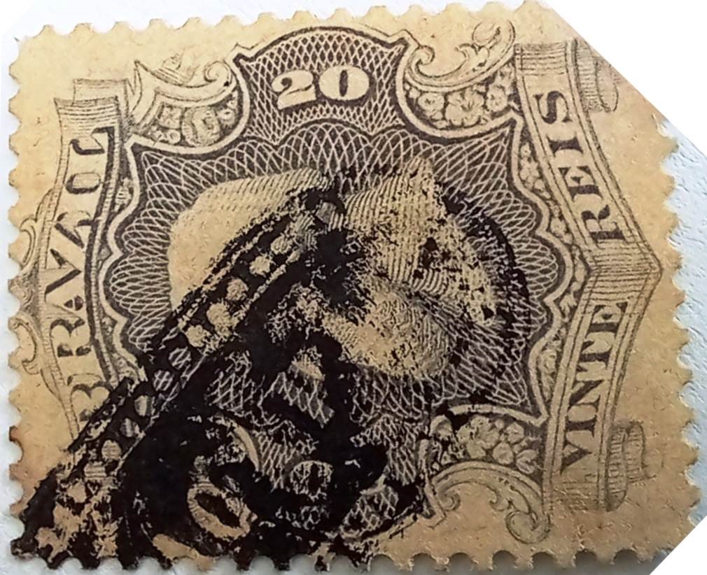
This was later followed by the postmark MPA-0145b (Fuad Ferreira Fo. collection) in the form typical for the province of Pará.
MPA-0145b (FF) 1866 ff
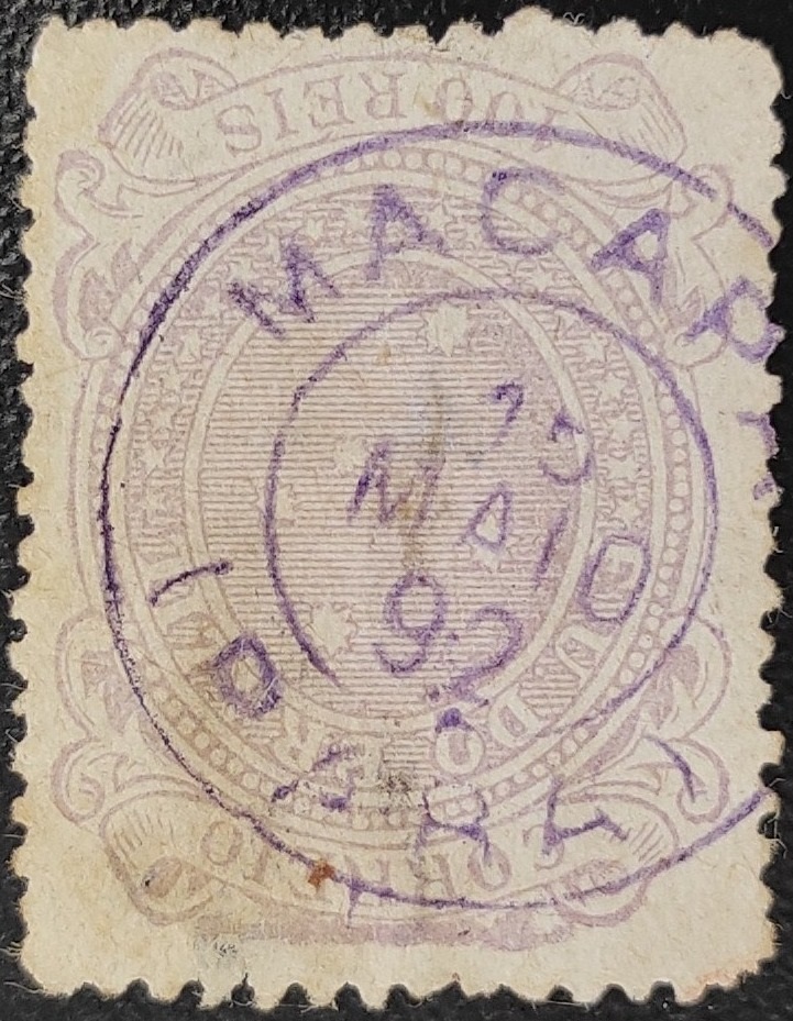
Towards the end of the Empire, MPA-0145c also appeared (illustration from the Internet):
MPA-0145c (EB) 1889-1892Villiers de l’Ile Adam: Carta (…) das Provincias do Grão-Pará e Alto Amazonas, 1850
Die Geschichte der Siedlung begann im Jahr 1740 mit dem Bau der Festung Sto. Antonio an. Bereits 1752 war vor Ort eine Povoação entstanden, die 530 Kilometer nordwestlich der Provinzhauptstadt Belém do Pará lag. Im Februar 1758 wurde sie zur Vila de S. José de Macapá ernannt. Seit September 1856 ist Macapá eine Stadt und seit September 1943 die Hauptstadt des Amapá-Territoriums. Dies blieb auch so, als Amapá 1988 zum Bundesstaat wurde.
Wie Nova Monteiro in Administrações e Agencias Postaes do Brasil Imperio (Brasil Filatelico/RJ, 1934–1935; Nachdruck SPP 1994–1999) schrieb, gab es dort seit März 1829 ein Postamt. Der bisher älteste Poststempel ist MPA-0145a, der im RHM-Katalog abgebildet ist.
MPA-0145a (RHM) 1843 ff
Dieser wurde kurz darauf außer Betrieb genommen, da in den 1850er Jahren Briefmarken per Hand entwertet wurden, wie die Abbildung von Carlos A. Balata zeigt.
1856 (CB)
Später folgte der Poststempel MPA-0145b (Sammlung Fuad Ferreira Fo.) in der für die Provinz Pará typischen Form.
MPA-0145b (FF) 1866ff
Gegen Ende des Kaiserreichs erschien auch MPA-0145c (Abb. aus dem Internet):
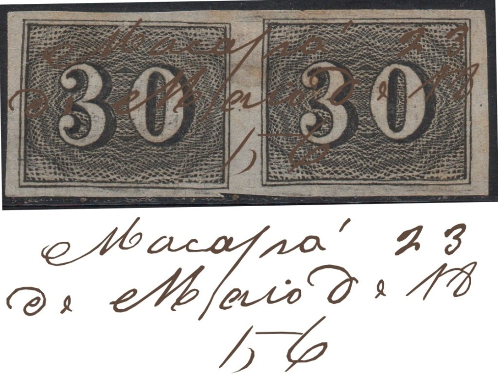
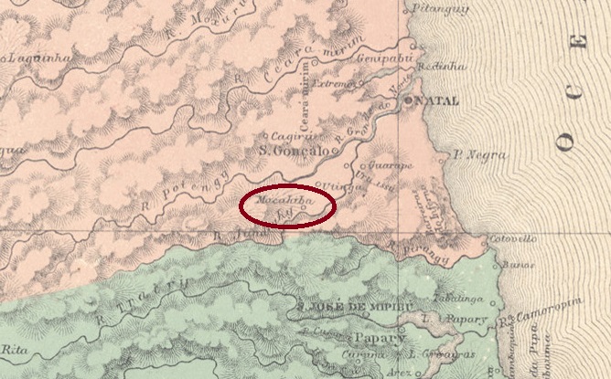
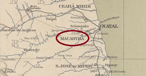
Since October 1877, Macahyba had been a village located on the north bank of the Riacho de Sangue. At that time, the river was still called Jundiahy, and Macahyba was located 25 km southwest of the provincial capital Natal. Two months later, the Freguesia de Nossa Senhora da Conceição de Macahyba was established. Since January 1889, Macaíba (as it is spelled today) has been a city.
R. Koester writes in Carimbologia XXVII that there had been a post office there since September 1870. The only imperial postmark to date is MRN-0100a (Fig. Koester, op. cit.):
MRN-0100a (RK) 1888Serviço Geologico e Mineralogico, 1910
Seit Oktober 1877 war Macahyba eine Vila, die am Nordufer des Riacho de Sangue lag. Der Fluss hieß damals noch Jundiahy und Macahyba befand sich 25 km südwestlich der Provinzhauptstadt Natal. Zwei Monate später wurde die Freguesia de Nossa Senhora da Conceição de Macahyba errichtet. Seit Januar 1889 ist Macaíba (wie es heute geschrieben wird) eine Stadt.
R. Koester schreibt in Carimbologia XXVII, dass es dort seit September 1870 ein Postamt gab. Der bisher einzige kaiserliche Poststempel ist MRN-0100a (Abb. Koester, op. cit.):
Colton & Colton: Provincia do Rio de Janeiro, 1866
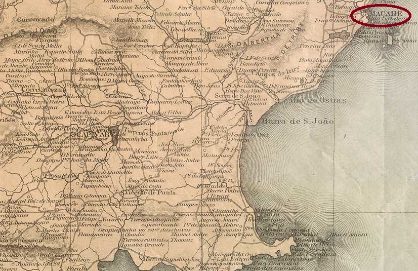
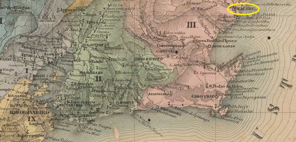
From around 1620, this was an Indian village of the Goitacazes tribe at the mouth of the Macaé river in the Vila de Cabo Frio area, 190 kilometres north-east of the capital Rio de Janeiro. In July 1813 it became a Vila, in May 1815 the Freguesia de São João Baptista de Macaé and in April 1846 finally the city of Macaé, as it is written today.
Nova Monteiro writes in Administrações e Agencias Postaes do Brasil Imperio (Brasil Filatelico/RJ, 1934-1935; reprint SPP 1994-1999) that there had been a post office there since November 1824. In Carimbologia XXVII, R. Koester shows a handwritten postal cancellation from the year 1829.
1829 (RK)
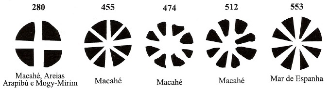
The oldest postmark to date is MRJ-0695a, which bears the number P-RJ-14 in the RHM catalogue:
MRJ-0695a (RHM P-RJ-14) 1835-1843ff
This was followed by MRJ-0695b , whose RHM illustration was corrected by Henrique B. Ferreira (Catálogo ilustrado dos carimbos sobre os olhos-de-boi, 4a. ed, Porto Alegre, 2017):
MRJ-0695b (RHM recte HBF) 1843ff
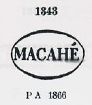
Then came MRJ-0695c, which also exists in red and blue and was given the no. 1343 by P. Ayres (Catálogo de Carimbos Brasil-Império, S. Paulo, 1937, 1942):
MRJ-0695c (P.A. 1343) 1844ff-1871
The following MRJ-0695d can also be seen in P. Ayres:
MRJ-0695d (P.A. p. 122) 1878-1886
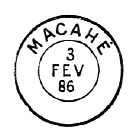
Towards the end of the century, the postmark MRJ-0695e (fig. Luiz C. Fritzen) proudly showed the city status of Macaé
MRJ-0695e (LCF) 1887-1899
James Dingler and Klerman W. Lopes have shown five mute cancellations from Macaé in Mute Cancellations of the Brazil Empire / Carimbos Mudos do Brasil Império (Brazil Philatelic Association, Rio de Janeiro, 2000):
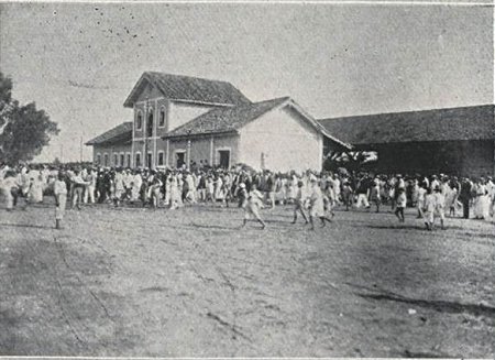
Macaé station was opened in June 1873 by the railway company E.F. Macaé e Campos (coastal line) on the edge of the then urban area. In 1890, the railway line was transferred to E.F. Leopoldina and belonged to Rede Ferroviária Federal S.A. (estacoesferroviarias.com.br) from 1975 until the line was closed in 1996. The tracks are still there today. The station building is used as an office for the railway company.
In 1923 (O Malho, 02 June 1923, on estacoesferroviarias.com.br)In July 2022 (Photo: Google Maps)
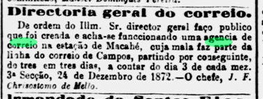
According to the regional press, there has been a post office at the station since December 1872:
Jornal do Commercio, 25/12/1872
The only imperial postmark here to date is MRJ-2390a (image from the Internet):
MRJ-2390a (EB) 1880ffVilliers de l’Ile Adam: Carta (…) da Provincia do Rio de Janeiro, 1850
Seit ca. 1620 war dies ein Indianerdorf des Stammes der Goitacazes an der Mündung des Macaé im Gebiet der Vila de Cabo Frio, 190 km nordöstlich der Hauptstadt Rio de Janeiro. Im Juli 1813 wurde es zur Vila, im Mai 1815 zur Freguesia de São João Baptista de Macaé und im April 1846 schließlich zur Stadt Macaé, wie sie heute geschrieben wird.
Nova Monteiro schreibt in Administrações e Agencias Postaes do Brasil Imperio (Brasil Filatelico/RJ, 1934–1935; Nachdruck SPP 1994–1999), dass es dort seit November 1824 ein Postamt gab. R. Koester zeigt in Carimbologia XXVII einen handschriftlichen Postvermerk aus dem Jahr 1829.
1829 (RK)
Der bisher älteste Poststempel ist MRJ-0695a, der im RHM-Katalog die Nr. P-RJ-14 trägt:
MRJ-0695a (RHM P-RJ-14) 1835-1843ff
Es folgte MRJ-0695b , dessen RHM-Abbildung durch Henrique B. Ferreira (Catálogo ilustrado dos carimbos sobre os olhos-de-boi, 4a. ed, Porto Alegre, 2017) korrigiert wurde:
MRJ-0695b (RHM recte HBF) 1843ff
Danach kam MRJ-0695c, den es auch in Rot und Blau gibt und der von P. Ayres (Catálogo de Carimbos Brasil-Império, S. Paulo, 1937, 1942) die Nr. 1343 erhielt:
MRJ-0695c (P.A. 1343) 1844ff-1871
Auch im P. Ayres ist der folgende MRJ-0695d zu sehen:
MRJ-0695d (P.A. S. 122) 1878-1886
Gegen Ende des Jahrhunderts zeigte der Poststempel MRJ-0695e (Abb. Luiz C. Fritzen) stolz den Stadtstatus von Macaé:
MRJ-0695e (LCF) 1887-1899
James Dingler und Klerman W. Lopes haben in Mute Cancellations of the Brazil Empire / Carimbos Mudos do Brasil Império (Brazil Philatelic Association, Rio de Janeiro, 2000) fünf stumme Abstempelungen aus Macaé gezeigt :
Der Bahnhof Macaé wurde im Juni 1873 von der Eisenbahngesellschaft E.F. Macaé e Campos (Küstenlinie) am Rande des damaligen Stadtgebiets eröffnet. 1890 ging die Bahnlinie an die E.F. Leopoldina über und gehörte von 1975 bis zur Streckenstilllegung im Jahr 1996 zur Rede Ferroviária Federal S.A. (estacoesferroviarias.com.br). Heute sind die Gleise noch vorhanden. Das Bahnhofsgebäude wird als Büro der Bahngesellschaft genutzt.
Im Jahr 1923 (Abb.: O Malho, 02.06.1923, auf estacoesferroviarias.com.br)Im Juli 2022 (Google Maps)
Wie die regionale Presse mitteilte, gab es am Bahnhof ein Postamt seit Dezember 1872:
Jornal do Commercio, 25.12.1872
Der bisher einzige kaiserliche Poststempel hier ist MRJ-2390a (Abb. aus dem Internet):
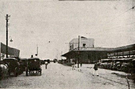
The central station of the Estrada de Ferro Macahe e Campos railway company was opened in July 1875. It was not located in today’s Macaé, but in the urban area of Campos dos Goytacazes, which is 280 kilometres north-east of the capital Rio de Janeiro. The railway line became the property of E. F. Leopoldina in 1887 and belonged to Rede Ferroviária Federal S. A. (estacoesferroviarias.com.br) from 1975 until it was shut down in 1996. Today, the tracks are still in place and the building is used as a railway museum.
In June 1918 (Fon-Fon, 08/06/1918, on estacoesferroviarias.com.br)
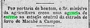
In February 1881, it was decided to build the railway post office, as reported in the regional press.
Gazeta de Noticias, 19/02/1881
Paulo Novaes writes on agenciaspostais.com.br that the post office was closed around 1900. However, as it is not listed in the directory of imperial post offices (Tabella das Agencias do Correio do Imperio, Rio de Janeiro, 1885), it must have been out of service in the meantime.
R. Koester shows two postmarks in Carimbologia XXVII that probably belong here, but the image quality is poor.
Der Zentralbahnhof der Eisenbahngesellschaft Estrada de Ferro Macahe e Campos wurde im Juli 1875 eröffnet. Er lag nicht im heutigen Macaé, sondern im Stadtgebiet von Campos dos Goytacazes, 280 Kilometer nordöstlich der Hauptstadt Rio de Janeiro. Die Bahnlinie ging 1887 in den Besitz der E. F. Leopoldina über und gehörte von 1975 bis zur Stilllegung im Jahr 1996 zur Rede Ferroviária Federal S. A. (estacoesferroviarias.com.br). Heute sind die Gleise noch vorhanden und das Gebäude wird als Eisenbahnmuseum genutzt.
Im Juni 1918 (Fon-Fon, 08.06.1918, auf estacoesferroviarias.com.br)
Im Februar 1881 wurde beschlossen, das Bahnhofspostamt zu errichten, wie aus der regionalen Presse hervorgeht.
Gazeta de Noticias, 19.02.1881
Paulo Novaes schreibt auf agenciaspostais.com.br, dass das Postamt um 1900 geschlossen wurde. Da es jedoch nicht im Verzeichnis der kaiserlichen Postämter (Tabella das Agencias do Correio do Imperio, Rio de Janeiro, 1885) aufgeführt ist, muss es zwischendurch außer Betrieb gewesen sein.
R. Koester zeigt in Carimbologia XXVII zwei Poststempel, die wahrscheinlich hierhergehören, allerdings ist die Bildqualität schlecht.
Colton & Colton: Provincia do Rio de Janeiro, 1866
Other names: Tairetá, Paracamby (1903)
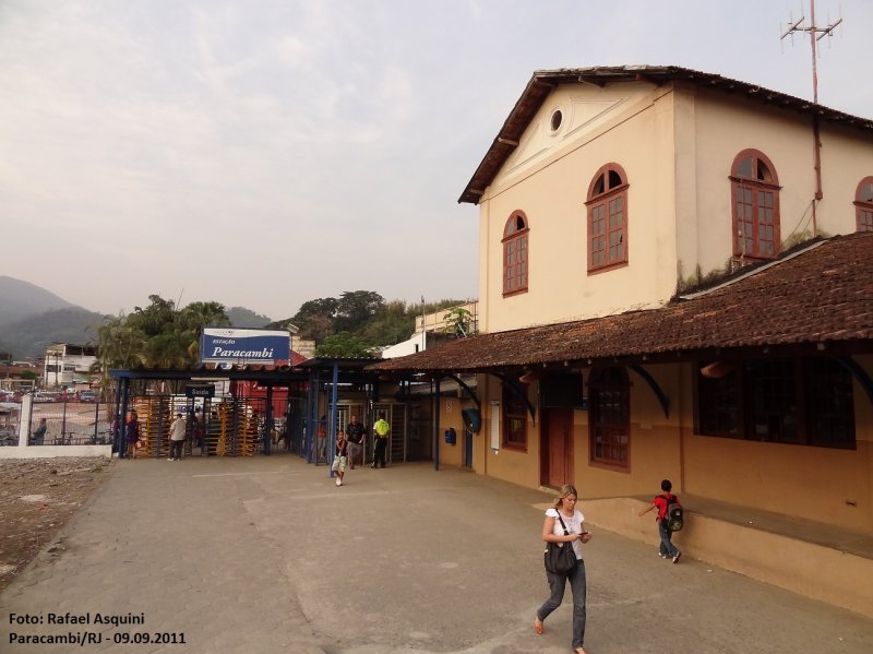
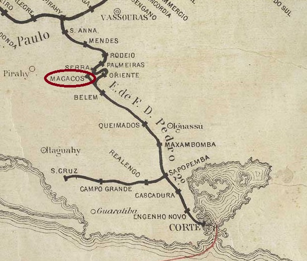
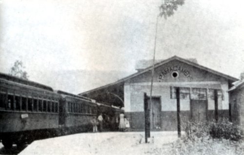
The Macacos (Monkeys) railway station was opened in August 1861 by the E. F. D. Pedro II railway company (Macacos branch) on the east bank of the Macacos stream, now called Ribeirão das Lajes, in the Município de Vassouras, 85 km north-west of the capital Rio de Janeiro. The railway line changed to the E. F. Central do Brasil in 1889, Rede Ferroviária Federal S. A. in 1975 and has been operated by the Supervia consortium since 1997. The branch was probably built for the Fazenda dos Macacos, where the Brasil Industrial textile factory was later located, which despite its name was owned by the British (estacoesferroviarias.com.br).
Around 1930 (Photo: NN, on estacoesferroviarias.com.br)In September 2011 (Photo: Rafael Asquini, on estacoesferroviarias.com.br)
As the name ‘Macacos’ was not very popular, the town and railway station changed their names several times in the following years. In June 1892, Macacos became part of the district of Belém, in August 1903 the station was called Paracamby, in September 1906 Macacos became a district, which later changed its name four times: In September 1909 it was called Belém, in November 1919 Paracamby again, in December 1938 Tairetá and finally in August 1960 Paracambi again, now as an independent Município.
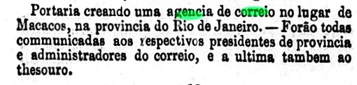
As noted in the minutes of the imperial ministry, the creation of a local post office was decided in October 1861.
Expediente do Ministerio do Imperio, 14 October 1861
Paulo Novaes writes on agenciaspostais.com.br that the agency was renamed Paracamby in November 1903.
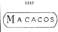
Paulo Ayres shows in Catálogo de Carimbos Brasil-Império (São Paulo, 1937, 1942) a postmark with the number 1341, which unfortunately has not yet been confirmed anywhere.
P.A. 1341
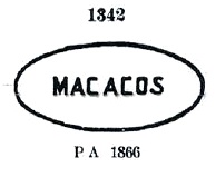
The following postmark no. 1342 shown by him, however, could be confirmed beyond doubt:
MRJ-1800a (P.A. 1342) 1866ff
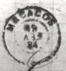
This was followed by the simple double circle MRJ-1800b (fig. R. Koester, in Carimbologia XXVII):
MRJ-1800b (RK) 1884
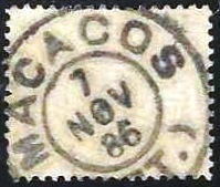
Then came MRJ-1800c (ill. Luiz C. Fritzen):
MRJ-1800c (LCF) 1886-1897
Koester (op. cit.) also showed the postmark with the imperial seal MRJ-1800d:
MRJ-1800d (RK)
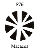
From Macacos station also comes the mute cancellation BPA 576, as noted by James Dingler and Klerman W. Lopes in Mute Cancellations of the Brazil Empire / Carimbos Mudos do Brasil Império (Brazil Philatelic Association, Rio de Janeiro, 2000):
BPA 576 (1884-1887ff)Estações (…) de São Paulo, Rio de Janeiro e Minas, 1880
Andere Namen: Tairetá, Paracamby (1903)
Der Bahnhof Macacos (Affen) wurde im August 1861 von der Eisenbahngesellschaft E. F. D. Pedro II. (Macacos-Zweig) am Ostufer des Macacos-Bachs, der heute Ribeirão das Lajes heißt, im Município de Vassouras, 85 km nordwestlich der Hauptstadt Rio de Janeiro, eröffnet. Die Bahnlinie wechselte 1889 zur E. F. Central do Brasil, 1975 zur Rede Ferroviária Federal S. A. und wird seit 1997 vom Supervia-Konsortium betrieben. Vermutlich wurde die Abzweigung für die Fazenda dos Macacos gebaut, auf der sich später die Textilfabrik Brasil Industrial befand, die trotz ihres Namens im englischen Besitz war (estacoesferroviarias.com.br).
Ca. 1930 (Foto: NN, auf estacoesferroviarias.com.br)Im September 2011 (Foto: Rafael Asquini, auf estacoesferroviarias.com.br)
Da der Name „Macacos” wenig Zuspruch fand, wechselten Ort und Bahnhof in der folgenden Zeit mehrmals ihre Bezeichnung. Im Juni 1892 wurde Macacos Teil des Distrikts Belém, im August 1903 hieß der Bahnhof Paracamby, im September 1906 wurde Macacos zum Distrikt, der später seinen Namen viermal änderte: Im September 1909 hieß er Belém, im November 1919 wieder Paracamby, im Dezember 1938 Tairetá und schließlich im August 1960 erneut Paracambi, nun als eigenständiger Município.
Wie im Protokoll des kaiserlichen Ministeriums vermerkt, wurde im Oktober 1861 die Einrichtung eines Bahnhofspostamts beschlossen.
Expediente do Ministerio do Imperio, 14.10.1861
Paulo Novaes schreibt auf agenciaspostais.com.br, dass die Agentur im November 1903 in Paracamby umbenannt wurde.
Paulo Ayres zeigt in Catálogo de Carimbos Brasil-Império (São Paulo, 1937, 1942) einen Poststempel mit der Nummer 1341, der bisher leider nirgends bestätigt werden konnte.
P.A. 1341
Der folgende von ihm gezeigte Poststempel Nr. 1342 konnte hingegen zweifelsfrei bestätigt werden:
MRJ-1800a (P.A. 1342) 1866ff
Es folgte der schlichte Doppelkreis MRJ-1800b (Abb. R. Koester, in Carimbologia XXVII):
MRJ-1800b (RK) 1884
Danach kam MRJ-1800c (Abb. Luiz C. Fritzen):
MRJ-1800c (LCF) 1886-1897
Koester (op. cit.) zeigte auch den Poststempel mit dem kaiserlichen Siegel MRJ-1800d:
MRJ-1800d (RK)
Vom Bahnhof Macacos kommt auch der stumme Stempel BPA 576, wie von James Dingler und Klerman W. Lopes in Mute Cancellations of the Brazil Empire / Carimbos Mudos do Brasil Império (Brazil Philatelic Association, Rio de Janeiro, 2000) vermerkt: