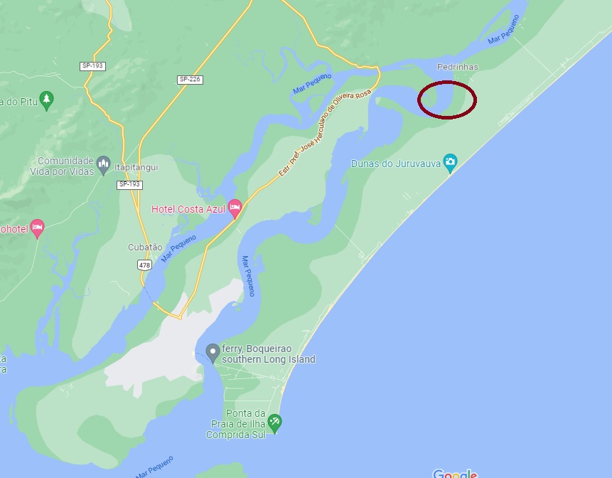
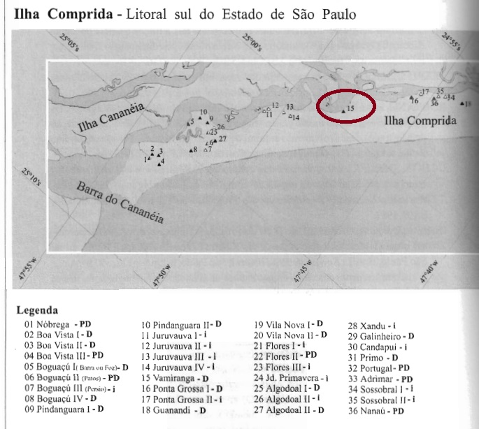
Vamiranga is another village that has since disappeared from the map. We don’t even know where it was exactly. It is certain that in the 19th century Vamiranga was a rural suburb on Comprida (=Long) Island, which at that time belonged to the município of Cananea, located about 240 km southwest of the provincial capital São Paulo. Ilha Comprida has been an independent município since December 1991, presumably the present seaside resort of Pedrinhas is the successor settlement for Vamiranga. The word from the Indian language is said to mean red fruit.
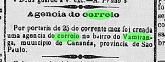
The local post office was created in July 1888, as reported in the Rio press:
Jornal do Commercio/RJ, 27.07.1888
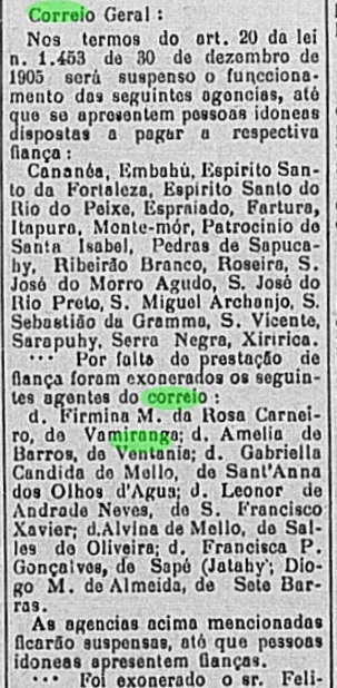
At the beginning of 1907, the postal agent in charge was dismissed because serious accounting problems had not been solved, and the post office had to close, apparently for good:
Correio Paulistano, 09.02.1907
So far no imperial postmark has been seen from this locality. It must be very rare.
Uchoa: Sambaquis da Ilha Comprida
Vamiranga ist eine weitere Ortschaft, die inzwischen aus der Karte verschwunden ist. Wir wissen nicht mal, wo sie genau lag. Sicher ist, dass Vamiranga im 19. Jahrhundert ein ländlicher Vorort auf der Comprida (=Lange)-Insel war, die damals dem Município von Cananea angehörte, ungefähr 240 km südwestlich der Provinzhauptstadt São Paulo gelegen. Ilha Comprida ist seit Dezember 1991 ein eigenständiger Município, vermutlich ist der heutige Badeort Pedrinhas die Nachfolgesiedlung für Vamiranga. Das Wort aus der Indianersprache soll Rote Frucht bedeuten.
Das örtliche Postamt entstand im Juli1888, wie die Presse aus Rio bekannt machte:
Jornal do Commercio/RJ, 27.07.1888
Am Anfang 1907 wurde der zuständige Postagent entlassen, da gravierende Abrechnungsprobleme nicht gelöst waren, und das Postamt musste schließen, offenbar für immer:
Correio Paulistano, 09.02.1907
Bisher wurde kein kaiserlicher Poststempel aus dieser Ortschaft gesehen. Er muss sehr selten sein.
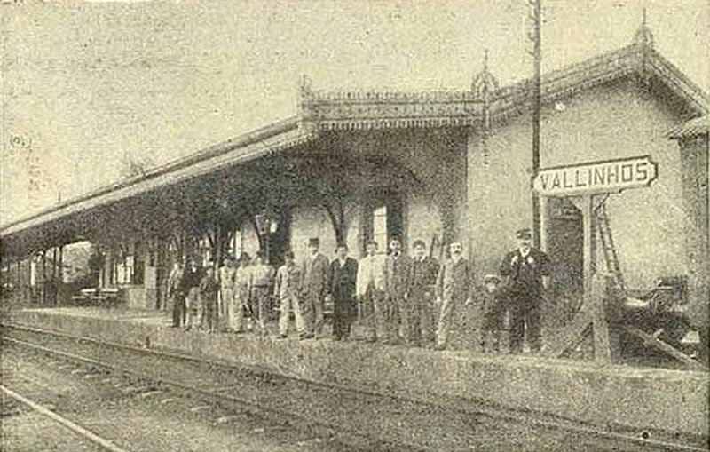
Vallinhos station was inaugurated by the Cia. Paulista railway company (main line) in March 1872 and was in the Município of Campinas, 90 km northwest of the provincial capital São Paulo. In 1913, a new station was built, which was in operation until the line was closed in 1998. The old station was nevertheless not demolished and is still said to serve as a residential building today. From 1971, the railway line belonged to FEPASA (estacoesferroviarias.com.br).
In 1908 (Photo: O Malho in estacoesferroviarias.com.br)
Around the station, the settlement continued to grow and was elevated to the district of Campinas in May 1896. Since December 1953, Valinhos (as it is written today) has been an independent municipio.
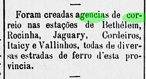
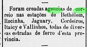
The station post office was created in December 1879, according to the regional press:
A Constituinte, 25/12/1879
The imperial postmark of this is the French type VSP-2030a (Coll. José A. Junges): a double circle with the inscription EST. DE VALLINHOS at the top and the star between brackets at the bottom. The dates in the middle have been found so far for the period 1888 and 1891ff.
Arthur D. Ribeiro: Estado de São Paulo, 1924
Der Bahnhof Vallinhos wurde durch die Cia. Paulista Bahngesellschaft (Hauptlinie) im März 1872 eingeweiht und lag im Município von Campinas, 90 km nordwestlich der Provinzhauptstadt São Paulo entfernt. 1913 wurde ein neuer Bahnhof gebaut, der bis zur Streckenstilllegung 1998 in Betrieb war. Der alte Bahnhof wurde dennoch nicht abgerissen und soll heute noch als Wohngebäude dienen. Ab 1971 gehörte die Bahnlinie der FEPASA (estacoesferroviarias.com.br).
1908 (Foto: O Malho, in estacoesferroviarias.com.br)
Rund um den Bahnhof wuchs die Siedlung weiter und wurde Mai 1896 zum Distrikt von Campinas erhoben. Seit Dezember 1953 ist Valinhos (wie es heute geschrieben wird) ein eigenständiger Municipio.
Das Bahnhofspostamt wurde im Dezember 1879 ins Leben gerufen, wie die Regionalpresse mitteilte:
A Constituinte, 25.12.1879
Der kaiserliche Poststempel davon ist der französischer Typus VSP-2030a (Samml. José A. Junges): ein Doppelkreis mit der Inschrift EST. DE VALLINHOS oben und dem Stern zwischen Klammern unten. Die Daten in der Mitte wurden bisher für den Zeitraum 1888 und 1891ff gefunden.
See also Conceição da Ponte Nova (Koester: Carimbologia XIII).
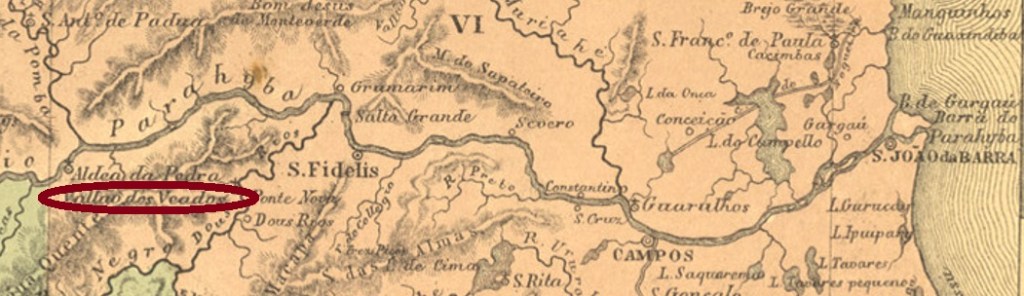
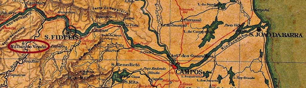
In addition to the Tapir Rift, there was also the Deer Rift (Vallão dos Veados) in the Imperial Province of Rio de Janeiro. This parish was named S. João Baptista do Vallão dos Veados in October 1857 and was located on the stream of the same name in the Município of São Fidélis, 270 km northeast of the capital Rio de Janeiro. Afterwards, the place name changed twice: in October 1890 to Dois Rios and in December 1938 to the district of Colônia, which is still valid today.
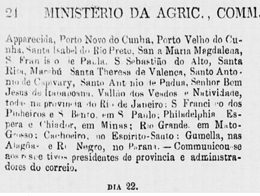
According to Nova Monteiro (Administrações e Agencias Postaes do Brasil Imperio, in Brasil Filatelico/RJ, 1934-5; Reprint SPP 1994-1999), the local post office came into being in July 1855. It had a short period of operation, as only six years later its closure was announced:
Expediente do Ministerio do Imperio, 21.06.1861
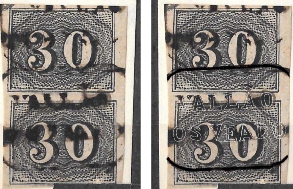
The postmark VRJ-0985a (RHM) is therefore rarely seen:
VRJ-0985a (RHM) 1855-1861
The post office reopened in 1873 in the neighbouring town of Conceição da Ponte Nova. For these postmarks see R. Koester: Carimbologia XIII.
Almanak Laemmert, 1892
Andere Namen: Dois Rios, Colonia
Siehe auch Conceição da Ponte Nova (Koester: Carimbologia XIII)
Außer dem Tapirgraben gab es ebenfalls den Rehgraben (Vallão dos Veados) in der kaiserlichen Provinz Rio de Janeiro. Diese Pfarrei wurde im Oktober 1857 mit Namen S. João Baptista do Vallão dos Veados und lag am gleichnamigen Bach im Município von São Fidélis, 270 km nordöstlich der Hauptstadt Rio de Janeiro entfernt. Danach wechselte der Ortsname zweimal: im Oktober 1890 zu Dois Rios und im Dezember 1938 zum heute noch gültigen Distrikt Colônia.
Laut Nova Monteiro (Administrações e Agencias Postaes do Brasil Imperio, in Brasil Filatelico/RJ, 1934-5; Reprint SPP 1994-1999) entstand das örtliche Postamt im Juli 1855. Es hatte eine kurze Betriebsdauer, denn bereits sechs Jahre später wurde seine Schließung angekündigt:
Expediente do Ministerio do Imperio, 21.06.1861
Der Poststempel VRJ-0985a (RHM) ist daher selten anzutreffen:
VRJ-0985a (RHM) 1855-1861
Das Postamt eröffnete wieder 1873, allerdings im Nachbarort Conceição da Ponte Nova. Für diese Poststempel siehe R. Koester: Carimbologia XIII.
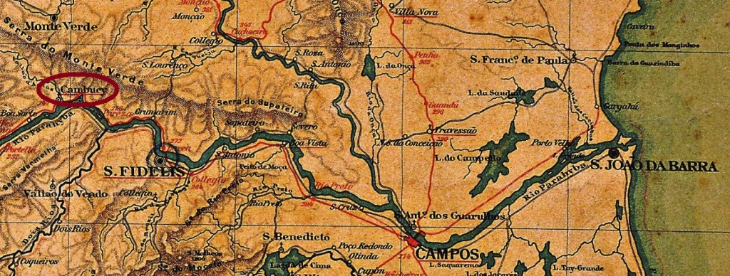
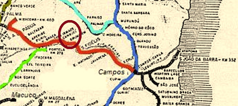
This station was inaugurated in July 1880 by the E.F. Santo Antonio de Padua Railway Company and was located on the north bank of the Paraíba do Sul River in the Município of São Fidélis, 300 km northeast of the capital Rio de Janeiro. The line changed hands in 1884 to E.F. Macahe e Campos, in 1887 to E.F. Leopoldina, and from 1975 until its closure in 1996 it belonged to Rede Ferroviária Federal S.A. (estacoesferroviarias.com.br). The name Vallão das Antas means Creek of the Tapirs, but from about 1886 the station was renamed Cambucy. The local jurisdiction changed to the Município of Monte Verde in May 1891, and since October 1918 Cambuci (as it is written today) has been an independent municipality.
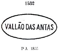
As listed in the Directory of Imperial Post Offices (Tabella das Agencias do Correio do Imperio, Rio de Janeiro, 1885), there was a station post office from 1880. The imperial postmark from this is VRJ-0980a, as shown in the Paulo Ayres (Catálogo de Carimbos Brasil-Império, S. Paulo, 1937, 1942):
VRJ-0980a (P.A. 1532) 1880-1885ff
For postmarks with Cambucy (from 1886) see R. Koester: Carimbologia VIII.
Estrada de Ferro Leopoldina
Dieser Bahnhof wurde im Juli 1880 durch die E.F. Santo Antonio de Padua Bahngesellschaft eingeweiht und lag im Município von São Fidélis, 300 km nordöstlich der Hauptstadt Rio de Janeiro entfernt. Die Linie wechselte 1884 zur E.F. Macahe e Campos, 1887 zur E.F. Leopoldina, und von 1975 bis zur Stilllegung 1996 gehörte sie der Rede Ferroviária Federal S.A. (estacoesferroviarias.com.br). Der Name Vallão das Antas bedeutet Graben der Tapire, aber ab ca. 1886 hieß der Bahnhof Cambucy. Die Ortszuständigkeit wechselte im Mai 1891 zum Município von Monte Verde, und seit Oktober 1918 ist Cambuci (wie man es heute schreibt) ein eigenständiger Município.
Wie im Verzeichnis der kaiserlichen Postämter (Tabella das Agencias do Correio do Imperio, Rio de Janeiro, 1885) aufgelistet, gab es ein Bahnhofspostamt ab 1880. Das kaiserliche Poststempel davon ist VRJ-0980a, wie im Paulo Ayres (Catálogo de Carimbos Brasil-Império, S. Paulo, 1937, 1942) abgebildet:
VRJ-0980a (P.A. 1532) 1880-1885ff
Für Poststempel mit Cambucy (ab 1886) siehe R. Koester: Carimbologia VIII.
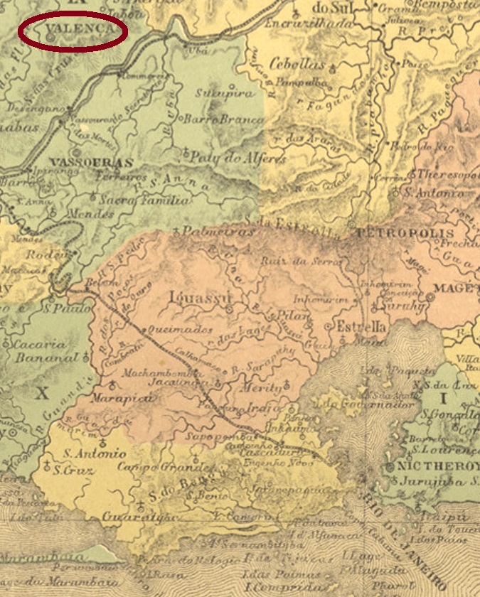
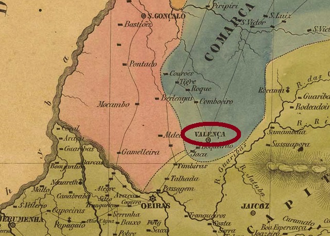
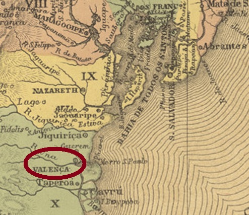
The Freguesia of Nossa Senhora da Glória de Valença was founded in August 1808, located 150 km northwest of the capital Rio de Janeiro. It was already elevated to Vila in August 1823. Valença has been a town since September 1857. In May 1871, a railway station of the E.F. Valenciana railway company, Jacutinga branch, was inaugurated there. The railway line belonged to the E.F. Central do Brasil in 1910 until its closure in 1970.
Now for the post offices. Nova Monteiro writes in Administrações e Agencias Postaes do Brasil Imperio (Brasil Filatelico/RJ, 1934-5; Reprint SPP 1994-1999) that there was a local post office there from June 1829. The first two postmarks are very similar and thus bring a risk of confusion. VRJ-0975a has already been presented in the RHM catalogue under P-RJ-45:
VRJ-0975a (RHM P-RJ-45) 1842-1869
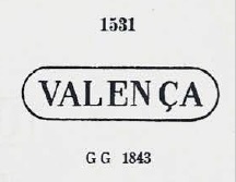
VRJ-0975b was also in use at about the same time. This cancel is in Paulo Ayres (Catálogo de Carimbos Brasil-Império, S. Paulo, 1937, 1942) with no. 1531 and, unlike the previous one, has rounded corners and no dot at the end:
VRJ-0975b (P.A. 1531) 1843-1869
Three postmarks as double circles followed. VRJ-0975c (Coll. Fuad Ferreira Fo.) is a French type with the inscription VALENÇA above and the star between brackets below. The dates in the centre go from 1874 to 1879. VRJ-0975d was added somewhat later, as can be seen in Paulo Ayres (op.cit.) on p. 126:
VRJ-0975d (P.A. p./p. 126) 1878ff-1892
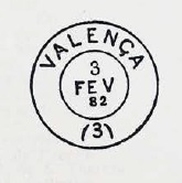
The last place cancel in the Empire is probably VRJ-0975e (Coll. Fuad Ferreira Fo.). This double circle has the same inscription at the top as its predecessors, but now has an eight-pointed star at the bottom. The dates in the middle go from 1888 to 1890.
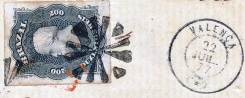
From the station post office comes VRJ-0976a (agenciaspostais.com.br): a double circle with the inscription EST. DE VALENÇA. The only example so far has a date from 1888 in the centre.
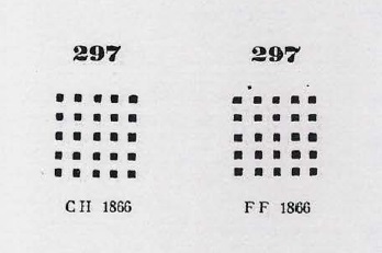
There are also mute cancellations from Valença. Paulo Ayres shows two variants here under no. 297. This cancel was often used in conjunction with VRJ-0975a and VRJ-0975b:
P.A. 297 (BPA 2992) 1868-1877 (JJ)
From the Luis Claudio Fritzen collection there comes a previously unrecorded mute cancel:
1877 (LCF)Villiers de l’Ile Adam: Carta (…) da Provincia do Rio de Janeiro, 1850
Die Freguesia von Nossa Senhora da Glória de Valença wurde im August 1808 gegründet und lag 150 km nordwestlich der Hauptstadt Rio de Janeiro entfernt. Sie wurde bereits im August 1823 zur Vila erhoben. Seit September 1857 ist Valença eine Stadt. Im Mai 1871 wurde dort ein Bahnhof der E.F. Valenciana Bahngesellschaft, Jacutinga-Abzweigung, eingeweiht. Die Bahnlinie gehörte 1910 bis zur Stilllegung 1970 der E.F. Central do Brasil.
Nun zu den Postämtern. Nova Monteiro schreibt in Administrações e Agencias Postaes do Brasil Imperio (Brasil Filatelico/RJ, 1934-5; Reprint SPP 1994-1999), dass es dort ab Juni 1829 ein Ortspostamt gab. Die ersten beiden Poststempel sind sich sehr ähnlich und bringen dadurch Verwechslungsgefahr. VRJ-0975a wurde bereits im RHM Katalog unter P-RJ-45 vorgestellt:
VRJ-0975a (RHM P-RJ-45) 1842-1869
Etwa zur gleichen Zeit war auch VRJ-0975b in Gebrauch. Dieser Stempel steht in Paulo Ayres (Catálogo de Carimbos Brasil-Império, S. Paulo, 1937, 1942) mit Nr. 1531 und hat – in Unterschied zum vorigen – abgerundete Ecken und keinen Punkt am Ende:
VRJ-0975b (P.A. 1531) 1843-1869
Es folgten drei Poststempel als Doppelkreise. VRJ-0975c (Samml. Fuad Ferreira Fo.) ist ein französischer Typus mit der Inschrift VALENÇA oben und dem Stern zwischen Klammern unten. Die Daten in der Mitte gehen von 1874 bis 1879. Etwas später kam VRJ-0975d dazu, wie im Paulo Ayres (op.cit.) auf S. 126 zu sehen ist:
VRJ-0975d (P.A. p./S. 126) 1878ff-1892
Der letzte Ortsstempel im Kaiserreich dürfte VRJ-0975e (Samml. Fuad Ferreira Fo.) sein. In diesem Doppelkreis hat man oben die gleiche Inschrift wie bei seinen Vorgängern, unten ist nun ein achtzackiger Stern zu sehen. Die Daten in der Mitte gehen von 1888 bis 1890.
Aus dem Bahnhofspostamt kommt VRJ-0976a (agenciaspostais.com.br): ein Doppelkreis mit der Inschrift EST. DE VALENÇA. Das bisher einzige Beispiel hat ein Datum aus 1888 in der Mitte.
Auch stumme Abstempelungen aus Valença sind vorhanden. Paulo Ayres zeigt hier gleich zwei Varianten unter Nr 297. Dieser Stempel wurde oft in Verbindung mit den beiden ersten Ortsstempel verwendet:
P.A. 297 (BPA 2992) 1868-1877 (JJ)
Aus der Sammlung Luis Claudio Fritzen kommt ein bisher unterfasstet stummer Stempel:
Villiers de l’Ile Adam: Carta (…) da Provincia do Piauhy, 1850
Other names: Berlengas, Valença do Piauí (1948)
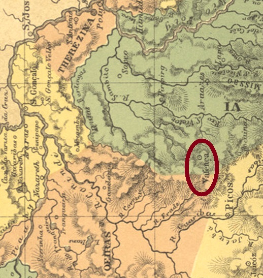
This other Valença locality, now in northern Brazil, was already a vila in June 1761, located on the west bank of the Valentim River, over 200 km southeast of the future provincial capital of Teresina. In December 1889, it was elevated to the status of a town, after which the place name changed twice: in December 1943 to Berlengas and in July 1948 to Valença do Piauí, which is still current today.
Two years of origin for the local post office were found here. First in January 1831, as can be read in Nova Monteiro (Administrações e Agencias Postaes do Brasil Imperio, in Brasil Filatelico/RJ, 1934-5; Reprint SPP 1994-1999). Then again in 1883, as listed in the Directory of Imperial Post Offices (Tabella das Agencias do Correio do Imperio, Rio de Janeiro, 1885). Again, the very first postmark is unknown, and the last confirmation is still missing for VPI-0175b (Coll. José A. Junges). In this double circle, one reads VALENÇA at the top, while there is a (2) at the bottom. The only specimen so far is dated 1888 in the centre.
Atlas do Imperio do Brasil, 1868
Andere Namen: Berlengas, Valença do Piauí (1948)
Diese andere Valença-Ortschaft im Norden Brasiliens war bereits im Juni 1761 eine Vila, die am Westufer des Valentim-Flusses lag, über 200 km südöstlich der künftigen Provinzhauptstadt Teresina entfernt. Im Dezember 1889 wurde sie zur Stadt erhoben, danach wechselte der Ortsname zweimal: im Dezember 1943 zu Berlengas und im Juli 1948 zum heute noch aktuellen Valença do Piauí.
Hier wurden zwei Entstehungsjahre fürs örtliche Postamt gefunden. Erstmals im Januar 1831, wie bei Nova Monteiro (Administrações e Agencias Postaes do Brasil Imperio, in Brasil Filatelico/RJ, 1934-5; Reprint SPP 1994-1999) zu lesen ist. Dann wieder 1883, wie im Verzeichnis der kaiserlichen Postämter (Tabella das Agencias do Correio do Imperio, Rio de Janeiro, 1885) aufgelistet. Auch hier ist der allererste Poststempel noch unbekannt, und für VPI-0175b (Samml. José A. Junges) fehlt die letzte Bestätigung. In diesem Doppelkreis liest man oben VALENÇA, während unten eine (2) steht. Das bisher einzige Exemplar ist mit 1888 in der Mitte datiert.
Villiers de l’Ile Adam: Carta (…) da Provincia da Bahia, 1848
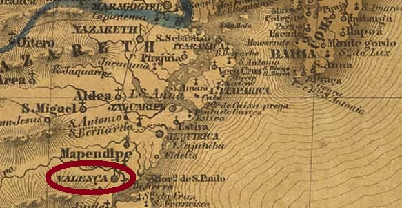
The settlement of Nova Valença do Santissimo Coração de Jesus (New Valencia of the Sacred Heart of Jesus) was founded in the 18th century in the Vila of Cairu, 120 km south of the future provincial capital Salvador da Bahia. The village was elevated to freguesia status in September 1801 and from November 1849 it was a town in its own município.
As Nova Monteiro writes in Administrações e Agencias Postaes do Brasil Imperio (Brasil Filatelico/RJ, 1934-5; Reprint SPP 1994-1999), there was a post office there from May 1832. Here again, the very first postmark has not yet been found, and for VBA-0860b (Coll. José A. Junges), final confirmation of its assignment is still missing. In this double circle one reads VALENÇA above, below there is an (I), and the only specimen was found on a D. Pedro issue of 1884.
Atlas do Imperio do Brasil, 1868
Die Siedlung von Nova Valença do Santissimo Coração de Jesus (Neu-Valencia vom Hochheiligen Herz Jesu) wurde im 18. Jahrhundert in der Vila von Cairu gegründet und lag 120 km südlich der künftigen Provinzhauptstadt Salvador da Bahia entfernt. Der Ort wurde im September 1801 zur Freguesia erhoben und ab November 1849 war er eine Stadt im eigenen Município.
Wie Nova Monteiro im Administrações e Agencias Postaes do Brasil Imperio (Brasil Filatelico/RJ, 1934-5; Reprint SPP 1994-1999) schreibt, gab es dort ein Postamt ab Mai 1832. Auch hier konnte der allererste Poststempel noch nicht gefunden werden, und für VBA-0860b (Samml. José A. Junges) fehlt noch die endgültige Bestätigung seiner Zuordnung. In diesem Doppelkreis liest man VALENÇA oben, unten gibt es eine (I), und das einzige Exemplar wurde auf eine D. Pedro-Ausgabe von 1884 gefunden.
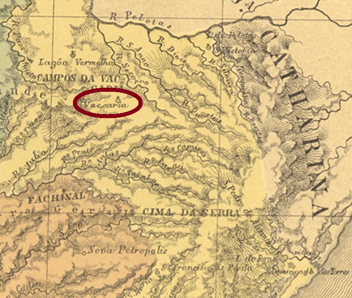
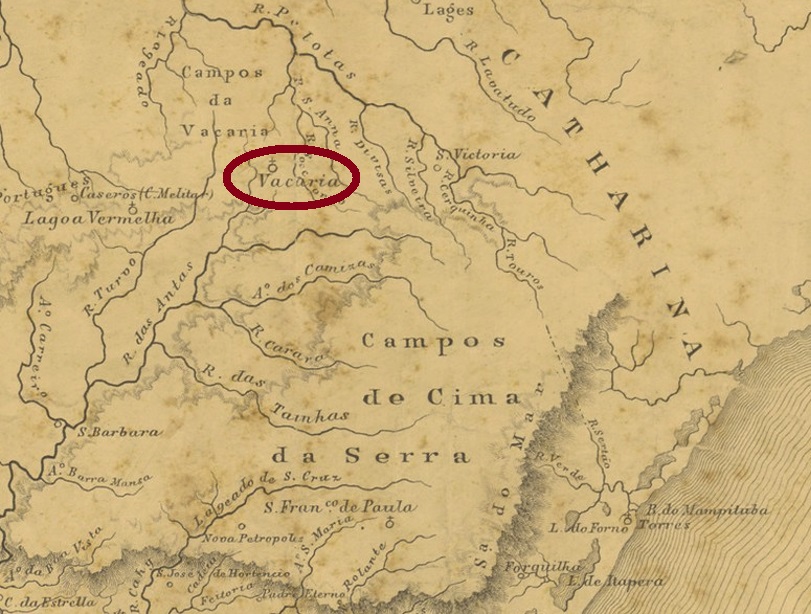
The chapel of Nossa Senhora de Vaccaria was built in December 1761 and was located 240 km north of the future provincial capital Porto Alegre. In October 1805, it was elevated to the Freguesia of the Vila of Sto. Antonio da Patrulha, and from April 1878 Vaccaria was an independent vila.
As Nova Monteiro writes in Administrações e Agencias Postaes do Brasil Imperio (Brasil Filatelico/RJ, 1934-5; Reprint SPP 1994-1999), there was a post office there from September 1857. Two postmarks have been found for the 19th century, unfortunately not the oldest of them. VRS-0475b (Coll. José A. Junges) is a double circle with the inscription VACCARIA at the top and an ornament at the bottom formed by two triangles stacked on top of each other. The dates in the centre were found for the period 1876ff-1886. The double circle VRS-0475c (Coll. José A. Junges) probably already comes from the Republic and has the same inscription at the top. The bottom now reads (S. PEDRO DO SUL), with internal dates from 1901 to 1908.
Provincia de São Pedro do Rio Grande, 1877
Die Kapelle von Nossa Senhora de Vaccaria wurde im Dezember 1761 errichtet und lag 240 km nördlich der künftigen Provinzhauptstadt Porto Alegre entfernt. Im Oktober 1805 wurde sie zur Freguesia der Vila von Sto. Antonio da Patrulha erhoben, und ab April 1878 war Vaccaria eine eingenständige Vila.
Wie Nova Monteiro in Administrações e Agencias Postaes do Brasil Imperio (Brasil Filatelico/RJ, 1934-5; Reprint SPP 1994-1999) schreibt, gab es dort ein Postamt ab September 1857. Zwei Poststempel wurden für das 19. Jahrhundert gefunden, leider nicht der älteste davon. VRS-0475b (Samml. José A. Junges) ist ein Doppelkreis mit der Inschrift VACCARIA oben und einem Ornament unten, das aus zwei aufeinander gestapelten Dreiecken gebildet wird. Die Daten in der Mitte wurden für den Zeitraum 1876ff-1886 gefunden. Der Doppelkreis VRS-0475c (Samml. José A. Junges) kommt wohl schon aus der Republik und hat oben die gleiche Inschrift. Unten liest man nun (S. PEDRO DO SUL), mit inneren Daten von 1901 bis 1908.
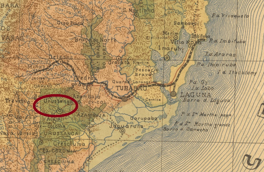
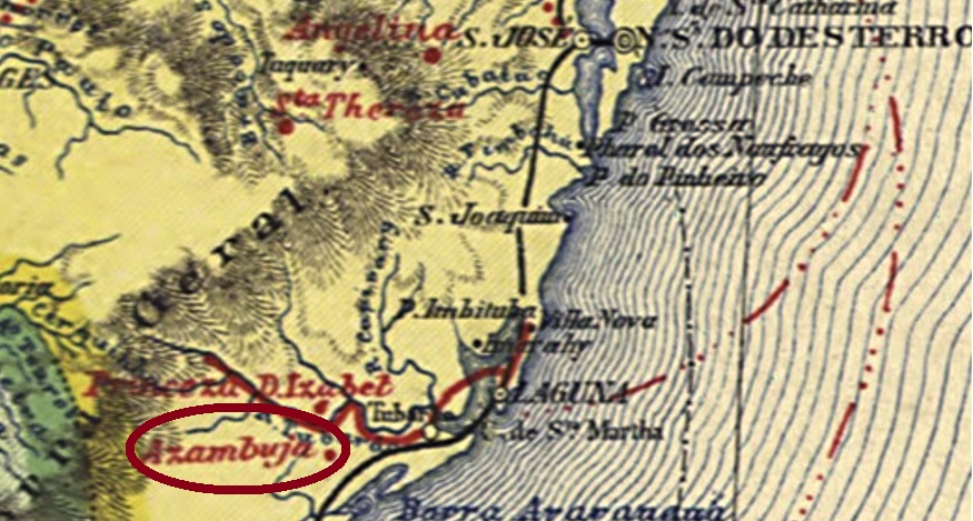
This locality was a settlement of Italian immigrants from May 1878, subordinate to the Vila of Tubarão and located 180 km south of the provincial capital of Desterro (now Florianópolis). It was not until the Republic, in June 1891, that the district was founded, but just nine years later, in October 1900, Urussanga became a vila in its own município. The Indian name is said to mean very cold water.
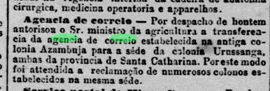
According to the Rio Press, there had been a post office there since September 1887:
Jornal do Commercio/RJ, 06.09.1887
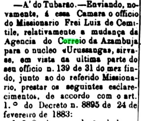
This post office had been created by moving the agency from Azambuja, which was also a colony in the region. The move was a long-held wish of the community, as a note in the regional press from November 1885 reveals:
Conservador, 25.11.1885
So far, no imperial-era postmark has been seen from Urussanga.
Carta da Republica dos Estados Unidos do Brazil, 1892
Diese Ortschaft war ab Mai 1878 eine Siedlung von italienischen Einwanderern, die der Vila von Tubarão unterordnet war und 180 km südlich der Provinzhauptstadt Desterro (heute Florianópolis) lag. Erst in der Republik, im Juni 1891, wurde der Distrikt gegründet, aber gleich neun Jahre später, im Oktober 1900, wurde aus Urussanga eine Vila im eigenen Município. Der indianische Name soll sehr kaltes Wasser bedeuten.
Wie aus der Rio-Presse zu entnehmen ist, gab es dort ein Postamt seit September 1887:
Jornal do Commercio/RJ, 06.09.1887
Dieses Postamt war durch den Umzug der Postagentur aus Azambuja entstanden, auch eine Kolonie der Region. Der Umzug war ein lang gehegter Wunsch der Gemeinde, wie eine Notiz der Regionalpresse aus November 1885 verrät:
Conservador, 25.11.1885
Bisher war kein Poststempel aus der Kaiserzeit aus Urussanga zu sehen.
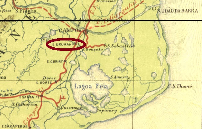
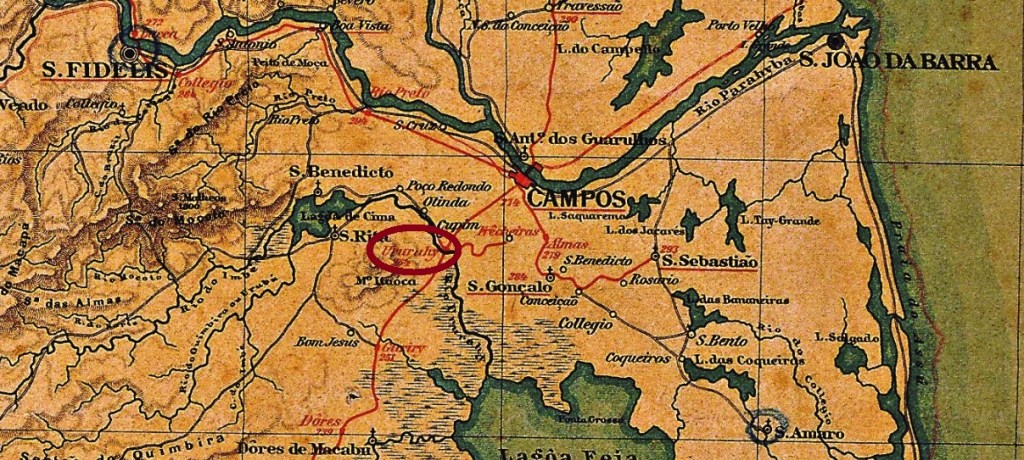
Ururahy station was inaugurated around 1875 by the Estrada de Ferro de Macahe a Campos railway company and was located on the east bank of the river of the same name in the Município of Campos, 260 km northeast of the capital Rio de Janeiro. The railway line became part of the Estrada de Ferro Leopoldina in 1887 and from 1975 until its closure in 1996 it belonged to Rede Ferroviária Federal S.A. (estacoesferroviarias.com.br). Around 1945, the station and town name changed to Cupim, which is now a rural suburb southwest of Campos dos Goytacazes.
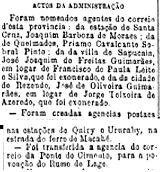
According to the Rio press, there was a post office at the station from September 1889:
Diario do Commercio, 20.09.1889
So far, no imperial-era postmark has been seen from this station.
Almanak Laemmert, 1892
Anderer Name: Cupim
Der Bahnhof Ururahy wurde um 1875 durch die Estrada de Ferro de Macahe a Campos Bahngesellschaft eingeweiht und lag am Ostufer des gleichnamigen Flusses im Município von Campos, 260 km nordöstlich der Hauptstadt Rio de Janeiro entfernt. Die Bahnlinie ging 1887 zur Estrada de Ferro Leopoldina über und von 1975 bis zur Stilllegung 1996 gehörte sie der Rede Ferroviária Federal S.A. (estacoesferroviarias.com.br). Gegen 1945 wechselten der Bahnhofs- und Ortsname zu Cupim, der heute ein ländlicher Vorort südwestlich von Campos dos Goytacazes ist.
Wie aus der Rio-Presse zu entnehmen ist, gab es ein Postamt am Bahnhof seit September 1889:
Diario do Commercio, 20.09.1889
Bisher war kein Poststempel aus der Kaiserzeit aus diesem Bahnhof zu sehen.