Categories
Carimbologia T-Z

Una (train station/Bahnhof), Pernambuco (UPE-0731)

Carta Corographica da Provincia de Pernambuco, 1880

See also Trombetas (TPE-0657)

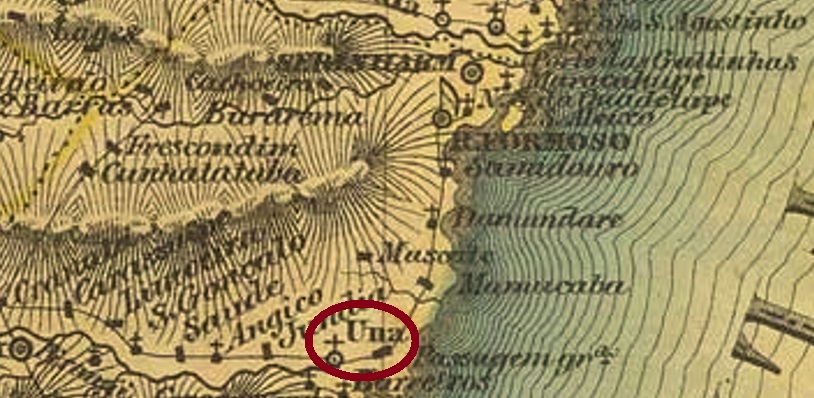
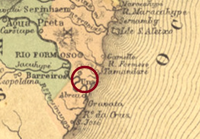
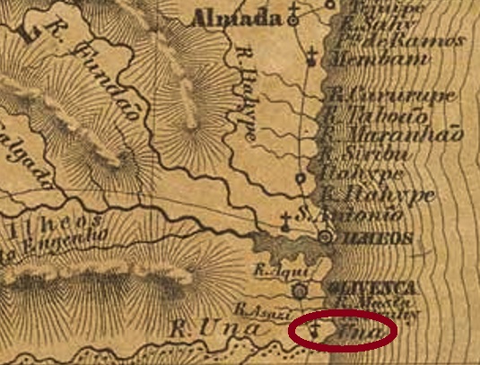
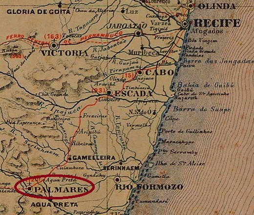
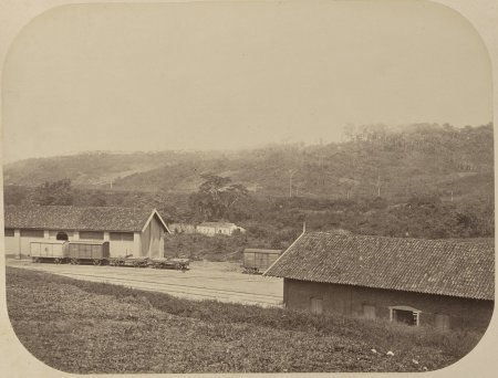
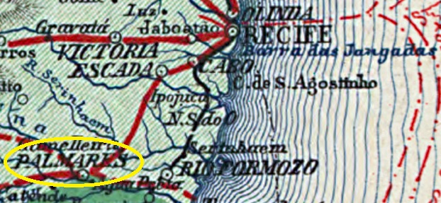
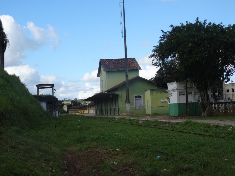
Una station was inaugurated in November 1862 by the E.F. Recife ao São Francisco railway company (Southern Line) and was then located in the Município of Água Preta on the north bank of the Una River, 120 km southwest of the provincial capital Recife. Despite the name, the station did not serve the Freguesia of Una near Rio Formoso (UPE-0730, post office since 1854), but the nearby large estate (Engenho) of Trombeta. The railway line went to the Great Western Company in 1901, to Rede Ferroviária do Nordeste in 1950, and from 1975 until its closure in 1996 it belonged to Rede Ferroviária Federal S.A. (estacoesferroviarias.com.br). Today, the station building houses a cultural foundation dedicated to the writer Hermilo Borba Filho (1917-1976).

ca. 1875 (Commissão Geologica do Imperio, in estacoesferroviarias.com.br)
2016 (Photo: Fernando Marietan, in estacoesferroviarias.com.br)

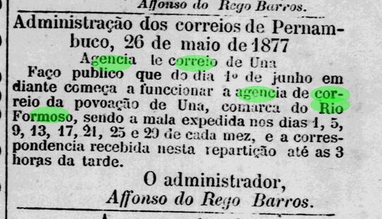
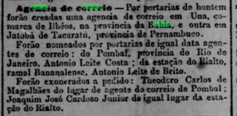
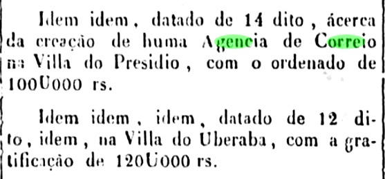
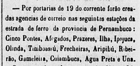
The station post office was created in December 1864, as reported by the Rio press:

Constitucional/RJ, 24/12/1864

The village between the engenho and the railway station continued to grow, and in September 1866 Trombetas also received its own post office. Shortly after, the population increased very rapidly, due to the arrival of the descendants of escaped slaves from Palmares Quilombo in Alagoas. As early as 1868, the town was elevated to a district called Palmares, and five years later it became a villa, with a population of over 25 thousand by the end of the Empire. Between 1875 and 1879, the station was renamed Palmares.

So far, no postmark of Una station for the imperial period could be identified with certainty. For postmarks with PALMARES see Koester, Carimbologia XXIX.

Carta da Republica dos Estados Unidos do Brazil, 1892

Siehe auch Trombetas (TPE-0657)

Der Bahnhof Una wurde im November 1862 von der E.F. Recife ao São Francisco Bahngesellschaft (Südlinie) eingeweiht und lag damals im Município von Água Preta am Nordufer des Flusses Una, 120 km südwestlich der Provinzhauptstadt Recife entfernt. Trotz des Namens diente der Bahnhof nicht die Freguesia von Una bei Rio Formoso (UPE-0730, Postamt seit 1854), sondern den nahen Großlandbesitz (Engenho) Trombetas. Die Bahnhlinie ging 1901 zur Great Western Gesellschaft, 1950 zur Rede Ferroviária do Nordeste, und von 1975 bis zur Stilllegung 1996 gehörte sie der Rede Ferroviária Federal S.A. (estacoesferroviarias.com.br). Heute beherbergt das Bahnhofsgebäude eine dem Schriftsteller Hermilo Borba Filho (1917-1976) gewidmete Kulturstiftung.

ca. 1875 (Commissão Geologica do Imperio, in estacoesferroviarias.com.br)
2016 (Foto: Fernando Marietan, in estacoesferroviarias.com.br)

Im Dezember 1864 entstand das Bahnhofspostamt, wie die Presse aus Rio berichtet:

Constitucional/RJ, 24.12.1864

Die Ortschaft zwischen dem Engenho und dem Bahnhof wuchs weiter, und im September 1866 erhielt auch Trombetas ein eigenes Postamt. Kurz darauf stieg die Einwohnerzahl sehr rasch, bedingt durch die Ankunft des Nachkommens von geflohenen Sklaven aus dem Quilombo Palmares in Alagoas. Bereits 1868 wurde der Ort zu einem Distrikt namens Palmares erhoben und fünf Jahre später zu einer Villa, die am Ende des Kaiserreichs über 25 Tausend Einwohner hatte. Zwischen 1875 und 1879 wurde der Bahnhof zu Palmares umbenannt.

Bisher konnte kein Poststempel des Bahnhofs Una für die Kaiserzeit mit Sicherheit identifiziert werden. Für Stempel mit PALMARES siehe Koester, Carimbologia XXIX.

Categories
Carimbologia T-Z

Una, Pernambuco (UPE-0730)

Villiers de l’Ile Adam: Carta (…) das Provincias de Pernambuco, Alagoas e Sergipe, 1847

Updated on April 7, 2022

This other locality called Una, in the province of Pernambuco, was already before 1831 the Freguesia of N. Sa. da Purificação e São Gonçalo de Una, which was directly subordinate to Recife, although it was about 100 km south of the main city. In May 1833, the freguesia changed to the Município of Rio Formoso, and 100 years later to the Município of Barreiros. And so it has remained until today as the district of Rio Una at Barreiros.

Two years were found for the creation of the local post office. Firstly in 1854, as noted in the Directory of Imperial Post Offices (Tabella das Agencias do Correio do Imperio, Rio de Janeiro, 1885). Then again in 1877, as shown in the regional press:

 Diario de Pernambuco, 28.05.1877

An imperial postmark of this locality could be assigned with certainty so far, but not the oldest one. UPE-0730b (Coll. Ginaldo Bezerra da Silva) is a double circle with the inscription UNA above and one (2) below. The dates in the middle were found for the period 1887-1890ff.

Atlas do Imperio do Brasil, 1868

Aktualisiert am 07.04.2022

Diese andere Ortschaft namens Una in der Provinz Pernambuco war bereits vor 1831 die Freguesia von N. Sa. da Purificação e São Gonçalo de Una, die direkt Recife unterstellt war, obwohl sie ca. 100 km südlich der Hauptsstadt lag. Im Mai 1833 wechselte die Freguesia zum Município von Rio Formoso, und 100 Jahre später zum Município von Barreiros. Und so es bis heute der Ortsteil Rio Una bei Barreiros geblieben.

Zwei Entstehungsjahre fürs örtliche Postamt wurden gefunden. Erstmals 1854, wie im Verzeichnis der kaiserlichen Postämter (Tabella das Agencias do Correio do Imperio, Rio de Janeiro, 1885) vermerkt. Dann wieder 1877, wie aus der regionalen Presse hervorgeht:

 Diario de Pernambuco, 28.05.1877

Ein kaiserlicher Poststempel dieser Ortschaft konnte bisher mit Sicherheit zugeordnet werden, nicht aber der älteste. UPE-0730b (Samml. Ginaldo Bezerra da Silva) ist ein Doppelkreis mit der Inschrift UNA oben und eine (2) unten. Die Daten in der Mitte wurden für den Zeitraum 1887-1890ff gefunden.

Categories
Carimbologia T-Z

Una, Bahia (UBA-0750)

Villiers de l’Ile Adam: Carta (…) da Provincia da Bahia, 1848

Other names: Barra de Una, Cachoeirinha

This village was a freguesia near Ilhéus from July 1860, located on the north bank of the Una River, 380 km south of the provincial capital Salvador da Bahia. In August 1923, the place – now under the name Cachoeirinha – changed to the newly founded município of Canavieiras. Exactly one year later, it became a vila, and since January 1939 it has again borne the old place name of Una.

The local post office was creatd in February 1885, according to the Rio press:

Jornal do Commercio/RJ, 04.02.1885

So far, no imperial postmark could be surely assigned to this locality.

Atlas do Imperio do Brasil, 1868

Andere Namen: Barra de Una, Cachoeirinha

Diese Ortschaft war ab Juli 1860 eine Freguesia bei Ilhéus, die am Nordufer des Flusses Una lag, 380 km südlich der Provinzhauptstadt Salvador da Bahia entfernt. Im August 1923 wechselte der Ort – nun unter dem Namen Cachoeirinha – zum neu gegründeten Município von Canavieiras. Genau ein Jahr später folgte der Aufstieg zu einer Vila, die seit Januar 1939 den alten Ortsnamen Una wieder trägt.

Das örtliche Postamt entstand im Februar 1885, wie die Presse aus Rio mitteilte:

Jornal do Commercio/RJ, 04.02.1885

Bisher konnte kein kaiserlicher Poststempel mit Sicherheit dieser Ortschaft zugeordnet werden.

Categories
Carimbologia T-Z

Umburanas (Feira de Sant’Anna), Bahia (UBA-0746)

Estado da Bahia, 1913

Other names: Capela de Sto. Estevão, Resgate de Umburanas, Uberlândia, Tinguatiba, Antonio Cardoso (1962)

The second Umburanas with post office in the imperial province of Bahia also has a turbulent history behind it. The former Capela de Santo Estêvão (St. Stephen’s Chapel) rose in April 1843 to become the Freguesia of Nossa Senhora do Resgate de Umburanas in the municipio of Cachoeira and was located close to the north bank of the Paraguaçu River, over 170 km northwest of the provincial capital Salvador da Bahia. In July 1876, the freguesia switched to the município of Feira de Sant’Anna, but returned to Cachoeira two years later. In July 1884, there was another change, this time to the município of São Gonçalo dos Campos. After that, the district was renamed twice: in November 1938 to Uberlândia and in December 1943 to Tinguatiba. It was not until April 1962 that the place would become the município of Antonio Cardoso. The name was supposed to commemorate a political leader of the area, who however was by no means very popular.

The local post office was established in 1876, according to the provincial president’s report for the following year:

Relatorio do Conselho Interino do Governo da Bahia, 1877

The post office must have had a very short operational life, as it was no longer listed in the Imperial Postal Guide (Guia Postal do Imperio) of 1880. No postmark from the Empire has been seen so far.

Google Maps

Andere Namen: Capela de Sto. Estevão, Resgate de Umburanas, Uberlândia, Tinguatiba, Antonio Cardoso (1962)

Die zweite Umburanas mit Postamt in der kaiserlichen Provinz Bahia hat ebenfalls eine bewegte Geschichte hinter sich. Die frühere Capela de Santo Estêvão (St. Stephanskapelle) stieg im April 1843 zur Freguesia de Nossa Senhora do Resgate de Umburanas im Municipio von Cachoeira und lag nah am Nordufer des Flusse Paraguaçu, gut 170 km nordwestlich der Provinzhauptstadt Salvador da Bahia entfernt. Im Juli 1876 wechselte die Freguesia zum Município von Feira de Sant’Anna, kam aber zwei Jahre später zurück zu Cachoeira. Im Juli 1884 gab es einen erneuten Wechsel, diesmal zum Município von São Gonçalo dos Campos. Danach wurde der Distrikt zweimal umbenannt: im November 1938 zu Uberlândia und im Dezember 1943 zu Tinguatiba. Erst im April 1962 stieg der Ort zum Município von Antonio Cardoso auf, der Name soll an einem politischen Führer der Gegend erinnern, der beileibe nicht besonders beliebt war.

Das örtliche Postamt entstand 1876, wie aus dem Bericht des Provinzpräsidenten fürs darauf folgende Jahr hervorgeht:

Relatorio do Conselho Interino do Governo da Bahia, 1877

Das Postamt hatte eine sehr kurze Betriebsdauer, denn es wurde nicht mehr im kaiserlichen Postführer (Guia Postal do Imperio, 1880) aufgelistet. Bisher war kein Poststempel aus dem Kaiserreich zu sehen.

Categories
Carimbologia T-Z

Umburanas (Caetités), Bahia (UBA-0745)

Carta da Republica dos Estados Unidos do Brazil, 1892

Other names: Villa Bella das Umburanas, Guirapá (1943)

In the imperial province of Bahia there were at least five localities called Umburanas, and when we know how difficult it is to get hold of 19th century postal objects from this area, the assignment of postmarks becomes a difficult task. Umburana, also called amburana or imburana, is the common name for a genus of plants in the Fabaceae family whose bark and seeds have valuable medicinal properties. The wood is also used to make cachaça barrels:

Amburana cearensis (Photo: Jorge Vallmitjana) 

The freguesia of São Sebastião do Amparo das Umburanas was created in July 1877 near Caetités, 700 km southwest of the provincial capital Salvador da Bahia. The village rose to become Villa Bella das Umburanas in July 1889, at a time when the economic decline could not be stopped anymore: in August 1918, Umburanas was demoted to the district of Urandy. In December 1943, the place name changed to the current Guirapá, which has been a district of the Município of Pindaí since February 1962. In the Indian language Tupi-guarani, Guirapá means crooked tree.

Two dates of origin have been found for the local post office. Firstly in 1863, as noted in the Directory of Imperial Post Offices (Tabella das Agencias do Correio do Imperio, Rio de Janeiro, 1885). And finally in August 1883, according to a press release from Rio de Janeiro:

Jornal do Commercio/RJ, 25/08/1883

The only imperial postmark so far is certainly not the oldest: UBA-0745b (Coll. José A. Junges) is a plain double circle with the inscription UMBURANAS at the top. The dates in the middle are from the period 1887-1891.

Estado da Bahia, 1913

Andere Namen: Villa Bella das Umburanas, Guirapá (1943)

In der kaiserlichen Provinz Bahia gab es mindestens fünf Ortschaften, die Umburanas hießen, und wenn wir wissen, wie schwer man an postalischen Belegen des 19. Jahrhunderts aus dieser Gegend kommt, wird die Zuordnung der Poststempel zu einer schwer lösbaren Aufgabe. Umburana, auch Amburana oder Imburana genannt, ist die allgemeine Bezeichnung für eine Pflanzengattung der Familie Fabaceae, deren Baumrinde und Samen wertvolle medizinische Eigenschaften aufweisen. Das Holz wird auch zur Herstellung von Cachaça-Fässern verwendet:

Amburana cearensis (Photo: Jorge Vallmitjana) 

Die Freguesia von São Sebastião do Amparo das Umburanas entstand im Juli 1877 bei Caetités und lag 700 km südwestlich der Provinzhauptstadt Salvador da Bahia. Der Ort stieg zwar im Juli 1889 zur Villa Bella das Umburanas, als der wirtschaftliche Rückgang der Region nicht mehr aufzuhalten war: im August 1918 war Umburanas zum Distrikt von Urandy degradiert. Im Dezember 1943 wechselte der Ortsname zum aktuellen Guirapá, der seit Februar 1962 ein Distrikt des Município von Pindaí ist. In der Indianersprache Tupi-guarani bedeutet Guirapá krummer Baum.

Zwei Entstehungszeitpunkte wurden fürs örtliche Postamt ermittelt. Erstmals 1863, wie im Verzeichnis der kaiserlichen Postämter (Tabella das Agencias do Correio do Imperio, Rio de Janeiro, 1885) vermerkt. Und schließlich im August 1883, nach einer Pressemitteilung aus Rio de Janeiro:

Jornal do Commercio/RJ, 25.08.1883

Der bisher einzige kaiserliche Poststempel ist bestimmt nicht der älteste: UBA-0745b (Samml. José A. Junges) ist ein schlichter Doppelkreis mit der Inschrift UMBURANAS oben. Die Daten in der Mitte entstammen dem Zeitraum 1887-1891.

Categories
Carimbologia T-Z

Umary, Ceará (UCE-0345)

Atlas do Imperio do Brasil, 1868

The district of Nossa Senhora da Conceição do Umary was founded in June 1860 at Lavras, on the provincial border with Parahyba, 400 km south of the capital Fortaleza. In November 1883, it was promoted to a Vila, but lost this status in October 1920 and once again became a district of Lavras. In May 1931, the town changed to the newly created Município of Baixio and finally emancipated itself in September 1956 as the Município of Umari. The name refers to a tree of the Fabaceae family:

Geoffroea spinosa/Jacq. (naturezabela.com.br)

There was a post office there from January 1887, according to the Provincial President’s report for July the same year:

Relatorio do Presidente da Provincia/CE, 07/1887

The 19th century postmark is UCE-0345a (Coll. José A. Junges): a double circle with the inscriptions UMARY above and (CEARÁ) below. The only specimen so far bears a date from 1893 in the centre.

Villiers de l’Ile Adam: Carta (…) da Provincia do Ceara, 1849

Der Distrikt von Nossa Senhora da Conceição do Umary wurde im Juni 1860 bei Lavras gegründet und lag an der Provinzgrenze zu Parahyba, 400 km südlich der Hauptstadt Fortaleza entfernt. Im November 1883 stieg der Ort zur Vila auf, verlor aber diesen Status im Oktober 1920 und wurde abermals ein Distrikt von Lavras. Im Mai 1931 wechselte der Ort zum neu gegründeten Município von Baixio und emanzipierte sich endgültig im September 1956 als der Município von Umari. Der Name bezieht sich auf einen Baum der Familie Fabaceae:

Geoffroea spinosa/Jacq. (naturezabela.com.br)

Dort gab es ein Postamt ab Januar 1887, wie aus dem Bericht des Provinzpräsidenten für Juli d. Js. hervorgeht:

Relatorio do Presidente da Provincia/CE, 07/1887

Der Poststempel des 19. Jahrhunderts ist UCE-0345a (Samml. José A. Junges): ein Doppelkreis mit den Inschriften UMARY oben und (CEARÁ) unten. Das bisher einzige Exemplar trägt ein Datum aus 1893 in der Mitte.

Categories
Carimbologia T-Z

Uberabinha, Minas Gerais (UMG-3250)

Atlas do Imperio do Brasil, 1868

Another name: Uberlândia (1929)

The history of this locality only began in July 1857, when the district of São Pedro da Uberabinha was created near Uberaba, some 630 km west of the provincial capital Ouro Preto. Rapid local development followed: in August 1888, the district was emancipated as Vila, which changed its name to Uberlândia in October 1929, probably to stop being associated with Uberaba. Towards the end of the Empire, Uberabinha had about 7,500 inhabitants; today, Uberlândia has almost a hundred times more. For comparison, Uberaba had about 12,000 inhabitants in 1890, today it has a good 340,000. Also noteworthy is the fact that Uberabinha can be seen on old maps to the southeast near Uberaba, while Uberlândia today lies to the north of it, closer to the Araguari River. Did a resettlement take place at some point? 

Paula Sobrinho writes in História Postal de Minas Gerais (Belo Horizonte, 1997) that there was a post office there since September 1883. The imperial postmark is UMG-3250a (Coll. José A. Junges): a double circle with the inscription UBERABINHA above and an ornament in ellipse below formed by four sickle-like figures.

Carta da Republica dos Estados Unidos do Brazil, 1892

Anderer Name: Uberlândia (1929)

Die Geschichte dieser Ortschaft fing erst im Juli 1857 an, als der Distrikt von São Pedro da Uberabinha bei Uberaba gegründet wurde, der etwa 630 km westlich der Provinzhauptstadt Ouro Preto entfernt lag. Es folgte eine rasche Ortsentwicklung: im August 1888 wurde der Distrikt als Vila emanzipiert, der seinen Namen im Oktober 1929 zu Uberlândia wechselte, wohl um nicht mehr als “Kleiner Uberaba” in Verbindung gebracht zu werden. Gegen Ende des Kaiserreichs hatte Uberabinha ca. 7.500 Einwohner, heute sind es in Uberlândia fast hundertmal mehr. Zum Vergleich: Uberaba hatte 1890 ca. 12.000 Einwohner, heute sind es gut 340.000. Auch bemerkenswert ist die Tatsache, dass Uberabinha auf alten Karten südöstlich in der Nähe von Uberaba zu sehen ist, während Uberlândia heute nördlich davon liegt, näher am Araguari-Fluss. Fand irgendwann eine Umsiedlung statt?  

Paula Sobrinho schreibt in História Postal de Minas Gerais (Belo Horizonte, 1997), dass es dort seit September 1883 ein Postamt gab. Der kaiserliche Poststempel ist UMG-3250a (Samml. José A. Junges): ein Doppelkreis mit der Inschrift UBERABINHA oben und einem Ornament in Ellipse unten, das aus vier sichelähnlichen Figuren gebildet wird.

Categories
Carimbologia T-Z

Uberaba, Minas Gerais (UMG-3245)

Atlas do Imperio do Brasil, 1868

Text update of June 2, 2024

The freguesia of Santo Antonio de Uberaba was founded in March 1820 and was located on the south bank of the Uberaba River in the villa of Araxá, 560 km west of the later provincial capital of Ouro Preto. In February 1836, the village rose to the status of a villa, which then became a town in May 1856.

Three dates of origin for the local post office have been handed down, whereby the first two are probably related to each other. The first one was on 12 December 1839, as reported by the Rio official press:

Correio Official/RJ, 31.12.1839

Nova Monteiro (Administrações e Agencias Postaes do Brasil Imperio, in Brasil Filatelico/RJ, 1934-5; Reprint SPP 1994-1999) and Paula Sobrinho (História Postal de Minas Gerais, Belo Horizonte, 1997) write a date only 6 days later for this. The last date would be in February 1860, as noted in the postal report (Relatorio Postal) for 1890. This last date is likely a reopening of the post office.

The first postmark is UMG-3245a, from the pre-philatelic period and has already been shown in the RHM catalogue:

UMG-3245a (RHM P-MG-66) 1839ff-1845

It was followed by UMG-3245b, presented by Paulo Ayres (Catálogo de Carimbos Brasil-Império, S. Paulo, 1937, 1942) under no. 1552:

UMG-3245b (P.A. 1552) 1856

UMG-3245c was also featured in the Paulo Ayres, this time under no. 1181:

UMG-3245c (P.A. 1181) 1846-1866ff

Three town postmarks as double circles came after that. The first one, UMG-3245d, also existed in blue and red, it was also shown by Paulo Ayres:

UMG-3245d (P.A. p. 126, recte JJ) 1882-1887

On UMG-3245e (Coll. José A. Junges) the outer circle is doubled, so we actually have three circles here. The inscription at the top reads UBERABA, at the bottom one reads MINAS GERAES between stars. The dates in the middle go from about 1885 to 1889. UMG-3245f (Coll. José A. Junges) could already be Republican. It bears the same inscription at the top; at the bottom there is now an ornament in cross with two horizontal arrows. Interior dates from 1890 to 1894.

Paulo Ayres (op.cit.) also shows us a mute cancellation from there, which was reproduced by J. Dingler and K.W. Lopes in Mute Cancellations of the Brazil Empire/ Carimbos Mudos do Brasil Império (Brazil Philatelic Association, Rio de Janeiro, 2000) under no. 2200:

P.A. 69 (BPA 2200) 1866ff
Villiers de l’Ile Adam: Carta (…) da Provincia de Minas Geraes, 1849

Textaktualisierung am 02. Juni 2024

Die Freguesia von Santo Antonio de Uberaba wurde im März 1820 gegründet und lag am Südufer des Flusses Uberaba bei der Villa de Araxá, 560 km westlich der späteren Provinzhauptstadt Ouro Preto. Im Februar 1836 stieg der Ort zur Vila auf, die dann im Mai 1856 zur Stadt wurde.

Drei Entstehungsdaten fürs örtliche Postamt sind überliefert, wobei die beiden ersten wohl im Zusammenhang miteinander stehen. Erstmals am 12. Dezember 1839, wie die Amtspresse in Rio berichtet:

Correio Official/RJ, 31.12.1839

Nova Monteiro (Administrações e Agencias Postaes do Brasil Imperio, in Brasil Filatelico/RJ, 1934-5; Reprint SPP 1994-1999) und Paula Sobrinho (História Postal de Minas Gerais, Belo Horizonte, 1997) schreiben dafür ein lediglich 6 Tage späteres Datum. Der letzte Termin wäre im Februar 1860, wie im Postbericht (Relatorio Postal) für 1890 vermerkt. Dies dürfte eine Wiedereröffnung des Postamts darstellen.

Der erste Poststempel ist UMG-3245a, der aus der Präphila-Zeit kommt und bereits im RHM-Katalog abgebildet wurde:

UMG-3245a (RHM P-MG-66) 1839ff-1845

Ihm folgte UMG-3245b, der uns von Paulo Ayres (Catálogo de Carimbos Brasil-Império, S. Paulo, 1937, 1942) unter Nr. 1552 vorgestellt wurde:

UMG-3245b (P.A. 1552) 1856

Auch UMG-3245c war im Paulo Ayres zu sehen, diesmal unter Nr. 1181:

UMG-3245c (P.A. 1181) 1846-1866ff

Danach kamen drei Ortsstempel als Doppelkreise. Den ersten davon, UMG-3245d, gab es auch in blau und rot, er wurde ebenfalls von Paulo Ayres abgebildet, allerdings gerieten hier die Buchstaben etwas zu groß:

UMG-3245d (P.A. p./S. 126, recte JJ) 1882-1887

Bei UMG-3245e (Samml. José A. Junges) ist der äußere Kreis verdoppelt, also haben wir hier eigentlich drei Kreise. Die Inschrift oben lautet UBERABA, unten liest man MINAS GERAES zwischen Sternen. Die Daten in der Mitte gehen von ca. 1885 bis 1889. UMG-3245f (Samml. José A. Junges) könnte bereits republikanisch sein. Er trägt die gleiche Inschrift oben; unten ist nun ein Ornament in Kreuz zu sehen, das zwei waagerechte Pfeile hat. Innere Daten von 1890 bis 1894.

Paulo Ayres (op.cit.) zeigt uns auch eine stumme Entwertung von dort, die auch von J. Dingler und K.W. Lopes in Mute Cancellations of the Brazil Empire/ Carimbos Mudos do Brasil Império (Brazil Philatelic Association, Rio de Janeiro, 2000) unter Nr. 2200 wiedergegeben wurde:

P.A. 69 (BPA 2200) 1866ff

Categories
Carimbologia T-Z

Ubatuba, São Paulo (USP-1445)

Atlas do Imperio do Brasil, 1868

The Arraial da Vila Nova da Exaltação da Santa Cruz do Salvador de Ubatuba (New Settlement of the Exaltation of the Holy Cross of the Saviour in Ubatuba) was already mentioned in documents in 1557. The place was declared a vila in October 1637 and a town in March 1855. The name Ubatuba has Indian origins and means landing place for many canoes.

Two dates of creation for the local post office were found. First in February 1833, as Nova Monteiro writes in Administrações e Agencias Postaes do Brasil Imperio (Brasil Filatelico/RJ, 1934-5; Reprint SPP 1994-1999). Then 1850, as listed in the Directory of Imperial Post Offices (Tabella das Agencias do Correio do Imperio, Rio de Janeiro, 1885). The first postmark USP-1445a is from the pre-philatelic period and has already been shown in the RHM catalogue under P-SP-58:

USP-1445a (RHM P-SP-58) 1833-1844ff

It was followed by two postmarks already shown in the Catálogo de Carimbos Brasil-Império (S. Paulo, 1937, 1942) by Paulo Ayres: USP-1445b, a.k.a. P. Ayres No. 1519, though here a point after the last letter is missing:

USP-1445b (P.A. 1519) 1850ff-1869, recte (JJ)

And USP-1445c, alias P. Ayres No. 1520:

USP-1445c (P.A. 1520) 1850ff-1866ff

Then there are two cancels in double circles. USP-1445d (Coll. José L. Fevereiro) is a French type, with the inscription UBATUBA above and the star between brackets below. The dates in the middle are from 1884 to 1888. USP-1445e (Coll. José A. Junges) is similar to its predecessor, but here the letters are slightly larger and the star at the bottom is missing. Dates: 1890 to 1893.

There are at least five mute cancellations from Ubatuba. Two of them are already registered by Paulo Ayres (op. cit.):

P.A. 248 (BPA 1272) 1866ff
P.A. 175 (BPA 539) 1878ff

Other two have been found by the philatelist Mario Celso Orsi Jr:

1854ff (MO)
1884 (MO)

The fifth mute cancel was seen in the collection of José A. Junges:

1854ff (JJ)
Villiers de l’Ile Adam: Carta (…) da Provincia de São Paulo, 1847

Der Arraial da Vila Nova da Exaltação da Santa Cruz do Salvador de Ubatuba (Neue Siedlung der Erhabenheit des Heiligen Kreuzes vom Erlöser in Ubatuba) wurde bereits 1557 urkundlich erwähnt. Der Ort wurde im Oktober 1637 zur Vila und im März 1855 zur Stadt erklärt. Der Name Ubatuba hat indianischen Ursprung und bedeutet Anlegestelle für viele Kanus.

Zwei Entstehungsdaten fürs örtliche Postamt waren zu finden. Erstmals im Februar 1833, wie Nova Monteiro in Administrações e Agencias Postaes do Brasil Imperio (Brasil Filatelico/RJ, 1934-5; Reprint SPP 1994-1999) schreibt. Dann 1850, wie im Verzeichnis der kaiserlichen Postämter(Tabella das Agencias do Correio do Imperio, Rio de Janeiro, 1885) aufgelistet. Der erste Ortsstempel USP-1445a stammt aus der Vorphila-Zeit und wurde im RHM-Katalog unter P-SP-58 bereits gezeigt:

USP-1445a (RHM P-SP-58) 1833-1844ff

Ihm folgten zwei Poststempel, die bereits im Catálogo de Carimbos Brasil-Império (S. Paulo, 1937, 1942) von Paulo Ayres zu sehen waren: USP-1445b, alias P. Ayres Nr. 1519, wobei hier noch ein Punkt nach dem letzten Buchstaben zu vermerken wäre:

USP-1445b (P.A. 1519) 1850ff-1869, recte (JJ)

Und USP-1445c, alias P. Ayres Nr. 1520:

USP-1445c (P.A. 1520) 1850ff-1866ff

Danach kamen zwei Stempel in Doppelkreisen. USP-1445d (Samml. José L. Fevereiro) ist ein französischer Typus, mit der Inschrift UBATUBA oben und dem Stern zwischen Klammern unten. Die Daten in der Mitte gehen von 1884 bis 1888. USP-1445e (Samml. José A. Junges) ist ähnlich wie sein Vorgänger, nun sind hier die Buchstaben etwas größer, und der Stern unten Fehlt. Daten: 1890 bis 1893.

Aus Ubatuba kommen noch mindestens fünf stumme Abstempelungen. Zwei davon sind durch Paulo Ayres (op. cit.) bereits registriert:

P.A. 248 (BPA 1272) 1866ff
P.A. 175 (BPA 539) 1878ff

Weitere zwei hat uns der Philatelist Mario Celso Orsi Jr. ausfindig gemacht:

1854ff (MO)
1884 (MO)

Der fünfte Stempel kommt aus der Sammlung José A. Junges:

1854ff (JJ)

Categories
Carimbologia T-Z

Ubá do Forquim, Minas Gerais (UMG-3240)

Estado de Minas Geraes, 1910

Other names: São Gonçalo do Ubá, Acaiaca (1923).

The name Forquim comes from Forca (fork), and Antonio Forquim da Luz the first settler in the region, who made it prosperous from about 1710 onwards through his constant search for precious metals. As the Brazilian statistics agency IBGE writes, this settlement was a district of Mariana as early as April 1844, and thus a good 30 years before it was designated a parish called São Gonçalo de Ubá, which was located on the north bank of the Carmo River, more than 50 km east of the provincial capital Ouro Preto. In September 1923, the place name changed to Acaiaca, and since December 1962, Acaiaca has been an independent Município. The Tupi language term refers to a cedar tree of the Meliaceae family:

Cedrela fissilis /Vell. (Wikiwand)

Paula Sobrinho writes in História Postal de Minas Gerais (Belo Horizonte, 1997) that there was a post office there since December 1880. At that time, the place was actually called São Gonçalo de Ubá, but the old name was apparently retained postally. The imperial postmark is UMG-3240a (Coll. José A. Junges): a double circle with the inscription UBÁ DO FORQUIM above and an ornament in lozenge below, formed by four small lozenges. The dates in the centre go from 1888 to 1909.

Google Maps

Andere Namen: São Gonçalo do Ubá, Acaiaca (1923)

Der Name Forquim kommt von Forca (Gabel), und Antonio Forquim da Luz hieß der erste Siedler der Region, der es ab ca. 1710 durch seine stetige Suche nach Edelmetall zum Wohlstand gebracht hat. Wie die brasilianische Statistikbehörde IBGE schreibt, war diese Siedlung bereits April 1844 ein Distrikt von Mariana, und damit gut 30 Jahre vor der Ernennung zu einer Pfarrei namens São Gonçalo de Ubá, die am Nordufer des Carmo-Flusses lag, über 50 km östlich der Provinzhauptstadt Ouro Preto entfernt. Im September 1923 änderte sich der Ortsname zu Acaiaca, und seit Dezember 1962 ist Acaiaca ein eigenständiger Município. Der Begriff der Tupi-Sprache bezieht sich auf einen Zederbaum der Meliaceae-Familie:

Cedrela fissilis /Vell. (Wikiwand)

Paula Sobrinho schreibt in História Postal de Minas Gerais (Belo Horizonte, 1997), dass es dort seit Dezember 1880 ein Postamt gab. Damals hieß der Ort eigentlich São Gonçalo de Ubá, aber der alte Name wurde offenbar postalisch beibehalten. Der kaiserliche Poststempel ist UMG-3240a (Samml. José A. Junges): ein Doppelkreis mit der Inschrift UBÁ DO FORQUIM oben und einem Ornament in Raute unten, das aus vier kleinen Rauten gebildet wird. Daten in der Mitte von 1888 bis 1909.