Categories
Carimbologia T-Z

Ubá (train station/Bahnhof), Rio de Janeiro (URJ-1915)

Atlas do Imperio do Brasil, 1868

Other names: Paty (Est./1886), Andrade Pinto (Est./1929)

See also Paty (R. Koester: Carimbologia XXX)

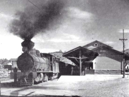
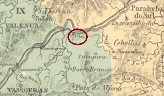
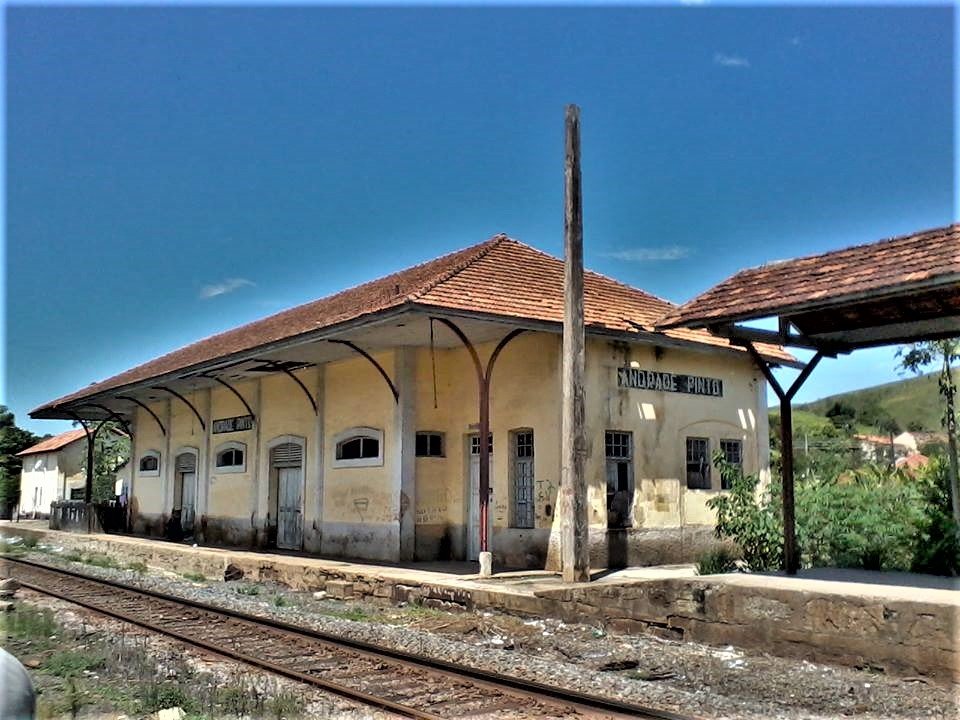
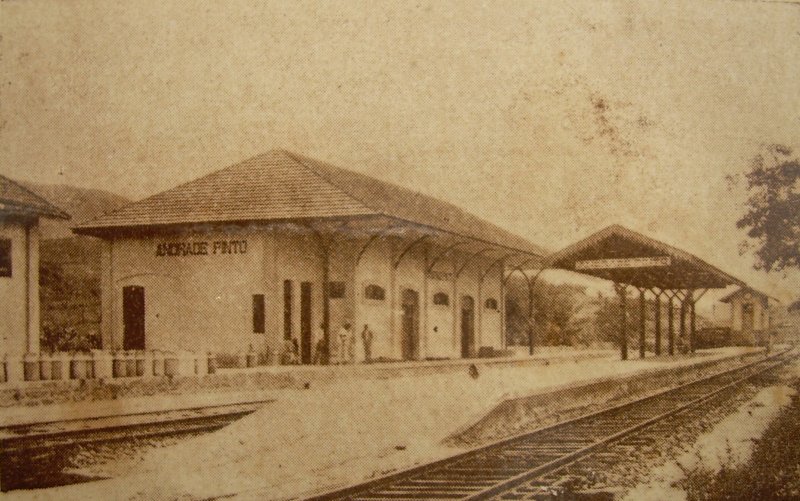
Ubá station was inaugurated in May 1867 by the E.F. Dom Pedro II Railway Company and was located on the main line near Vassouras, about 150 km north of the capital Rio de Janeiro. In 1886, the station name changed to Paty, probably to avoid confusion with Ubá in Minas Gerais. The line passed to E.F. Central do Brasil in 1889 and from 1975 to 1996 it belonged to Rede Ferroviária Federal S.A. (estacoesferroviarias.com.br).  The village around the station continued to grow and in September 1909 became a district called Paty. In 1929 the station name changed again, this time to Andrade Pinto, and the district followed this change in December 1938. Today the station building still stands:

Ca. 1930 (estacoesferroviarias.com.br)
around 2015 (Photo: Bruno Tavares, estacoesferroviarias.com.br)

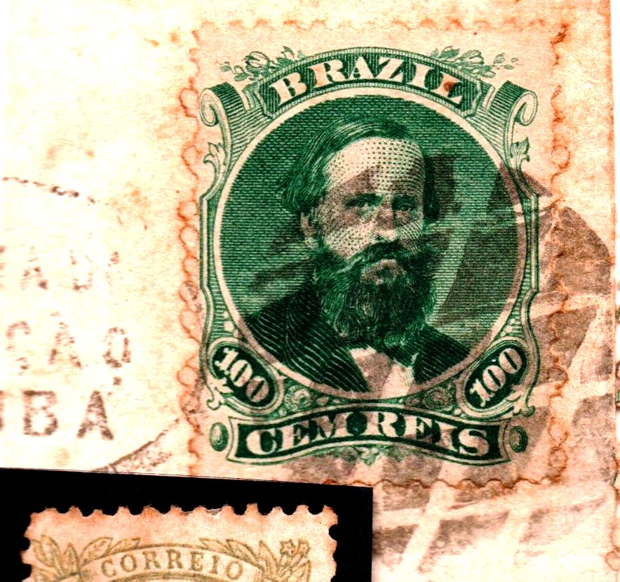
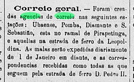
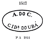
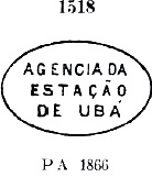
As Paulo Novaes writes in agenciaspostais.com.br, there was a post office there from July 1867. The first station cancel is URJ-1915a , which was in circulation until at least 1877 and has already been shown by Paulo Ayres in Catálogo de Carimbos Brasil-Império (S. Paulo, 1937, 1942) under number 1518:

URJ-1915a (P.A. 1518)

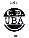
It was followed by two postmarks as double circles: URJ-1915b (Coll. José A. Junges) bears the inscriptions UBA above and (E) below, dated 1878-1879 in the middle. Then came URJ-1915c (Coll. José A. Junges). Here one reads E.DE UBÁ above, below is an ornament in lozenge, the four sides of which are open. The dates in the middle go from 1883 to 1886.

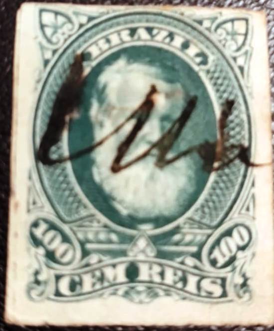
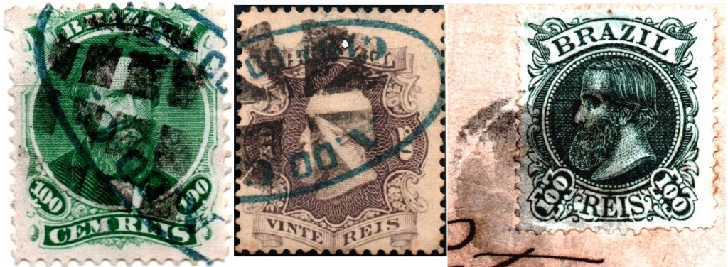
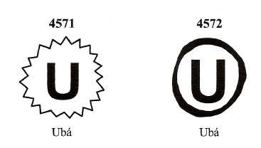
Paulo Ayres also shows two cancellations with initials from this station post office. Nos. 1091 and 1092 are also presented in Mute Cancellations of the Brazil Empire/ Carimbos Mudos do Brasil Império (Brazil Philatelic Association, Rio de Janeiro, 2000) under Nos. 4572 and 4571 respectively:

P.A. 1091 (BPA 4572) 1883ff – P.A. 1092 (BPA 4571) 1883ff-1884ff

From the José A. Junges collection there is another mute stamp, used in conjunction with URJ-1915a:

1867ff (JJ)
Estações Ferroviarias do Rio de Janeiro, São Paulo e Minas Geraes, 1880

Andere Namen: Paty (Est./1886), Andrade Pinto (Est./1929)

Siehe auch Paty (R. Koester: Carimbologia XXX)

Der Bahnhof Ubá wurde im Mai 1867 durch die E.F. Dom Pedro II Bahngesellschaft eingeweiht und lag auf der Hauptlinie bei Vassouras, ca. 150 km nördlich der Hauptstadt Rio de Janeiro entfernt. 1886 wechselte der Bahnhofsname zu Paty, wohl um Verwechslungen zu Ubá in Minas Gerais zu vermeiden. Die Linie ging 1889 zur E.F. Central do Brasil über und von 1975 bis 1996 gehörte sie der Rede Ferroviária Federal S.A. (estacoesferroviarias.com.br).  Der Ort um den Bahnhof wuchs weiter und wurde im September 1909 zu einem Distrikt namens Paty. 1929 änderte sich der Bahnhofname abermals, nun zu Andrade Pinto, der Distrikt folgte dieser Änderung im Dezember 1938. Heute steht noch das Bahnhofsgebäude:

Ca. 1930 (estacoesferroviarias.com.br)
ca.2015 (Foto: Bruno Tavares, estacoesferroviarias.com.br)

Wie Paulo Novaes in agenciaspostais.com.br schreibt, gab es dort ein Postamt ab Juli 1867. Der erst Bahnhofsstempel ist URJ-1915a , der bis mindestens 1877 im Umlauf war und bereits durch Paulo Ayres in Catálogo de Carimbos Brasil-Império (S. Paulo, 1937, 1942) unter der Nummer 1518 gezeigt wurde:

URJ-1915a (P.A. 1518)

Ihm folgten zwei Poststempel als Doppelkreise: URJ-1915b (Samml. José A. Junges) trägt die Inschriften UBA oben und (E) unten, datiert 1878-1879 in de Mitte. Danach kam URJ-1915c (Samml. José A. Junges). Hier liest man E.DE UBÁ oben und unten ist ein Ornament in Raute, dessen vier Seiten offen sind. Die Daten in der Mitte gehen von 1883 bis 1886.

Paulo Ayres zeigt auch zwei Initialstempel dieses Bahnhofspostamts. Nr. 1091 und 1092 werden auch in Mute Cancellations of the Brazil Empire/ Carimbos Mudos do Brasil Império (Brazil Philatelic Association, Rio de Janeiro, 2000) unter Nr. 4572 resp. 4571 vorgestellt:

P.A. 1091 (BPA 4572) 1883ff – P.A. 1092 (BPA 4571) 1883ff-1884ff

Und aus der Sammlung José A. Junges kommt ein weiterer stummer Stempel, der in Verbindung mit URJ-1915a angewendet wurde:

1867ff (JJ)

Categories
Carimbologia T-Z

Ubá (UMG-3235) – Ubá (train station/Bahnhof), Minas Gerais (UMG-3236)

Atlas do Imperio do Brasil, 1868

In April 1841, the Arraial (settlement) of São Januário do Ubá was officially founded in the Município of São João Baptista do Presídio. The settlement was located on the north bank of the Ubá Grande River, 160 km southeast of the provincial capital of Ouro Preto. In June 1853 it became a vila, and in July 1857 its name was shortened to Ubá. Between 1868 and March 1871, Ubá was a district of Visconde do Rio Branco. Then it became a vila again, and in July 1875 it was given the status of a town. The name Ubá has Indian origins and means both a canoe made from a single tree trunk and a plant of the family Arundinoidae:

Gynerium sagittatum/P.Beauv. (Photo: Franz Xaver, CC-BY-SA-03)

Two dates of origin for the local post office have been found. First in December 1852, as Nova Monteiro writes in Administrações e Agencias Postaes do Brasil Imperio (Brasil Filatelico/RJ, 1934-5; Reprint SPP 1994-1999). Then in April 1854, as Paula Sobrinho claims in História Postal de Minas Gerais (Belo Horizonte, 1997).

The first postmark is UMG-3235a. It also occurs in blue and red and was presented by Paulo Ayres in the Catálogo de Carimbos Brasil-Império (S. Paulo, 1937, 1942) under No. 1517:

UMG-3235a (P.A. 1517) ca. 1853-1877ff

Strangely, it reads that Ubá is a town (CIDE, for cidade), although this did not become true until 1875. It was followed by UMG-3235b, used between ca.1866 and ca.1884, and also made famous by Paulo Ayres (now under no. 1516):

UMG-3235b (P.A. 1516)

After that came three postmarks as double circles. UMG-3235c (Coll. Fuad Ferreira Fo.) is probably very rare, the only known example of it is dated 1870. Here one reads C. DE UBÁ at the top and MINAS between two crosses at the bottom, while the date is placed in a horizontal stripe. UMG-3235d (Coll. José A. Junges) simply reads UBA at the top and a (C) at the bottom. The dates in the middle go from 1881 to 1883. Finally, UMG-3235e (Coll. José A. Junges) has UBÁ at the top and (MINAS) below, with internal dates from 1887 to 1897.

In addition, three mute cancellations and a handwritten one are known. The former date from the period ca. 1866-1882:

1866ff-1882ff (Coll. José A. Junges)

The manuscript cancellation was found on a D. Pedro issue from 1877:

1877ff (Coll. Jorge L. Pedreira)

In October 1879, a station of the E.F. Leopoldina railway company, Caratinga Line, was inaugurated in Ubá. This station received its own post office in December 1879, as reported by the Rio press:

O Apóstolo/RJ, 31/12/1879

The station was initially called Estação Ubaense, probably to avoid confusion with the Ubá station from Rio province (URJ-1915). However, since no postmark has been seen under Ubaense so far, it may be assumed that the local post office changed to the station at about that time. In 1886, the Ubá station from Rio was renamed Paty, and the name Ubaense for the Minas station disappeared for good. The railway line belonged to Rede Ferroviária Federal S.A. from 1975 until its closure in 1996 (estacoesferroviarias.com.br).

1958 (IBGE)
Estaçoes do Rio de Janeiro, São Paulo e Minas Geraes, 1880

Im April 1841 wurde der Arraial (Siedlung) von São Januário do Ubá im Município von São João Baptista do Presídio offiziell gegründet. Die Ortschaft lag am Nordufer des Flusses Ubá Grande, 160 km südöstlich der Provinzhauptsadt Ouro Preto entfernt. Im Juni 1853 erfolgte der Austieg zur Vila, die im Juli 1857 den Namen zu Ubá verkürzte. Zwischen 1868 und März 1871 war Ubá ein Distrikt von Visconde do Rio Branco. Dann wurde der Ort abermals eine Vila, die im Juli 1875 den Status einer Stadt erhielt. Der Name Ubá hat indianischen Ursprung und bedeutet sowohl ein Kanu, das aus einem einzigen Baumstamm angefertigt wird, als auch eine Pflanze der Familie Arundinoidae:

Gynerium sagittatum/P.Beauv. (Photo: Franz Xaver, CC-BY-SA-03)

Zwei Entstehungsdaten fürs örtliche Postamt wurden ermittelt. Erstmals im Dezember 1852, wie Nova Monteiro in Administrações e Agencias Postaes do Brasil Imperio (Brasil Filatelico/RJ, 1934-5; Reprint SPP 1994-1999) schreibt. Dann im April 1854, wie Paula Sobrinho in História Postal de Minas Gerais (Belo Horizonte, 1997) behauptet.

Der erste Poststempel ist UMG-3235a. Er kommt auch in blau und rot vor und wurde von Paulo Ayres im Catálogo de Carimbos Brasil-Império, (S. Paulo, 1937, 1942) unter Nr. 1517 vorgestellt:

UMG-3235a (P.A. 1517) ca.1853-1877ff

Seltsamerweise liest man darin, dass Ubá eine Stadt (CIDE, für Cidade, Stadt) ist, obwohl dies erst 1875 wahr wurde. Ihm folgte UMG-3235b, der zwischen ca.1866 und ca.1884 im Umlauf war und ebenfalls durch Paulo Ayres (diesmal unter Nr. 1516) bekannt wurde:

UMG-3235b (P.A. 1516)

Danach kamen drei Poststempel als Doppelkreise. UMG-3235c (Samml. Fuad Ferreira Fo.) dürfte sehr selten sein, das einzige bekannte Exemplar ist aus 1870. Hier liest man C. DE UBÁ oben und MINAS zwischen zwei Kreuzen unten, während das Datum in einem waagerechten Streifen platziert wird. Bei UMG-3235d (Samml. José A. Junges) steht oben lediglich UBA, und unten sieht man ein (C). Die Daten in der Mitte gehen von 1881 bis 1883. Schließlich hat UMG-3235e (Samml. José A. Junges) UBÁ oben und (MINAS) untern, mit inneren Daten von 1887 bis 1897.

Darüber hinaus sind drei stumme und eine handschriftliche Entwertung bekannt. Erstere entstammen dem Zeitraum ca. 1866-1882:

1866ff-1882ff (Samml. José A. Junges)

Die handgeschriebene Entwertung wurde auf einer D.-Pedro-Ausgabe aus 1877 gefunden:

1877ff (Samml. Jorge L. Pedreira)

Im Oktober 1879 wurde in Ubá ein Bahnhof der E.F. Leopoldina Bahngesellschaft, Caratinga-Linie, eingeweiht. Dieser Bahnhof erhielt im Dezember 1879 ein eigenes Postamt, wie aus der Rio-Presse hervorgeht:

O Apóstolo/RJ, 31.12.1879

Der Bahnhof wurde zunächst Estação Ubaense genannt, wohl um Verwechslungen mit dem Ubá-Bahnhof aus der Provinz Rio (URJ-1915) zu vermeiden. Da aber bisher kein Poststempel unter Ubaense zu sehen war, darf man annehmen, dass das Ortspostamt etwa zu diesem Zeitpunkt zum Bahnhof wechselte. 1886 wurde dann der Bahnhof Ubá aus Rio nach Paty umbenannt, und der Name Ubaense für den Minas-Bahnhof verschwand endgültig. Die Bahnhlinie gehörte von 1975 bis zur Stilllegung 1996 der Rede Ferroviária Federal S.A. (estacoesferroviarias.com.br).

1958 (IBGE)
Categories
Carimbologia T-Z

Tutoya, Maranhão (TMA-0270)

Atlas do Imperio do Brasil, 1868

The Tutoya history begins in June 1757, when the freguesia of the Villa of São Bernardo was founded, located close to the Parnaíba delta, 310 km east of the future provincial capital of São Luís do Maranhão. Just one year later, the ascent to villa took place. In June 1871 came a downgrading as a district, the territory of which was granted to both Barreirinhas and São Bernardo, until villa status was regained in December 1890.

Here, too, two post office creations have been recorded. The first was around 1844 (exact date still unknown), followed by a closure in July 1847, according to the ministerial report:

Relatorio do Ministerio do Imperio, 1847

The second post creation took place before February 1875, as shown in the provincial president’s report that month:

Relatorio do Presidente da Provincia/MA, 02/1875

The only 19th century postmark so far is TMA-0270c (Coll. Jorge L. Pedreira): a double circle with the inscriptions TUTOYA at the top and (MARANHÃO) at the bottom. Only one specimen found, dated 1897 in the centre.

Villiers de l’Ile Adam: Carta (…) da Provincia do Maranhão, 1850

Die Geschichte Tutoyas beginnt im Juni 1757, als die Freguesia der Villa von São Bernardo gegründet wurde, die nah am Parnaíba-Delta lag, 310 km östlich der künftigen Provinzhauptstadt São Luís do Maranhão entfernt. Bereits ein Jahr später fand der Aufstieg zur Villa statt. Im Juni 1871 kam eine Herabstufung als Distrikt, dessen Gebiet sowohl Barreirinhas als auch São Bernardo zugesprochen wurde, bis im Dezember 1890 der Villa-Status wieder erlangt wurde.

Auch hier sind zwei Postamtsgründungen überliefert. Erstmals um 1844 (genaues Datum noch unbekannt), dem eine Schließung im Juli 1847 erfolgte, wie im Ministerialbericht zu lesen ist:

Relatorio do Ministerio do Imperio, 1847

Die zweite Postentstehung fand vor Februar 1875 statt, wie aus dem Bericht des Provinzpräsidenten in diesem Monat hervorgeht:

Relatorio do Presidente da Provincia/MA, 02/1875

Der bisher einzige Poststempel im 19. Jahrhundert ist TMA-0270c (Samml. Jorge L. Pedreira): ein Doppelkreis mit den Inschriften TUTOYA oben und (MARANHÃO) unten. Nur ein Exemplar gefunden, datiert 1897 in der Mitte.

Categories
Carimbologia T-Z

Tury-assú, Pará-Maranhão (TMA-0265)

Villiers de l’Ile Adam: Carta (…) das Provincias de Grampará e Alto Amazonas, 1850

Tury-Assú was a freguesia of the Vila of Bragança from February 1818, located on the west bank of the Rio Turiaçu (as it is written today), more than 450 km east of the capital Belém do Pará. Although the village belonged to Grão-Pará, it has always been oriented towards the closer city of São Luis do Maranhão (250 km away). In 1833, the village was promoted to Villa and was able to change provinces in June 1852. Turiaçu has been a town since 1870.

Two founding years for the local post office have been identified. First in March 1829, still in the Pará period, as Nova Monteiro writes in Administrações e Agencias Postaes do Brasil Imperio (in Brasil Filatelico/RJ, 1934-5; Reprint SPP 1994-1999). The other creation took place in January 1853 as noted in the postal report (Relatorio Postal) for 1887.

Two postmarks in the double circle were found in the 19th century, both already from the Maranhão period. TMA-0265b (Coll. José A. Junges) simply has the inscription TURY-ASSÚ at the top. An example dated 1884 in the middle. TMA-0265c (Coll. José A. Junges) has the inscription (MARANHÃO) added at the bottom. Again, only one copy was found, dated 1890.

Atlas do Imperio do Brasil, 1868

Tury-Assú war ab Februar 1818 eine Freguesia der Vila von Bragança, die am Westufer des Rio Turiaçu (wie es heute geschrieben wird) lag, über 450 km östlich der Hauptstadt Belém do Pará entfernt. Obwohl der Ort zu Grão-Pará gehörte, hat er sich schon immer zur näheren Stadt São Luis do Maranhão (250 km Entfernung) orientiert. 1833 stieg der Ort zu Villa auf und konnte den Provinzwechsel im Juni 1852 durchführen. Seit 1870 ist Turiaçu eine Stadt.

Zwei Gründungsjahre fürs örtliche Postamt wurden ermittelt. Erstmals im März 1829, also noch in der Pará-Zeit, wie Nova Monteiro in Administrações e Agencias Postaes do Brasil Imperio (in Brasil Filatelico/RJ, 1934-5; Reprint SPP 1994-1999) schreibt. Dann wieder im Januar 1853 wie im Postbericht (Relatorio Postal) für 1887 vermerkt.

Zwei Poststempel im Doppelkreis waren im 19. Jahrhundert zu finden, beide schon aus der Maranhão-Zeit. TMA-0265b (Samml. José A. Junges) hat oben einfach die Inschrift TURY-ASSÚ. Ein Exemplar, datiert 1884 in der Mitte. Bei TMA-0265c (Samml. José A. Junges) kommt unten die Inschrift (MARANHÃO) dazu. Auch hier nur ein Exemplar, datiert 1890.

Categories
Carimbologia T-Z

Turvo, São Paulo (TSP-0085)

Arthur D. Ribeiro: Estado de São Paulo, 1924

Other names: Turvo dos Colaços, Pocinho, Bairro do Gramadão

Here we have another obscure postal agency that had a short operational life in the Brazilian Empire. This Bairro (hamlet) do Turvo was a settlement around 1875 in the district of São Miguel Arcanjo within the municipality of Itapetininga, 200 km west of the provincial capital of São Paulo. When São Miguel Arcanjo politically emancipated in April 1889, Turvo went with it to the new municipality, and today this district is called Gramadão.

The river Turvo here is a tributary of the Paranapanema and should not be confused with the river of the same name, which lies further east and flows into the Itapetininga. The village of Turvo on this river today belongs to the Município of Pilar do Sul, a former district of Sarapuí that had already separated from Itapetininga in 1872. Then there was another Bairro do Turvo with a postal agency in the province of São Paulo, at São Luís do Paraitinga. The post office here came later and was discussed by R. Koester in Carimbologia III.

As can be seen from the regional press, a post office was created in Bairro do Turvo at the end of 1876:

Correio Paulistano, 05.01.1877

However, the agency disappeared shortly after it was listed in the Imperial Postal Guide (Guia Postal do Imperio, 1880). It was no longer to be found in the list of imperial post offices (Tabella das Agencias do Correio do Imperio, Rio de Janeiro, 1885). No postmark from there has turned up yet either.

Google Maps

Andere Namen: Turvo dos Colaços, Pocinho, Bairro do Gramadão

Hier haben wir wieder eine obskure Postagentur, die ein kurzes Betriebsleben im brasilianischen Kaiserreich hatte. Dieser Bairro (Ortsteil) do Turvo war um 1875 eine Siedlung im Distrikt von São Miguel Arcanjo innerhalb der Gemeinde Itapetininga, die 200 km westlich der Provinzhauptstadt São Paulo entfernt lag. Bei der politischen Emanzipierung von São Miguel Arcanjo im April 1889 ging Turvo zur neuen Gemeinde mit, und heute nennt sich dieser Ortsteil Gramadão.

Der Fluss Turvo hier ist ein Zufluss des Paranapanema und sollte nicht mit dem gleichnamigen Fluss verwechselt werden, der weiter östlich liegt und in den Itapetininga fließt. Diese andere Ortschaft Turvo gehört heute zum Município von Pilar do Sul, ein früherer Distrikt von Sarapuí, der sich bereits 1872 von Itapetininga getrennt hatte. Dann gab es ein weiterer Bairro do Turvo mit Postagentur in der Provinz São Paulo, bei São Luís do Paraitinga. Das Postamt hier ist später entstanden und wurde durch R. Koester in Carimbologia III besprochen.

Wie aus der Regionalpresse hervorgeht, wurde Ende 1876 in Bairro do Turvo ein Postamt ins Leben gerufen:

Correio Paulistano, 05.01.1877

Allerdings verschwand die Agentur gleich wieder, nachdem sie im kaiserlichen Postführer (Guia Postal do Imperio, 1880) aufgelistet wurde. Im Verzeichnis der kaiserlichen Postämter (Tabella das Agencias do Correio do Imperio, Rio de Janeiro, 1885) war sie nicht mehr zu finden. Auch kein Poststempel von dort ist bisher aufgetaucht.

Categories
Carimbologia T-Z

Turvo, Minas Gerais (TMG-3230)

Atlas do Imperio do Brasil, 1868

Other names: N. Sra. do Porto do Turvo, Villa Bella do Turvo, Andrelândia (1930)

The Freguesia of Nossa Senhora do Porto do Turvo (Our Lady of the Port of the Turbid River) was founded in July 1832 on the eastern bank of the river Turvo Grande, 260 km southwest of the provincial capital Ouro Preto. The ascent to Villa Bella do Turvo took place in July 1864, and four years later it became a town. After that, the Município changed its name three times: in September 1870 to Porto do Turvo, in September 1891 to simply Turvo, and finally in September 1930 to the still current Andrelândia. The name is meant to celebrate André da Silveira, the first landowner in the region.

As Paula Sobrinho writes in História Postal de Minas Gerais (Belo Horizonte, 1997), there was a post office there since June 1867. The first postmark TMG-3230a also existed in sepia and dark purple, it was already presented by Paulo Ayres in Catálogo de Carimbos Brasil-Império (S. Paulo, 1937, 1942) with no. 1515:

TMG-3230a (P.A. 1515) 1867-1876ff

Next came TMG-3230b (Coll. José A. Junges): a double ellipse with the inscriptions CORREIO DA CIDADE at the top and DO TURVO at the bottom, plus MINAS in the middle. Since the town status (cidade) is explicitly mentioned here, one must assume that the postmark was used from 1868 onwards.

It was followed by two local cancels in double circle with TURVO inscription on top. TMG-3230c (Coll. José A. Junges) also occurs in sepia and bears dates inside from 1885 to 1887. On TMG-3230d (Coll. José A. Junges) we have the inscription (MINAS) at the bottom. Dates in the middle: 1892-1898.

Two mute cancels from the locality were found on D. Pedro issues of 1866 recorded in conjunction with TMG-3230a:

1867ff (Coll. José A. Junges)
Provincia de Minas Geraes, 1873

Andere Namen: N. Sra. do Porto do Turvo, Villa Bella do Turvo, Andrelândia (1930)

Die Freguesia von Nossa Senhora do Porto do Turvo (Unsere Liebe Frau am Hafen des Trüben Flusses) entstand im Juli 1832 am Ostufer des Flusses Turvo Grande, 260 km südwestlich der Provinzhauptstadt Ouro Preto entfernt. Der Aufstieg zur Villa Bella do Turvo erfolgte im Juli 1864, vier Jahre später wurde daraus eine Stadt. Danach wechselte der Município dreimal seinen Namen: im September 1870 zu Porto do Turvo, im September 1891 zum einfachen Turvo, und schließlich im September 1930 zum noch aktuellen Andrelândia. Der Name soll an André da Silveira erinnern, den ersten Großgrundbesitzer der Region.

Wie Paula Sobrinho in História Postal de Minas Gerais (Belo Horizonte, 1997) schreibt, gab es dort ein Postamt seit Juni 1867. Den ersten Poststempel TMG-3230a gab es auch in sepia und dunkellila, er wurde bereits durch Paulo Ayres in Catálogo de Carimbos Brasil-Império (S. Paulo, 1937, 1942) mit Nr. 1515 vorgestellt:

TMG-3230a (P.A. 1515) 1867-1876ff

Als Nächster kam TMG-3230b (Samml. José A. Junges): eine doppelte Ellipse mit den Inschriften CORREIO DA CIDADE oben und DO TURVO unten, dazu MINAS in der Mitte. Da hier der Stadt-Status (Cidade) ausdrücklich erwähnt wird, muss man annehmen, dass der Poststempel ab 1868 verwendet wurde.

Ihm folgten zwei Ortsstempel in Doppelkreis mit TURVO-Inschrift oben. TMG-3230c (Samml. José A. Junges) kommt auch in sepia vor und trägt Daten im Inneren von 1885 bis 1887. Bei TMG-3230d (Samml. José A. Junges) haben wir dazu die Inschrift (MINAS) unten. Daten in der Mitte 1892-1898.

Zwei stumme Stempel aus dem Ort wurden auf D. Pedro-Ausgaben von 1866 in Verbindung mit TMG-3230a registriert:

1867ff (Samml. José A. Junges)

Categories
Carimbologia T-Z

Turvo (train station/Bahnhof), Minas Gerais (TMG-3587)

Estado de Minas Geraes, 1910

Another name: Est. Cajury (1910)

Turvo station was inaugurated in October 1885 by the E.F. Leopoldina (Caratinga Line) in the Município of Viçosa (formerly Santa Rita do Turvo) and was located on the east bank of the Turvo, 140 km southeast of the provincial capital of Ouro Preto. The railway line became part of the Rede Ferroviária Federal in 1975 until it was closed in 1996. The station building is very well preserved today, and the entire station square is listed as a cultural asset. This is a remarkable exception among Brazilian municipalities (estacoesferroviarias.com.br).

June 2021 (Photo: Julio Alves, in estacoes ferroviarias.com.br)

Around the station, the settlement continued to grow and became a district called Cajury in December 1938. Since December 1962, Cajuri (as it is now spelled) has been an independent municipality.

The station post office was created in April 1886, as reported by the Rio press:

O Paiz/RJ 04.04.1886

The station postmark of the imperial period is TMG-3587a (Coll. José A. Junges): a double circle with the inscriptions ESTM DO TURVO above and (MINAS) below, which also exists in blue. Dates in the centre go from 1886 to 1890.

Estrada de Ferro Leopoldina

Anderer Name: Est. Cajury (1910)

Der Bahnhof Turvo wurde im Oktober 1885 durch die E.F. Leopoldina (Caratinga-Linie) im Município von Viçosa (ehemals Santa Rita do Turvo) eingeweiht und lag am Ostufer des Turvo, 140 km südöstlich der Provinzhauptstadt Ouro Preto entfernt. Die Bahnlinie ging 1975 zur Rede Ferroviária Federal bis zur Stilllegung 1996. Das Bahnhofsgebäude ist heute sehr gut erhalten, der gesamte Bahnhofsplatz steht als Kulturgut unter Denkmalschutz. Eine vorbildliche Ausnahme unter den Gemeinden Brasiliens (estacoesferroviarias.com.br).

Im Juni 2021 (Foto: Julio Alves, in estacoes ferroviarias.com.br)

Um den Bahnhof wuchs die Siedlung weiter und wurde im Dezember 1938 zu einem Distrikt namens Cajury. Seit Dezember 1962 ist Cajuri (wie es nun geschrieben wird) eine eigenständige Gemeinde.

Das Bahnhofspostamt existierte ab April 1886, wie die Presse aus Rio berichtete:

O Paiz/RJ 04.04.1886

Der Bahnhofspoststempel der Kaiserzeit ist TMG-3587a (Samml. José A. Junges): ein Doppelkreis mit den Inschriften ESTM DO TURVO oben und (MINAS) unten, den es auch in blau gibt. Daten in der Mitte von 1886 bis 1890.

Categories
Carimbologia T-Z

Tucano, Bahia (TBA-0740)

Atlas do Imperio do Brasil, 1868

Tucano (Toucan) was the name of a freguesia of the villa of Itapicuru, 270 km north of the provincial capital Salvador da Bahia, from 1754. In March 1837, it became a villa in its own município. In the 20th century, there was a short period (1931-1933) as a district of the municipality of Cipó (Liane), before its status as a município was restored.

Two founding years for the local post office have been identified. Either the agency was closed in the meantime, or it did not start operating at all after it was first established. The year 1872 appears both in the Directory of Imperial Post Offices (Tabella das Agencias do Correio do Imperio, Rio de Janeiro, 1885) and in the Provincial President’s Report for May of that year:

Relatorio do Presidente da Provincia/BA, 03/1872

A second opening around 1875 was mentioned in the Provincial Report for 1876:

Relatorio do Presidente da Provincia/BA, 1876

So far, no imperial postmark could be found for this locality.

Villiers de l’Ile Adam: Carta (…) da Provincia da Bahia, 1848

Tucano (Tukan) hieß ab 1754 eine Freguesia der Villa von Itapicuru, die 270 km nördlich der Provinzhauptstadt Salvador da Bahia entfernt lag. Im März 1837 wurde daraus eine Villa im eigenen Município. Im 20. Jahrhunderte erfolgte eine kurze Periode (1931-1933) als Distrikt von der Gemeinde Cipó (Liane), bevor der Status als Município wiederhergestellt wurde.

Zwei Gründungsjahre fürs örtliche Postamt wurden ermittelt. Entweder wurde die Agentur zwischendurch geschlossen, oder nach der ersten Entstehung gar nicht in Betrieb genommen. Das Jahr 1872 liest man sowohl im Verzeichnis der kaiserlichen Postämter (Tabella das Agencias do Correio do Imperio, Rio de Janeiro, 1885) als auch im Bericht des Provinzpräsidenten für den Mai d. Js.:

Relatorio do Presidente da Provincia/BA, 03/1872

Über eine zweite Eröffnung um 1875 wurde die Rede im Provinzbericht für 1876:

Relatorio do Presidente da Provincia/BA, 1876

Bisher konnte kein kaiserlicher Poststempel für diese Ortschaft gefunden werden.

Categories
Carimbologia T-Z

Tubarão, Santa Catarina (TSC-0265)

Atlas do Imperio do Brasil, 1868

The parish of Nossa Senhora da Piedade de Tubarão (Our Lady of the Piety of the Shark) was established in 1836 in the Município of Laguna and was located on the Tubarão River, 140 km south of the provincial capital of Desterro (now Florianópolis). In May 1870, the place became a villa in its own município.

The local post office was established in 1874, as can be seen in the Directory of Imperial Post Offices (Tabella das Agencias do Correio do Imperio, Rio de Janeiro, 1885). The imperial postmark is TSC-0265a (Coll. José A. Junges) a plain double circle with the inscription TUBARAO on top, which also exists in blue. The dates in the middle are from the period 1877-1889.

Villiers de l’Ile Adam: Carta (…) da Provincia de Santa Catharina, 1847

Die Pfarrei von Nossa Senhora da Piedade de Tubarão (Unsere Liebe Frau der Pietät des Haifisches) entstand 1836 im Município von Laguna und lag am Fluss Tubarão, 140 km südlich der Provinzhauptstadt Desterro (heute Florianópolis) entfernt. Im Mai 1870 stieg der Ort zur Villa im eigenen Município auf.

Das örtliche Postamt entstand 1874, wie man im Verzeichnis der kaiserlichen Postämter (Tabella das Agencias do Correio do Imperio, Rio de Janeiro, 1885) lesen kann. Der kaiserliche Poststempel ist TSC-0265a (Samml. José A. Junges) ein schlichter Doppelkreis mit der Inschrift TUBARAO oben, den es auch in blau gibt. Die Daten in der Mitte entstammen dem Zeitraum 1877-1889.

Categories
Carimbologia T-Z

Trombetas, Pernambuco (TPE-0657)

Carta da Republica dos Estados Unidos do Brazil, 1892

See also Palmares/PE in R. Koester: Carimbologia XXIX

Trombetas (“trumpets”) was the name of an Indian tribe that was still in this region around 1800, 120 km southwest of Recife. An Engenho (large sugar cane plantation) was named after these Indians, which was established a few decades later close to the settlement of Montes. Around this engenho, another settlement grew amazingly fast, due to the construction of the Una railway station in 1862 by the E.F. Recife ao São Francisco railway company and also due to blacks who had arrived, probably from the Palmares quilombo region in neighbouring Alagoas.

In May 1868, the village became a district called Palmares, which was then in the município of Água Preta. Five years later, the ascent to Villa was celebrated, and it only took another 6 years for Palmares to become a city. By the end of 1890, the town is said to have had over 25 thousand inhabitants.

The local post office came into being in September 1866, as Nova Monteiro writes in Administrações e Agencias Postaes do Brasil Imperio (in Brasil Filatelico/RJ, 1934-5; reprint SPP 1994-1999). The year is confirmed by the Directory of Imperial Post Offices (Tabella das Agencias do Correio do Imperio, Rio de Janeiro, 1885) under Palmares. However, in 1866 the town – and probably also this agency – was still called Trombetas. This name can be read in the regional press until at least 1869. The Una station – which had an own post office since 1864 – was renamed Palmares between 1875 and 1879, also because another Una locality had been created near Rio Formoso (UPE-0730, post office since 1877).

No Trombetas postmark has been found so far. For town postmarks with PALMARES see Koester, Carimbologia XXIX.

Carta Corographica da Provincia de Pernambuco, 1880

Siehe auch Palmares/PE in R. Koester: Carimbologia XXIX

Trombetas („Trompeten“) hieß tatsächlich ein Indianerstamm, der um 1800 noch in dieser Region weilte, 120 km südwestlich von Recife. Nach diesen Indianern wurde auch der Engenho (Zuckerrohr-Großplantage) benannt, der wenige Jahrzehnte später dort nah an der Siedlung Montes entstand. Um diesen Engenho wuchs dann eine weitere Siedlung erstaunlich schnell, bedingt durch den Bau des Bahnhofs Una 1862 durch die E.F. Recife ao São Francisco Bahngesellschaft und auch durch angereiste Schwarze, die wohl aus der Palmares-Quilomboregion im benachbarten Alagoas kamen.

Im Mai 1868 wurde aus dem Dorf ein Distrikt namens Palmares, der nun im Município von Água Preta lag. Fünf Jahre später wurde der Aufstieg zu Villa gefeiert, und weitere 6 Jahre hat es nur gebraucht, bis Palmares eine Stadt wurde. Ende 1890 soll die Stadt bereits über 25 Tausend Einwohner gezählt haben.

Das örtliche Postamt entstand im September 1866, wie Nova Monteiro in Administrações e Agencias Postaes do Brasil Imperio (in Brasil Filatelico/RJ, 1934-5; Reprint SPP 1994-1999) schreibt. Das Jahr wird durch das Verzeichnis der kaiserlichen Postämter (Tabella das Agencias do Correio do Imperio, Rio de Janeiro, 1885) unter Palmares bestätigt. Allerdings hieß 1866 der Ort – und wohl auch diese Agentur – noch Trombetas. Diesen Namen liest man in der Regionalpresse bis mindestens 1869. Der Bahnhof Una hatte ein eigenes Postamt ab 1864 und wurde zwischen 1875 und 1879 zu Palmares umbenannt, auch weil eine weitere Ortschaft Una bei Rio Formoso entstanden war (UPE-0730, Postamt seit 1877). Bisher wurde kein Trombetas-Poststempel gefunden. Für Ortsstempel mit PALMARES siehe Koester, Carimbologia XXIX.