Categories
Carimbologia T-Z

Torres, Rio Grande do Sul (TRS-0455)

Villiers de l’Ile Adam: Carta (…) da Provincia de São Pedro do Sul, 1847

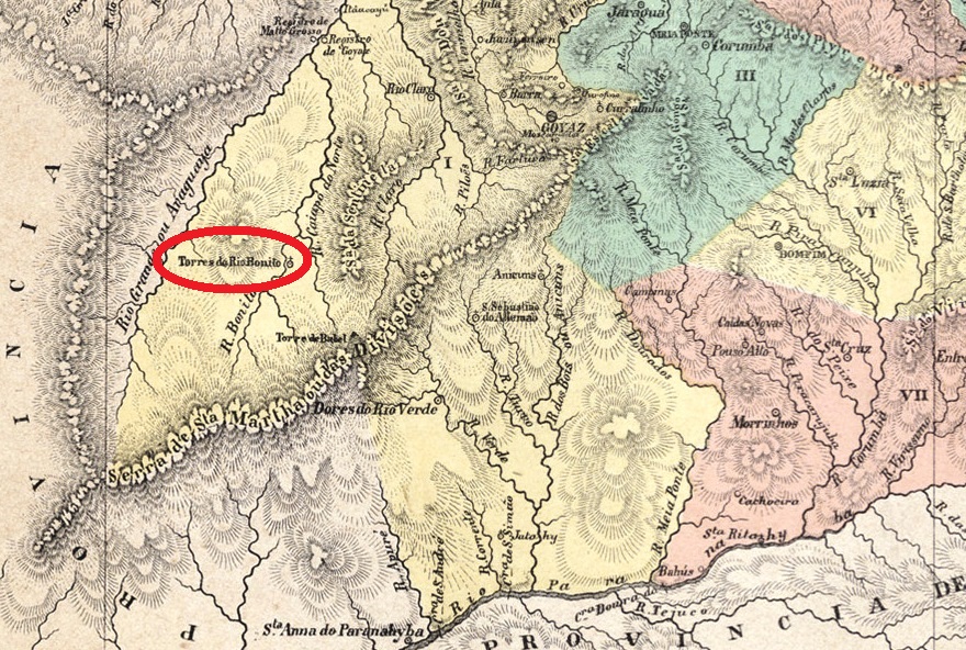
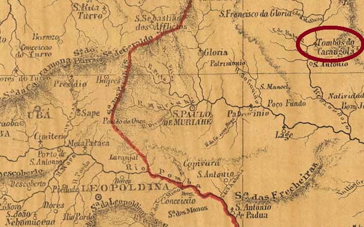
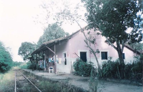
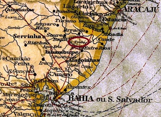
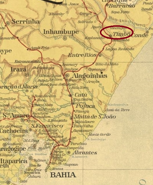
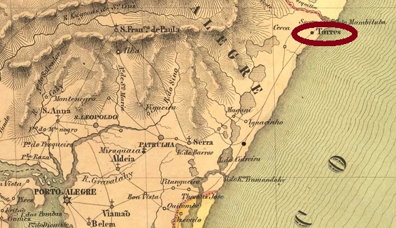
The most glamorous seaside resort in the southern state of Rio Grande do Sul was originally intended as a prison. Anyway, a presídio is often mentioned in the regional press in the early 19th century. The district of São Domingos das Torres came into being in December 1832 at Conceição do Arroio (today Osório) and was located barely 200 km northeast of the provincial capital Porto Alegre, on the provincial border with Santa Catarina. In May 1878, the village was promoted to Villa, then downgraded again as a district of Conceição do Arroio in December 1887, only to regain administrative autonomy as a municipio in January 1890.

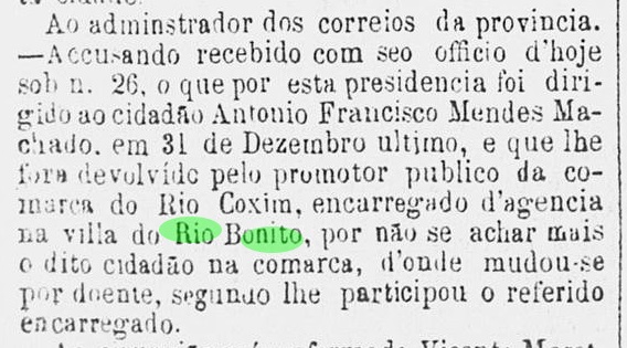
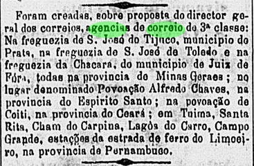
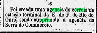
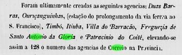
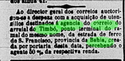
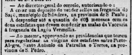
Two foundation dates for the local post office have been found, but there may be a third. First in August 1816, as Nova Monteiro writes in Administrações e Agencias Postaes do Brasil Imperio (in Brasil Filatelico/RJ, 1934-5; reprint SPP 1994-1999). Then in 1866, as stated in the Directory of Imperial Post Offices (Tabella das Agencias do Correio do Imperio, Rio de Janeiro, 1885). Although the place was not listed in the Postal Guide (Guia do Correio do Brasil) of 1857, there was at least a mail relay service in the early 1860s, as reported by the Rio press:

Jornal do Commercio/RJ, 12.02.1860

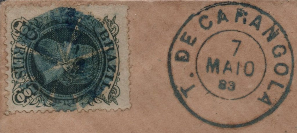
So far, only one postmark of this locality was found towards the end of the Empire. TRS-0455c (Coll. José A. Junges) is a plain double circle – which also exists in red and purple – with the inscription TORRES at the top. The dates inside go from 1883 to 1920.

John Arrowsmith: Map of Brazil, 1844

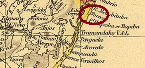
Der glamouröseste Badeort im südlichen Bundesstaat Rio Grande do Sul war ursprünglich als Gefängnis bestimmt. Jedenfalls wird ein Presídio oft in der Regionalpresse im frühem 19 Jahrhundert erwähnt. Wie es dem auch sei, der Distrikt von São Domingos das Torres entstand im Dezember 1832 bei Conceição do Arroio (heute Osório) und lag knapp 200 km nordöstlich der Provinzhauptstadt Porto Alegre entfernt, an der Provinzgrenze zu Santa Catarina. Im Mai 1878 stieg der Ort zu Villa auf, dann wurde er im Dezember 1887 wieder als Distrikt von Conceição do Arroio herabgestuft, um im Januar 1890 die Verwaltungsautonomie als Municipio wieder zu erlangen.

Es wurden zwei Gründungsdaten fürs örtliche Postamt gefunden, aber möglicherweise gibt es ein drittes. Zuerst im August 1816, wie Nova Monteiro im Administrações e Agencias Postaes do Brasil Imperio (in Brasil Filatelico/RJ, 1934-5; Reprint SPP 1994-1999) schreibt. Dann 1866, wie im Verzeichnis der kaiserlichen Postämter (Tabella das Agencias do Correio do Imperio, Rio de Janeiro, 1885) zu lesen ist. Obwohl der Ort nicht im Postführer (Guia do Correio do Brasil) von 1857 aufgelistet war, gab es zumindest einen Poststafettendienst Anfang 1860, wie die Presse aus Rio berichtet:

Jornal do Commercio/RJ, 12.02.1860

Bisher war nur ein Poststempel dieser Ortschaft gegen Ende des Kaiserreichs zu finden. TRS-0455c (Samml. José A. Junges) ist ein schlichter Doppelkreis – den es auch in Rot und Lila gibt – mit der Inschrift TORRES oben. Die Daten im Inneren gehen von 1883 bis 1920.

Categories
Carimbologia T-Z

Torres do Rio Bonito, Goiás (TGO-0275)

Atlas do Imperio do Brasil, 1868

Other names: Rio Bonito, Caiapônia (1943)

See also Rio Bonito (RGO-0170)

Torres do Rio Bonito was the name of a district established in 1855 in the municipality of Rio Verde on the south bank of th Rio Bonito, 290 km southwest of the provincial capital Goyaz (today Goiás Velho) province. After the foundation, the locality near the main trail between the towns of Goiás and Cuiabá flourished slowly. In 1873 it emancipated from Rio Verde as the Vila do Espírito Santo de Torres do Rio Bonito, and in 1943 it became the municipality of Caiapônia, a name derivated from the Caiapó (former Cayapo do Norte) River, which flows through the region.

The 1885 Imperial Mail Register (Tabella das Agencias do Correio do Império) lists the postal agency with creation date of 1879, but this was probably a reopening, for already in June 1876 a Rio Bonito post office was mentioned in the regional press:

Correio Official de Goyaz, June 24, 1876

No postal cancellation from the Empire period has been found to date. Given that around 1880 the local population consisted of ca. 1,000 inhabitants – most of them illiterate – stamps with imperial cancel dates must be very rare.

Provincia de Goyaz, 1875

Andere Namen: Torres do Rio Bonito, Caiapônia (1943)

Siehe auch Rio Bonito (RGO-0170)

Torres do Rio Bonito hieß ein im Jahr 1855 gegründeter Distrikt des Bezirks Rio Verde am Südufer des Rio Bonito, 290 km südwestlich der Provinzhauptstadt Goyaz (heute Goiás Velho). Die Ortschaft lag etwa außerhalb der Urwaldroute zwischen den Provinzhauptstädten Goiás und Cuiabá und wuchs eher langsam. In 1873 erlang sie den Status einer Villa – und dazu die Verwaltungsautonomie – unter dem Namen Espírito Santo de Torres do Rio Bonito, und in 1943 wurde der Município in Caiapônia umbenannt. Die etwas seltsam anmutende Bezeichnung kommt von Caiapó (damals: Cayapo do Norte), einem Fluss der Gegend.

Im Verzeichnis der kaiserlichen Postämter (Tabella das Agencias do Correio do Império) von 1885 wird die örtliche Poststelle mit Entstehungsjahr 1879 angegeben. Es dürfte sich hier um eine Wiedereröffnung handeln, da schon in 1876 das Postamt in Rio Bonito in der Regionalpresse Erwähnung fand:

Correio Official de Goyaz, 24. Juni 1876

Bisher wurde kein Poststempel aus der Kaiserzeit gefunden. Diese dürfte auch sehr selten sein, wenn man erfährt, dass um 1880 die Einwohnerzahl des Ortes ca. 1.000 Seelen betrug, die allermeisten davon auch Analphabeten.

Categories
Carimbologia T-Z

Tombos do Carangola, Minas Gerais (TMG-3205)

Atlas do Imperio do Brasil, 1868

Another name: Tombos (1923)

A tombo in Portuguese is a fall. Here a waterfall is probably meant, as the Freguesia of Nossa Senhora da Conceição dos Tombos (Our Lady of the Immaculate Conception at the Falls) was founded in May 1852 on the east bank of the Carangola River in the Município of Presídio de Ubá, 270 km southeast of the provincial capital Ouro Preto. A year later, the place changed as a district of Ubá, then again in May 1855 to the Município of S. Paulo de Muriahe, then in November 1878 to the Município of Carangola. Tombos has been an independent município since September 1923.

As Paula Sobrinho writes in História Postal de Minas Gerais (Belo Horizonte, 1997), there was a post office there since November 1870. Two postmarks in a double circle, one mute and one handwritten cancellation were found for the Empire. TMG-3205a (Coll. José A. Junges) has the inscription T. DE CARANGOLA on top, the dates inside go from 1880 to 1886. TMG- 3205b (Coll. José A. Junges) now has the inscription TOMBOS DO CARANGOLA on top; below is an ornament in rhombus. The internal dates go from 1886 to 1900.

Both the mute and the handwritten cancellation also come from the J.A. Junges collection. The former was in circulation at least 1882-1883, in connection with TMG-3205a:

1882-1883 (JJ)

The handwritten cancellation was used between 1884 and 1885:

1884-1885 (JJ)
Provincia de Minas Geraes, 1873

Anderer Name: Tombos (1923)

Ein tombo ist auf Portugiesisch ein Fall. Hier ist wohl ein Wasserfall gemeint, da die Freguesia von Nossa Senhora da Conceição dos Tombos (Unsere Liebe Frau des Unbefleckten Empfängnis an den Fällen) im Mai 1852 am Ostufer des Flusses Carangola im Município von Presídio de Ubá gegründet wurde, 270 km südöstlich der Provinzhauptstadt Ouro Preto entfernt. Ein Jahr später wechselte der Ort als Distrikt von Ubá, dann wieder im Mai 1855 zum Município von S. Paulo de Muriahe, danach im November 1878 zum Município von Carangola. Seit September 1923 ist Tombos ein eigenständiger Município.

Wie Paula Sobrinho in História Postal de Minas Gerais (Belo Horizonte, 1997) schreibt, gab es dort ein Postamt seit November 1870. Zwei Poststempel im Doppelkreis, eine stumme und eine handschriftliche Entwertung waren fürs Kaiserreich zu finden. TMG-3205a (Samml. José A. Junges) hat oben die Inschrift T. DE CARANGOLA, die Daten im Inneren gehen von 1880 bis 1886. TMG- 3205b (Samml. José A. Junges) hat nun die Inschrift TOMBOS DO CARANGOLA oben; unten ist ein Ornament in Raute. Die inneren Daten gehen von 1886 bis 1900.

Sowohl die stumme als auch die handschriftliche Entwertung entstammen ebenfalls aus der J.A. Junges-Sammlung. Erstere war zumindest 1882-1883 im Umlauf, in Verbinduing mit TMG-3205a:

1882-1883 (JJ)

Die handschriftliche Entwertung war bisher zwischen 1884 und 1885 zu finden:

1884-1885 (JJ)

Categories
Carimbologia T-Z

Todos os Santos (train station/Bahnhof), Municipio Neutro (TMN-2265)

Almanak Laemmert, 1892

Todos os Santos (All Saints) station was inaugurated in 1868 by the E.F. Dom Pedro II railway company on the Central Line and was located about 13 km west of the centre of Rio de Janeiro. From 1889 until its closure around 1970, the line operator was the E.F. Central do Brasil. Today, only ruins remain from the old station:

ca. 1910 (Photo: Felipe Ribeiro, in estacoesferroviarias.com.br)
2009 (photo: Julio Cesar Silva, in estacoesferroviarias.com.br)

The station post office was created in 1870, according to the Directory of Imperial Post Offices (Tabella das Agencias do Correio do Imperio, Rio de Janeiro, 1885). Two postmarks in double circle from the imperial period are known. TMN-2265a (Coll. Dieter Kerkhoff) has the inscription TODOS OS SANTOS at the top. The only specimen so far has a date from 1885 in the centre. TMN-2265b (Coll. José A. Junges) has the same inscription at the top, but here the letters are a little more elongated, and at the bottom there is another ornament in lozenge, formed by four small lozenges. Dates in the middle: ca. 1883 to 1890.

Linhas Ferroviarias do Distrito Federal, 1907

Der Bahnhof Todos os Santos (Allerheiligen) wurde 1868 durch die E.F. Dom Pedro II Bahngesellschaft auf der Zentrum-Linie eingeweiht und lag ca. 13 km westlich der Stadtmitte von Rio de Janeiro entfernt. Von 1889 bis zur Stilllegung um 1970 hieß der Linienbetreiber E.F. Central do Brasil. Heute sind nur noch Ruinen aus der alten Station übrig geblieben:

ca. 1910 (Foto: Felipe Ribeiro, in estacoesferroviarias.com.br)
2009 (Foto: Julio Cesar Silva, in estacoesferroviarias.com.br)

Das Bahnhofspostamt entstand 1870, wie das Verzeichnis der kaiserlichen Postämter (Tabella das Agencias do Correio do Imperio, Rio de Janeiro, 1885) schreibt. Zwei Poststempel in Doppelkreis aus der Kaiserzeit sind bekannt. TMN-2265a (Samml. Dieter Kerkhoff) hat die Inschrift TODOS OS SANTOS oben. Das bisher einzige Exemplar hat ein Datum aus 1885 in der Mitte. TMN-2265b (Samml. José A. Junges) hat die gleiche Inschrift oben, allerdings sind hier die Buchstaben etwas länglicher, und unten ist noch ein Ornament in Raute, das aus vier kleinen Rauten gebildet wird. Daten in der Mitte: ca. 1883 bis 1890.

Categories
Carimbologia T-Z

Tocantins (train station/Bahnhof), Minas Gerais (TMG-3200)

Estado de Minas Geraes, 1910

See also São José de Tocantins (SMG-2435)

Tocantins railway station was inaugurated in July 1886 by the E.F. Leopoldina Railway Company and was located on the Caratinga Line in the district of São José de Tocantins, Município of Ubá, about 200 km southeast of the provincial capital Ouro Preto. The settlement around the railway station continued to grow and was elevated to the Município of Tocantins in December 1948. The railway line became Rede Ferroviária Federal S.A. in 1975 until its closure in 1994 (estacoesferroviarias.com.br). The station building is now used as housing.

in 1957 (Photo: Milton Palhares, in estacoesferroviarias.com.br)

The station post office was built shortly before the end of the Empire, in November 1889, as shown in the postal report (Boletim Postal) of the following month:

Boletim Postal No.8 (December 1889)

The postmark is TMG-3200a (Coll. José A. Junges): a double circle with the inscriptions TOCANTINS above and (MINAS) below. A specimen sighted, with a date from 1896 in its centre. For local stamps of S. José de Tocantins, see SMG-2435.

Estrada de Ferro Leopoldina

Siehe auch São José de Tocantins (SMG-2435)

Der Bahnhof Tocantins wurde im Juli 1886 durch die E.F. Leopoldina Bahngesellschaft eingeweiht und lag auf der Caratinga-Linie im Distrikt von São José de Tocantins, Município von Ubá, ca. 200 km südöstlich der Provinzhauptstadt Ouro Preto entfernt. Die Siedlung um den Bahnhof wuchs weiter und wurde im Dezember 1948 zum Município von Tocantins erhoben. Die Bahnlinie ging 1975 bis zur Stilllegung 1994 zur Rede Ferroviária Federal S.A. (estacoesferroviarias.com.br). Das Bahnhofsgebäude dient heute als Wohnraum.

1957 (Foto: Milton Palhares, in estacoesferroviarias.com.br)

Das Bahnhofspostamt entstand kurz vor dem Ende des Kaiserreichs, im November 1889, wie aus dem Postbericht (Boletim Postal) des folgenden Monats hervorgeht:

Boletim Postal Nr.8 (Dezember 1889)

Der Poststempel ist TMG-3200a (Samml. José A. Junges): ein Doppelkreis mit den Inschriften TOCANTINS oben und (MINAS) unten. Ein Exemplar gesichtet, mit einem Datum aus 1896 in seiner Mitte. Für Ortsstempel von S. José de Tocantins siehe SMG-2435.

Categories
Carimbologia T-Z

Tiuma (train station/Bahnhof), Pernambuco (TPE-0645)

Rede Ferroviaria de Pernambuco 1898 (IBGE)

Tiuma station was inaugurated in October 1881 by the Great Western Railway Company, Northern Line, and was in the Município of São Lourenço da Mata, 30 km west of the provincial capital Recife. In 1950, the railway line became the property of Rede Ferroviária do Nordeste, and from 1975 until its closure in 1996, it belonged to Rede Ferroviária Federal S. A. (estacoesferroviarias.com.br). Today, the former station house is to be used as a residential building:

ca. 2009 (Photo: Sidney Correia, in estacoesferroviarias.com.br)

The station post office was created in October 1882, according to the Rio press:

O Globo/RJ, 28.10.1882

The oldest postmark so far is TPE-0645a (Coll. Ginaldo Bezerra da Silva): a double circle with the inscriptions TIUMA at the top and (PERNAMBUCO) at the bottom. The dates in the centre go from 1891 to at least 1894.

IBGE (in estacoesferroviarias.com.br)

Der Bahnhof Tiuma wurde im Oktober 1881 durch die Great Western Eisenbahngesellschaft, Nordlinie, eingeweiht und lag im Município von São Lourenço da Mata, 30 km westlich der Provinzhauptstadt Recife entfernt. 1950 ging die Bahnlinie in Besitz der rede Ferroviária do Nordeste, und von 1975 bis zur Stilllegung 1996 gehörte sie der Rede Ferroviária Federal S. A. (estacoesferroviarias.com.br). Heute soll das ehemalige Bahnhofsgebäude als Wohnhaus dienen:

ca. 2009 (Foto: Sidney Correia, in estacoesferroviarias.com.br)

Das Bahnhofspostamt entstand im Oktober 1882, wie die Rio-Presse mitteilt:

O Globo/RJ, 28.10.1882

Das bisher älteste Poststempel ist TPE-0645a (Samml. Ginaldo Bezerra da Silva): ein Doppelkreis mit den Inschriften TIUMA oben und (PERNAMBUCO) unten. Die Daten in der Mitte gehen von 1891 bis mindestens 1894.

Categories
Carimbologia T-Z

Tinguá (train station/Bahnhof), Rio de Janeiro (TRJ-1906)

Estrada de Ferro Central do Brasil, 1890

See also Serra do Commercio (SRJ-1585)

Tinguá station was inaugurated in 1883 by the E.F. do Rio d’Ouro railway company, Tinguá branch, in the Município of Nova Iguassú and was located 60 km northwest of the capital Rio de Janeiro. The railway line belonged to the E.F. Central do Brasil from 1928 until its closure. Today, Tinguá is a suburb of Nova Iguaçu.

The station post office was created in July 1886, in succession to the Serra do Commercio post office, according to the Rio press:

Diario de Noticias, 17.07.1886

Paulo Novaes writes down a date from October of that year for this in agenciaspostais.com.br, but this would be the date when the post office was put into operation. So far, no imperial postmark from this station has appeared.

Almanak Laemmert, 1892

Siehe auch Serra do Commercio (SRJ-1585)

Der Bahnhof Tinguá wurde 1883 durch die E.F. do Rio d’Ouro Bahngesellschaft, Tinguá-Abzweigung, im Município von Nova Iguassú eingeweiht und lag 60 km nordwestlich der Hauptstadt Rio de Janeiro entfernt. Die Bahnlinie gehörte von 1928 bis zur Stilllegung zur E.F. Central do Brasil. Heute ist Tinguá ein Vorort der Stadt Nova Iguaçu.

Das Bahnhofspostamt entstand im Juli 1886, in der Nachfolge des Postamts Serra do Commercio, wie aus der Rio-Presse hervorgeht:

Diario de Noticias, 17.07.1886

Paulo Novaes schreibt dafür in agenciaspostais.com.br ein Datum aus Oktober des Jahres auf, das dürfte aber der Zeitpunkt der Inbetriebnahme des Postamts sein. Bisher ist kein kaiserlicher Poststempel aus diesem Bahnhof aufgetaucht.

Categories
Carimbologia T-Z

Timbó-Assú (train station/Bahnhof), Pernambuco (TPE-0640)

Carta Corographica da Provincia de Pernambuco, 1880

Timbó-Assú station was built in November 1860 in the fazenda of the same name near Escada by the E.F. do Recife ao São Francisco railway company (Southern line) and was located over 50 km southwest of Recife. The railway line went to the Great Western in 1901, to the Rede Ferroviaria do Nordeste in 1950 and to the Rede Ferroviária Federal S. A. from 1975 until its closure in 1996 (estacoesferroviarias.com.br). The station building has already been dismantled, only traces of the old railway line remain in the middle of the sugar cane plantation.

In 2019 (Photo: Sydney Correa, in estacoesferroviarias.com.br)

There was a railway station post office there from 1864, as the Directory of Imperial Post Offices (Tabella das Agencias do Correio do Imperio, Rio de Janeiro, 1885) tells us. Only one 19th century postmark has been found so far, probably not the oldest. TPE-0640b (Coll. José A. Junges) is a double circle with the inscriptions EST. DE TIMBÓ-ASSÚ above and (PERNAMo) below. The only specimen bears a date of 1891 in the centre.

Arthur D. Ribeiro: Estado de Pernambuco, 1924

Der Bahnhof Timbó-Assú wurde im November 1860 in der gleichnamigen Fazenda bei Escada durch die E.F. do Recife ao São Francisco Bahngesellschaft (Südlinie) gebaut und lag über 50 km südwestlich von Recife. Die Bahnlinie ging 1901 an die Great Western, 1950 an die Rede Ferroviária do Nordeste und von 1975 bis zur Stilllegung 1996 an die Rede Ferroviária Federal S. A. (estacoesferroviarias.com.br). Das Bahnhofsgebäude wurde bereits abgebaut, nur Spuren der alten Bahnlinie sind mitten in der Zuckerrohrplantage noch vorhanden.

2019 (Foto: Sydney Correa, in estacoesferroviarias.com.br)

Es gab dort ein Bahnhofspostamt ab 1864, wie uns das Verzeichnis der kaiserlichen Postämter (Tabella das Agencias do Correio do Imperio, Rio de Janeiro, 1885) verrät. Nur ein Poststempel des 19. Jahrhunderts wurde bisher gefunden, wohl nicht der älteste. TPE-0640b (Samml. José A. Junges) ist ein Doppelkreis mit den Inschriften EST. DE TIMBÓ-ASSÚ oben und (PERNAMo) unten. Das einzige Exemplar trägt in der Mitte ein Datum aus 1891.

Categories
Carimbologia T-Z

Timbó (TBA-0735) – Timbó (train station/Bahnhof), Bahia (TBA-0736)

Mappa Geral do Brasil, 1910

Text update of May 24, 2022

Timbó is the generic Indian name for many liana varieties in Brazil, which were used as anaesthetics for fishing due to their toxic ingredients:

Derris ellipitica (Photo: Kim & Forest Sparr, CC-BY 3.0)

The Arraial of Timbó was a small settlement that emerged around 1850 and was located in the Município of Vila do Conde, over 160 km north of the provincial capital Salvador da Bahia. After the construction of the E.F. da Bahia ao São Francisco railway company towards the end of the Empire, the village grew rapidly, as it was initially located at the end of the rail line. However, with the decline of the railway, it soon shrank again and is now a suburb in the Município of Esplanada.

The local post office was established around the turn of the year 1876-77, according to the provincial president’s report for 1877:

Relatorio do Presidente da Provincia/BA 1877

The railway station, inaugurated at the end of March 1887, probably caused a move of the postal agency from the centre of the village to the rails, as can be deduced from a Rio press release:

Gazeta da Tarde/RJ, 31/03/1887

Three early postmarks were found, all with dates from the Republic. TBA-0735a (Coll. Luis C. Fritzen) is a plain double circle with the inscription TIMBÓ at the top. One copy was seen, dated 1890 in the centre. TBA-0736a (Coll.. FM) is a rectangular box stamp for ambulant mail, with the inscription AMB. TIMBÓ, found on stamps of the Southern Cross issue (1890ff). TBA-0735b (image from the Internet) is a double circle with the inscriptions TIMBÓ above and (BAHIA) below. The only specimen so far bears a date from 1902 in the centre.

Estado da Bahia, 1913

Textaktualisierung vom 24.05.2022

Timbó ist der allgemeine indianische Name für viele Lianensorten in Brasilien, die durch ihre giftigen Inhaltsstoffe als Betäubungsmittel für Fische verwendet wurden:

Derris ellipitica (Foto: Kim & Forest Sparr, CC-BY 3.0)

Der Arraial von Timbó war eine kleine Siedlung, die um 1850 entstanden ist und im Município von Vila do Conde lag, über 160 km nördlich von der Provinzhauptstadt Salvador da Bahia entfernt. Nach dem Bau der E.F. da Bahia ao São Francisco Eisenbahngesellschaft gegen Ende des Kaiserreichs wuchs der Ort schnell, da er zunächst am Ende der Bahnstrecke lag. Mit dem Niedergang des Bahnbetriebs schrumpfte er aber auch bald wieder und ist heute ein Vorort im Município von Esplanada.

Das örtliche Postamt wurde um die Jahreswende 1876-77 ins Leben gerufen, wie der Bericht des Provinzpräsidenten für 1877 mitteilt:

Relatorio do Presidente da Provincia/BA 1877

Der am Ende März 1887 eingeweihte Bahnhof verursachte wohl einen Umzug der Postagentur aus der Ortsmitte zu den Schienen, wie man aus der Rio-Presse entnehmen kann:

Gazeta da Tarde/RJ, 31.03.1887

Drei frühe Poststempel wurden gefunden, alle mit Daten aus der Republik. TBA-0735a (Samml. Luis C. Fritzen) ist ein schlichter Doppelkreis mit der Inschrift TIMBÓ oben. Ein Exemplar gesehen, datiert 1890 in der Mitte. TBA-0736a (Samml. FM) ist ein rechteckiger Kastenstempel für den ambulanten Postbetrieb, mit der Inschrift AMB. TIMBÓ, gefunden auf Marken der Ausgabe Kreuz des Südens (1890ff). TBA-0735b (Abb. aus dem Internet) ist ein Doppelkreis mit den Inschriften TIMBÓ oben und (BAHIA) unten. Das bisher einzige Exemplar trägt ein Datum aus 1902 in der Mitte.

Categories
Carimbologia T-Z

Timbauba, Pernambuco (TPE-0635)

Carta Corographica da Provincia de Pernambuco, 1880

Timbauba (now spelled Timbaúba) was a district in the Município of Itambé from May 1853, located about 100 km northwest of the provincial capital Recife. In April 1879 it received administrative autonomy as a vila and has been a town since June 1884. The name refers to a plant of the Fabaceae family (Stryphnodendrum sp./Mart.):

Stryphnodendrum adstringens (Photo: Eurico Zimbres, CC-BY-SA 3.0)

The Directory of Imperial Post Offices (Tabella das Agencias do Correio do Imperio, Rio de Janeiro, 1885) lists the local post office as of 1873. However, postal operations did not start until July of the following year, according to the Pernambuco press:

Diario de Pernambuco, 16.07.1874

The imperial postal cancel is the French type TPE-0635a (Coll. José A. Junges): a small double circle, also available in lilac, with the inscription TIMBAUBA at the top and the small star between brackets at the bottom. The dates in the middle have been found so far for the period between about 1883 and at least 1891.

Atlas do Imperio do Brasil, 1868

Timbauba (heute Timbaúba geschrieben) war ab Mai 1853 ein Distrikt im Município von Itambé, der ca. 100 km nordwestlich der Provinzhauptstadt Recife entfernt lag. Im April 1879 erhielt der Ort die Verwaltungsautonomie als Vila und ist eine Stadt seit Juni 1884. Der Name bezeichnet eine Pflanze der Familie Fabaceae (Stryphnodendrum sp./Mart.):

Stryphnodendrum adstringens (Foto: Eurico Zimbres, CC-BY-SA 3.0)

Das Verzeichnis der kaiserlichen Postämter (Tabella das Agencias do Correio do Imperio, Rio de Janeiro, 1885) listet das örtliche Postamt ab 1873 auf. Allerdings startete der Postbetrieb erst im Juli des folgenden Jahres, wie die Presse aus Pernambuco berichtet:

Diario de Pernambuco, 16.07.1874

Der kaiserliche Posttempel ist der Französiche Typus TPE-0635a (Samml. José A. Junges): ein kleiner Doppelkreis, den es auch in lila gibt, mit der Inschrift TIMBAUBA oben und dem kleinen Stern zwischen Klammern unten. Die Daten in der Mitte wurden bisher für den Zeitraum zwischen ca. 1883 und mindestens 1891 gefunden.