Categories
Carimbologia T-Z

Volta Redonda (train station/Bahnhof), Rio de Janeiro (VRJ-1730)

Estações do Rio de Janeiro, São Paulo e Minas Geraes, 1880

Text update of June 2, 2024

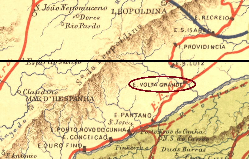
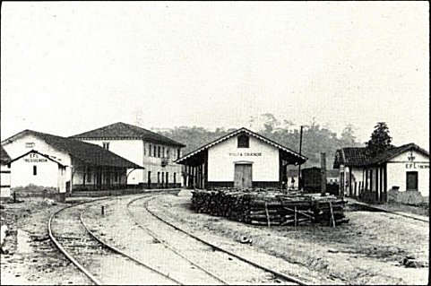
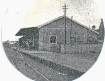
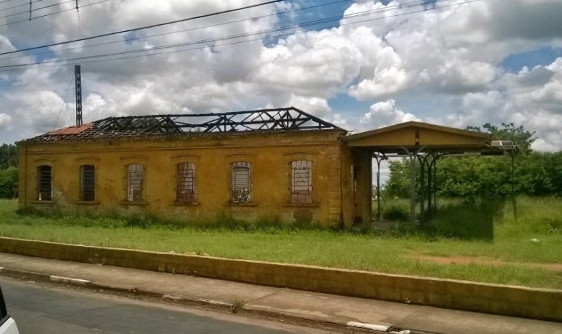
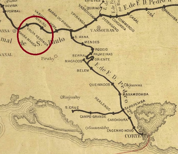
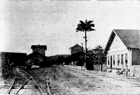
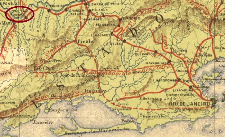
Volta Redonda (Round Arch, here referring to the Parahyba do Sul River) station was inaugurated in September 1871 by the E.F. Dom Pedro II (São Paulo Line) in the município of Barra Mansa and was located on the south bank of the Parahyba do Sul River, 130 km northwest of the capital Rio de Janeiro. The railway line went to E.F. Central do Brasil after 1889, and from 1975 until its closure in 1996 it belonged to Rede Ferroviária Federal S.A. The station building has long since been demolished (estacoesferroviarias.com.br).

Photo: Revista da Semana 6.8.1905 (in estacoesferroviarias.com.br)

Around the station, the settlement continued to grow, becoming a district in December 1890 and an independent município in July1954.

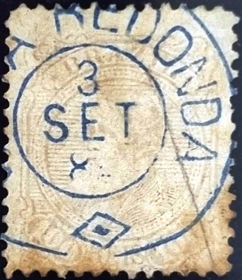
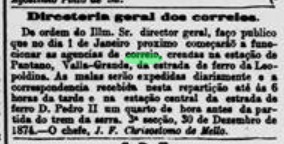
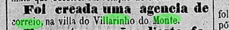
According to the Imperial Post Office Directory (Tabella das Agencias do Correio do Imperio, Rio de Janeiro, 1885), there was a post office in the station from 1871. Four postmarks were found for the 19th century. VRJ-1730a (Coll. Paulo Comelli) is an ellipse with the inscription EST(AÇÃO)/VOLTA RE(DONDA). The only known example is purple and was used on a D. Pedro issue of 1866. VRJ-1730b (agenciaspostais.com.br) is a double circle with the inscription VOLTA REDONDA at the top. Again, only one example exists, dated 1877 in the centre. Its successor VRJ-1730c (Coll. Dieter Kerkhoff) is similar, but has an ornament in lozenge at the bottom. Here there is also only one example, now from 1889. Finally, VRJ-1730d (image from the internet) is also a double circle with the same inscription at the top. Below one reads here (EST.), and the dates inside go from 1889 to at least 1894.

In the meantime, another postmark from Volta Redonda has turned up: VRJ-1730e (Coll. Marcio Duarte) should fit chronologically between VRJ-1730b and VRJ-1730c:

VRJ-1730e (MD) 1883ff-1885, also in blue
E.F. Central do Brasil, 1890

Textaktualisierung am 2. Juni 2024

Der Bahnhof Volta Redonda (Runder Bogen, hier ist der Fluss Parahyba do Sul gemeint) wurde im September 1871 durch die E.F. Dom Pedro II (São Paulo-Abzweigung) im Município von Barra Mansa eingeweiht und lag am Südufer des Flusses Parahyba do Sul, 130 km nordwestlich der Hauptstadt Rio de Janeiro. Die Bahnlinie ging nach 1889 zur E.F. Central do Brasil und von 1975 bis zur Stilllegung 1996 gehörte sie der Rede Ferroviária Federal S.A. Das Bahnhofsgebäude wurde längst abgerissen (estacoesferroviarias.com.br).

Foto: Revista da Semana 6.8.1905 (in estacoesferroviarias.com.br)

Rund um den Bahnhof wuchs die Siedlung weiter, sie wurde im Dezember 1890 zum Distrikt und im Juli 1954 zum selbständigen Município.

Wie im Verzeichnis der kaiserlichen Postämter (Tabella das Agencias do Correio do Imperio, Rio de Janeiro, 1885) zu lesen ist, gab es im Bahnhof ein Postamt ab 1871. Vier Poststempel wurden fürs 19. Jahrhundert gefunden. VRJ-1730a (Samml. Paulo Comelli) ist eine Ellipse mit der Inschrift EST(AÇÃO)/VOLTA RE(DONDA). Das einzig bekannte Exemplar hat die Farbe lila und wurde auf eine D. Pedro Ausgabe aus 1866 verwendet. VRJ-1730b (agenciaspostais.com.br) ist ein Doppelkreis mit der Inschrift VOLTA REDONDA oben. Auch hier nur ein Exemplar vorhanden, datiert 1877 in der Mitte. Sein Nachfolger VRJ-1730c (Samml. Dieter Kerkhoff) ist ihm ähnlich, hat aber ein Ornament in Raute unten dazu. Auch nur ein Exemplar, diesmal aus 1889. Schließlich, VRJ-1730d (Abb. aus dem Internet) ist auch ein Doppelkreis mit gleicher Inschrift oben. Unten liest man hier (EST.), und die Daten im Inneren gehen von 1889 bis mindestens 1894.

Inzwischen ist ein weiterer Poststempel aus Volta Redonda aufgetaucht: VRJ-1730e (Samml. Marcio Duarte) dürfte chronologisch zwischen VRJ-1730b und VRJ-1730c passen:

VRJ-1730e (MD) 1883ff-1885, auch in blau
Categories
Carimbologia T-Z

Volta Grande (train station/Bahnhof), Minas Gerais (VMG-3320)

E.F. Central do Brasil, 1890

Other names: Valla Grande, Volta Grande de Além Parahyba

The Volta Grande railway station was inaugurated in August 1874 by the Estrada de Ferro Leopoldina in the município of Mar d’Hespanha, located on the south bank of the Angu River, 300 km south of the provincial capital Ouro Preto. The railway line belonged to Rede Ferroviária Federal S.A. from 1975 until its closure in 1996. Today, the station building serves as accommodation for railway employees (estacoesferroviarias.com.br).

Ca. 1940 (Photo: Preserve)
Photo: Decio Marques, 2021 (estacoesferroviarias.com.br):

Around the station, the settlement continued to grow and became a district in the município of Além-Parahyba in March 1891. Volta Grande has been an independent município since December 1938.

Three years of origin for the station post office were found. The first one was around December 1874, according to the Rio press. However, the station is here called Valla Grande:

Jornal do Commercio/RJ, 30.12.1874

The second post office opening is said to have taken place in 1878, as listed in the Directory of Imperial Post Offices (Tabella das Agencias do Correio do Imperio, Rio de Janeiro, 1885). Finally, Paula Sobrinho writes in História Postal de Minas Gerais (Belo Horizonte, 1997) that there was a post office there since July 1881.

Five town postmarks and two mute postmarks were found for the 19th century. VMG-3220a is probably the first among them. It was in use from the beginning until at least 1876 and was already presented by Paulo Ayres in Catálogo de Carimbos Brasil-Império, (S. Paulo, 1937, 1942) under no. 1538:

VMG-3220a (P.A.1538)

It was followed by the enigmatic VMG-3220b (Coll. José A. Junges): a three-liner with the inscription AGENCIA/DO CORREIO/DE VOLTA GRANDE, without frame or date. Then there came two stamps as double circles. VMG-3220c (Coll. José A. Junges) has only the inscription VOLTA GRANDE at the top, with internal dates from 1884 to 1886. VMG-3220d (Coll. José A. Junges) has now the inscription (EST.) at the bottom, with dates in the middle from 1884 to 1893. VMG-3220e (Coll. Márcio Protzner) is a beautiful negative-look postmark:

VMG-3220e (MP) 1894ff-1901

The two mute cancellations are listed in Mute Cancellations of the Brazil Empire / Carimbos Mudos do Brasil Império (Brazil Philatelic Association, Rio de Janeiro, 2000) by J. Dingler and K.W. Lopes under nos. 285 and 1062. BPA 285 is also listed under Paulo Ayres (op. cit.) with no. 18:

BPA 285 (P.A. 18, 1874ff); 1062
Estações do Rio de Janeiro, São Paulo e Minas Geraes, 1880

Andere Namen: Valla Grande, Volta Grande de Além Parahyba

Der Bahnhof Volta Grande wurde im August 1874 durch die Estrada de Ferro Leopoldina im Município von Mar d’Hespanha eingeweiht und lag am Südufer des Flusses Angu, 300 km südlich der Provinzhauptstadt Ouro Preto entfernt. Die Bahnlinie gehörte von 1975 bis zur Stilllegung 1996 der Rede Ferroviária Federal S.A. (estacoesferroviarias.com.br). Heute dient das Bahnhofsgebäude als Unterkunft für Bahnmitarbeiter.

Ca. 1940 (Foto: Preserve)
Foto Decio Marques, 2021 (estacoesferroviarias.com.br)

Um den Bahnhof herum wuchs die Siedlung weiter und wurde im März 1891 ein Distrikt im Município vom Além-Parahyba. Seit Dezember 1938 ist Volta Grande ein selbständiger Município.

Drei Entstehungsjahre fürs Bahnhofspostamt wurden gefunden. Erstmals um Dezember 1874, wie aus der Presse aus Rio hervorgeht. Allerdings heißt der Bahnhof hier Valla Grande:

Jornal do Commercio/RJ, 30.12.1874

Die zweite Postamteröffnung soll 1878 stattgefunden haben, wie im Verzeichnis der kaiserlichen Postämter (Tabella das Agencias do Correio do Imperio, Rio de Janeiro, 1885) aufgelistet. Schließlich schreibt Paula Sobrinho in História Postal de Minas Gerais (Belo Horizonte, 1997), dass es dort seit Juli 1881 ein Postamt gab.

Fünf Ortsstempel und zwei stumme Stempel wurden für das 19. Jahrhundert gefunden. VMG-3220a ist wohl der erste darunter. Er war von Beginn an bis mindestens 1876 in Verwendung und wurde bereits durch Paulo Ayres in Catálogo de Carimbos Brasil-Império, (S. Paulo, 1937, 1942) unter Nr. 1538 vorgestellt:

VMG-3220a (P.A.1538)

Ihm folgte der rätselhafte VMG-3220b (Samml. José A. Junges): ein Dreizeiler mit der Inschrift AGENCIA/DO CORREIO/DE VOLTA GRANDE, ohne Rahmen oder Datumsangabe. Danach kamen zwei Stempel als Doppelkreise. VMG-3220c (Samml. José A. Junges) hat lediglich die Inschrift VOLTA GRANDE oben, mit inneren Daten von 1884 bis 1886. VMG-3220d (Samml. José A. Junges) hat nun dazu die Angabe (EST.) unten, mit Daten in der Mitte von 1884 bis 1893. VMG-3220e (Samml. Márcio Protzner) ist ein wunderschöner Poststempel in Negativ-Look:

VMG-3220e (MP) 1894ff-1901

Die zwei stummen Entwertungen sind in Mute Cancellations of the Brazil Empire/Carimbos Mudos do Brasil Império (Brazil Philatelic Association, Rio de Janeiro, 2000) von J. Dingler und K.W. Lopes unter den Nr. 285 und 1062 zu sehen. BPA 285 ist auch unter Paulo Ayres (op. cit.) mit Nr. 18 aufgelistet:

BPA 285 (P.A. 18, 1874ff); 1062

Categories
Carimbologia T-Z

Volta Grande (do Sapucahy), Minas Gerais (VMG-3325)

Atlas do Imperio do Brasil, 1868

The district of N. Sra. da Conceição da Volta Grande was founded in September 1881 in the município of S. Gonçalo do Sapucahy and was located on the east bank of the Sapucaí River, 400 km southwest of the provincial capital of Ouro Preto. In September 1923, the village changed its name to Careassú and became part of the new município of Santa Rita do Sapucaí. Since December 1953, Careaçu (as it is written today) has been an independent município. The name is of Indian origin and means Big River Curve.

As Paula Sobrinho writes in História Postal de Minas Gerais (Belo Horizonte, 1997), there has been a post office there since January 1889. However, this is said to have started its operation only in the Republic. So far, no postmark from the imperial period has been seen.

E. F. Central do Brasil, 1890

Anderer Name: Careassú (1923)

Der Distrikt von N. Sra. da Conceição da Volta Grande wurde im September 1881 im Município von S. Gonçalo do Sapucahy gegründet und lag am Ostufer des Flusses Sapucaí, 400 km südwestlich der Provinzhauptstadt Ouro Preto entfernt. Im September 1923 wechselte die Ortschaft unter dem Namen Careassú zum neu formierten Município von Santa Rita do Sapucaí. Seit Dezember 1953 ist Careaçu (wie es heute geschrieben wird) ein eigenständiger Município. Der Name ist indianischer Abstammung und bedeutet Großer Flussbogen.

Wie Paula Sobrinho in História Postal de Minas Gerais (Belo Horizonte, 1997) schreibt, gab es dort ein Postamt seit Januar 1889. Allerdings soll dies sein Betrieb erst in der Republik aufgenommen haben. Bisher war kein Poststempel der Kaiserzeit zu sehen.

Categories
Carimbologia T-Z

Vizeu, Pará (VPA-0255)

Villiers de l’Ile Adam: Carta (…) das Provincias do Grampará e Alto Amazonas, 1850

The freguesia of N. Sra. da Conceição de Vizeu was founded in 1758 in the area of the Vila of Bragança, on the west bank of the river Gurupi, 340 km east of the later provincial capital of Belém do Pará. It was elevated to a vila in December 1856 and to a town in July 1895.

As Nova Monteiro writes in Administrações e Agencias Postaes do Brasil Imperio (Brasil Filatelico/RJ, 1934-5; Reprint SPP 1994-1999) there was a post office there since July 1860. Only one local postmark has been found, unfortunately not the oldest: VPA-0255b (Coll. José A. Junges) is a French type: a double circle with the inscription VIZEU above and the typical star between brackets below. The only specimen seen so far bears a date of 1887 inside.

Atlas do Imperio do Brasil, 1868

Die Freguesia von N. Sra. da Conceição de Vizeu wurde 1758 im Gebiet der Vila von Bragança gegründet, am Westufer des Flusses Gurupi, 340 km östlich der späteren Provinzhauptstadt Belém do Pará entfernt. Sie wurde im Dezember 1856 zu einer Vila und im Juli 1895 zu einer Stadt erhoben.

Wie Nova Monteiro in Administrações e Agencias Postaes do Brasil Imperio (Brasil Filatelico/RJ, 1934-5; Reprint SPP 1994-1999) schreibt, gab es dort ein Postamt seit Juli 1860. Nur ein Poststempel des Orts wurde gefunden, leider nicht der älteste: VPA-0255b (Samml. José A. Junges) ist ein Französischer Typ: ein Doppelkreis mit der Inschrift VIZEU oben und dem typischen Stern zwischen Klammeren unten. Das einzig bisher besichtigte Exemplar trägt ein Datum aus 1887 im Inneren.

Categories
Carimbologia T-Z

Vista Alegre (train station/Bahnhof), Minas Gerais (VMG-3540)

Estações Ferroviarias do Rio de Janeiro, São Paulo e Minas Geraes, 1880

Vista Alegre station was inaugurated by the E.F. Leopoldina (Main Line) and was located on the west bank of the Rio Pomba in the município of Leopoldina, over 260 km southeast of the provincial capital Ouro Preto. From 1975 until its closure in 1996, the railway line belonged to Rede Ferroviária Federal S.A. (estacoesferroviarias.com.br). The former station was last used as a residential building:

In 2017 (Photo: Guilherme G. Lopes in estacoesferroviarias.com.br)

As can be read in the Directory of Imperial Post Offices (Tabella das Agencias do Correio do Imperio, Rio de Janeiro, 1885), there was a post office there from 1876. Two imperial postmarks were found. VMG-3540a also exists in blue, was used from the beginning until at least 1884 and was made known by Paulo Ayres (Catálogo de Carimbos Brasil-Império, S. Paulo, 1937, 1942) under No. 1537:

VMG-3540a (P.A. 1537)

It was followed by VMG-3540b (Coll. José A. Junges): a double circle with the inscriptions VISTA ALEGRE above and (EST.) below. It also exists in purple, and the dates inside go from 1887 to 1904.

E.F. Central do Brasil, 1890

Der Bahnhof Vista Alegre wurde durch die E.F. Leopoldina (Hauptlinie) eingeweiht und lag am Westufer des Rio Pomba im Município von Leopoldina, gut 260 km südöstlich der Provinzhauptstadt Ouro Preto entfernt. Von 1975 bis zu ihrer Stilllegung 1996 gehörte die Bahnlinie der Rede Ferroviária Federal S.A. (estacoesferroviarias.com.br). Das ehemalige Bahnhofsgebäude diente zuletzt als Wohnhaus:

Um 2017 (Foto: Guilherme G. Lopes in estacoesferroviarias.com.br)

Wie im Verzeichnis der kaiserlichen Postämter (Tabella das Agencias do Correio do Imperio, Rio de Janeiro, 1885) zu lesen ist, gab es dort ein Postamt ab 1876. Zwei kaiserliche Poststempel wurden gefunden. VMG-3540a gibt es auch in Blau, wurde vom Anfang an bis mindestens 1884 verwendet und ist uns durch Paulo Ayres (Catálogo de Carimbos Brasil-Império, S. Paulo, 1937, 1942) unter Nr. 1537 bekannt:

VMG-3540a (P.A. 1537)

Ihm folgte VMG-3540b (Samml. José A. Junges): ein Doppelkreis mit den Inschriften VISTA ALEGRE oben und (EST.) unten. Es gibt ihn auch in lila und die Daten im Inneren gehen von 1887 bis 1904.

Categories
Carimbologia T-Z

Visconde do Rio Claro (train station/Bahnhof), São Paulo (VSP-1510)

Cia. Paulista

Another name: Estação Feijão

The third viscount among the stations of the imperial province of São Paulo is Visconde do Rio Claro, alias José Estanislau de Oliveira (1803-1884), local politician, owner of a large coffee plantation and colonel of the Brazilian army in the war against Paraguay (1864-1870).

Visconde do Rio Claro

The former railway station called Feijão (Bean) was renamed after him. It was inaugurated in December 1884 by the Companhia Rio-Clarense, Cuscuzeiro Branch, in the município of São João do Rio Claro (today in the município of Itirapina), more than 200 km northwest of the provincial capital São Paulo. The railway line went to the Rio Claro Railway in 1888 and belonged to the Cia. Paulista from 1892 until operation end in 1940. The old station building has long since been demolished (estacoesferroviarias.com.br).

Around 1908 (estacoesferroviarias.com.br)

In July 1885, a station post office was created there, as the Rio press informs us:

Diario do Brazil/RJ, 21.07.1885

The imperial postmark is VSP-1510a (Coll. José A. Junges): a double circle with the inscription EST. DO V. DO RIO CLARO above and a five-pointed star below. The inner dates have so far been found for the period 1886-1889.

Cia. Paulista, 1898

Anderer Name: Estação Feijão

Der dritte Vicomte unter den Bahnhöfen der kaiserlichen Provinz São Paulo ist der Visconde do Rio Claro, alias José Estanislau de Oliveira (1803-1884), Lokalpolitiker, Besitzer einer großen Kaffeeplantage und Oberst der brasilianischen Armee im Krieg gegen Paraguay (1864-1870).

Visconde do Rio Claro

Nach ihm wurde die ehemalige Bahnstation namens Feijão (Bohne) umbenannt, die im Dezember 1884 durch die Companhia Rio-Clarense, Cuscuzeiro-Abzweigung, im Município von São João do Rio Claro (heute: im Município von Itirapina) eingeweiht wurde, über 200 km nordwestlich der Provinzhauptstadt São Paulo entfernt. Die Bahnlinie ging 1888 zum Rio Claro Railway und gehörte von 1892 bis zur Stilllegung 1940 der Cia. Paulista. Das alte Bahnhofsgebäude wurde längst abgerissen (estacoesferroviarias.com.br).

Um 1908 (estacoesferroviarias.com.br)

Über die Einrichtung eines Bahnhofspostamts wurde im Juli 1885 beschlossen, wie die Presse aus Rio informiert:

Diario do Brazil/RJ, 21.07.1885

Der kaiserliche Poststempel ist VSP-1510a (Samml. José A. Junges): ein Doppelkreis mit der Inschrift EST. DO V. DO RIO CLARO oben und einem fünfzackigen Stern unten. Die Daten im Inneren wurden bisher für den Zeitraum 1886-1889 gefunden.

Categories
Carimbologia T-Z

Visconde do Pinhal (train station/Bahnhof), São Paulo (VSP-1505)

Companhia Paulista, 1898

The second station in São Paulo named after a viscount is Visconde do Pinhal, inaugurated in January 1885 by the Cia. Rio-Clarense (Main Line) in the Município of São Carlos do Pinhal, 250 km northwest of the provincial capital. The railway line went to the Rio Claro Railway in 1888 and to the Companhia Paulista in 1892. From 1971 until its closure in 1998, it belonged to FEPASA (estacoesferroviarias.com.br). The settlement around the station continued to grow, becoming a district of Ibaté in October 1900 and a município – under the same name – in December 1953. The station is now an abandoned ruin.

Ibaté railway station 1918 (Museu de Jundiaí – estacoesferroviarias.com.br)
Ibaté railway station 2016 (Photo Diogo Bronzati – ibidem)

The station post office existed from July 1887, according to the Rio press:

Novidades/RJ, 20.07.1887

The oldest postmark is VSP-1505a (Coll. José A. Junges): a double circle with the inscription E(ST). DO VISCONDE DO PINHAL at the top and an ornament as a Maltese cross at the bottom. The dates inside go from 1888 to 1890.

Companhia Paulista

Der zweite nach einem Vicomte genannte Bahnhof in São Paulo ist Visconde do Pinhal, der im Januar 1885 durch die Cia. Rio-Clarense (Hauptlinie) im Município von São Carlos do Pinhal eingeweiht wurde und 250 km nordwestlich der Provinzhauptstadt entfernt lag. Die Bahnlinie ging 1888 zur Rio Claro Railway und 1892 zur Companhia Paulista. Von 1971 bis zur Stilllegung 1998 gehörte sie der FEPASA (estacoesferroviarias.com.br). Sie Siedlung um den Bahnhof wuchs weiter, sie wurde im Oktober 1900 zum Distrikt von Ibaté und im Dezember 1953 – unter dem gleichen Namen – zum Município. Der Bahnhof ist heute eine verlassene Ruine.

Bahnhof Ibaté 1918 (Museu de Jundiaí – estacoesferroviarias.com.br)
Bahnhof Ibaté 2016 (Foto Diogo Bronzati – ibidem)

Das Bahnhofpostamt gab es ab Juli 1887, wie die Presse aus Rio mitteilte:

Novidades/RJ, 20.07.1887

Der älteste Poststempel ist VSP-1505a (Samml. José A. Junges): ein Doppelkreis mit der Inschrift E(ST). DO VISCONDE DO PINHAL oben und einem Ornament als Malteser Kreuz unten. Die Daten in der Mitte gehen von 1888 bis 1890.

Categories
Carimbologia T-Z

Visconde de Parnahyba (train station/Bahnhof), São Paulo (VSP-1500)

Cia. Mogyana, 1898

Another name: Rio Pardo (Est.)

There were three railway stations in the province of São Paulo at the end of the Brazilian Empire that were named after vicomtes, suggesting competition for status symbols among the nobility. The series starts with Visconde de Parnahyba station, inaugurated in October 1886 by the Companhia Mogyana de Estradas de Ferro (Rio Grande Line) in the município of Batatais (now in Jardinópolis) and located 330 km north of the provincial capital São Paulo. The railway line belonged to FEPASA from 1971 until its closure in 1988. Today, the station is abandoned (estacoesferroviarias.com.br).

Photo: Stella e Mauricio, 2004 (estacoesferroviarias.com.br)

The Viscount de Parnahyba’s civil name was Antonio de Queiroz Telles (1831-1888), he was President of the Cia. Mogyana (1873-1886), and also of the Province of São Paulo (1886-1887). He died as a count from yellow fever contracted in Rio while accompanying his son before the latter left for Europe. The station was built on his large estate.

The Vicomte de Parnahyba (portrait by Boris Franco Sá)

The station post office was built in November 1887, as reported by the Rio press:

O Paiz/RJ, 15.12.1887

No imperial postmark from this station has yet appeared.

Google Maps

Anderer Name: Rio Pardo (Est.)

Es gab am Ende des brasilianischen Kaiserreichs in der Provinz São Paulo drei Bahnhöfe, die nach Vicomtes genannt wurden, was einen Konkurrenzkampf um Statussymbole unter Adeligen vermuten lässt. Die Reihe startet mit dem Bahnhof Visconde de Parnahyba, der im Oktober 1886 durch die Companhia Mogyana de Estradas de Ferro (Rio Grande-Linie) im Município von Batatais (heute in Jardinópolis) eingeweiht wurde und 330 km nördlich der Provinzhauptstadt São Paulo lag. Die Bahnlinie gehörte von 1971 bis zur Stilllegung 1988 der FEPASA. Heute ist der Bahnhof verlassen (estacoesferroviarias.com.br).

Foto: Stella e Mauricio, 2004 (estacoesferroviarias.com.br)

Der Vicomte de Parnahyba hieß mit bürgerlichem Namen Antonio de Queiroz Telles (1831-1888), er war Präsident der Cia. Mogyana (1873-1886) und auch der Provinz São Paulo (1886-1887). Er starb als Graf an einem in Rio geholten Gelbfieber, als er seinen Sohn begleitete, bevor dieser nach Europa fuhr. Der Bahnhof wurde in seinem Großgrundbesitz gebaut.

Der Vicomte de Parnahyba (Maler Boris Franco Sá)

Das Bahnhofspostamt entstand im November 1887, wie die Presse aus Rio berichtet:

O Paiz/RJ, 15.12.1887

Bisher ist kein kaiserlicher Poststempel aus diesem Bahnhof aufgetaucht.

Categories
Carimbologia T-Z

Virginia, Minas Gerais (VMG-3310)

Estado de Minas Geraes, 1910

Around 1850, the chapel of N. Sra. da Conceição da Virginia do Pouso Alto was built, 370 km southwest of the provincial capital of Ouro Preto. In November 1866, the locality was elevated to a district in the município of Christina. In the following period, the locality changed several times between the municipalities of Christina and Pouso Alto until it was declared an independent município in August 1911.

As Paula Sobrinho writes in História Postal de Minas Gerais (Belo Horizonte, 1997), there was a post office there from November 1878. The oldest postmark is VMG-3310a (Coll. Klerman Lopes): an oval with the upper inscription VIRGINIA, the only specimen so far bearing a date from 1881 in the centre. It was followed by VMG-3110b (Coll. José A. Junges): a double circle with the inscriptions VIRGINIA at the top and (MINAS) at the bottom. The dates inside originate from the period 1885-1898.

Google Maps

Um 1850 wurde die Kapelle von N. Sra. da Conceição da Virginia do Pouso Alto errichtet, die 370 km südwestlich der Provinzhauptstadt Ouro Preto entfernt lag. Im November 1866 wurde die Ortschaft zum Distrikt im Município von Christina erhoben. In der darauf folgenden Zeit wechselte der Ort mehrmals zwischen den Gemeinden von Christina und Pouso Alto, bis er im August 1911 zum selbständigen Município erklärt wurde.

Wie Paula Sobrinho im História Postal de Minas Gerais (Belo Horizonte, 1997) schreibt, gab es dort ein Postamt seit November 1878. Der älteste Poststempel ist VMG-3310a (Samml. Klerman Lopes): eine Ovale mit der oberen Inschrift VIRGINIA, das bisher einzige Exemplar trägt ein Datum aus 1881 in der Mitte. Ihm folgte VMG-3110b (Samml. José A. Junges): ein Doppelkreis mit den Inschriften VIRGINIA oben und (MINAS) unten. Die Daten im Inneren entstammen dem Zeitraum 1885-1898.

Categories
Carimbologia T-Z

Villarinho do Monte, Pará (VPA-0250)

Atlas do Imperio do Brasil, 1868

The original village of Villarinho do Monte is located in the Trás-os-Montes region of northern Portugal and had only 67 inhabitants in 2011. Its descendant, the freguesia of Santa Cruz do Villarinho do Monte was created before 1768, belonged to the Vila of Gurupá and was located close to the south bank of the Amazon, 390 km flight line west of the later provincial capital Belém do Pará. Around 1880, the village rose to the status of vila, but lost its autonomy in December 1904, when it was downgraded to the district of Porto de Moz. And so it has remained to this day.

The local post office was created in November 1886, according to the regional press:

A Republica, 10.11.1886

No imperial-era postmark from this locality has yet surfaced.

Google Maps

Die originale Ortschaft Villarinho do Monte liegt in der Region Trás-os-Montes im Nordportugal und zählte 2011 nur 67 Einwohner. Ihre Nachfahrerin, die Freguesia von Santa Cruz do Villarinho do Monte entstand vor 1768, gehörte der Vila von Gurupá und lag nah am Südufer des Amazonas, 390 km Fluglinie westlich der späteren Provinzhauptstadt Belém do Pará entfernt. Um 1880 stieg der Ort zur Vila auf, verlor aber seine Eigenständigkeit im Dezember 1904, als er zum Distrikt von Porto de Moz herabgestuft wurde. Und so ist es bis heute geblieben.

Das örtliche Postamt wurde im November 1886 ins Leben gerufen, wie die Regionalpresse berichtet:

A Republica, 10.11.1886

Bisher ist kein Poststempel der Kaiserzeit aus dieser Ortschaft aufgetaucht.