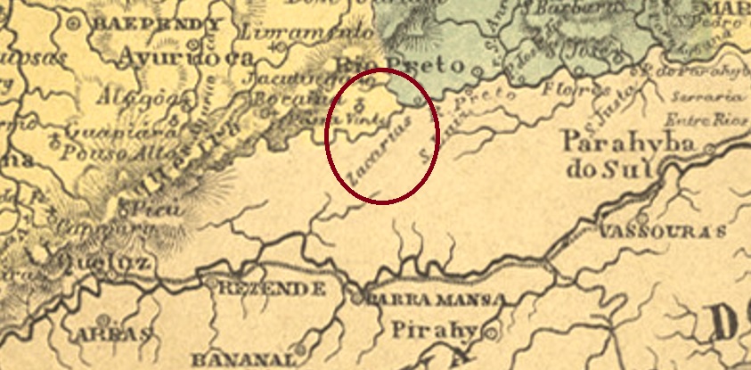
Other names: Porto do Zacharias, Ponte do Zacharias
See also Ponto do Zacharias (R. Koester: Carimbologia XXXII)
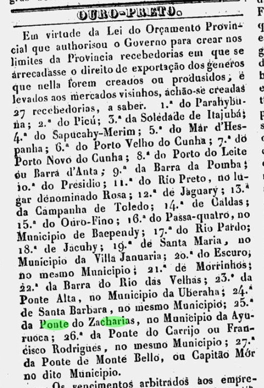
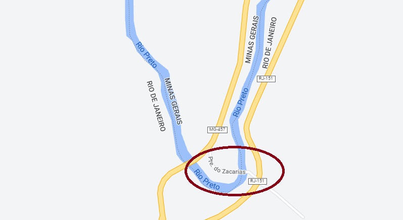
The Zacharias Bridge was built over the Rio Preto, close to the vila of the same name and right on the natural border between the provinces of Minas Gerais and Rio de Janeiro, 340 km south of Ouro Preto. On the Minas Gerais side, a Recebedoria (customs house) was established in July 1839 to collect export tax on goods sold in Rio de Janeiro.
O Universal, 08.07.1839
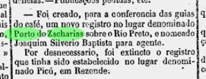
In October 1861, the province of Rio followed suit and also established a Registro on its side of the river to determine the “origin of imported coffee”.
Diario do Rio de Janeiro, 09.11.1861
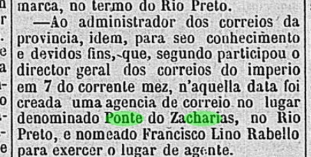
In August 1874, a post office was established at the Recebedoria on the Minas Gerais side, as reported by the regional press:
Diario de Minas, 25.11.1874
A second post office opening in 1881 is noted in the Directory of Imperial Post Offices (Tabella das Agencias do Correio do Imperio, Rio de Janeiro, 1885) in the “Freguesia” called Ponto do Zacharias. This incorrect designation led R. Koester to assume that this was a railway station post office (Carimbologia XXXII). According to Paulo Novaes (agenciaspostais.com.br), the post office was closed “around 1885”, and there was no railway line over the bridge yet. So far, no imperial postmark has appeared from there. See also (in Portuguese):
Andere Namen: Porto do Zacharias, Ponte do Zacharias
Siehe auch Ponto do Zacharias (R. Koester: Carimbologia XXXII)
Die Zacharias-Brücke wurde über dem Rio Preto gebaut, nah an der gleichnamigen Vila und direkt an der Naturgrenze zwischen den Provinzen Minas Gerais und Rio de Janeiro, 340 km südlich von Ouro Preto entfernt. Auf der Minas Gerais-Seite wurde im Juli 1839 eine Recebedoria (Zollhaus) eingerichtet, um die Ausfuhrsteuer über Waren einzukassieren, die in Rio de Janeiro verkauft wurden.
O Universal, 08.07.1839
Im Oktober 1861 zog die Provinz Rio nach und errichtete auch ein Registro auf ihrer Flussseite, um den „Ursprung des importierten Kaffees“ zu ermitteln.
Diario do Rio de Janeiro, 09.11.1861
Im August 1874 wurde entschieden, an der Recebedoria in Minas ein Postamt zu installieren, wie die Presse aus Minas Gerais berichtet:
Diario de Minas, 25.11.1874
Eine zweite Posteröffnung 1881 wird im Verzeichnis der kaiserlichen Postämter (Tabella das Agencias do Correio do Imperio, Rio de Janeiro, 1885) in der „Freguesia“ namens Ponto do Zacharias festgestellt. Diese falsche Ortsangabe führte R. Koester zur Annahme, es handelte sich hier um einen Bahnhofspostamt (Carimbologia XXXII). Laut Paulo Novaes (agenciaspostais.com.br) wurde das Postamt „ca. 1885“ geschlossen, und da war noch keine Bahnlinie über die Brücke. Bisher ist kein kaiserlicher Poststempel von dort aufgetaucht. Siehe auch (Portugiesisch):
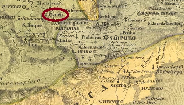
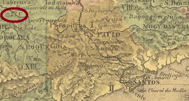
Villiers de l’Ile Adam: Carta (…) da Provincia de São Paulo, 1847
This village, old by Brazilian standards, was the chapel of N. Sra. da Candelária from February 1610 and was located on the south bank of the Tietê, barely 100 km west of the later provincial capital of São Paulo. Ytu became a freguesia in 1653, a vila in April 1657 and a town in February 1842.
Two years of origin for the local post office have been found. First in October 1824, as Nova Monteiro writes in Administrações e Agencias Postaes do Brasil Imperio (Brasil Filatelico/RJ, 1934-5; Reprint SPP 1994-1999). Then in 1844, according to the Directory of Imperial Post Offices (Tabella das Agencias do Correio do Imperio, Rio de Janeiro, 1885).
The first two postmarks have been definitively used in the pre-philatelic period. YSP-1615a was in use at least between 1825 and 1829 and was already made known by the RHM catalogue:
YSP-1615a (RHM P-SP-59)
Parallel to this – more precisely between 1825 and at least 1850 – YSP-1615b was in use, which can not only be seen in the RHM, but was also recorded with no. 1542 in the Catálogo de Carimbos Brasil-Império (S. Paulo, 1937, 1942) by Paulo Ayres:
YSP-1615b (RHM P-SP-60, P.A. 1542)
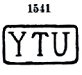
Then there came YSP-1615c, used between about 1843 and at least 1866. This postmark also exists in red; it can be seen in the Paulo Ayres (op. cit.) with no. 1541:
YSP-1615c (P.A. 1541)
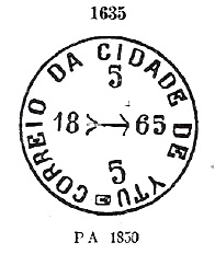
Its successor YSP-1615d came into use from about 1850 – also in red – and is also listed in Paulo Ayres, this time under no. 1635:
YSP-1615d (P.A. 1635)
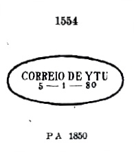
YSP-1615e was also in use at somewhat the same time and can also be seen in P. Ayres:
YSP-1615e (P.A. 1554) 1850ff-1869
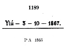
Also YSP-1615f, which also occurs in blue between 1866 and 1881, with P. Ayres no. 1189. However, the dot at the end may sometimes be missing:
YSP-1615f (P.A. 1189)
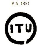
All the following postmarks have ITU written with I. ISP-0660a was in circulation from about 1866 and was given No. 1331 by P. Ayres:
ISP-0660a (P.A. 1331)
ISP-0660b apparently occurred in blue, was in use from ca. 1866 to ca. 1877 and has no. 1332 by P. Ayres:
ISP-0660b (P.A. 1332)
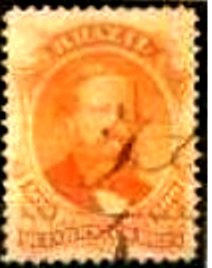
Five more postmarks followed as double circles until the end of the 19th century. The French type ISP-0660c (Coll. José L. Fevereiro) has the inscription ITÚ above and the asterisk between brackets below. Dates in the centre go from 1871 to 1879. ISP-0660d (Coll. Mário Celso Orsi Jr.) also exists in violet and blue, with internal dates from 1881 to 1886. Here the accent on the U is barely visible, if at all. ISP-0660e (Coll. Mário Celso Orsi Jr.) is also found in violet, has ITU written in wide letters at the top and a five-pointed star without brackets at the bottom, with inner dates from 1886 to 1890. On ISP-0660f (image from the internet), the letters of ITU are not quite as wide, and the accent on the U looks more like a dot. A specimen was seen, dated 1887. Finally, ISP-0660g (image by Luís C. Fritzen) is a second French type, but this time the letters of ITU are narrower. A specimen from 1897 was found.
Mário Celso Orsi Jr. also presents a handwritten cancellation from Itu:
1866ff (MO)
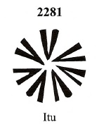
Then we have three mute cancellations from there. The first of these has already been presented by J. Dingler and K. W. Lopes in Mute Cancellations of the Brazil Empire / Carimbos Mudos do Brasil Império (Brazil Philatelic Association, Rio de Janeiro, 2000) under no. 2281:
BPA 2281
The second mute cancel comes from the Fuad Ferreira Fo. collection:
1867 (FF)
Lastly, another mute cancellation, as announced by Mário Celso Orsi Jr:
1872-1881 (MO)Atlas do Imperio do Brasil, 1868
Diese für brasilianische Verhältnisse alte Ortschaft war ab Februar 1610 die Kapelle von N. Sra. da Candelária und lag am Südufer des Tietê, knapp 100 km westlich der späteren Provinzhauptstadt São Paulo entfernt. Ytu wurde 1653 zur Freguesia, im April 1657 zur Vila und im Februar 1842 zur Stadt.
Zwei Entstehungsjahre fürs örtliche Postamt wurden gefunden. Erstmals im Oktober 1824, wie Nova Monteiro in Administrações e Agencias Postaes do Brasil Imperio (Brasil Filatelico/RJ, 1934-5; Reprint SPP 1994-1999) schreibt. Dann 1844, laut demVerzeichnis der kaiserlichen Postämter (Tabella das Agencias do Correio do Imperio, Rio de Janeiro, 1885).
Die ersten beiden Poststempel sind nachweislich in der Vorphila-Zeit verwendet worden. YSP-1615a war zumindest zwischen 1825 und 1829 in Gebrauch und wurde bereits durch den RHM-Katalog bekannt gemacht:
YSP-1615a (RHM P-SP-59)
Parallel dazu – genauer zwischen 1825 bis zumindest 1850 – wurde YSP-1615b verwendet, der nicht nur im RHM zu sehen ist, sondern auch mit Nr. 1542 im Catálogo de Carimbos Brasil-Império (S. Paulo, 1937, 1942) von Paulo Ayres registriert wurde:
YSP-1615b (RHM P-SP-60, P.A. 1542)
Danach kam YSP-1615c, verwendet zwischen ca. 1843 und mindestens 1866. Diesen Poststempel gibt es auch in Rot, er ist im Paulo Ayres (op. cit.) mit Nr. 1541 zu sehen:
YSP-1615c (P.A. 1541)
Sein Nachfolger YSP-1615d kam ab ca. 1850 in Gebrauch – auch in Rot – und ist ebenfalls in Paulo Ayres aufgelistet, diesmal unter Nr. 1635:
YSP-1615d (P.A. 1635)
Auch YSP-1615e wurde etwas zur gleichen Zeit gebraucht und ist auch im P. Ayres zu sehen:
YSP-1615e (P.A. 1554) 1850ff-1869
Ebenfalls YSP-1615f, der auch in Blau zwischen 1866 und 1881 vorkommt, mit P. Ayres Nr. 1189. Allerdings kann der Punkt am Ende manchmal fehlen:
YSP-1615f (P.A. 1189)
Alle folgenden Poststempel haben ITU mit I geschrieben. ISP-0660a war ab ca. 1866 im Umlauf und bekam von P. Ayres die Nr. 1331:
ISP-0660a (P.A. 1331)
ISP-0660b kommt angeblich in Blau vor, wurde von ca. 1866 bis ca. 1877 verwendet und hat Nr. 1332 bei P. Ayres:
ISP-0660b (P.A. 1332)
Es folgten noch fünf Poststempel als Doppelkreise bis Ende des 19. Jahrhunderts. Der Französische Typus ISP-0660c (Samml. José L. Fevereiro) hat oben die Inschrift ITÚ und unten des Sternchen zwischen Klammern. Daten in der Mitte von 1871 bis 1879. ISP-0660d (Samml. Mário Celso Orsi Jr.) gibt es auch in Violett und Blau, mit inneren Daten von 1881 bis 1886. Hier ist der Akzent auf dem U kaum oder nicht zu sehen. ISP-0660e (Samml. Mário Celso Orsi Jr.) kommt auch in Violett vor, hat oben ITU mit breiten Buchstaben geschrieben und unten einen fünfzackigen Stern ohne Klammer, dazu innere Daten von 1886 bis 1890. Bei ISP-0660f (Abb. aus dem Internet) sind die Buchstaben von ITU nicht ganz so breit, und der Akzent auf dem U sieht eher wie ein Punkt aus. Ein Exemplar gesehen, datiert 1887. Schließlich kommt mit ISP-0660g (Abb. Luís C. Fritzen) ein zweiter Französischer Typ dazu, wobei die Buchstaben von ITU diesmal schmäler sind. Ein Exemplar aus 1897.
Mário Celso Orsi Jr. kennt auch eine handschriftliche Entwertung aus Itu:
1866ff (MO)
Dann haben wir noch drei stumme Abstempelungen von dort. Die erste davon wurde bereits durch J. Dingler und K. W. Lopes in Mute Cancellations of the Brazil Empire / Carimbos Mudos do Brasil Império (Brazil Philatelic Association, Rio de Janeiro, 2000) unter Nr. 2281 vorgestellt:
BPA 2281
Die zweite stumme Abstempelung kommt aus der Sammlung Fuad Ferreira Fo.:
1867 (FF)
Zuletzt eine stumme Abstempelung, wie Mário Celso Orsi Jr. bekannt gab:
Villiers de l’Ile Adam: Carta (…) da Provincia de São Paulo, 1847
See also Iporanga (R. Koester: Carimbologia XXII)
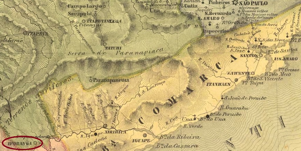
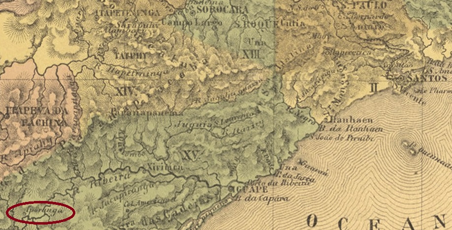
The name Yporanga (also spelled Iporanga) comes from the Tupi-Guarani and means Beautiful Waters. The old freguesia of Yporanga was established as early as December 1830 and was located at the mouth of the river of the same name in the Ribeira do Iguape in the Município of Apiahy, 310 km southwest of the provincial capital of São Paulo. In March 1843, the village went to the Vila of Xiririca and became a Vila itself in April 1873. It even became a town in December 1906, but was downgraded as a district of Apiahy between 1934 and 1936.
As can be read in the Directory of Imperial Post Offices (Tabella das Agencias do Correio do Imperio, Rio de Janeiro, 1885), there was a post office there since 1873. A 19th century postmark was found, unfortunately not the first. The French type ISP-0600a (Coll. Claudio Coelho) is a double circle with the inscription IPORANGA above and the asterisk between brackets below. The dates in the middle are so far from the period 1890-1904.
Atlas do Imperio do Brasil, 1868
Siehe auch Iporanga (R. Koester: Carimbologia XXII)
Der Name Yporanga (auch Iporanga geschrieben) kommt aus dem Tupi-Guarani und bedeutet Schönes Gewässer. Die alte Freguesia von Yporanga entstand bereits im Dezember 1830 und lag an der Mündung des gleichnamigen Flusses in den Ribeira do Iguape im Município von Apiahy. 310 km südwestlich der Provinzhauptstadt São Paulo entfernt. Im März 1843 ging der Ort zur Vila von Xiririca und wurde im April 1873 selber eine Vila. Im Dezember 1906 wurde daraus sogar eine Stadt, die allerdings zwischen 1934 und 1936 als Distrikt von Apiahy herabgestuft wurde.
Wie im Verzeichnis der kaiserlichen Postämter (Tabella das Agencias do Correio do Imperio, Rio de Janeiro, 1885) zu lesen ist, gab es dort ein Postamt seit 1873. Ein Poststempel des 19. Jahrhunderts wurde gefunden, leider nicht der erste. Der Französische Typus ISP-0600a (Samml. Claudio Coelho) ist ein Doppelkreis mit der Inschrift IPORANGA oben und dem Sternchen zwischen Klammern unten. Die bisherigen Daten in der Mitte entstammen dem Zeitraum 1890-1904.
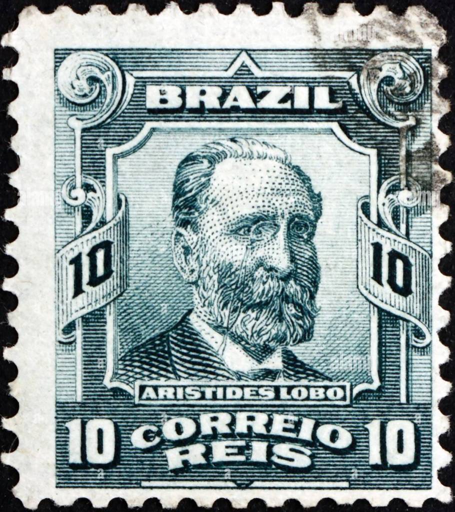
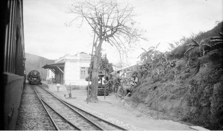
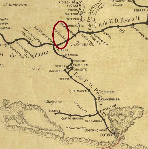
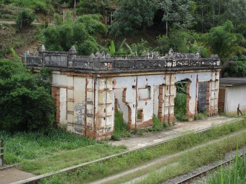
Ypiranga station (also spelled Ipiranga) was inaugurated in April 1865 by the E.F. Dom Pedro II railway company (Main Line) in the Município of Vassouras and was located on the north bank of the Paraíba do Sul River, 125 km northwest of the capital Rio de Janeiro. The railway line passed to E.F. Central do Brasil with the advent of the Republic (1889) and from 1975 until its closure in 1996 it belonged to Rede Ferroviaria Federal S.A. (estacoesferroviarias.com.br). The station has been located in the municipio of Barra do Piraí since February 1890 and has been called Aristides Lobo since about 1940, after a lawyer and politician (1838-1896), Brazil’s first Minister of the Interior.
MiNo. 163 – Scott # 174 – RHM 136
The Aristides Lobo railway station is now an abandoned ruin:
ca. 1930 (Photo: Robert S. Pratt in estacoesferroviarias.com.br)2016 (Photo: Gutierrez L. Coelho in estacoesferroviarias.com.br)
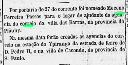
As reported by the Rio press, the station post office was created in April 1865:
Correio Mercantil, 30.04.1865
Probably the first station postmark remains undiscovered. Its successor is IRJ-0655a (agenciaspostais.com.br), a double circle with the inscription IPIRANGA at the top. The dates in the middle have so far been found for the period 1885-1888.
Estações do Rio de JAneiro, São Paulo e Minas Geraes, 1880
Anderer Name: Aristides Lobo (Est.)
Der Bahnhof Ypiranga (auch Ipiranga geschrieben) wurde im April 1865 durch die E.F. Dom Pedro II-Bahngesellschaft (Hauptlinie) im Município von Vassouras eingeweiht und lag am Nordufer des Flusses Paraíba do Sul, 125 km nordwestlich der Hauptstadt Rio de Janeiro entfernt. Die Bahnlinie ging mit dem Advent der Republik (1889) zu E.F. Central do Brasil über und von 1975 bis zur Stilllegung 1996 gehörte sie der Rede Ferroviaria Federal S.A. (estacoesferroviarias.com.br). Der Bahnhof liegt seit Februar 1890 im Municipio von Barra do Piraí und heißt seit ca. 1940 Aristides Lobo, nach einem Juristen und Politiker (1838-1896), Brasiliens erster Innenminister.
MiNr. 163 – Scott # 174 – RHM 136
Der Bahnhof Aristides Lobo ist heute eine verlassene Ruine:
ca. 1930 (Foto: Robert S. Pratt in estacoesferroviarias.com.br)2016 (Foto: Gutierrez L. Coelho in estacoesferroviarias.com.br)
Wie die Presse aus Rio berichtet, gab es das Bahnhofspostamt ab April 1865:
Correio Mercantil, 30.04.1865
Wahrscheinlich ist der erste Bahnhofsstempel noch unentdeckt. Sein Nachfolger ist IRJ-0655a (agenciaspostais.com.br), ein Doppelkreis mit der Inschrift IPIRANGA oben. Die Daten in der Mitte wurden bisher für den Zeitraum 1885-1888 gefunden.
Villiers de l’Ile Adam: Carta (…) da Provincia de São Paulo, 1847
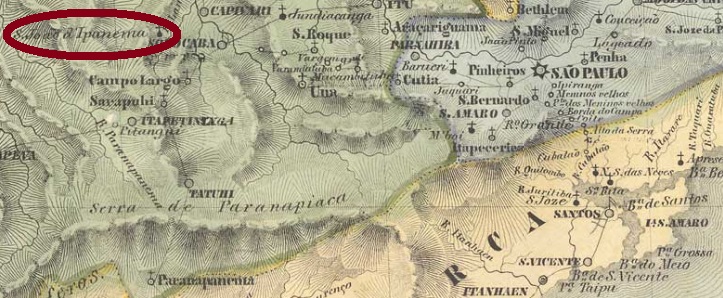
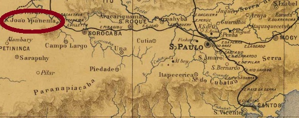
Another name: Fazenda Ipanema
See also João de Ipanema (SSP-1575) and Ipanema (R. Koester: Carimbologia XXII)
Since December 1876, the station of the E.F. Sorocabana Railway Company (also spelled Ypanema) was operating in the municipality of Sorocaba, about 120 km west of the provincial capital São Paulo. The line went in 1892 to the Cia. Sorocabana e Ytuana but returned to E. F. Sorocabana from 1919 until the end of operations in 1928. The settlement around the station continued to grow and in November 1944 became the district of Iperó, then in the municipality of Boituva. Since January 1964, the area around the former railway station has been a district of Iperó, which is called Fazenda Ipanema.
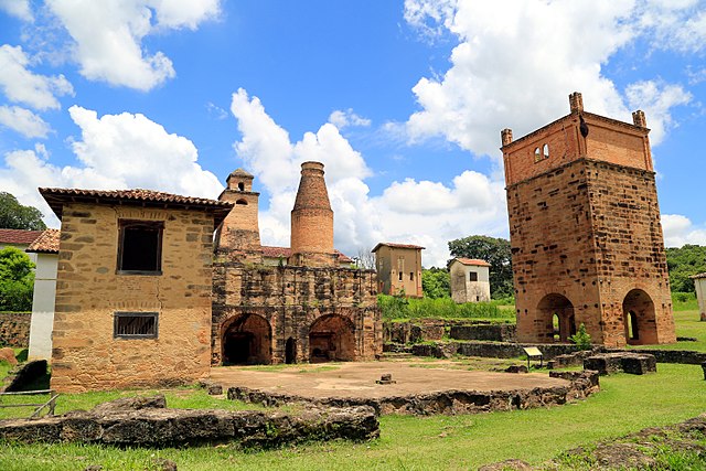
The railway supposed to transport the production of the Royal Ironworks (Real Fabrica de Ferro) Ipanema, the first iron processing plant in South America, which was in operation between 1810 and 1926, as extensively reported by Spix and Martius (Travels in Brazil in the Years 1817-1820, London, 1824):
Photo: Rubens Hardt (CC BY-SA 4.0)
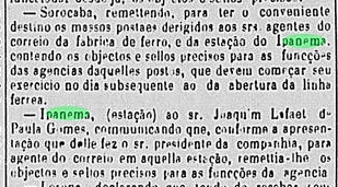
As can be read in the Imperial Mail Register (Tabella das Agencias do Correio do Imperio) from 1885, there was a station post office since 1876. This is confirmed by the press from Sao Paulo:
Correio Paulistano, 11 January 1877 (Official Acts 24.-31.12.1876)
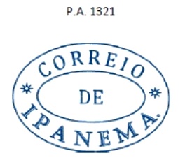
However, Helmut Ponge reports an opening as early as 1872 (in R. Koester, op. cit.). The postmarks here cheerfully alternate from one spelling to another, starting with ISP-0595a, which also exists in blue, was used until at least 1877 and can also be seen in Paulo Ayres’ Catálogo de Carimbos Brasil-Império (S. Paulo, 1937, 1942) under no. 1321.
ISP-0595a (P.A.1321)
This was followed by YSP-1700a (Coll. Mario Celso Orsi Jr.): a double circle with the inscription CORR(EIO) DO YPANEMA and the date over a horizontal line in the centre. It also occurs in blue and was seen until now dated 1878 and 1879. Then there came the French type ISP-1595b (image from the internet): this also exists in blue and dark purple, with the inscription IPANEMA at the top and the asterisk between brackets at the bottom, dated 1883-1885 in the centre. It was followed by YSP-1700b (Coll. Mário Celso Orsi Jr.). This double circle (only one sighted) reads YPANEMA at the top, unfortunately there is only an S visible at the bottom, perhaps for S. PAULO, with an 1886 date in the centre. The last postmark of the imperial period is ISP-1595c (image from the Internet): this double circle has the inscription AGENCIA DE IPANEMA at the top, an ornament in four-leaf clover at the bottom, plus dates from 1887 to 1892 in the middle.
J. M. Ribeiro Lisboa: Provincia de São Paulo, 1884
Anderer Name: Fazenda Ipanema
Siehe auch São João de Ipanema (SSP-1575) und Ipanema (R. Koester: Carimbologia XXII)
São João de Ipanema (auch Ypanema geschrieben) war seit Dezember 1876 ein Bahnhof der E.F. Sorocabana Bahngesellschaft, der im Município von Sorocaba lag, gut 120 km westlich der Provinzhauptstadt São Paulo. Die Linie ging 1892 zur Cia. UniãoSorocabana e Ytuana über, kehrte aber von 1919 bis zum Betriebsende 1928 zur E. F. Sorocabanazurück. Die Siedlung um den Bahnhof wuchs weiter und wurde im November 1944 zum Distrikt von Iperó, nun im Município von Boituva. Seit Januar 1964 ist das Gebiet um den ehemaligen Bahnhof ein Stadtteil von Iperó, der Fazenda Ipanema heißt.
Die Bahn sollte die Produktion der Königlichen Eisenhüttenwerk (Real Fabrica de Ferro) Ipanema transportieren, der ersten Eisen-Verarbeitungsanlage Südamerikas, die zwischen 1810 und 1926 in Betrieb war und sogar von Spix und Martius (Reise in Brasilien in den Jahren 1817-1820, München, 1823-31) ausführlich behandelt wurde:
Foto: Rubens Hardt (CC BY-SA 4.0)
Wie im Verzeichnis der kaiserlichen Postämter (Tabella das Agencias do Correio do Imperio) von 1885 zu lesen ist, gab es ein Bahnhofspostamt seit 1876. Dies wird durch die Presse aus São Paulo bestätigt:
Correio Paulistano, 11. Januar 1877 (Amtshandlungen v. 24.-31.12.1876)
Allerdings berichtet Helmut Ponge von einer Eröffnung bereits 1872 (in R. Koester, op. cit.). Die Poststempel hier wechseln munter von einer Schreibweise zur anderen ab, beginnend mit ISP-0595a, den es auch in Blau gibt, bis mindestens 1877 verwendet wurde und auch in Paulo Ayres’ Catálogo de Carimbos Brasil-Império, (S. Paulo, 1937, 1942) unter Nr. 1321 zu sehen ist.
ISP-0595a (P.A.1321)
Es folgte YSP-1700a (Samml. Mario Celso Orsi Jr.): ein Doppelkreis mit der Inschrift CORR(EIO) DO YPANEMA und dem Datum über einer waagerechten Linie in der Mitte. Er kommt auch in Blau vor und wurde bisher mit 1878 und 1879 datiert. Danach kam der Französischer Typus ISP-1595b (Abb. aus dem Internet): den gibt es auch in Blau und Dunkellila, mit der Inschrift IPANEMA oben und dem Sternchen zwischen Klammern unten, datiert 1883-1885 in der Mitte. Ihm folgte YSP-1700b (Samml. Mário Celso Orsi Jr.). In diesem Doppelkreis (nur ein Exemplar gesichtet) liest man YPANEMA oben, unten ist leider nur ein S zu sehen, vielleicht für S. PAULO, mit einem Datum aus 1886 in der Mitte. Der letzte Poststempel der Kaiserzeit ist ISP-1595c (Abb. aus dem Internet): dieser Doppelkreis hat oben die Inschrift AGENCIA DE IPANEMA, unten ein Ornament in vierblättrigem Kleeblatt, dazu Daten von 1887 bis 1892 in der Mitte.
Villiers de l’Ile Adam: Carta (…) da Provincia de São Paulo, 1847
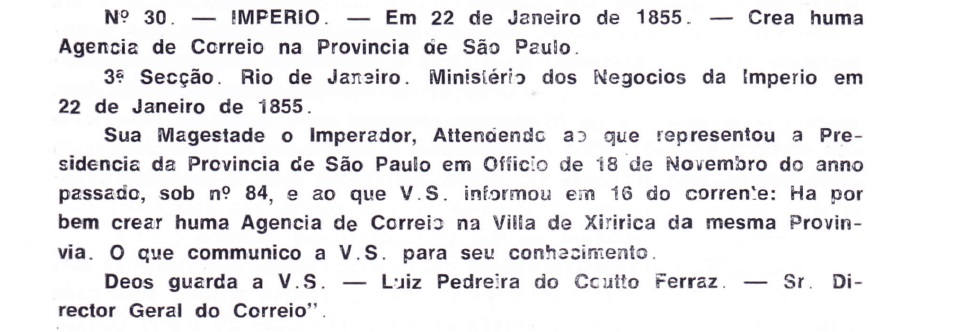
Another name: Eldorado (1948)
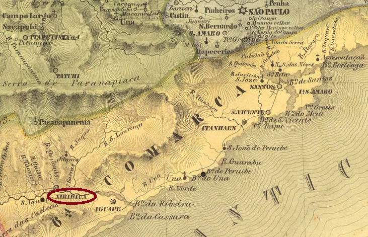
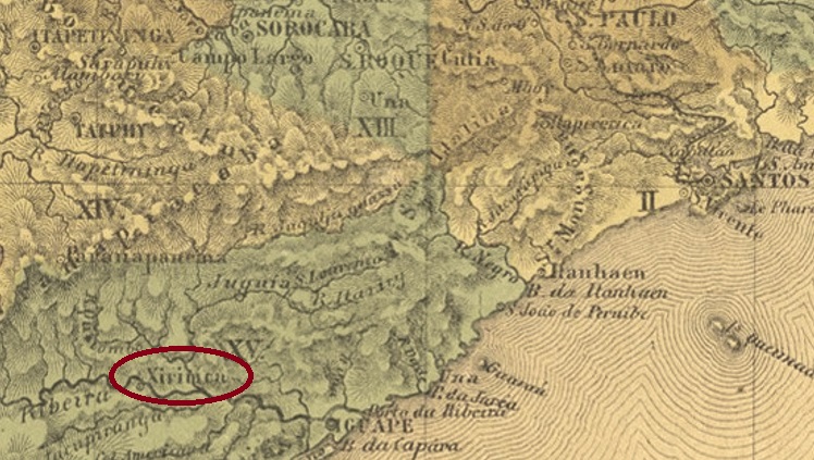
The indigenous word Xiririca means rapids, and the river Ribeira de Iguape is meant here. The chapel of N. Sra. da Guia de Xiririca was built in September 1757 on the south bank of the Ribeira de Iguape, 240 km southwest of the future provincial capital of São Paulo. In January 1763, the village was elevated to a freguesia in the Município of Iguape, in March 1842 Xiririca was declared a vila and in May 1895 a town, which has been called Eldorado since December 1948.
The local post office was established at least twice, although we do not yet know when the first creation took place. However, since the oldest postmark can be seen on stamp issues from 1843, we may assume that the postal agency was first opened around 1842, when Xiririca had become a vila. The second creation of the post office in January 1855 was reported by Aureo G. Santos in Agências de Correio Criadas e Suprimidas 1851, 1855, 1856 e 1857 (Brasil Filatélico 181, Rio de Janeiro, 1977):
Aureo G. Santos (op. cit.)
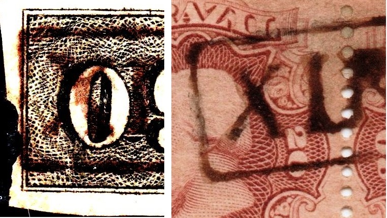
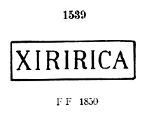
Nova Monteiro, in Administrações e Agencias Postaes do Brasil Imperio (Brasil Filatelico/RJ, 1934-5; Reprint SPP 1994-1999), gives a date of March 1855, but this may have been the commissioning of the agency. The first postmark XSP-1515a was used from about 1843 until at least 1876. It also exists in green, and Paulo Ayres has already shown it in Catálogo de Carimbos Brasil-Império (S. Paulo, 1937, 1942) under No. 1539:
XSP-1515a (P.A. 1539)
There is the variant XSP-1515b, which can be seen from about 1866 onwards and differs in the slightly sloping nature of the initial X:
XSP-1515a x XSP-1515b
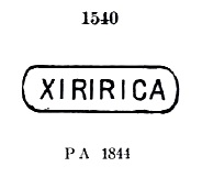
Parallel to this there came XSP-1515c, which was in use from c. 1844 to c. 1850 and is also known by Paulo Ayres (op. cit.) as no. 1540:
XSP-1515c (P.A.1540)
Two postmarks followed as double circles. XSP-1515d also exists in blue. It was used ca. 1877-1887 and could be seen in Paulo Ayres on p. 126:
XSP-1515d (P.A. p. 126)
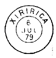
The French type XSP-1515e (Coll. Mario Celso Orsi Jr.) is also found in red. Here the above inscription is XIRIRICA; at the bottom is the small star between brackets, and the inner dates go from 1887 to 1898.
From Xiririca, Mario Celso Orsi Jr, also reported this mute cancel in the Empire:
(MO, wrong P.A. number)Atlas do Imperio do Brasil, 1868
Anderer Name: Eldorado (1948)
Das indigene Wort Xiririca bedeutet Stromschnelle, und gemeint wird hier der Fluss Ribeira de Iguape sein. Die Kapelle von N. Sra. da Guia de Xiririca wurde im September 1757 am Südufer des Ribeira de Iguape errichtet und lag 240 km südwestlich der späteren Provinzhauptstadt São Paulo entfernt. Im Januar 1763 wurde der Ort zur Freguesia im Município von Iguape erhoben, im März 1842 wurde Xiririca zur Vila und im Mai 1895 zu einer Stadt erklärt, die seit Dezember 1948 Eldorado heißt.
Das örtliche Postamt wurde mindestens zweimal ins Leben gerufen, wobei wir noch nicht wissen, wann das erste Mal stattfand. Da aber der älteste Poststempel auf Markenausgaben von 1843 zu sehen ist, darf man annehmen, dass die Postagentur erstmals um 1842 eröffnet wurde, als Xiririca eine Vila geworden war. Über die zweite Entstehung des Postamtes im Januar 1855 hat Aureo G. Santos in Agências de Correio Criadas e Suprimidas 1851, 1855, 1856 e 1857 (Brasil Filatélico 181, Rio de Janeiro, 1977) berichtet:
Aureo G. Santos (op. cit.)
Nova Monteiro gibt in Administrações e Agencias Postaes do Brasil Imperio (Brasil Filatelico/RJ, 1934-5; Reprint SPP 1994-1999) ein Datum aus März 1855 an, aber dieses könnte die Inbetriebnahme der Agentur gewesen sein. Das erste Poststempel XSP-1515a wurde von ca. 1843 bis mindestens 1876 verwendet. Es gibt ihn auch in grün, und Paulo Ayres hat ihn bereits in Catálogo de Carimbos Brasil-Império (S. Paulo, 1937, 1942) unter Nr. 1539 gezeigt:
XSP-1515a (P.A. 1539)
Davon gibt es die Variante XSP-1515b, die ab ca. 1866 zu sehen ist und sich durch die leicht geneigte Art der Initiale X unterscheidet:
XSP-1515a x XSP-1515b
Parallel dazu kam XSP-1515c, der von ca. 1844 bis ca. 1850 in Gebrauch war und auch durch Paulo Ayres (op. cit.) unter Nr. 1540 bekannt ist:
XSP-1515c (P.A.1540)
Es folgten zwei Poststempel als Doppelkreise. XSP-1515d gibt es auch in blau. Er wurde ca. 1877-1887 verwendet und war in Paulo Ayres auf S. 126 zu sehen:
XSP-1515d (P.A. p/S. 126)
Der französische Typus XSP-1515e (Samml. Mario Celso Orsi Jr.) kommt auch in rot vor. Hier lautet die obige Inschrift XIRIRICA; unten ist der kleine Stern zwischen Klammern, und die Daten im Inneren gehen von 1887 bis 1898.
Aus Xiririca zeigte Mario Celso Orsi Jr, auch diesen stummen Stempel im Kaiserreich:
Other names: Colonia militar de Chapecó, Ruy Barbosa
The present-day município of Xanxerê in the state of Santa Catarina, originated in 1880 as a “military colony” of the settlement of Chapecó. The military presence in the region was no coincidence, as it was the object of a long diplomatic dispute between Brazil and Argentina, who each claimed the area for themselves. This dispute only came to an end in 1894 – that is, already in the Republic – thanks to an USA arbitration in favour of Brazil. In 1890, the military colony passed to the district of Generozópolis in the Município of Palmas.
After the international dispute over the region, another one flared up, now between the states of Paraná and Santa Catarina, culminating in a civil war, the so-called Guerra do Contestado (1912-1916). The peace negotiations that followed declared almost the entire region to be Santa Catarina territory. Thus, in August 1917, Xanxerê became the district of Chapecó, to be declared a vila four months later. Barely two years later, in September 1919, Xanxerê was a town, called Ruy Barbosa between 1923 and 1929. In April 1931, the town was downgraded as a district of Chapecó, and regained the status of município in December 1953.
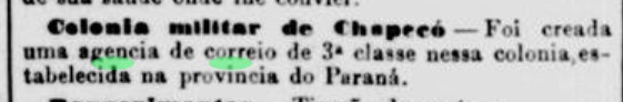
The local post office was established in June 1882, according to the Rio press:
Jornal do Commercio/RJ, 27.06.1882
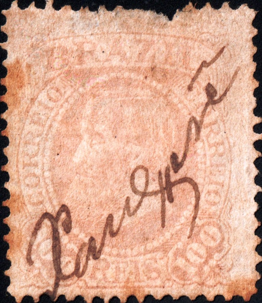
Apparently, the official postmark was not ready in time, for only a handwritten cancellation (Samml. José A. Junges) is known in the Empire:
(JJ) 1883ffCarta da Republica dos Estados Unidos do Brasil, 1892
Andere Namen: Colonia militar de Chapecó, Ruy Barbosa
Der heutige Município von Xanxerê im Bundesstaat Santa Catarina entstand 1880 als „Militärkolonie“ der Siedlung von Chapecó. Die Militärpräsenz in der Region war kein Zufall, denn diese war Objekt eines langen diplomatischen Streits zwischen Brasilien und Argentinien, die das Gebiet jeweils für sich beanspruchten. Dieser Streit kam erst 1894 –also schon in der Republik – zu Ende, dank eines zugunsten Brasiliens vergebenen Schiedsspruchs der USA. 1890 gehörte die Militärkolonie dem Distrikt von Generozópolis im Município von Palmas.
Nach dem internationalen Streit um die Region entflammte ein weiterer, nun zwischen den Bundesstaaten Paraná und Santa Catarina ausgetragen, der in einem Bürgerkrieg gipfelte, die so genannte Guerra do Contestado (1912-1916). Die darauffolgenden Friedensverhandlungen erklärten fast die gesamte Region zum Gebiet von Santa Catarina. So wurde Xanxerê im August 1917 zum Distrikt von Chapecó, um vier Monate später zur Vila erklärt zu werden. Knapp zwei Jahre danach, im September 1919, war Xanxerê eine Stadt, die zwischen 1923 und 1929 Ruy Barbosa hieß. Im April 1931 wurde der Ort als Distrikt von Chapecó herabgestuft, und erhielt den Status eines Município im Dezember 1953 wieder.
Das örtliche Postamt wurde im Juni 1882 ins Leben gerufen, wie die Presse aus Rio mitteilte:
Jornal do Commercio/RJ, 27.06.1882
Offenbar war der amtliche Poststempel nicht rechtzeitig fertig geworden, denn nur eine handschriftliche Entwertung (Samml. José A. Junges) ist aus dem Kaiserreich bekannt:
Villiers de l’Ile Adam: Carta (…) da Provincia de São Paulo, 1847
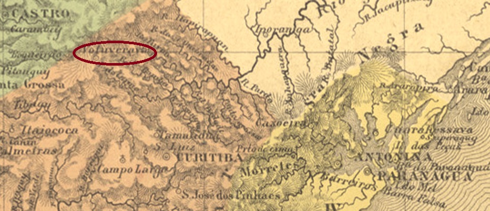
Another name: Rio Branco do Sul (1947)
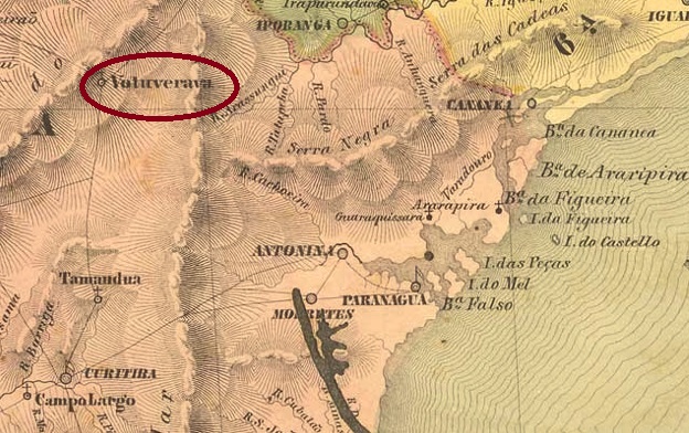
The old settlement of Votuverava (Shining Mountain, in Tupi-Guarani) was already documented about 1831 and became the freguesia of N. Sra. do Amparo do Votuverava in April 1855, located 30 km north of the provincial capital Curitiba. In March 1871, it was promoted to a Vila, which was called Rio Branco from February 1908. The following period must have been less pleasant, because in October 1938 it was downgraded as a district in the Município of Cerro Azul. But nine years later, the place became an autonomous municipality again, now under the name Rio Branco do Sul.
Both Nova Monteiro (Administrações e Agencias Postaes do Brasil Imperio, in Brasil Filatelico/RJ, 1934-5; Reprint SPP 1994-1999) and the Directory of Imperial Post Offices (Tabella das Agencias do Correio do Imperio, Rio de Janeiro, 1885) agree that there was a post office there from October 1865. Only one postmark for the Empire was found, unfortunately not the oldest one. VPR-0240b (Coll. José A. Junges) is a plain double circle with the inscription VOTUVERAVA at the top. The dates in the middle originate from the period 1881-1887.
Atlas do Imperio do Brasil, 1868
Anderer Name: Rio Branco do Sul (1947)
Die alte Siedlung Votuverava (Glänzender Berg, in Tupi-Guarani) war ab ca. 1831 überliefert und wurde im April 1855 zur Freguesia von N. Sra. do Amparo do Votuverava, die 30 km nördlich der Provinzhauptstadt Curitiba lag. Im März 1871 fand der Aufstieg zur Vila statt, die ab Februar 1908 Rio Branco hieß. Die folgende Zeit dürfte weniger erfreulich verlaufen sein, denn im Oktober 1938 erfolgte die Herabstufung als Distrikt im Município von Cerro Azul. Aber neun Jahre später wurde der Ort wieder eine autonome Gemeinde, nun unter dem Namen Rio Branco do Sul.
Sowohl Nova Monteiro (Administrações e Agencias Postaes do Brasil Imperio, in Brasil Filatelico/RJ, 1934-5; Reprint SPP 1994-1999) als auch das Verzeichnis der kaiserlichen Postämter (Tabella das Agencias do Correio do Imperio, Rio de Janeiro, 1885) stimmen darüber überein, dass es dort ab Oktober 1865 ein Postamt gab. Nur ein Poststempel fürs Kaiserreich wurde gefunden, leider nicht der älteste. VPR-0240b (Samml. José A. Junges) ist ein schlichter Doppelkreis mit der Inschrift VOTUVERAVA oben. Die Daten in der Mitte entstammen dem Zeitraum 1881-1887.
Estações do Rio de Janeiro, São Paulo e Minas Geraes, 1880
Text update of June 2, 2024
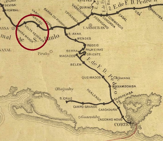
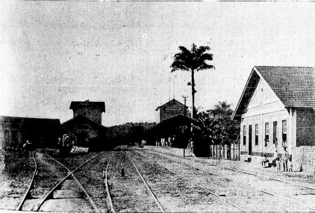
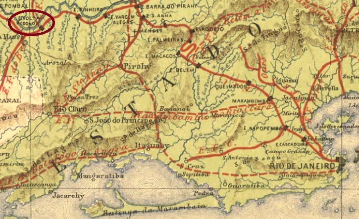
Volta Redonda (Round Arch, here referring to the Parahyba do Sul River) station was inaugurated in September 1871 by the E.F. Dom Pedro II (São Paulo Line) in the município of Barra Mansa and was located on the south bank of the Parahyba do Sul River, 130 km northwest of the capital Rio de Janeiro. The railway line went to E.F. Central do Brasil after 1889, and from 1975 until its closure in 1996 it belonged to Rede Ferroviária Federal S.A. The station building has long since been demolished (estacoesferroviarias.com.br).
Photo: Revista da Semana 6.8.1905 (in estacoesferroviarias.com.br)
Around the station, the settlement continued to grow, becoming a district in December 1890 and an independent município in July1954.
According to the Imperial Post Office Directory (Tabella das Agencias do Correio do Imperio, Rio de Janeiro, 1885), there was a post office in the station from 1871. Four postmarks were found for the 19th century. VRJ-1730a (Coll. Paulo Comelli) is an ellipse with the inscription EST(AÇÃO)/VOLTA RE(DONDA). The only known example is purple and was used on a D. Pedro issue of 1866. VRJ-1730b (agenciaspostais.com.br) is a double circle with the inscription VOLTA REDONDA at the top. Again, only one example exists, dated 1877 in the centre. Its successor VRJ-1730c (Coll. Dieter Kerkhoff) is similar, but has an ornament in lozenge at the bottom. Here there is also only one example, now from 1889. Finally, VRJ-1730d (image from the internet) is also a double circle with the same inscription at the top. Below one reads here (EST.), and the dates inside go from 1889 to at least 1894.
In the meantime, another postmark from Volta Redonda has turned up: VRJ-1730e (Coll. Marcio Duarte) should fit chronologically between VRJ-1730b and VRJ-1730c:
VRJ-1730e (MD) 1883ff-1885, also in blueE.F. Central do Brasil, 1890
Textaktualisierung am 2. Juni 2024
Der Bahnhof Volta Redonda (Runder Bogen, hier ist der Fluss Parahyba do Sul gemeint) wurde im September 1871 durch die E.F. Dom Pedro II (São Paulo-Abzweigung) im Município von Barra Mansa eingeweiht und lag am Südufer des Flusses Parahyba do Sul, 130 km nordwestlich der Hauptstadt Rio de Janeiro. Die Bahnlinie ging nach 1889 zur E.F. Central do Brasil und von 1975 bis zur Stilllegung 1996 gehörte sie der Rede Ferroviária Federal S.A. Das Bahnhofsgebäude wurde längst abgerissen (estacoesferroviarias.com.br).
Foto: Revista da Semana 6.8.1905 (in estacoesferroviarias.com.br)
Rund um den Bahnhof wuchs die Siedlung weiter, sie wurde im Dezember 1890 zum Distrikt und im Juli 1954 zum selbständigen Município.
Wie im Verzeichnis der kaiserlichen Postämter (Tabella das Agencias do Correio do Imperio, Rio de Janeiro, 1885) zu lesen ist, gab es im Bahnhof ein Postamt ab 1871. Vier Poststempel wurden fürs 19. Jahrhundert gefunden. VRJ-1730a (Samml. Paulo Comelli) ist eine Ellipse mit der Inschrift EST(AÇÃO)/VOLTA RE(DONDA). Das einzig bekannte Exemplar hat die Farbe lila und wurde auf eine D. Pedro Ausgabe aus 1866 verwendet. VRJ-1730b (agenciaspostais.com.br) ist ein Doppelkreis mit der Inschrift VOLTA REDONDA oben. Auch hier nur ein Exemplar vorhanden, datiert 1877 in der Mitte. Sein Nachfolger VRJ-1730c (Samml. Dieter Kerkhoff) ist ihm ähnlich, hat aber ein Ornament in Raute unten dazu. Auch nur ein Exemplar, diesmal aus 1889. Schließlich, VRJ-1730d (Abb. aus dem Internet) ist auch ein Doppelkreis mit gleicher Inschrift oben. Unten liest man hier (EST.), und die Daten im Inneren gehen von 1889 bis mindestens 1894.
Inzwischen ist ein weiterer Poststempel aus Volta Redonda aufgetaucht: VRJ-1730e (Samml. Marcio Duarte) dürfte chronologisch zwischen VRJ-1730b und VRJ-1730c passen:
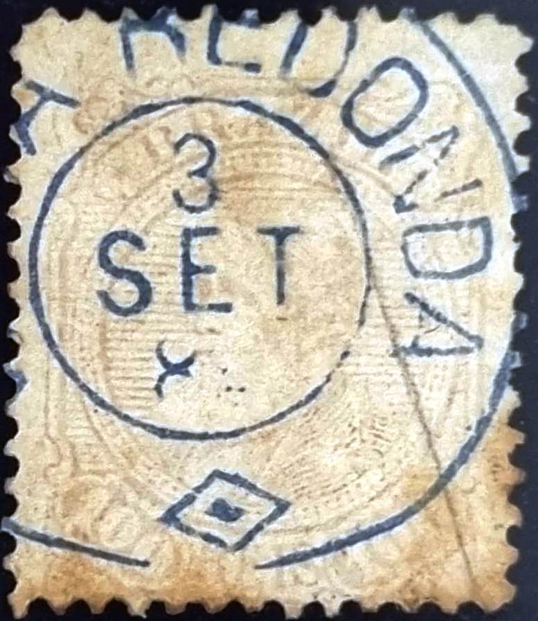
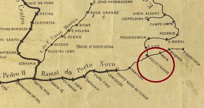
Other names: Valla Grande, Volta Grande de Além Parahyba
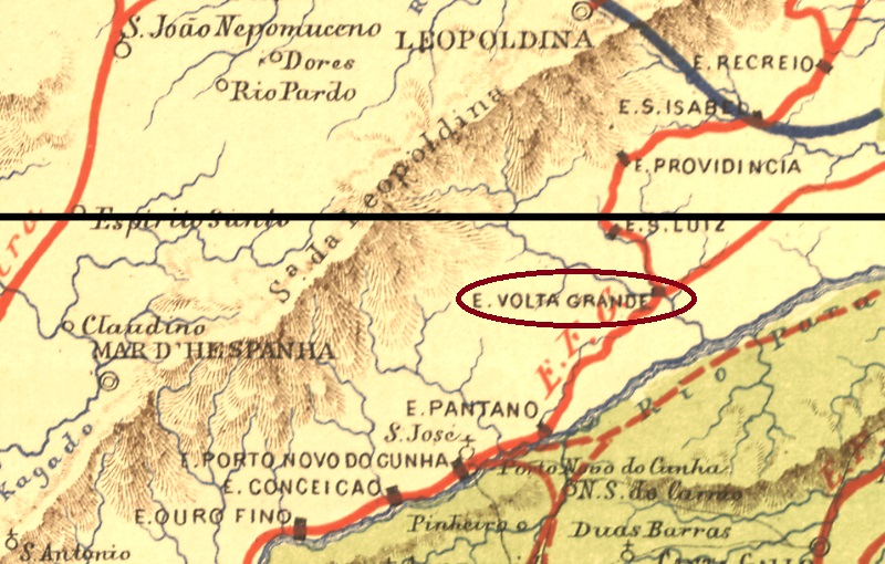
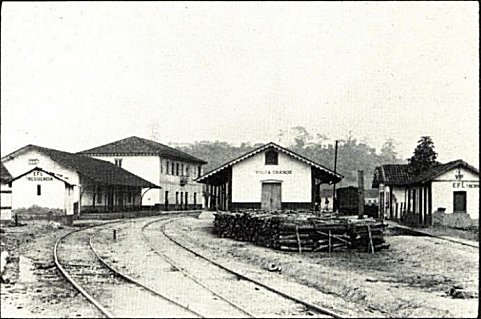
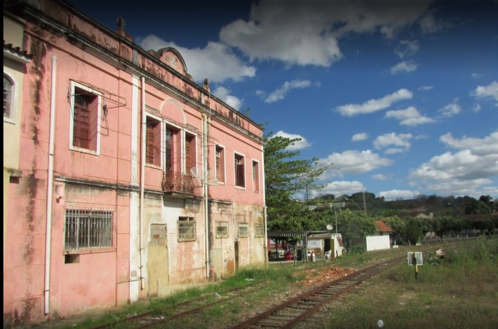
The Volta Grande railway station was inaugurated in August 1874 by the Estrada de Ferro Leopoldina in the município of Mar d’Hespanha, located on the south bank of the Angu River, 300 km south of the provincial capital Ouro Preto. The railway line belonged to Rede Ferroviária Federal S.A. from 1975 until its closure in 1996. Today, the station building serves as accommodation for railway employees (estacoesferroviarias.com.br).
Ca. 1940 (Photo: Preserve)Photo: Decio Marques, 2021 (estacoesferroviarias.com.br):
Around the station, the settlement continued to grow and became a district in the município of Além-Parahyba in March 1891. Volta Grande has been an independent município since December 1938.
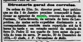
Three years of origin for the station post office were found. The first one was around December 1874, according to the Rio press. However, the station is here called Valla Grande:
Jornal do Commercio/RJ, 30.12.1874
The second post office opening is said to have taken place in 1878, as listed in the Directory of Imperial Post Offices (Tabella das Agencias do Correio do Imperio, Rio de Janeiro, 1885). Finally, Paula Sobrinho writes in História Postal de Minas Gerais (Belo Horizonte, 1997) that there was a post office there since July 1881.
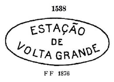
Five town postmarks and two mute postmarks were found for the 19th century. VMG-3220a is probably the first among them. It was in use from the beginning until at least 1876 and was already presented by Paulo Ayres in Catálogo de Carimbos Brasil-Império, (S. Paulo, 1937, 1942) under no. 1538:
VMG-3220a (P.A.1538)
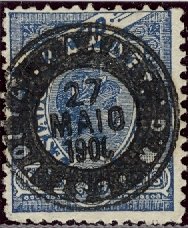
It was followed by the enigmatic VMG-3220b (Coll. José A. Junges): a three-liner with the inscription AGENCIA/DO CORREIO/DE VOLTA GRANDE, without frame or date. Then there came two stamps as double circles. VMG-3220c (Coll. José A. Junges) has only the inscription VOLTA GRANDE at the top, with internal dates from 1884 to 1886. VMG-3220d (Coll. José A. Junges) has now the inscription (EST.) at the bottom, with dates in the middle from 1884 to 1893. VMG-3220e (Coll. Márcio Protzner) is a beautiful negative-look postmark:
VMG-3220e (MP) 1894ff-1901
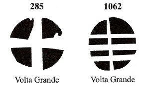
The two mute cancellations are listed in Mute Cancellations of the Brazil Empire / Carimbos Mudos do Brasil Império (Brazil Philatelic Association, Rio de Janeiro, 2000) by J. Dingler and K.W. Lopes under nos. 285 and 1062. BPA 285 is also listed under Paulo Ayres (op. cit.) with no. 18:
BPA 285 (P.A. 18, 1874ff); 1062Estações do Rio de Janeiro, São Paulo e Minas Geraes, 1880
Andere Namen: Valla Grande, Volta Grande de Além Parahyba
Der Bahnhof Volta Grande wurde im August 1874 durch die Estrada de Ferro Leopoldina im Município von Mar d’Hespanha eingeweiht und lag am Südufer des Flusses Angu, 300 km südlich der Provinzhauptstadt Ouro Preto entfernt. Die Bahnlinie gehörte von 1975 bis zur Stilllegung 1996 der Rede Ferroviária Federal S.A. (estacoesferroviarias.com.br). Heute dient das Bahnhofsgebäude als Unterkunft für Bahnmitarbeiter.
Ca. 1940 (Foto: Preserve)Foto Decio Marques, 2021 (estacoesferroviarias.com.br)
Um den Bahnhof herum wuchs die Siedlung weiter und wurde im März 1891 ein Distrikt im Município vom Além-Parahyba. Seit Dezember 1938 ist Volta Grande ein selbständiger Município.
Drei Entstehungsjahre fürs Bahnhofspostamt wurden gefunden. Erstmals um Dezember 1874, wie aus der Presse aus Rio hervorgeht. Allerdings heißt der Bahnhof hier Valla Grande:
Jornal do Commercio/RJ, 30.12.1874
Die zweite Postamteröffnung soll 1878 stattgefunden haben, wie im Verzeichnis der kaiserlichen Postämter (Tabella das Agencias do Correio do Imperio, Rio de Janeiro, 1885) aufgelistet. Schließlich schreibt Paula Sobrinho in História Postal de Minas Gerais (Belo Horizonte, 1997), dass es dort seit Juli 1881 ein Postamt gab.
Fünf Ortsstempel und zwei stumme Stempel wurden für das 19. Jahrhundert gefunden. VMG-3220a ist wohl der erste darunter. Er war von Beginn an bis mindestens 1876 in Verwendung und wurde bereits durch Paulo Ayres in Catálogo de Carimbos Brasil-Império, (S. Paulo, 1937, 1942) unter Nr. 1538 vorgestellt:
VMG-3220a (P.A.1538)
Ihm folgte der rätselhafte VMG-3220b (Samml. José A. Junges): ein Dreizeiler mit der Inschrift AGENCIA/DO CORREIO/DE VOLTA GRANDE, ohne Rahmen oder Datumsangabe. Danach kamen zwei Stempel als Doppelkreise. VMG-3220c (Samml. José A. Junges) hat lediglich die Inschrift VOLTA GRANDE oben, mit inneren Daten von 1884 bis 1886. VMG-3220d (Samml. José A. Junges) hat nun dazu die Angabe (EST.) unten, mit Daten in der Mitte von 1884 bis 1893. VMG-3220e (Samml. Márcio Protzner) ist ein wunderschöner Poststempel in Negativ-Look:
VMG-3220e (MP) 1894ff-1901
Die zwei stummen Entwertungen sind in Mute Cancellations of the Brazil Empire/Carimbos Mudos do Brasil Império (Brazil Philatelic Association, Rio de Janeiro, 2000) von J. Dingler und K.W. Lopes unter den Nr. 285 und 1062 zu sehen. BPA 285 ist auch unter Paulo Ayres (op. cit.) mit Nr. 18 aufgelistet: