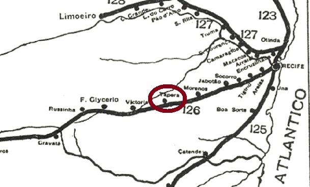
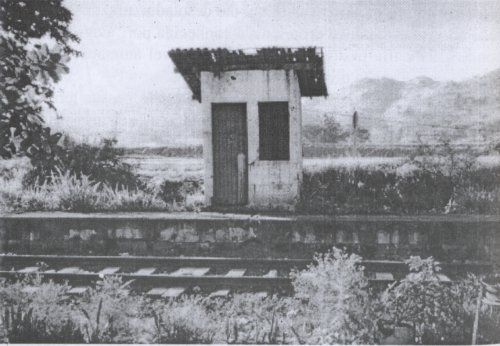
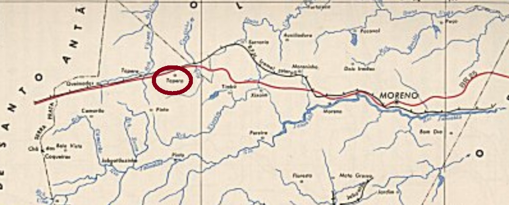
Tapera station was inaugurated in November 1888 by the E.F. Central de Pernambuco railway company (Central Line) in the Município of Jaboatão and was located about 40 km west of the provincial capital Recife. The line went to Great Western in 1904, to Rede Ferroviária do Nordeste in 1950 and to Rede Ferroviária Federal S.A. in 1975 until its closure in 1996. Since October 1928, the station has been in the Município of Moreno. Today, however, quite little remains of it (estacoesferroviarias.com.br):
Luiz Rubem Bonfim: E.F. Central de Pernambuco, 2002 (estacoesferroviarias.com.br)
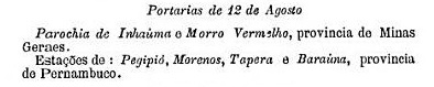
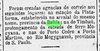
Hard to believe, but there was a post office there from August 1889, as shown in the postal report (Boletim Postal) of the following month:
Boletim Postal 5, Sep/89
The station postmark in the 19th century is TPE-0620a (Col. Ginaldo Bezerra da Silva): a double circle with the inscriptions E. DA TAPERA above and (PERNAMBUCO) below. The only specimen seen has a date of 1891 in the centre.
estacoesferroviarias.com.br
Der Bahnhof Tapera wurde im November 1888 durch die E.F. Central de Pernambuco Bahngesellschaft (Zentrumlinie) im Município von Jaboatão eingeweiht und lag ca. 40 km westlich der Provinzhauptstadt Recife entfernt. Die Linie ging 1904 zur Great Western, 1950 zur Rede Ferroviária do Nordeste und 1975 bis zur Stilllegung 1996 zur Rede Ferroviária Federal S.A. Seit Oktober 1928 befindet sich der Bahnhof im Município von Moreno. Heute ist allerdings nicht viel davon übriggeblieben (estacoesferroviarias.com.br):
Luiz Rubem Bonfim: E.F. Central de Pernambuco, 2002 (estacoesferroviarias.com.br)
Kaum zu glauben, aber dort gab es ab August 1889 ein Postamt, wie aus dem Postbericht (Boletim Postal) vom darauffolgenden Monat hervorgeht:
Boletim Postal 5, Sept./89
Der Bahnhofsstempel im 19. Jahrhundert ist TPE-0620a (Col. Ginaldo Bezerra da Silva): ein Doppelkreis mit den Inschriften E. DA TAPERA oben und (PERNAMBUCO) unten. Das einzige gesehene Exemplar trägt in der Mitte die Jahreszahl 1891.
Villiers de l’Ile Adam: Carta (…) da Provincia da Bahia, 1848
Another name: Santa Terezinha (1928)
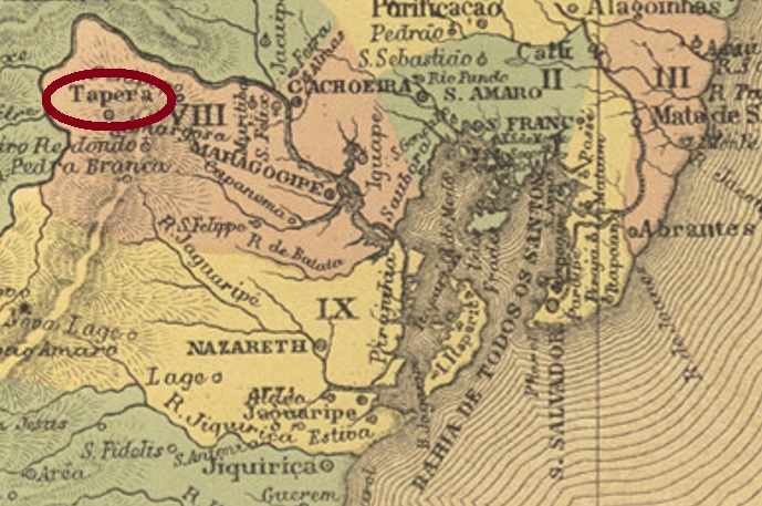
The Freguesia of Nossa Senhora da Conceição da Tapera was established in April 1843 in the Município of Cachoeira, 200 km west of the provincial capital of Salvador da Bahia. In October 1849, the village rose to the status of vila, but was demoted as a district of Amargosa in April 1877. It was promoted again as a município in May 1890, and since June 1928 the municipality has been called Santa Teresinha.
Two foundation dates for the local post office have been found. First, in September 1866, as stated in the Nova Monteiros Administrações e Agencias Postaes do Brasil Imperio (Brasil Filatelico/RJ, 1934-5; Reprint SPP 1994-1999). Then in 1868, as listed in the Directory of Imperial Post Offices (Tabella das Agencias do Correio do Imperio, Rio de Janeiro, 1885).
Three postmarks exist for the 19th century. First TBA-0725b (Coll. Fuad Ferreira Fo.): a double circle with the inscription TAPERA on top. The dates in the centre go from 1881 to 1889. Then TBA-0725c, as illustrated in Paulo Ayres’ Catálogo de Carimbos Brasil-Império (S. Paulo, 1937, 1942) under no. 1728:
TBA-0725c (P.A. 1728) 1885ff
Most recently TBA-0725d (Coll. José A. Junges). This double circle not only has the inscription TAPERA at the top, but also a five-pointed star as an ornament at the bottom. The inner dates go from 1889 to 1892.
Atlas do Imperio do Brasil, 1868
Andere Name: Santa Terezinha (1928)
Die Freguesia von Nossa Senhora da Conceição da Tapera wurde im April 1843 im Município von Cachoeira errichtet und lag 200 km westlich der Provinzhauptstadt Salvador da Bahia entfernt. Im Oktober 1849 stieg der Ort zur Vila auf, wurde aber im April 1877 als Distrikt von Amargosa degradiert. Der Wiederaufstieg als Município erfolgte im Mai 1890, und seit Juni 1928 heißt die Gemeinde Santa Teresinha.
Drei Poststempel sind für den 19. Jahrhundert überliefert. Zunächst TBA-0725b (Samml. Fuad Ferreira Fo.): ein Doppelkreis mit der Inschrift TAPERA oben. Die Daten in der Mitte gehen von 1881 bis 1889. Dann TBA-0725c, wie in Paulo Ayres‘ Catálogo de Carimbos Brasil-Império (S. Paulo, 1937, 1942) unter der Nr. 1728 abgebildet:
TBA-0725c (P.A. 1728) 1885ff
Zuletzt TBA-0725d (Samml. José A. Junges). Bei diesem Doppelkreis gibt es nicht nur die Inschrift TAPERA oben, sondern auch einen fünfzackigen Stern als Ornament unten. Die inneren Daten gehen von 1889 bis 1892.
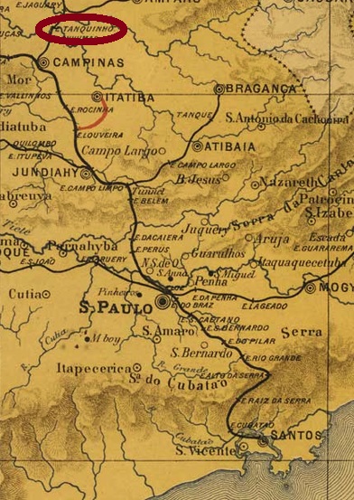
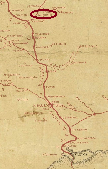
Tanquinho station was inaugurated in May 1875 by the Cia. Mogyana railway company (main line) and was located near Campinas, 110 northwest of the provincial capital São Paulo. From 1971 until its closure in 1997, the line belonged to FEPASA (estacoesferroviarias.com.br).
It has not yet been possible to determine when the station post office came into being, but it must have been between 1885 and 1887. For the agency was not listed in the Directory of Imperial Post Offices (Tabella das Agencias do Correio do Imperio, Rio de Janeiro, 1885), but it was included in the Postal Timetable (Horário Postal) for 1887 of the province of São Paulo. The only 19th century postmark so far is TSP-1405a (Coll. José A. Junges): a double circle with the inscription TANQUINHO on top and a black dot as ornament below. The stamp bears no date but was used on a Madrugada issue of 1894.
Estações Ferroviarias do Rio de Janeiro, São Paulo e Minas Geraes, 1880
Der Bahnhof Tanquinho wurde im Mai 1875 durch die Cia. Mogyana Bahngesellschaft (Hauptlinie) eingeweiht und lag bei Campinas, 110 nordwestlich der Provinzhauptstadt São Paulo entfernt. Von 1971 bis zur Stilllegung 1997 gehörte die Linie der FEPASA (estacoesferroviarias.com.br).
Es konnte bisher nicht ermittelt werden, wann das Bahnhofspostamt entstand, aber es muss zwischen 1885 und 1887 stattgefunden haben. Denn die Agentur war nicht im Verzeichnis der kaiserlichen Postämter (Tabella das Agencias do Correio do Imperio, Rio de Janeiro, 1885) aufgelistet, wohl aber im Postfahrplan (Horário Postal) für 1887 der Provinz São Paulo eingetragen. Der bisher einzige Poststempel im 19. Jahrhundert ist TSP-1405a (Samml. José A. Junges): ein Doppelkreis mit der Inschrift TANQUINHO oben und einem schwarzen Punkt als Ornament unten. Der Stempel trägt kein Datum, wurde aber auf eine Madrugada-Ausgabe von 1894 verpasst.
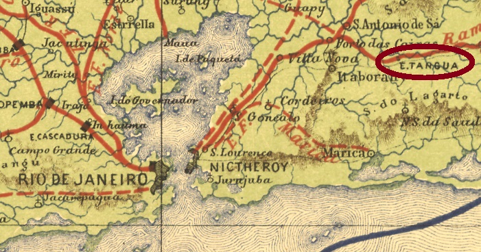
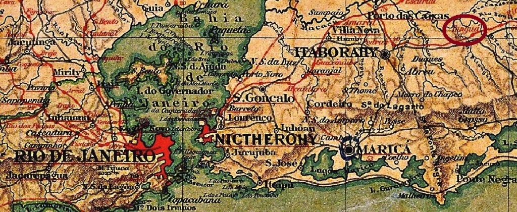
Tanguá station was inaugurated in March 1878 by the C.F.C. Niteroiense railway company and was located at Itaborahy, just under 70 km east of the capital Rio de Janeiro. In 1887 the railway line went to the E.F. Leopoldina and from 1975 until its closure in 1996 it belonged to Rede Ferroviária Federal S.A. (estacoesferroviarias.com.br). The settlement around the station continued to grow and became the district of Itaborahy in January 1924. Tanguá has been an independent município since December 1995.
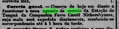
The station post office started its operations in February 1878, according to the Rio press:
Jornal do Commercio/RJ, 07.02.1878
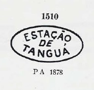
Two station postmarks were found for the 19th century. First came TRJ-1905a, as illustrated in Paulo Ayres’ Catálogo de Carimbos Brasil-Império, (S. Paulo, 1937, 1942) under no. 1510:
TRJ-1905a (P.A. 1510) 1878ff
It was followed by TRJ-1905b (Coll. Fuad Ferreira Fo.): a French type with the inscription TANGUÁ above and the star between brackets below, dated 1883-1886 in the centre. Next came TRJ- 1905c (agenciaspostais.com.br): a double circle with the inscription TANGUÁ above and an ornament in X below. The dates in the middle go from 1893 to 1897.
Almanak Laemmert, 1892
Aktualisiert am 11. Januar 2022
Der Bahnhof Tanguá wurde im März 1878 durch die C.F.C. Niteroiense-Bahngesellschaft eingeweiht und lag bei Itaborahy, knapp 70 km östlich der Hauptstadt Rio de Janeiro entfernt. 1887 ging die Bahnlinie zur E.F. Leopoldina und von 1975 bis zur Stilllegung 1996 gehörte sie der Rede Ferroviária Federal S.A. (estacoesferroviarias.com.br). Die Siedlung um den Bahnhof wuchs weiter und wurde im Januar 1924 zum Distrikt von Itaborahy. Seit Dezember 1995 ist Tanguá ein eigenständiger Município.
Das Bahnhofspostamt startete seinen Betrieb im Februar 1878, wie die Presse aus Rio mitteilte:
Ihm folgte TRJ-1905b (Samml. Fuad Ferreira Fo.): ein Französischer Typus mit der Inschrift TANGUÁ oben und dem Stern zwischen Klammern unten, datiert 1883-1886 in der Mitte. Danach kam TRJ- 1905c (agenciaspostais.com.br): ein Doppelkreis mit der Inschrift TANGUÁ oben und einem Ornament in X unten. Die Daten in der Mitte gehen von 1893 bis 1897.
Carta da Republica dos Estados Unidos do Brasil, 1892
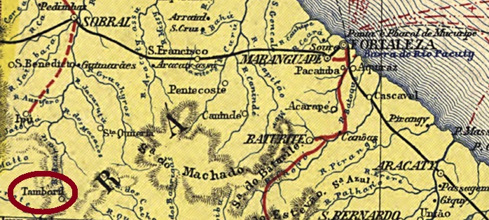
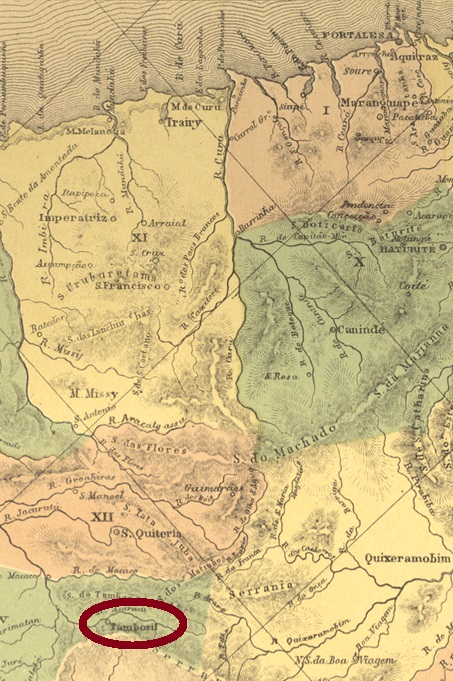
This locality was a district of the municipality of Ipu from December 1853, located 290 km southwest of the provincial capital Fortaleza. In October 1854, the place rose to become a vila in its own município.
Nova Monteiro writes in Administrações e Agencias Postaes do Brasil Imperio (Brasil Filatelico/RJ, 1934-5; Reprint SPP 1994-1999) that there had been a post office there since August 1866. The oldest postmark so far is TCE-0335b (Coll. José A. Junges): a double circle with the inscription TAMBORIL at the top. The dates in the centre were found for the period 1889-1908.
Atlas do Imperio do Brasil, 1868
Diese Ortschaft war ab Dezember 1853 ein Distrikt der Gemeinde Ipu, der 290 km südwestlich der Provinzhauptstadt Fortaleza lag. Im Oktober 1854 stieg der Ort zu einer Vila im eigenen Município auf.
Nova Monteiro schreibt in Administrações e Agencias Postaes do Brasil Imperio (Brasil Filatelico/RJ, 1934-5; Reprint SPP 1994-1999), dass es dort seit August 1866 ein Postamt gab. Der bisher älteste Poststempel ist TCE-0335b (Samml. José A. Junges): ein Doppelkreis mit der Inschrift TAMBORIL oben. Die Daten in der Mitte wurden für den Zeitraum 1889-1908 gefunden.
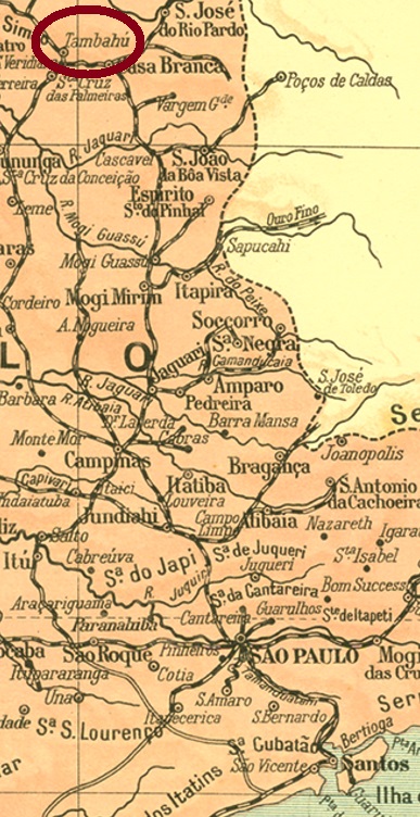
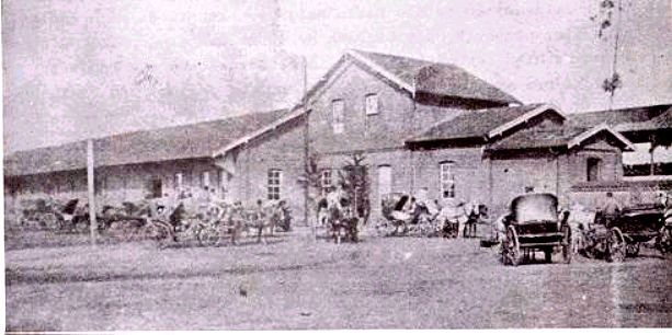
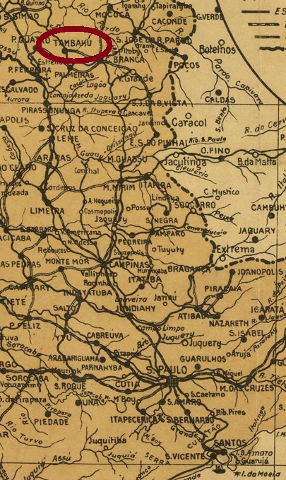
Inaugurated in October 1887 by the Cia. Mogyana railway company, Tambahu station (now spelled Tambaú) was located on the main line in the Município of Casa Branca, 260 km north of the provincial capital São Paulo. And it remained that way until it was closed in 1959. Around the station, the settlement grew to become a district in 1892, a vila in August 1898, and Tambaú has been a town since December 1906.
Early 20. century (from estacoesferroviarias.com.br)
The station post office was established in March 1888, as one can read in the Rio Press:
Gazeta de Noticias/RJ, 28/03/1888
The 19th century postmark is TSP-1400a (image from the internet): a double circle with the inscriptions EST. TAMBAHU above and S. PAULO below. The only example so far bears a date from 1894 in the centre.
Arthur D. Ribeiro: Estado de São Paulo, 1924
Der Bahnhof Tambahu (heute Tambaú geschrieben) wurde im Oktober 1887 durch die Cia. Mogyana Eisenbahngesellschaft eingeweiht und lag auf der Hauptstrecke im Município von Casa Branca, 260 km nördlich der Provinzhauptstadt São Paulo entfernt. Und so ist es bis zur Stilllegung 1959 geblieben. Rund um den Bahnhof wuchs die Siedlung zum Distrikt 1892, im August 1898 wurde sie eine Vila, und seit Dezember 1906 ist Tambaú eine Stadt.
Am Anfang des 20. Jahrhunderts (aus estacoesferroviarias.com.br)
Das Bahnhofspostamt entstand im Marz 1888, wie man in der Rio Presse lesen kann:
Gazeta de Noticias/RJ, 28.03.1888
Der Poststempel des 19. Jahrhunderts ist TSP-1400a (Abb. aus dem Internet): ein Doppelkreis mit den Inschriften EST. TAMBAHU oben und S. PAULO unten. Das bisher einzige Exemplar trägt ein Datum aus 1894 in der Mitte.
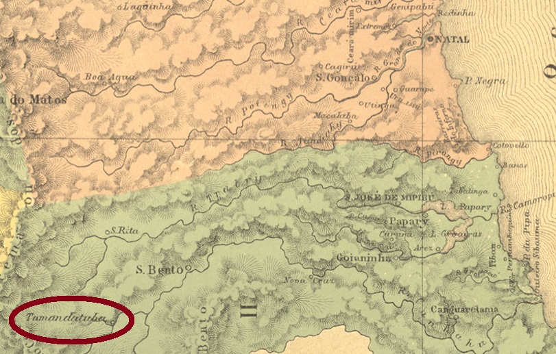
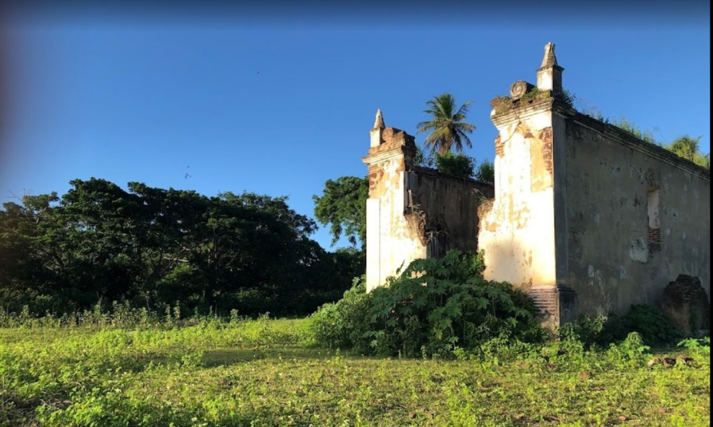
Tamatanduba is another settlement in 19th century Imperial Brazil that has since disappeared from the map. This settlement was probably a sugar cane fazenda in the freguesia of Villa Flor near Canguaretama, more than 90 km south of the provincial capital of Natal. At the beginning of the republic, the superior district was called Cuitezeiras, then Pedro Velho from November 1908. The Indian word Tamatanduba is said to mean hard-shelled fruit. All that remains of the former village today is the ruined chapel:
Photo: Marcos Vinicius (CC)
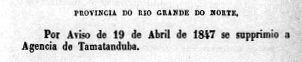
We do not know when the local post office was established. It was finally closed in April 1847, as we can read in the report of the Imperial Ministry:
Relatorio do Ministerio do Imperio, April 1847
No postmark has yet been found from this place.
Villiers de l’Ile Adam: Carta (…) das Provincias do Rio Grande do Norte e Parahiba, 1848
Tamatanduba ist eine weitere Ortschaft im kaiserlichen Brasilien des 19. Jahrhunderts, die inzwischen von der Landkarte verschwunden ist. Diese Siedlung war wohl eine Zuckerrohr-Fazenda in der Freguesia von Villa Flor bei Canguaretama, die über 90 km südlich von der Provinzhauptstadt Natal entfernt lag. Am Anfang der Republik hieß der übergeordnete Distrikt Cuitezeiras, seit November 1908 dann Pedro Velho. Das indianische Wort Tamatanduba soll Hartschaliger Obst bedeuten. Aus dem früheren Ort ist heute nur noch die Kapellenruine geblieben:
Foto: Marcos Vinicius (CC)
Wir wissen nicht, wann das örtliche Postamt entstanden ist. Dieses wurde im April 1847 endgültig dichtgemacht, wie man im Bericht des kaiserlichen Ministeriums lesen kann:
Relatorio do Ministerio do Imperio, April 1847
Kein Poststempel wurde bisher aus diesem Ort gefunden.
See also Itapecerica (MG), in R. Koester’s Carimbologia XXIV
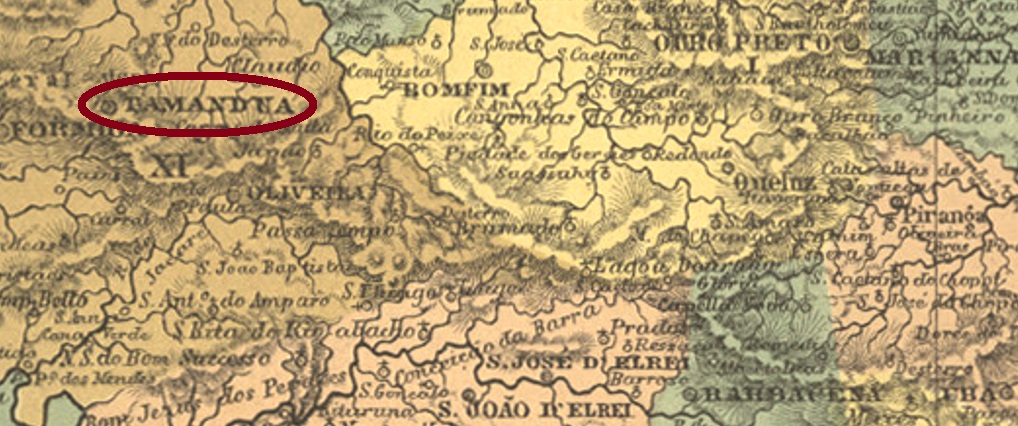
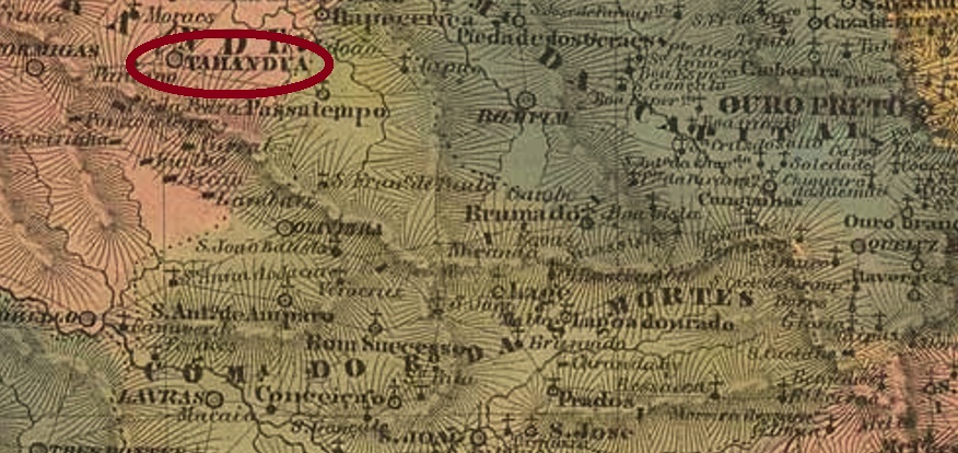
The freguesia of São Bento de Tamanduá (Saint Benedict of the Anteater) was created in 1757 by royal order (Ordem Régia) in the county of S. João d’El-Rey and was located 260 km west of the later provincial capital Ouro Preto. As early as November 1789, it became a vila and in October 1862 a town, which has been called Itapecerica since October 1882. The word from the Indian language means flat stone.
There were no less than three foundation dates for the local post office. First, in May 1809, as Paula Sobrinho writes in História Postal de Minas Gerais (Belo Horizonte, 1997). Then in October 1833, as Nova Monteiro notes in Administrações e Agencias Postaes do Brasil Imperio (Brasil Filatelico/RJ, 1934-5; Reprint SPP 1994-1999). And finally in October 1838, as listed both by Reinhold Koester and in the Directory of Imperial Post Offices (Tabella das Agencias do Correio do Imperio, Rio de Janeiro, 1885).
Three 19th century postmarks have been found. TMG-3500a is the pre-philatelic cancellation recorded with dates between 1827 and at least 1843 and is known through the RHM catalogue (here with and without frame) under P-MG-63. However, the last A seems to be somewhat smaller in reality. This letter would also have an accent above, as shown on the right in the picture (fig. from the internet):
TMG-3500a (RHM P-MG-63 recte) 1839 (EB)
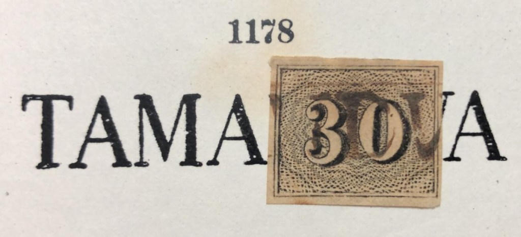
TMG-3500b is very similar to its predecessor, but has slightly narrower letters and no accent over the last A. It also exists in sepia and red, and was presented by Paulo Ayres (Catálogo de Carimbos Brasil-Império, S. Paulo, 1937, 1942) under no. 1178:
TMG-3500b (P.A. 1178) 1850ff-1869
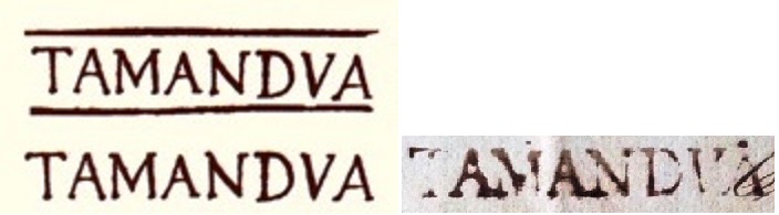
The successor cancel TMG-3500c (Coll. José A. Junges) is a French type with the above inscription TAMANDUÁ and the typical star between brackets at the bottom. Dates in the centre from 1883 to 1896.
Villiers de l’Ile Adam: Carta (…) da Provincia de Minas Gerais, 1849
Siehe auch Itapecerica (MG), in R. Koesters Carimbologia XXIV
Die Freguesia von São Bento de Tamanduá (Heiliger Benedikt des Ameisenbärs) entstand 1757 durch königlichen Befehl (Ordem Régia) in der Gemarkung S. João d’El-Rey und lag 260 km westlich der späteren Provinzhauptstadt Ouro Preto entfernt. Bereits im November 1789 wurde daraus eine Vila und im Oktober 1862 eine Stadt, die seit Oktober 1882 Itapecerica heißt. Das Wort aus der Indianersprache bedeutet flacher Stein.
Nicht weniger als drei Gründungsdaten fürs örtliche Postamt waren zu finden. Erstens im Mai 1809, wie Paula Sobrinho in História Postal de Minas Gerais (Belo Horizonte, 1997) schreibt. Dann im Oktober 1833, wie Nova Monteiro in Administrações e Agencias Postaes do Brasil Imperio( Brasil Filatelico/RJ, 1934-5; Reprint SPP 1994-1999) vermerkt. Und schließlich im Oktober 1838, wie sowohl durch Reinhold Koester als auch im Verzeichnis der kaiserlichen Postämter (Tabella das Agencias do Correio do Imperio, Rio de Janeiro, 1885) aufgelistet.
Drei Poststempel für den 19. Jahrhundert wurden gefunden. TMG-3500a ist die Vorphila-Abstempelung, die bisher mit Daten zwischen 1827 und mindestens 1843 registriert wurde und durch den RHM-Katalog (hier mit und ohne Rahmen) unter P-MG-63 bekannt ist. Allerdings scheint das letzte A in Wirklichkeit etwas kleiner zu sein. Darauf wäre ein Akzent, wie rechts im Bild (Abb. aus dem Internet) zu sehen:
TMG-3500a (RHM P-MG-63 recte) 1839 (EB)
TMG-3500b ist sehr ähnlich wie sein Vorgänger, hat aber etwas schmalere Buchstaben und keinen Akzent auf dem letzten A. Es gibt ihn auch in sepia und rot, er wurde von Paulo Ayres (Catálogo de Carimbos Brasil-Império, S. Paulo, 1937, 1942) mit Nr. 1178 präsentiert:
TMG-3500b (P.A. 1178) 1850ff-1869
Der Nachfolgestempel TMG-3500c (Samml. José A. Junges) ist ein französischer Typus mit der obigen Inschrift TAMANDUÁ und dem typischen Stern zwischen Klammern unten. Daten in der Mitte von 1883 bis 1896.
Villiers de l’Ile Adam: Carta (…) das Provincias de Pernambuco, Alagoas e Sergipe, 1848
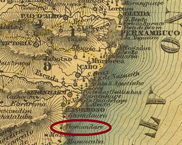
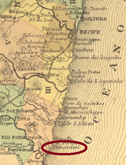
Tamandaré was a freguesia of the municipality of Rio Formoso, located 100 km south of the provincial capital Recife. It became a district in May 1905 and a município in September 1995. The word from the Tupi-guarani language means anteater of the different kind.
Two creation dates for the local post office were found. A sure indication that it was closed in the meantime. First in May 1858, as Nova Monteiro writes in Administrações e Agencias Postaes do Brasil Imperio (in Brasil Filatelico/RJ, 1934-5; Reprint SPP 1994-1999). Then again in 1873, as shown in the postal report (Relatório Postal) of December 1886. A postmark of the second period of operation was found. TPE-0615b (Coll. José A. Junges) is a plain double circle with the above inscription TAMANDARÉ. All specimens were found on Southern Cross issues from 1890.
Atlas do Imperio do Brasil, 1868
Tamandaré war eine Freguesia der Gemeinde Rio Formoso, die 100 km südlich der Provinzhauptstadt Recife entfernt lag. Im Mai 1905 wurde daraus aus Distrikt und im September 1995 ein Município. Das Wort aus der Tupi-guarani-Sprache bedeutet Ameisenbär der anderen Sorte.
Zwei Gründungdaten fürs örtliche Postamt wurden gefunden. Ein sicheres Indiz dafür, dass es zwischendurch geschlossen wurde. Erstens im Mai 1858, wie Nova Monteiro in Administrações e Agencias Postaes do Brasil Imperio(in Brasil Filatelico/RJ, 1934-5; Reprint SPP 1994-1999) schreibt. Dann wieder 1873, wie aus dem Postbericht (Relatório Postal) von Dezember 1886 hervorgeht. Ein Poststempel der zweiten Betriebsperiode wurde gefunden. TPE-0615b (Samml. José A. Junges) ist ein schlichter Doppelkreis mit der obigen Inschrift TAMANDARÉ. Bisherige Exemplare wurden auf Ausgabe des Kreuzes des Südens aus 1890 gefunden.
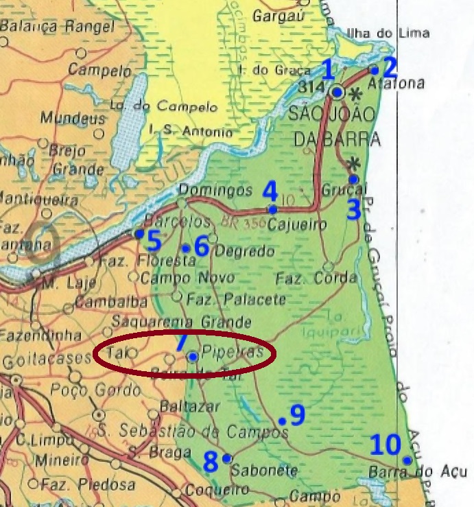
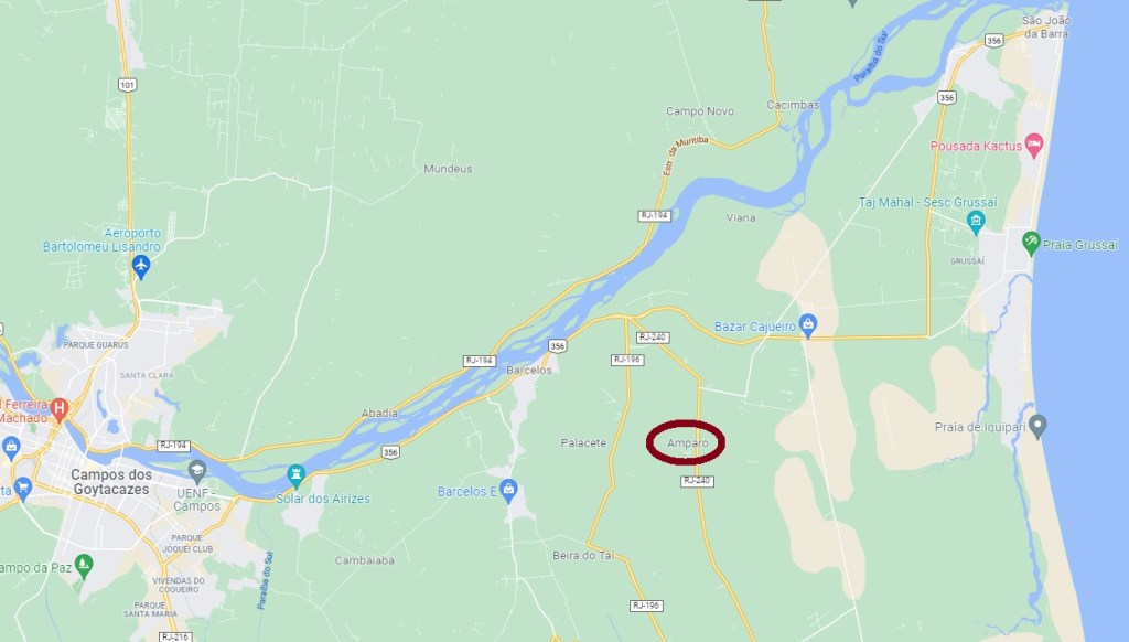
The Freguesia of Nossa Senhora do Amparo do Tahy was founded in November 1873 in the municipality of São João da Barra, 300 km northeast of the capital Rio de Janeiro. Around 1933, the district name was changed to Pipeiras, and it has remained that way until today.
As can be read in the Directory of Imperial Post Offices (Tabella das Agencias do Correio do Imperio, Rio de Janeiro, 1885), a post office was built there in 1878 and operated until October 1919 (agenciaspostais.com.br). Also nearby, the E.F. Campos a São Sebastião railway company built a station before the turn of the century, where a post office also operated from about 1898. The imperial postmark of the place is TRG-1605a (image from the Internet): a double circle with the inscription FREG. DE TAHY above and an ornament in circle below, flanked by two semicircles. The dates in the centre go so far from 1889 to 1899.
Google Maps
Andere Namen: Itahy, Amparo, Pipeiras
Die Freguesia von Nossa Senhora do Amparo do Tahy wurde im November 1873 in der Gemeinde São João da Barra gegründet und lag 300 km nordöstlich der Hauptstadt Rio de Janeiro entfernt. Um 1933 wurde der Distriktname zu Pipeiras geändert, und so ist es bis heute geblieben.
Wie im Verzeichnis der kaiserlichen Postämter (Tabella das Agencias do Correio do Imperio, Rio de Janeiro, 1885) zu lesen ist, wurde dort 1878 ein Postamt errichtet, das bis Oktober 1919 in Betrieb war (agenciaspostais.com.br). Auch in der Nähe baute die E.F. Campos a São Sebastião Bahngesellschaft vor Jahrhundertwende einen Bahnhof, wo ab ca. 1898 auch ein Postamt betrieben wurde. Der kaiserliche Poststempel des Ortes ist TRG-1605a (Abb. aus dem Internet): ein Doppelkreis mit der Inschrift FREG. DE TAHY oben und einem Ornament in Kreis unten, das durch zwei Halbkreisen flankiert wird. Die Daten in der Mitte gehen bisher von 1889 bis 1899.