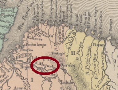
Since the 18th century, São Miguel do Guamá was a freguesia of Ourém, located on the north bank of the Guamá River, just under 150 km east of the future provincial capital Belém do Pará. In May 1833, the village was renamed São Miguel da Cachoeira, but when it became a villa in October 1870, the old name came back. Since May 1891, São Miguel do Guamá has been a town.
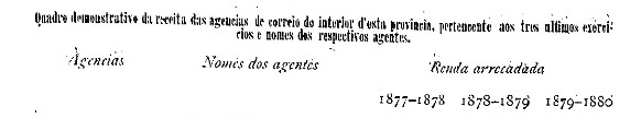
According to the Imperial Mail Register (Tabella das Agencias do Correio do Imperio, 1885), there has been a post office there since 1882. But this is likely to be a reopening, because the agency was already in operation in 1877, as the report of the provincial president of February 1881 shows:
Relatorio do Presidente da Provincia, February 1881.
So far, no postmark of the imperial era has been found for this village.
Villiers de l’Ile Adam: Carta (…) das Provincias do Grão Pará e Alto Amazonas
Anderer Name: São Miguel da Cachoeira
Seit dem 18. Jahrhundert war São Miguel do Guamá eine Freguesia von Ourém, die am Nordufer des Flusses Guamá, knapp 150 km östlich der künftigen Provinzhauptstadt Belém do Pará entfernt lag. Im Mai 1833 wurde der Ort zu São Miguel da Cachoeira umbenannt, aber als im Oktober 1870 daraus eine Villa wurde, kam der alter Name zurück. Seit Mai 1891 ist São Miguel do Guamá eine Stadt.
Laut Verzeichnis der kaiserlichen Postämter (Tabella das Agencias do Correio do Imperio, 1885) gibt es dort seit 1882 ein Postamt. Das dürfte aber eine Wiedereröffnung sein, denn bereits 1877 war die Agentur in Betrieb, wie der Bericht des Provinzpräsidenten von Februar 1881 zeigt:
Relatorio do Presidente da Provincia, Februar 1881.
Bisher ist kein Poststempel der Kaiserzeit für diese Ortschaft gefunden worden.
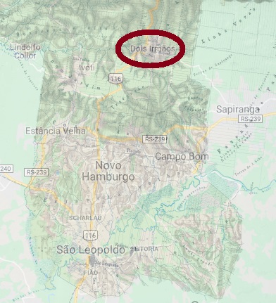
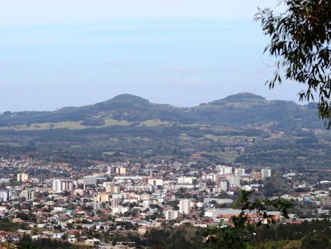
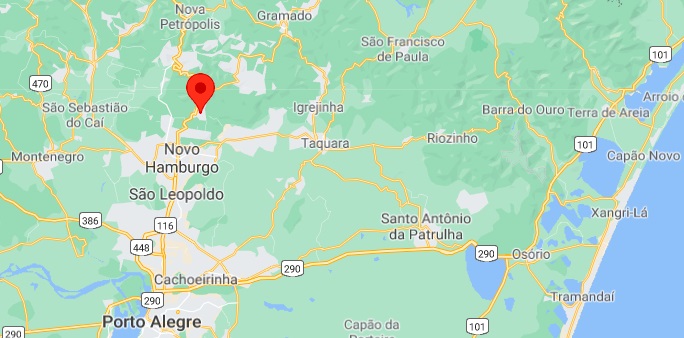
São Miguel de Dois Irmãos was a freguesia of São Leopoldo from February 1857, located about 60 km north of the provincial capital Porto Alegre and was only elevated to a municipality called Dois Irmãos in September 1959. Dois Irmãos (Two Brothers) are the two similar mountains that stand side by side and have formed the landscape from the beginning.
Jornal Dois Irmãos, 2019
So far, no creation year for the post office was found. Since this was not listed in the Imperial Postal Guide (Guia Postal do Império) of 1880, but in the Imperial Mail Register (Tabella das Agencias do Correio do Imperio) of 1885, it will probably have taken place between the two years.
The only imperial cancel so far is SRS-0680a (Coll. José A. Junges): a double circle with the inscription S.M. DOIS IRMÃOS above and an ornament in x below, consisting of four points. Dates at the centre between 1888 and 1893.
Google Maps
Anderer Name: Dois Irmãos
São Miguel de Dois Irmãos war ab Februar 1857 eine Freguesia von São Leopoldo, die ca. 60 km nördlich der Provinzhauptstadt Porto Alegre entfernt lag und erst im September 1959 zum Município erhoben wurde. Dois Irmãos (Zwei Brüder) sind die zwei fast gleiche Berge, die nebeneinanderstehen und das Stadtbild vom Anfang an geprägt haben.
Jornal Dois Irmãos, 2019
Es wurde bisher kein Entstehungsjahr fürs örtliche Postamt ermittelt. Da dieses nicht im kaiserlichen Postführer (Guia Postal do Império) vom 1880, jedoch im Verzeichnis der kaiserlichen Postämter (Tabella das Agencias do Correio do Imperio) von 1885 aufgelistet war, wird es wohl zwischen beiden Jahren stattgefunden haben.
Der bisher einzige Poststempel ist SRS-0680a (Samml. José A. Junges): ein Doppelkreis mit der Inschrift S.M. DOIS IRMÃOS oben und einem Ornament in x unten, das aus vier Punkten besteht. Daten in der Mitte zwischen 1888 und 1893.
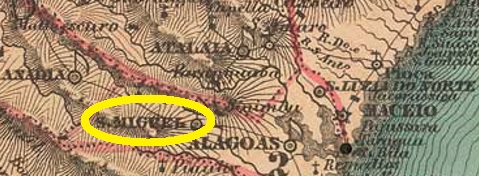
Villers de l’Ile Adam: Carta (…) das Provincias de Pernambuco, Alagoas e Sergipe, 1848
Another name: São Miguel
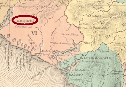
São Miguel dos Campos was a freguesia in the municipality of Alagoas (today: Deodoro), which became a villa in July 1832 and was declared a town in June 1864. The village is located about 50 km southwest of the provincial capital Maceió and had almost 20,000 inhabitants at the end of the Empire.
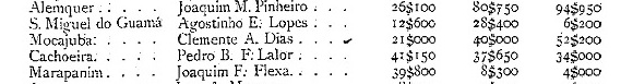
There are three creation years for the local post office, two of which are provided by Aldo Cardoso in his Contribuição para a História dos Correios de Alagoas (Maceió, 1969): June 1834 and 1842. On the other hand, Nova Monteiro writes in Administrações e Agencias Postaes do Brasil Imperio, (Brasil Filatelico/RJ, 1934-5; Reprint SPP 1994-1999) that there was a post office in São Miguel dos Campos since September 1855.
Two postmarks of the 19th century were found as double circles, the oldest of which is unfortunately difficult to read. SAL-0220b (Coll. José A. Junges) has the inscriptions (…) CAMPOS above and ALAGOAS below. The only copy has a date from 1870 in the centre. SAL-0220c (Coll. José A. Junges) has above the inscription S. MIGL. DOS CAMPOS, below is (ALAGOAS) now between brackets. Dates in the middle between 1890 and 1896.
Atlas do Imperio do Brasil, 1868
Anderer Name: São Miguel
São Miguel dos Campos war eine Freguesia im Município von Alagoas (heute: Deodoro), die bereits im Juli 1832 zur Villa aufstieg und im Juni 1864 zur Stadt erklärt wurde. Der Ort liegt gut 50 km südwestlich der Provinzhauptstadt Maceió und hatte am Ende des Kaiserreichs fast 20.000 Einwohner.
Drei Gründungsjahre fürs örtliche Postamt sind vorhanden, zwei davon liefert Aldo Cardoso in seiner Contribuição para a História dos Correios de Alagoas (Maceió, 1969): Juni 1834 und 1842. Auf der anderen Seite schreibt Nova Monteiro inAdministrações e Agencias Postaes do Brasil Imperio, (Brasil Filatelico/RJ, 1934-5; Reprint SPP 1994-1999), es gibt ein Postamt in São Miguel dos Campos seit September 1855.
Zwei Poststempel des 19. Jahrhunderts wurden als Doppelkreise gefunden, der älteste davon leider nur schwer leserlich. SAL-0220b (Samml. José A. Junges) hat die Inschriften (…) CAMPOS oben und ALAGOAS unten. Das einzige Exemplar hat ein Datum aus 1870 in der Mitte. SAL-0220c (Samml. José A. Junges) hat oben die Inschrift S. MIGL. DOS CAMPOS, unten ist (ALAGOAS) nun zwischen Klammern. Daten in der Mitte zwischen 1890 und 1896.
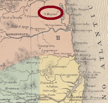
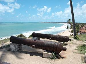
This village with the dramatic name São Miguel da Bahia da Traição (on the Bay of Treason) was already in 1762 a freguesia of Mamanguape, which was located about 90 km north of the provincial capital Parahyba (today João Pessoa). The betrayal refers to the French invaders in the 16th century, who were apparently better able to deal with the Indians than the Portuguese. The French also built a fortress there, of which today only a few cannons can be seen, which keep rusting peacefully on the beach. Only in December 1908 the place became a district of Mamaguape, and since January 1962 it is the municipality of Baía da Traição.
Photo: Marcelo
As can be read in the Postal Report (Relatorio Postal) for 1887, there has been a post office there since November 1882. So far, unfortunately, no postmark of the Empire has been seen.
Villiers de l’Ile Adam: Carta (…) das Provincias do Rio Grande do Norte e Parahyba
Anderer Name: Baía da Traição (1962)
Diese Ortschaft mit dem dramatischen Namen São Miguel da Bahia da Traição (an der Bucht des Verrats) war bereits 1762 eine Freguesia von Mamanguape, die ca. 90 km nördlich der Provinzhauptstadt Parahyba (heute João Pessoa) entfernt lag. Der Verrat bezieht sich auf die französischen Invasoren im 16. Jahrhundert, die offenbar besser als die Portugiesen mit den Indianern umgehen konnten. Die Franzosen haben auch dort eine Festung gebaut, von der heute nur noch ein paar Kanonen zu sehen sind, die friedlich am Strand vor sich hin rosten. Erst im Dezember 1908 steig der Ort zum Distrikt von Mamaguape, und seit Januar 1962 ist er der Município von Baía da Traição.
Foto: Marcelo
Wie im Postbericht (Relatorio Postal) für 1887 zu lesen ist, gibt es dort ein Postamt seit November 1882. Bisher wurde leider kein Poststempel des Kaiserreichs gesichtet.
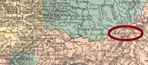
Other names: São Miguel e Almas dos Arrepiados, Araponga (1886)
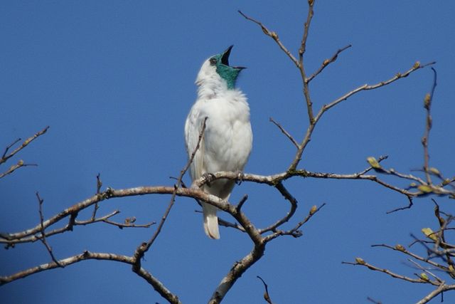
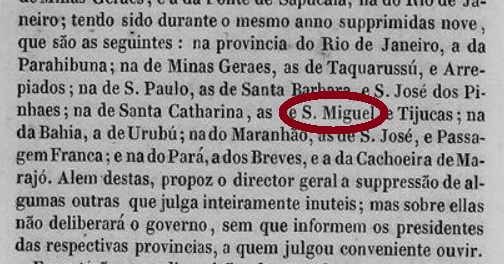
Since November 1826, this village was a district of Santa Rita do Turvo (today: Viçosa), which was called the São Miguel e Almas dos Arripiados (= St. Michael and Souls of the Feared) and was located about 170 km east of the provincial capital Ouro Preto. Since the name sounded very bizarre even for Brazilian conditions, it was changed to S. Miguel do Araponga in July 1886. Araponga is the name of three different neo-tropical bellbirds of the Family Cotingidae of South America:
Procnias Nudicollis (Photo: Ben Taverner, CC BY 2.0)
In December 1938, the place’s name was simplified to Araponga, and in December 1962 it became a municipality.
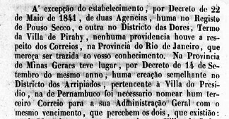
As Paula Sobrinho reports in Historia Postal de Minas Gerais (Belo Horizonte, 1997), there has been a post office there since September 1880. Nevertheless, new research has revealed that a post office was established there as early as September 1841, as confirmed by a ministerial report of that year:
Relatório do Ministério do Império, 1841
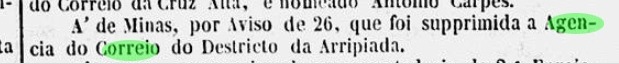
The post office was not closed until November 1846, as the capital’s press reported at the time:
Gazeta Official, 10.12.1846
This means there could still be postmarks from Arripiados on Bull’s-eyes.
The first known postmark SMG-2518a is the seal that can be seen in Paulo Ayres (Catalogo de Carimbos Brasil-Império, S. Paulo, 1937, 1942) on p. 145:
SMG-2518a (P. Ayres p. 145) 1880-1882ff
For imperial postmarks featuring Araponga see AMG-0110.
Villiers de l’Ile Adam: Carta (…) da Provincia de Minas Geraes, 1849
Textaktualisierung vom 9. Dezember 2022
Andere Namen: São Miguel e Almas dos Arrepiados, Araponga (1886)
Diese Ortschaft war seit November 1826 ein Distrikt von Santa Rita do Turvo (heute: Viçosa), der São Miguel e Almas dos Arripiados (= Skt. Michael und Seelen der Gefürchteten) hieß und ca. 170 km östlich der Provinzhauptstadt OuroPreto lag. Da der Name sogar für brasilianische Verhältnisse sehr skurril klang, wurde er im Juli 1886 zu S. Miguel do Araponga geändert.Araponga ist der Name von drei verschiedenen Glockenvögeln Sudamerikas der Familie Cotingidae, Gattung Procnias:
Procnias Nudicollis (Foto: Ben Taverner, CC BY 2.0)
Im Dezember 1938 wurde der Ortsname zu Araponga vereinfacht, und im Dezember 1962 stieg der Ort zum Município auf.
Wie Paula Sobrinho in História Postal de Minas Gerais (Belo Horizonte, 1997) berichtet, gibt es dort ein Postamt seit September 1880. Neue Recherchen haben dennoch ergeben, dass bereits im September 1841 ein Postamt dort ins Leben gerufen wurde, wie ein Ministerialbericht des Jahres bestätigt:
Relatório do Ministério do Império, 1841
Das Postamt wurde erst im November 1846 geschlossen, wie damals die Hauptstadtpresse meldete:
Gazeta Official, 10.12.1846
Das bedeutet, es könnten noch Poststempel aus Arripiados auf Ochsenaugen geben.
Der erste bekannte Poststempel SMG-2518a ist der Siegel, der in Paulo Ayres (Catálogo de Carimbos Brasil-Império, S. Paulo, 1937, 1942) auf S. 145 zu sehen ist:
J. M. Ribeiro Lisboa: Provincia de São Paulo, 1884
Text update of July 27, 2024
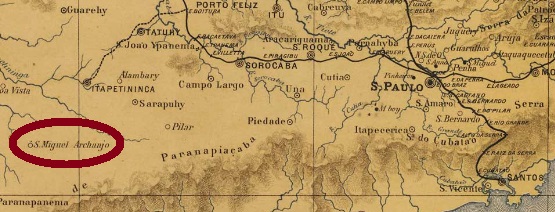
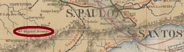
Other names: Fazenda Velha
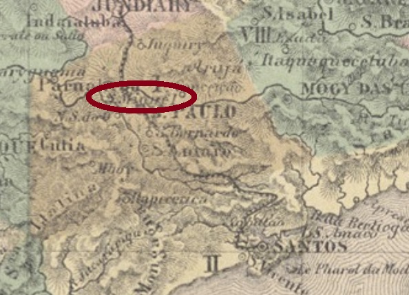
São Miguel Archanjo was originally called Fazenda Velha (Old Estate) and was located on the south bank of the Rio Turvo, a good 180 kilometres west of the provincial capital of São Paulo. The village was given its current name in May 1877 when it became a freguesia in the Município Itapetininga. Since April 1889, São Miguel Arcanjo (as it is spelt today) has been an independent município.
According to the list of imperial post offices (Tabella das Agencias do Correio do Imperio, Rio de Janeiro, 1885), there had been a post office there since 1876, when the town was still called Fazenda Velha. This is confirmed by the regional press:
Correio Paulistano, 05.01.1877
Two postmarks are known from the imperial era: The French type SSP-1210a (collect. Fuad Ferreira Fo.) and the presumably earlier double circle SSP-1210b (fig. Mário Celso Orsi Jr.).
SSP-1210a (FF) 1888SSP-1210b (MO) 1881Provincia de São Paulo, 1886
Textaktualisierung vom 27. Juli 2024
Andere Namen: Fazenda Velha
São Miguel Archanjo hieß ursprünglich Fazenda Velha (Altes Landgut) und liegt am Südufer des Rio Turvo, gut 180 km westlich der Provinzhauptstadt São Paulo. Im Mai 1877 erhielt der Ort seinen heutigen Namen, als er eine Freguesia im Município Itapetininga wurde. Seit April 1889 ist São Miguel Arcanjo (wie es heute geschrieben wird) ein eigenständiges Município.
Wie aus dem Verzeichnis der kaiserlichen Postämter (Tabella das Agencias do Correio do Imperio, Rio de Janeiro, 1885) hervorgeht, gab es dort seit 1876 ein Postamt, als der Ortsname noch Fazenda Velha lautete. Dies wird durch die regionale Presse bestätigt:
Correio Paulistano, 05.01.1877
Aus der Kaiserzeit sind zwei Poststempel bekannt: Der französische Typ SSP-1210a (Samml. Fuad Ferreira Fo.) und der vermutlich früher entstandene Doppelkreis SSP-1210b (Abb. Mário Celso Orsi Jr.).
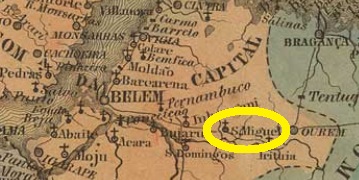
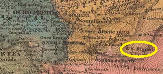
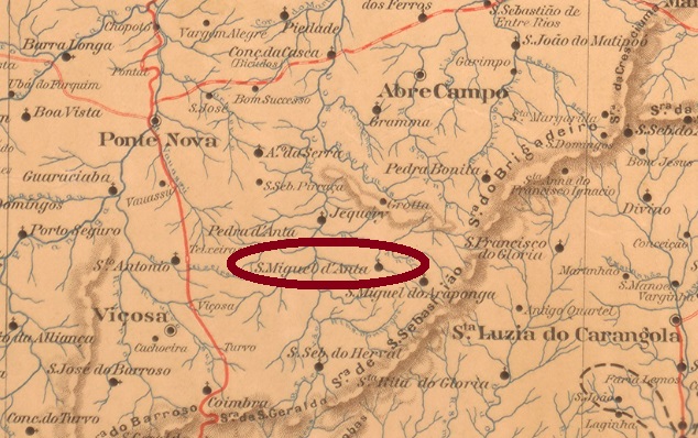
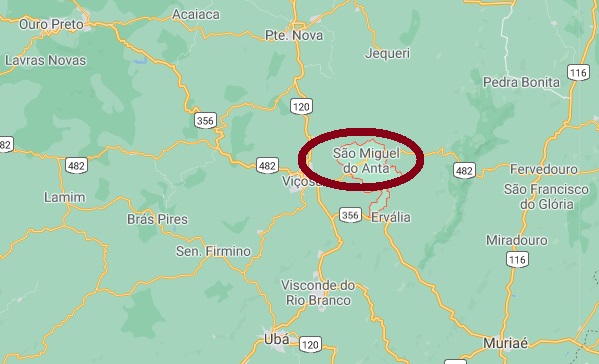
From July 1857, this was a district of Ponte Nova, located about 130 km southeast of the provincial capital Ouro Preto. In November 1866, the addition “do Anta” was added to the place name, recalling the original freguesia of Anta near Mariana. In November 1873, the district changed to the municipality of Santa Rita do Turvo (now Viçosa) and since November 1953 it has been an independent municipality.
As Paula Sobrinho writes in Historia Postal de Minas Gerais (Belo Horizonte, 1997), there has been a post office there since September 1880. Two early postmarks were found. SMG-2525a (Coll. José A. Junges) has a double circle with the inscription S. MIGUEL DO ANTA above and an ornament in diamond made of four small diamonds. One single copy was seen, with date of 1885 inside. SMG-2525b (Coll. José A. Junges) is probably already Republican: a double circle with the inscriptions S. MIGUEL DO ANTA above and (MINAS) below. Dates inside from 1898 to 1904.
Google Maps
Anderer Name: São Miguel
São Miguel war ab Juli 1857 ein Distrikt von Ponte Nova, der gut 130 km südöstlich der Provinzhauptstadt Ouro Preto lag. Im November 1866 kam der Zusatz „do Anta“ zum Ortsnamen dazu, in Anlehnung an die ursprüngliche Freguesia von Anta bei Mariana. Im November 1873 wechselte der Distrikt zur Gemeinde Santa Rita do Turvo (heute: Viçosa) und seit November 1953 ist er ein eigenständiger Município.
Wie Paula Sobrinho in História Postal de Minas Gerais (Belo Horizonte, 1997) schreibt, gibt es dort ein Postamt seit September 1880. Zwei frühe Poststempel wurden gefunden. SMG-2525a (Samml. José A. Junges) hat einen Doppelkreis mit der Inschrift S. MIGUEL DO ANTA oben und einem Ornament in Raute, das aus vier kleinen Rauten gebildet wird. Ein Exemplar vorhanden, mit Datum von 1885 in der Mitte. SMG-2525b (Samml. José A. Junges) ist wohl schon republikanisch: ein Doppelkreis mit den Inschriften S. MIGUEL DO ANTA oben und (MINAS) unten. Daten in der Mitte von 1898 bis 1904.
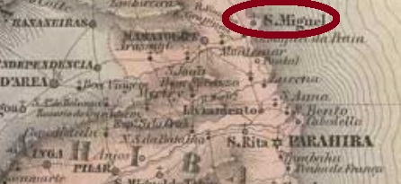
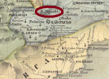
The present-day district of São Miguel Paulista is a suburb of São Paulo, situated less than 30 km east of the state capital, and has a reputation as a dangerous neighbourhood. Its history begins in the late 16th century, with the establishment of an Indian settlement under the care of the Jesuits. In 1622 the chapel was built in honour of the Archangel Michael, and in June 1779 the place became a freguesia. The district was appointed later, in February 1881, and since 1948 the district has been called São Miguel Paulista, probably to avoid confusion with S. Miguel Archanjo (SSP-1210).
According to the Imperial Mail Register (Tabella das Agencias do Correio do Imperio, Rio de Janeiro, 1885), there has been a post office there since 1872, and this is confirmed by the press from São Paulo:
Diário de São Paulo, 20 March 1872
However, the agency was closed sometime before 1880 because it is not listed in the Imperial Postal Guide (Guia Postal do Império) of that year. It was not possible to determine when the reopening took place, but since this post office reappeared in 1885 (see above), it will have happened in between.
Until now, no imperial postmark could be surely assigned to this village.
Villiers de l’Ile Adam: Carta (…) da Provincia de São Paulo, 1847
Anderer Name: São Miguel Paulista
Der heutige Distrikt von São Miguel Paulista liegt als Vorort von São Paulo knapp 30 km östlich der Landeshauptstadt und hat den Ruf, ein gefährlicher Viertel zu sein. Seine Geschichte beginnt im späten 16. Jahrhundert, mit der Gründung einer Indianersiedlung unter der Obhut der Jesuiten. 1622 wurde die Kapelle zu Ehren des Erzengels Michael erbaut, und im Juni 1779 wurde der Ort zur Freguesia. Die Ernennung zum Distrikt erfolgte erst später, im Februar 1881, und seit 1948 heißt der Distrikt São Miguel Paulista, wohl auch zum Unterschied zu S. Miguel Archanjo (SSP-1210).
Laut Verzeichnis der kaiserlichen Postämter (Tabella das Agencias do Correio do Imperio, Rio de Janeiro, 1885) gibt es dort ein Postamt seit 1872, und das bestätigt die Presse aus São Paulo:
Diário de São Paulo, 20. März 1872
Allerdings wurde die Agentur irgendwann vor 1880 geschlossen, da sie nicht im kaiserlichen Postführer (Guia Postal do Império) aufgelistet ist. Wann die Wiedereröffnung stattfand, konnte nicht ermittelt werden, aber da dieses Postamt wieder 1885 auftaucht (s.o.), wird es dazwischen passiert sein.
Bisher konnte kein Poststempel der Kaiserzeit dieser Ortschaft mit Sicherheit zugeordnet werden.
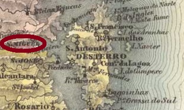
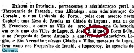
Other names: Sao João Evangelista de Biguassú, Guaporanga (1943)
See also Biguaçu (R. Koester: Carimbologia IV)
Like its namesake in the province of São Pedro do Rio Grande, this São Miguel of the neighbouring province of Santa Catarina has an eventful history. The settlement officially started in 1747, the village was located about 40 km northwest of the future capital Desterro (today Florianópolis) and became already in March 1833 a villa. Three descents to district followed: in July 1873 subordinated to Tijucas, in August 1886, to S. João Evangelista de Biguassu and most recently in April 1894, again to Biguassu (today written Biguaçu). In between, in April 1875 and 1888, the headquarters of a villa was in Sao Miguel. Since December 1943, the town has been called Guaporanga. The name has native American origin, describing a medicinal plant of the Myrtaceae family (Marlierea tomentosa, Cambess):
Photo: Patrick Soares (CC-BY-SA)
The postal history of this place is also turbulent and still has gaps. We do not yet know when this post office first opened, but it closed around 1846, as can be read in the Brazilian Yearbook (Annuario Politico, Historico e Estatistico do Brazil) for 1847:
1847 Annuario
Although the next opening of the post office was not announced until 1875 in the report of the provincial president, the similar report of January 1850 indirectly mentioned the existence of a post office in São Miguel:
Relatorio do Presidente da Provincia/SC, January 1850.
No postmark in the imperial era could be surely assigned to this village.
Villiers de l’Ile Adam: Carta (…) da Provincia de Santa Catharina, 1848
Andere Namen: São João Evangelista de Biguassú, Guaporanga (1943)
Siehe auch Biguaçu (R. Koester: Carimbologia IV)
Wie sein Namensvetter in der Provinz São Pedro do Rio Grande, auch dieser São Miguel der Nachbarprovinz Santa Catarina hat eine wechselvolle Geschichte. Die Siedlung startete offiziell im Jahr 1747, der Ort lag knapp 40 km nordwestlich der künftigen Hauptstadt Desterro (heute Florianópolis) und wurde bereits im März 1833 eine Villa. Es folgten drei Abstiege als Distrikt: im Juli 1873 zu Tijucas, im August 1886 S. João Evangelista de Biguassu und zuletzt im April 1894, nochmals zu Biguassu (heute Biguaçu geschrieben). Zwischendurch – nämlich im April 1875 und in 1888 – war São Miguel Hauptsitz einer Villa. Seit Dezember 1943 heißt der Ort Guaporanga. Der Name hat indianischen Ursprung, so heißt eine Medizinpflanze der Familie der Myrtaceae (Marlierea tomentosa, Cambess):
Foto: Patrick Soares (CC-BY-SA)
Auch die Postgeschichte dieses Orts ist turbulent und weist noch Lücken auf. Wir wissen noch nicht, wann dieses Postamt erstmals eröffnet hat, aber es hat um 1846 geschlossen, wie aus dem Brasilien-Jahrbuch (Annuario Politico, Historico e Estatistico do Brazil) für 1847 hervorgeht:
Annuario 1847
Obwohl die nächste Posteröffnung erst 1875 im Bericht des Provinzpräsidenten bekannt gegeben wurde, erwähnte der Bericht vom Januar 1850 indirekt das Vorhandensein eines Postamts in São Miguel:
Relatorio do Presidente da Provincia/SC, Januar 1850.
Kein Poststempel in der Kaiserzeit konnte bisher mit Sicherheit dieser Ortschaft zugeordnet werden.
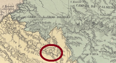
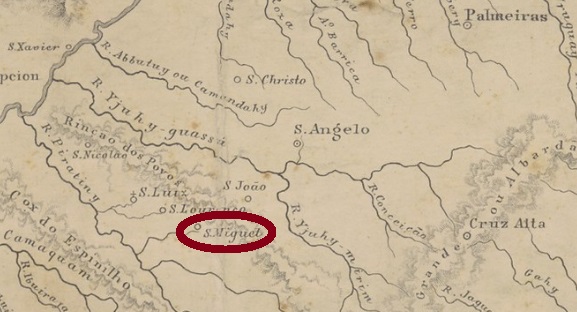
Other names: São Miguel Archanjo, São Miguel das Missões
This village is famous because the Jesuits have built there one of the seven mission settlements (Sete Povos das Misses) for the Indians of the Guarani tribe since the 17th century. After long-time assaults by the Bandeirantes from São Paulo and after many wars between Spaniards and Portuguese, Jesuits and Indians were their main victims, and today only ruins remain of that civilization, as a tourist attraction.
Only towards the end of the Empire was an orderly settlement possible again. The district of Santo Angelo was built in May 1881, located about 480 km northwest of the provincial capital Porto Alegre. The place grew so slowly that it only emancipated itself more than a century later, in April 1988, when the municipality of São Miguel das Missões.
According to the Imperial Mail Register (Tabella das Agencias do Correio do Imperio, Rio de Janeiro, 1885), there has been a post office there since 1881. However, there are so many D.Pedro editions from 1866 with the local cancel SRS-0365a (Coll. José A. Junges) that one wonders whether this agency was not in operation earlier. The cancel is a double circle with the inscriptions S. MIGUEL above and S. PEDRO DO SUL below. There was free space in the inner circle to enter the date by hand, which rarely happened, as the available copies (used until at least 1889) show.
Provincia de São Pedro do Rio Grande do Sul, 1877
Andere Namen: São Miguel Archanjo, São Miguel das Missões
Diese Ortschaft ist berühmt, da die Jesuiten dort seit dem 17. Jahrhundert einen der sieben Missionssitze (Sete Povos das Missões) für die Indianer des Guarani-Stamms gebaut haben. Nach den Plünderungen der Bandeirantes aus São Paulo und nach den vielen Kriegen zwischen Spaniern und Portugiesen waren Jesuiten und Indianer die Hauptleidtragenden, und heute sind nur noch Ruinen als touristische Attraktion übriggeblieben.
Erst gegen Ende des Kaiserreichs war wieder eine geordnete Siedlung möglich. Der Distrikt von Santo Angelo entstand im Mai 1881 und lag ca. 480 km nordwestlich der Provinzhauptstadt Porto Alegre entfernt. Der Ort wuchs so langsam, dass er sich erst über ein Jahrhundert später emanzipierte, im April 1988, als Município von São Miguel das Missões.
Laut dem Verzeichnis der kaiserlichen Postämter (Tabella das Agencias do Correio do Imperio, Rio de Janeiro, 1885) gibt es dort ein Postamt seit 1881. Allerdings sind so viele D. Pedro-Ausgaben von 1866 mit dem Ortsstempel SRS-0365a (Samml. José A. Junges) vorhanden, dass man sich fragen muss, ob diese Agentur nicht schon früher in Betrieb war. Der Stempel ist ein Doppelkreis mit des Inschriften S. MIGUEL oben und S. PEDRO DO SUL unten. Im Innenkreis war freier Raum, um das Datum per Hand einzutragen, was wohl selten passiert ist, wie die bis mindestens 1889 vorhandenen Exemplare zeigen.