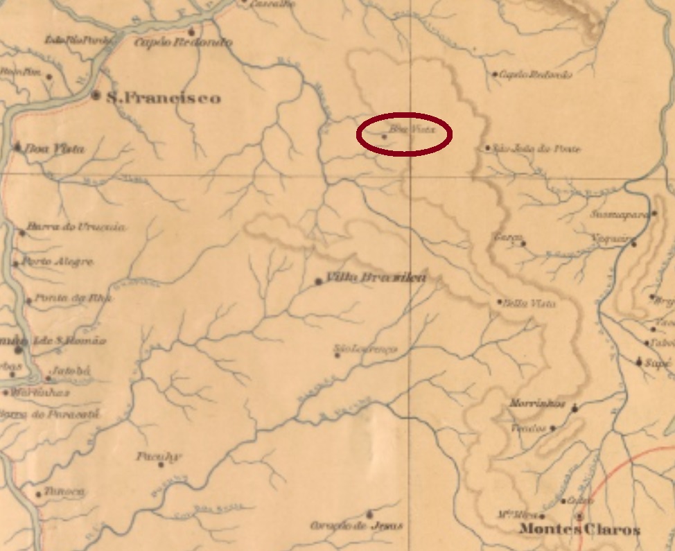
Santo Antonio da Boa Vista was since July 1850 a district of the municipality of São João da Ponte, situated over 600 km north of the provincial capital Ouro Preto. Since then, it has changed twice to other municipalities: in November 1877 to Sant’Anna de Contendas, and in September 1901 to Vila Brasília, before returning to São João da Ponte in December 1943.
According to Paula Sobrinho (História Postal de Minas Gerais, Belo Horizonte, 1997), the local post office was created in January 1883. No postal cancel of the Empire could be safely identified until now.
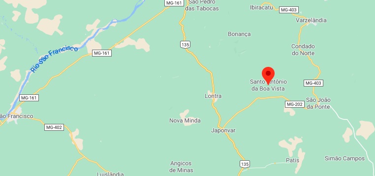
Google Maps
Anderer Name: Boa Vista de Montes Claros
Santo Antonio da Boa Vista war ab Juli 1850 ein Distrikt im Município von São João da Ponte, der über 600 km nördlich der Provinzhauptstadt Ouro Preto entfernt lag. Seitdem wechselte die Ortschaft zweimal zu anderen Gemeinden: im November 1877 zu Sant’Anna de Contendas und im September 1901 zu Vila Brasília, und kehrte zum ursprünglichen Município von São João da Ponte im Dezember 1943 endgültig zurück.
Wie Paula Sobrinho in seiner História Postal de Minas Gerais (Belo Horizonte, 1997) berichtet, entstand das örtliche Postamt im Januar 1883. Keine postalische Abstempelung von dort konnte bisher sicherlich identifiziert werden.
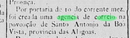
However, Aldo Cardoso (Contribuição para a História dos Correios de Alagoas, Maceió, 1969) states this agency was closed as soon as 1894. No cancel of the Empire has been found until now.
Google Maps
Buchtext-Aktualisierung von 12. November 2020
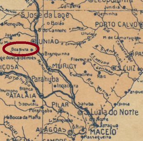
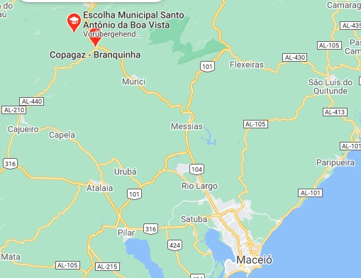
Santo Antonio da Boa Vista war ab März 1872 ein Distrikt im Município von Muricy, der an Ostufer des Flusses Mundaú, rund 90 km nordwestlich der Provinzhauptstadt Maceió entfernt lag. Im Mai 1962 wurde daraus ein Stadtteil des neulich gegründeten Município von Branquinha.
Laut Verzeichnis der kaiserlichen Postämter (Tabella das Agencias do Correio do Imperio) von 1885 gab es dort ab Juli 1884 ein Postamt, wie die Presse aus Rio bestätigen kann:
Diario do Brazil/RJ, 11. Juli 1884
Allerdings wurde die Agentur bereits 1894 geschlossen, wie Aldo Cardoso (Contribuição para a História dos Correios de Alagoas, Maceió, 1969) berichtet. Kein Poststempel des Kaiserreichs konnte bisher gefunden werden.
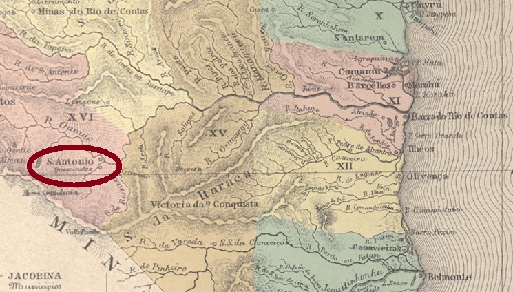
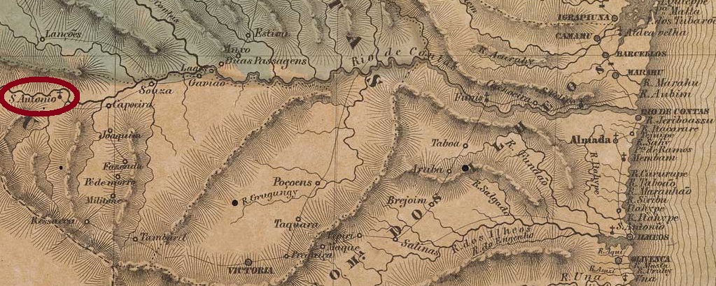
Santo Antonio da Barra was since May 1851 a district in the municipality of Caetité, situated round 650 km southwest of the province capital Salvador da Bahia. In June 1860 it ascended to a villa in own municipality, which was declared the town of Condeúba in June 1889. The name is a tupi-portuguese merge and shall mean well burning wood.
According to Nova Monteiro (Administrações e Agencias Postaes do Brasil Imperio, in Brasil Filatelico/RJ, 1934-5; Reprint SPP 1994-1999), the local post office was created in March 1864. Two ancient cancels were found. SBA-0685a was already presented by R. Koester (Carimbologia XIII): a French-type, with the inscription SANTO ANTONIO DA BARRA above and the typical star between parentheses below. The inner dates are usually missing and should have been written by hand. Found on stamps issued 1882-1884. SBA-0685b (Coll. FM) is possibly republican, for it was found with date 1895: a double circle with imprint S.A. DA BARRA above, dated at the centre.
Villiers de l’Ile Adam: Carta (…) da Provincia da Bahia, 1848
Buchtext-Aktualisierung vom 11. November 2020
Siehe auch Condeúba (R. Koester: Carimbologia XIII)
Santo Antonio da Barra war ab Mai 1851 ein Distrikt im Município von Caetité, der rund 650 km südwestlich der Provinzhauptstadt Salvador da Bahia entfernt lag. Im Juni 1860 wurde daraus eine Villa im eigenen Município, die zur Stadt Condeúba im Juni 1889 aufstieg. Dieser Ortsname ist ein tupi-portugiesiches Konstrukt, das gutes Brennholz bedeuten soll.
Laut Nova Monteiro (Administrações e Agencias Postaes do Brasil Imperio, in Brasil Filatelico/RJ, 1934-5; Reprint SPP 1994-1999) entstand das örtliche Postamt im März 1864. Zwei frühe Abstempelungen wurden gefunden. SBA-0685a war bereits durch R. Koester (Carimbologia XIII) vorgestellt: ein “Französischer-Typ” mit der Inschrift SANTO ANTONIO DA BARRA oben und dem typischen Stern zwischen Klammern unten. Die Daten in Inneren fehlen meistens, die sollten wohl per Hand eingetragen werden. Gefunden auf Marken, die 1882-1884ff ausgegeben wurden. SBA-0685b (Samml. FM) ist möglicherweise bereits republikanisch, da das einzige Exemplar ein Datum von 1895 aufweist. Der Stempel zeigt einen Doppelkreis mit der Inschrift S.A. DA BARRA oben, dazu Datum in der Mitte.
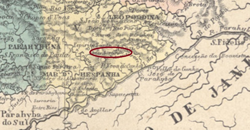
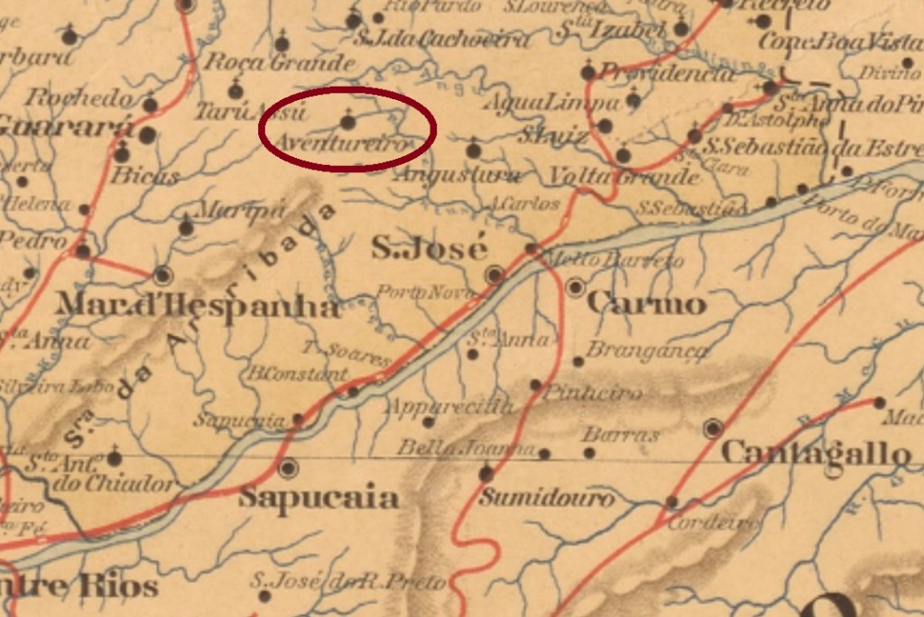
The Aventureiro (= Adventurer) is a small brook in southern Minas Gerais which in May 1852 gave its name to the district of Santo Antonio, situated in the municipality of Mar d’Hespanha (= Spanish Sea), round 300 km south of the provincial capital Ouro Preto. In September 1923 the toponym was simplified to Aventureiro, which in December 1938 passed as a district to Além Parahyba. The political emancipation came in December 1962, when the original name Santo Antonio do Aventureiro also returned.
According to Paula Sobrinho (História Postal de Minas Gerais, Belo Horizonte, 1997), the local post office was created in September 1877. The only known imperial cancel is SMG-3015a (Coll. José A. Junges). It occurs in black and violet and presents a double circle with the inscription S. ANTONIO DO AVENTUREIRO above and a cross-like ornament below, whose every wing is a small diamond. The dates at the centre were found for the period 1885-1906.
Estado de Minas Geraes, 1910
Anderer Name: Aventureiro
Der Aventureiro (= Abenteurer) ist ein kleiner Bach im südlichen Minas Gerais, der im Mai 1852 seinen Namen an den Distrikt von Santo Antonio gab, der im Município von Mar d’Hespanha (= Spanische See) lag, rund 300 km südlich der ehemaligen Provinzhauptstadt Ouro Preto entfernt. Im September 1923 wurde der Ortsname zu Aventureiro vereinfacht, und der Ort wechselte im Dezember 1938 zum Município von Além Parahyba. Die politische Unabhängigkeit der Gemeinde kam im Dezember 1962, als auch die ursprüngliche Bezeichnung Santo Antonio do Aventureiro zurückkehrte.
Laut Paula Sobrinho (História Postal de Minas Gerais, Belo Horizonte, 1997) entstand das örtliche Postamt im September 1877. Der einzig bekannte Stempel der Kaiserzeit ist SMG-3015a (Samml. José A. Junges). Er kommt in schwarz und violett vor und zeigt einen Doppelkreis mit der Inschrift S. ANTONIO DO AVENTUREIRO oben und einen Ornament in Kreuzform unten, bei dem jeder Flügel eine kleine Raute ist. Die Daten in der Mitte wurden für den Zeitraum 1885-1906 ermittelt.
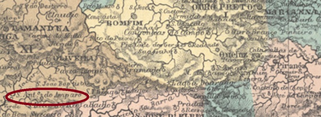
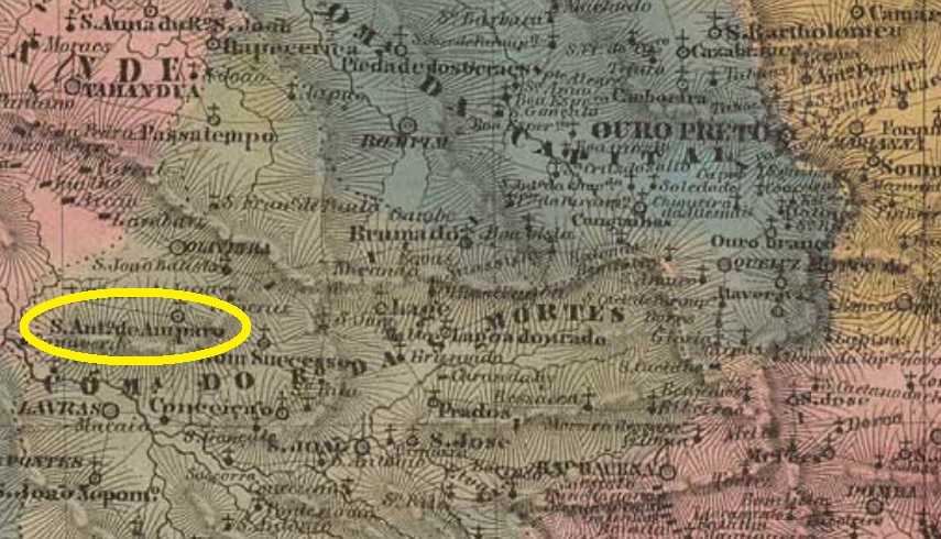
Santo Antonio do Amparo was since July 1832 a freguesia in the municipality of Oliveira, situated ca. 230 km southwest of the provincial capital Ouro Preto. In September 1884 it ascended to a villa in own municipality, but it was degraded back to a district in January 1891, now of the municipality of Bom Sucesso. The definitive political emancipation returned only in December 1938.
According to Paula Sobrinho (História Postal de Minas Gerais, Belo Horizonte, 1997), the local post office was created in January 1881. The only known post cancel in the Empire is SMG-3010a (Coll. José A. Junges): a double circle with the imprint S. ANTONIO DO AMPARO above and a diamond ornament below, dotted inside. The dates at the centre were found for the period 1885-1894.
Villiers de l’Ile Adam: Carta (…) da Provincia de Minas Geraes, 1848
Santo Antonio do Amparo war ab Juli 1832 eine Freguesia im Município von Oliveira, die ca. 230 km südwestlich der Provinzhauptstadt Ouro Preto entfernt lag. Im September 1884 wurde daraus eine Villa im eigenen Município, aber schon im Januar 1891 wurde sie zum Distrikt zurück gestuft, diesmal im Município von Bom Sucesso. Erst im Dezember 1938 erhielt Santo Antonio do Amparo die endgültige politische Autonomie als Gemeinde.
Laut Paula Sobrinho (História Postal de Minas Gerais, Belo Horizonte, 1997) entstand das örtliche Postamt im Januar 1881. Der bisher einzige Poststempel der Kaiserzeit ist SMG-3010a (Samml. José A. Junges): ein Doppelkreis mit der Inschrift S. ANTONIO DO AMPARO oben und einem rautenförmigen Ornament unten, das einen Punkt enthält. Die Daten in der Mitte entstammen dem Zeitraum 1885-1894.
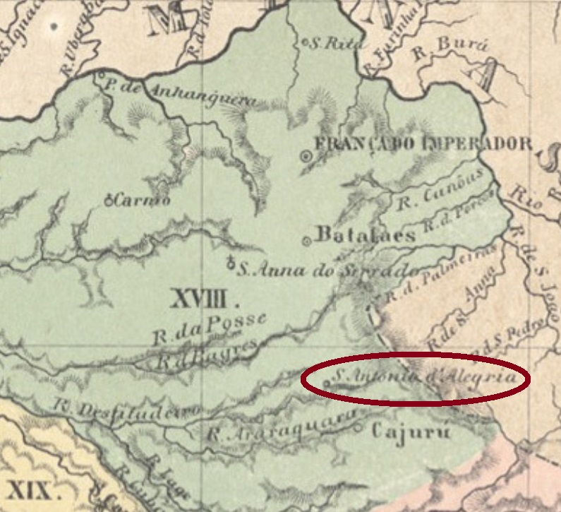
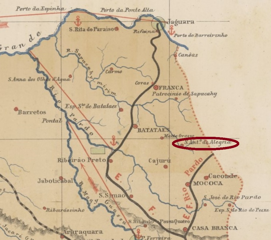
Santo Antonio da Alegria was originally the Cuscuzeiro Chapel, which became in April 1873 a freguesia of the municipality of Cajuru, situated over 300 km north of the provincial capital São Paulo. In March 1885 it ascended to a villa, which was made a town in December 1906.
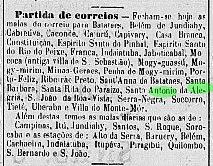
According to the Imperial Mail Register (Tabella das Agencias do Correio do Imperio) of 1885, the local post office was created in 1856, but such an early date might be a misprint. Instead, the earliest mention of a postal route through Santo Antonio da Alegria was published in August 1875 in the São Paulo press:
Correio Paulistano, August 3, 1875
This would mean the post office was created shortly before. Only one imperial cancel was found to date, whose left side is unfortunately missing: SSP-1315b (Coll. José A. Junges) has a double circle with the inscription (S.A. DA) ALEGRIA above and a four-leaf-clover ornament below. Both existing examples are dated 1889.
Mappa da Provincia de São Paulo, 1886
Santo Antonio da Alegria war ursprünglich die Kapelle von Cuscuzeiro, die im April 1873 zu einer Freguesia des Municipio von Cajuru erhoben wurde und über 300 km nördlich der Provinzhauptstadt São Paulo entfernt lag. Im März 1885 stieg sie zur Villa, und im Dezember 1906 zur Stadt auf.
Laut Verzeichnis der kaiserlichen Postämter (Tabella das Agencias do Correio do Imperio) von 1885, das örtliche Postamt ist aus dem Jahr 1856, aber dieses frühe Datum mag ein Druckfehler sein. Stattdessen findet man die früheste Erwähnung einer Postroute durch Santo Antonio da Alegria im August 1875 in der Presse von São Paulo:
Correio Paulistano, 3. August 1875
Möglicherweise entstand die Postagentur kurz vorher. Nur eine Abstempelung der Kaiserzeit war zu finden, wobei hier die linke Seite fehlt: SSP-1315b (Samml. José A. Junges) hat einen Doppelkreis mit der Inschrift (S.A. DA) ALEGRIA oben und einem Ornament in Form eines vierblättrigen Kleeblatts unten. Beide vorhandenen Exemplare sind aus dem Jahr 1889.
Other names: Rerituba, Santo Antonio de Lisboa (1948)
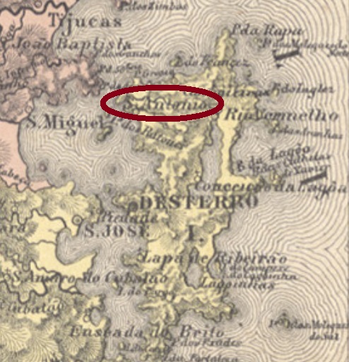
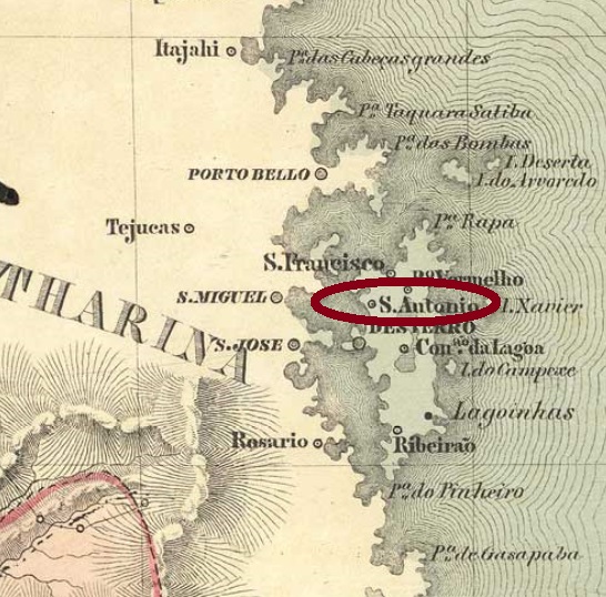
This Santo Antonio on the island of Santa Catarina was since January 1809 a North Bay district of the later provincial capital Desterro, situated round 20 km away from it. In December 1943 it had the name changed to Rerituba, a tupi-guarani word that means plenty of oysters. The new toponym became by no means popular, and five years later the district received the actual denomination Santo Antonio de Lisboa.
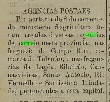
According to the local press, the post office was created in March 1884:
Jornal do Commercio, March 14, 1884
No postal cancel from the empire has appeared until now.
Villiers de l’Ile Adam: Carta (…) da Provincia de Santa Catharina, 1847
Andere Namen: Rerituba, Santo Antonio de Lisboa (1948)
Dieser Santo Antonio auf der Santa Catarina Insel war ab Januar 1809 ein Distrikt an der Nordbucht besagter Insel, der ca. 20 km weg von der späteren Provinzhauptstadt Desterro lag. Im Dezember 1943 der Name wechselte zu Rerituba, ein Begriff der tupi-guarani-Sprache, der etwa Austernreichtum bedeutet. Dieser Ortsname hat sich nicht durchgesetzt, und fünf Jahre später bekam der Distrikt die aktuelle Bezeichnung Santo Antonio de Lisboa.
Wie die Ortspresse berichtet, entstand das lokale Postamt im März 1884:
Jornal do Commercio, 14. März 1884
Keine postalische Abstempelung der Kaiserzeit war bisher zu sehen.
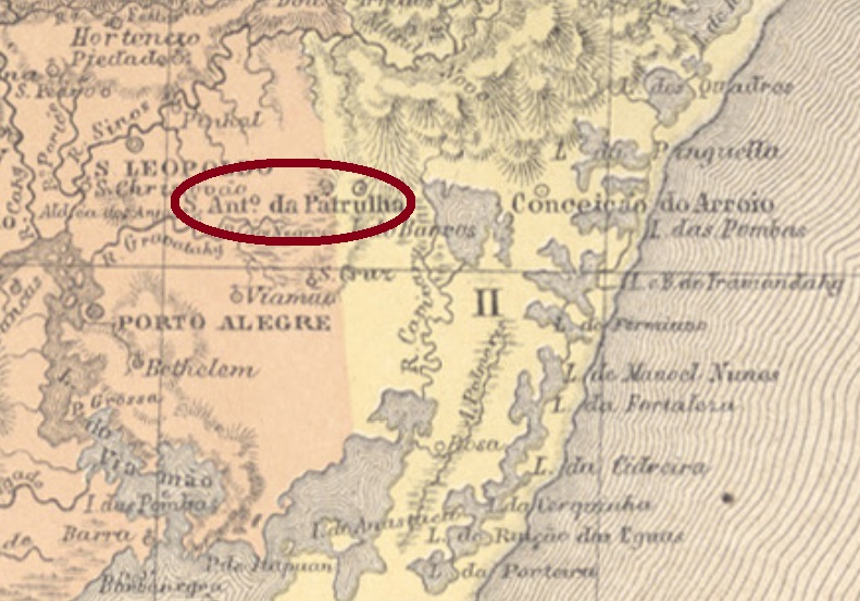
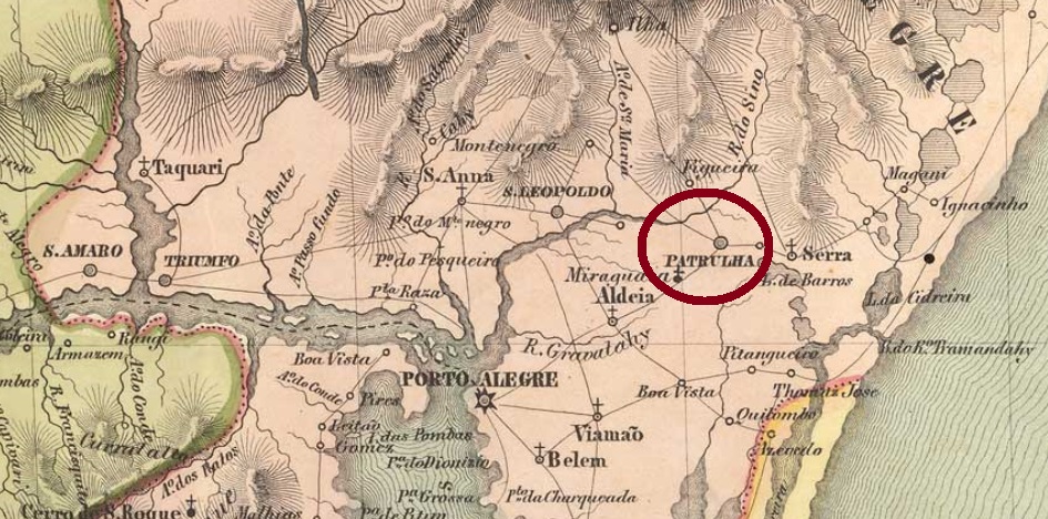
This locality has imperial cancels with slightly modified legends. Therefore, both variants will be presented together here. The freguesia of Santo Antonio da Guarda Velha was founded in 1760, ca. 80 km east of the later provincial capital Porto Alegre, and subordinated to Viamão. It was declared the district of Santo Antonio da Patrulha in October 1795, which ascended to a villa in November 1809. In December 1944 the official name was simplified to Santo Antonio, but in September 1977 the toponym Santo Antonio da Patrulha returned definitively.
The earliest cancel, SRS-0615a, was found on Bull’s Eyes and used at least until 1866, but has probably a pre-philatelic origin, as presented by Henrique B. Ferreira in his Catálogo ilustrado dos carimbos sobre os olhos-de-boi (4th. ed., Porto Alegre, 2017):
SRS-0615a (apud Henrique B. Ferreira, op. cit.)
It was followed by SRS-0420a (Coll. José A. Junges): a double circle with the inscription S. A. DA PATRULHA above and the date at the centre. Only two exemplars seen, both of 1879.
Paulo Ayres (Catálogo de Carimbos Brasil-Império, S. Paulo, 1937, 1942) also shows a mute cancellation with #55, which we believe to refer to this locality:
P. Ayres (op. cit.) #55Villiers de l’Ile Adam: Carta (…) da Provincia de São Pedro do Sul
Diese Ortschaft hat Poststempel aus der Kaiserzeit, deren Texte leichte Veränderungen aufweisen. Darum werden beide Varianten hier zusammen vorgestellt. Die Freguesia von Santo Antonio da Guarda Velha wurde 1760 bei Viamão gegründet und lag ca. 80 km östlich der späteren Provinzhauptstadt Porto Alegre entfernt. Im Oktober 1795 wurde daraus der Distrikt von Santo Antonio da Patrulha, der im November 1809 zur Villa aufstieg. Im Dezember 1944 wurde der offizielle Name zu Santo Antonio vereinfacht, bevor im September 1977 der alte Ortsname Santo Antonio da Patrulha endgültig zurückkehrte.
Wir haben zwei Entstehungsjahre fürs örtliche Postamt gefunden. Laut Nova Monteiro (Administrações e Agencias Postaes do Brasil Imperio, in Brasil Filatelico/RJ, 1934-5; Reprint SPP 1994-1999) öffnete die Agentur erstmals im Oktober 1831. Das Verzeichnis der kaiserlichen Postämter (Tabella das Agencias do Correio do Imperio) von 1885, andererseits, listet das Postamt ab 1874, wahrscheinlich ein Jahr der Wiedereröffnung.
Der früheste Stempel, SRS-0615a, wurde auf Ochsenaugen bis zumindest 1866 benutzt, hat aber womöglich einen Vorphila-Ursprung. Das Bild stammt aus Henrique B. Ferreiras Catálogo ilustrado dos carimbos sobre os olhos-de-boi (4. Auflage, Porto Alegre, 2017):
SRS-0615a (apud Henrique B. Ferreira, op. cit.)
Ihm folgte SRS-0420a (Samml. José A. Junges): ein Doppelkreis mit der Inschrift S. A. DA PATRULHA oben und dem Datum in der Mitte. Nur zwei Exemplare wurden gesichtet, beide aus 1879.
Paulo Ayres (Catálogo de Carimbos Brasil-Império, S. Paulo, 1937, 1942) zeigt auch einen stummen Stempel unter Nr.55, den wir auch dieser Ortschaft zuschreiben würden:
Arthur D. Ribeiro: Mappa do Rio Grande do Norte, 1923
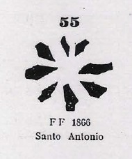
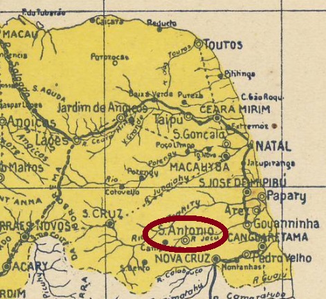
Santo Antonio was from June 1886 on a district of the municipality of Goianinha, situated round 80 km southwest of the provincial capital Natal. In July 1890 it ascended to a villa and received an own municipality in January 1892.
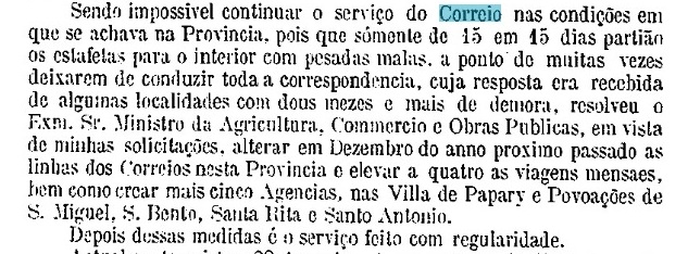
According to theImperial Mail Register (Tabella das Agencias do Correio do Imperio) of 1885, a local post office was created as early as 1836. This is probably a misprint, given that neither postal records nor cancels exist from a time up to fifty years before the village became a district. Instead, in May 1875 the creation of a postal agency in Santo Antonio in December 1874 was reported by the province president:
Relatorio do Presidente da Provincia/RN, May 1875
No postmark from the Empire could be safely identified until now.
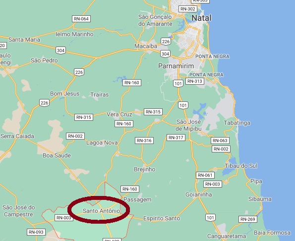
GoogleMaps
Santo Antonio war ab Juni 1886 ein Distrikt im Municipio von Goianinha und lag rund 80 km südwestlich der Provinzhauptstadt Natal entfernt. Im Juli 1890 stieg er zur Villa auf, im Januar 1892, zum eigenen Município.
Laut Verzeichnis der kaiserlichen Postämter (Tabella das Agencias do Correio do Imperio) von 1885 gab es dort bereits ab 1836 ein Postamt. Das dürfte ein Druckfehler sein (oder die Postagentur war von kurzer Dauer), da es keine weiteren Spuren von Postbetrieb dort aus der Zeit gab, 50 Jahre bevor Santo Antonio zum Distrikt erklärt wurde. Stattdessen meldete der Provinzpräsident in seinem Bericht vom Mai 1875 die Gründung eines Postamts in Santo Antonio im Dezember 1874:
Relatorio do Presidente da Provincia/RN, Mai 1875
Keine Poststempel der Kaiserzeit konnten bisher mit Sicherheit ermittelt werden.
Other names: Santo Antonio do Surubim, Santo Antonio de Campo Maior
See also Campo Maior (Koester: Carimbologia VIII)
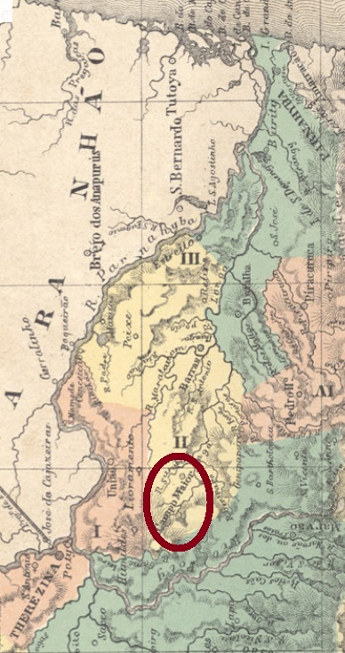
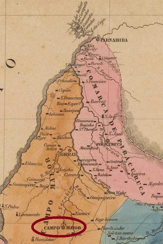
The long list of the villages named Santo Antonio in imperial Brazil starts in the Piauí province. The parish of Santo Antonio do Surubim (= St. Anthony of the Catfish) was established in June 1761 as the second one in Piauí, situated over 350 km north of the later provincial capital Oeiras. In August 1762 it was the main location of the villa and municipality of Campo Maior, which ascended to a town in December 1889.
According to R. Koester (Carimbologia VIII) the local post office was created in 1876, but he had found no imperial cancel featuring Campo Maior. On the other hand, one early cancellation with Santo Antonio was found, despite the later date of 1894: SPI-0160b (Coll. FM) has a double circle with the inscriptions S. ANTONIO above and (PIAUHY) below. At the centre, the cancellation date of January 1893 was corrected by hand to 1894.
Villiers de l’Ile Adam: Carta (…) da Provincia do Piauhy, 1850
Andere Namen: Santo Antonio do Surubim, Santo Antonio de Campo Maior
Siehe auch Campo Maior (Koester: Carimbologia VIII)
Die lange Auflistung der brasilianischen Ortschaften des Kaiserreichs, die Santo Antonio hießen, beginnt in der Provinz Piauí. Die Pfarrei von Santo Antonio do Surubim (= Hl. Antonius des Welses) war im Juni 1761 die zweite Freguesia, die in Piauí errichtet wurde und lag über 350 km nördlich der späteren Provinzhauptstadt Oeiras entfernt. Im August 1762 wurde sie der Sitz des neuen Município von Villa de Campo Maior, und stieg im Dezember 1889 zur Stadt auf.
R. Koester berichtet in seiner Carimbologia VIII, das örtliche Postamt wurde 1876 errichtet. Er konnte aber kein Poststempel mit Campo Maior finden. Dafür konnte ein früher Stempel für Santo Antonio ermittelt werden, datiert allerdings erst von 1894: SPI-0160b (Samml. FM) hat einen Doppelkreis mit den Inschriften S. ANTONIO oben und (PIAUHY) unten. Das Stempeldatum vom Januar 1893 in der Mitte wurde nachträglich per Hand auf 1894 korrigiert.