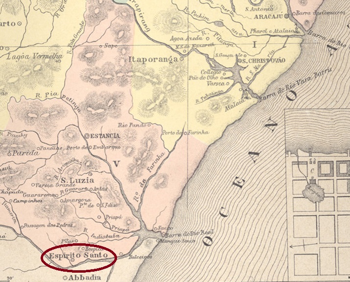
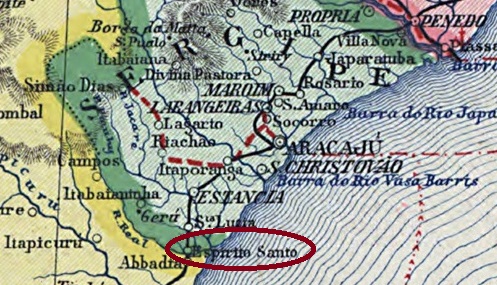
Other names: Espirito Santo do Rio Real, Indiaroba (1943)
The Freguesia do Espirito Santo, founded in March 1841, belonged to the Vila de Estância and was located on the north bank of the Rio Real on the provincial border with Bahia, 100 kilometres south of the later capital Aracaju. Five years later it was elevated to Vila do Espirito Santo do Rio Real and since December 1943 the município has been called Indiaroba. The term comes from the Tupi-Guarani and means seed of the Indaiá palm.
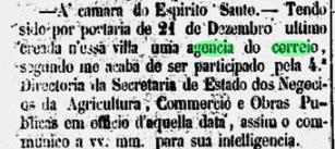
Nova Monteiro writes in Administrações e Agencias Postaes do Brasil Imperio (Brasil Filatelico/RJ, 1934-5; reprint SPP 1994-1999) that there has been a post office there since December 1861. This is confirmed by the regional press:
Correio Sergipense, 06.01.1862
Unfortunately, no imperial postmark has yet been assigned to this place with certainty.
Carta da Republica dos Estados Unidos do Brazil, 1892
Andere Namen: Espirito Santo do Rio Real, Indiaroba (1943)
Die im März 1841 gegründete Freguesia do Espirito Santo gehörte zur Vila de Estância und lag am Nordufer des Rio Real an der Provinzgrenze zu Bahia, 100 km südlich der späteren Hauptstadt Aracaju. Fünf Jahre später erfolgte die Erhebung zur Vila do Espirito Santo do Rio Real und seit Dezember 1943 heißt der Município Indiaroba. Der Begriff stammt aus dem Tupi-Guarani und bedeutet Samen der Indaiá-Palme.
Nova Monteiro schreibt in Administrações e Agencias Postaes do Brasil Imperio (Brasil Filatelico/RJ, 1934-5; Reprint SPP 1994-1999), dass es dort seit Dezember 1861 ein Postamt gab. Dies wird von der regionalen Presse bestätigt:
Correio Sergipense, 06.01.1862
Leider konnte bisher kein kaiserlicher Poststempel mit Sicherheit diesem Ort zugeordnet werden.
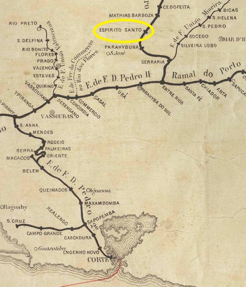
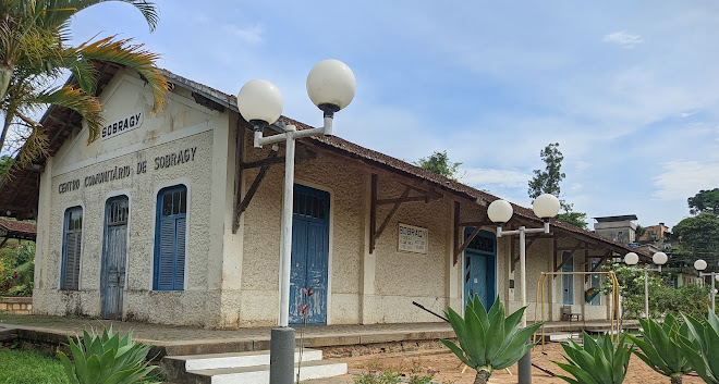
Espirito Santo railway station was opened in October 1875 by the E.F.D. Pedro II railway company (Central Line) and is located on the west bank of the Paraibuna in the Município Juiz de Fora, 250 km south of the provincial capital Ouro Preto. In July 1881, the station was renamed Sobragy in honour of Bento José Ribeiro Sobragy, who ruled the E.F.D. Pedro II for two terms.
The railway line was transferred to the E.F. Central d Brasil in 1889 and belonged to Rede Ferroviária Federal S.A. (estacoesferroviarias.com.br) from 1975 until its closure in 1996. Today, the tracks are still in place and the station building serves the municipality as a multi-purpose hall.
In 2023 (Photo: Catarina Gonçalves, on Google Maps)
The area around the railway station belonged to the Freguesia de Vargem Grande from September 1882 and to the Distrito de Ibitiguara from December 1943. Since November 1962, it has belonged to the Município de Belmiro Braga.
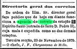
According to the Rio press, there was a railway station post office from November 1875:
Diario do Rio de Janeiro, 23/11/1875
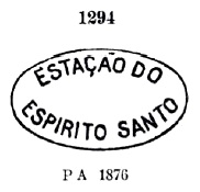
R. Koester gives the year 1876 in Carimbologia XVIII, which could well correspond to the start of operations of the post office. The oldest postmark is EMG-1130a, which was given the no. 1294 by Paulo Ayres (Catálogo de Carimbos Brasil-Império, S. Paulo, 1937, 1942):
EMG-1130a (P.A. 1294) 1875-1876ff
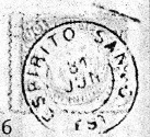
This was followed by EMG-1130b (fig. R. Koester, op. cit.), which also occurs in blue:
EMG-1130b (RK) 1877-1883ff
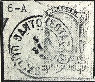
At the end of the Empire, when the station had long been called Sobragy, there was another stamp with the old name: EMG-1130c (fig. R. Koester), also in blue:
EMG-1130c (RK) 1885-1890Estações (…)do Rio de Janeiro, São Paulo e Minas Geraes, 1880
Andere Namen: Sobragy (1881)
Der Bahnhof Espirito Santo wurde im Oktober 1875 von der Eisenbahngesellschaft E.F.D. Pedro II (Central-Linie) eröffnet und liegt am Westufer des Paraibuna im Município Juiz de Fora, 250 km südlich der Provinzhauptstadt Ouro Preto. Im Juli 1881 wurde der Bahnhof in Sobragy umbenannt, zu Ehren von Bento José Ribeiro Sobragy, der die E.F.D. Pedro II während zwei Amtszeiten regierte.
Die Bahnlinie ging 1889 an die E.F. Central d Brasil über und gehörte von 1975 bis zu ihrer Schließung 1996 der Rede Ferroviária Federal S.A. (estacoesferroviarias.com.br). Heute sind die Gleise noch vorhanden, das Bahnhofsgebäude dient der Gemeinde als Mehrzweckhalle.
2023 (Foto: Catarina Gonçalves, auf Google Maps)
Das Gebiet um den Bahnhof gehörte ab September 1882 zur Freguesia de Vargem Grande und ab Dezember 1943 zum Distrito de Ibitiguara. Seit November 1962 gehört es zum Município de Belmiro Braga.
Wie die Presse von Rio berichtete, gab es ab November 1875 ein Bahnhofspostamt:
Diario do Rio de Janeiro, 23.11.1875
R. Koester gibt das Jahr 1876 in Carimbologia XVIII an, was wohl dem Betriebsbeginn des Postamtes entsprechen könnte. Der älteste Stempel ist EMG-1130a, der von Paulo Ayres (Catálogo de Carimbos Brasil-Império, S. Paulo, 1937, 1942) die Nr. 1294 erhielt:
EMG-1130a (P.A. 1294) 1875-1876ff
Es folgte EMG-1130b (Abb. R. Koester, op. cit.), der auch in blau erhältlich ist:
EMG-1130b (RK) 1877-1883ff
Am Ende des Kaiserreichs, als der Bahnhof längst Sobragy hieß, gab es noch einen weiteren Stempel mit dem alten Namen: EMG-1130c (Abb. R. Koester), ebenfalls in blau vorkommend:
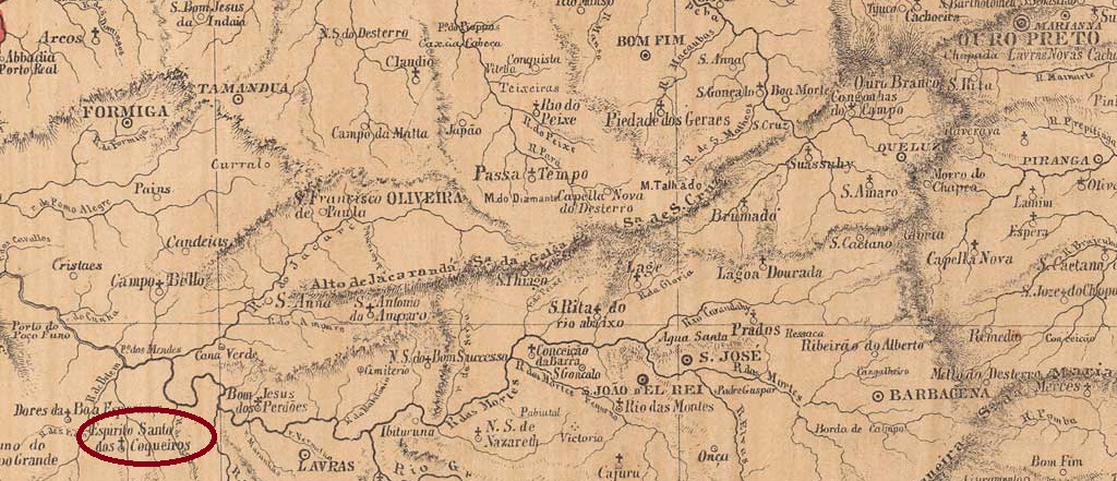
Other names: Espirito Santo dos Sertões e Sapê, Coqueiral (1923)
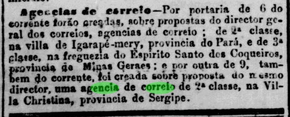
The settlement was originally called Arraial do Espírito Santo dos Sertões e Sapê and in 1846 became the Distrito do Espírito Santo dos Coqueiros on the south bank of the João Borges, 310 km south-west of the provincial capital Ouro Preto. In May 1855, it became the Freguesia do Divino Espírito Santo, which belonged to the Vila de Dores da Boa Esperança. In September 1923 it was renamed Coqueiral, which since December 1948 has been an independent municipality.
R. Koester writes in Carimbologia XVIII that there had been a post office there since October 1882. This is confirmed by the press in Rio:
Jornal do Commercio/RJ, 11 Oct. 1882
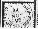
The imperial postmark is EMG-1150a (fig. R. Koester, op. cit.):
EMG-1150a (RK) 1890Atlas do Imperio do Brasil, 1868
Andere Namen: Espirito Santo dos Sertões e Sapê, Coqueiral (1923)
Die Siedlung hieß ursprünglich Arraial do Espírito Santo dos Sertões e Sapê und wurde 1846 zum Distrito do Espírito Santo dos Coqueiros am Südufer des João Borges, 310 km südwestlich der Provinzhauptstadt Ouro Preto. Im Mai 1855 wurde daraus die Freguesia do Divino Espírito Santo, die zur Vila de Dores da Boa Esperança gehörte. Im September 1923 erfolgte die Umbenennung in Coqueiral, seit Dezember 1948 ist Coqueiral ein eigenständiges Municipio.
R. Koester schreibt in Carimbologia XVIII, dass es dort seit Oktober 1882 ein Postamt gab. Dies wird von der Presse in Rio bestätigt:
Jornal do Commercio/RJ, 11.10.1882
Der kaiserliche Poststempel ist EMG-1150a (Abb. R. Koester, op. cit.):
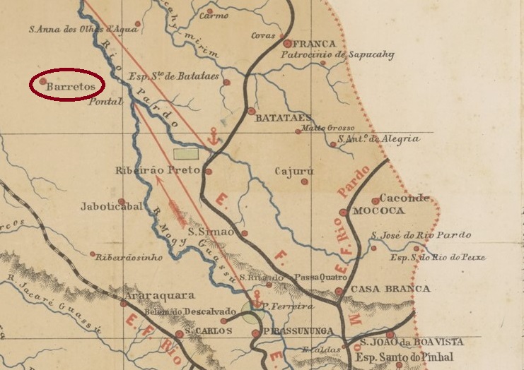
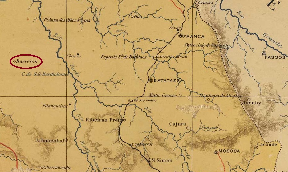
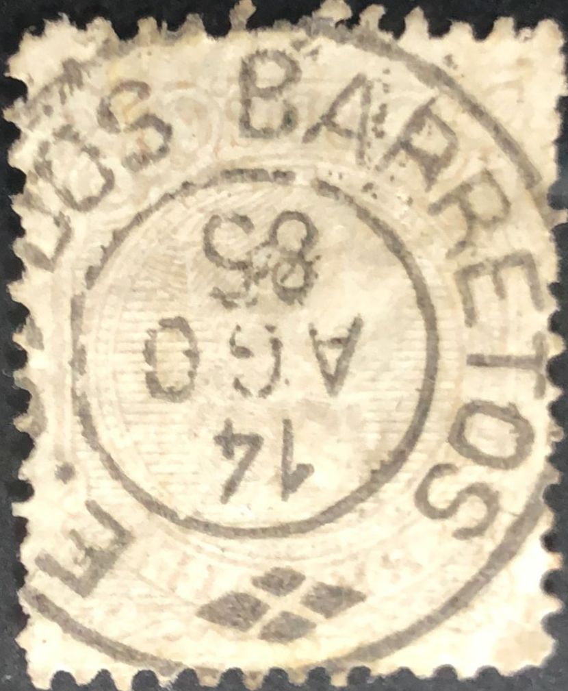
The Chapel Divino Espirito Santo dos Barretos was built in 1849 on the north bank of the Pitangueiras, 420 kilometres north of the provincial capital of São Paulo. In April 1874, the village was elevated to a freguesia of Vila de Jaboticabal, in March 1885 to a vila and in January 1897 to a town. The simplified place name Barretos has been used since November 1906.
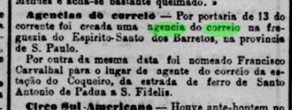
The list of imperial post offices (Tabella das Agencias do Correio do Imperio, Rio de Janeiro, 1885) shows that there had been a post office since 1883. This is confirmed by the press in Rio:
Jornal do Commercio/RJ 15/12/1883
However, R. Koester in Carimbologia XVIII gives 1884, presumably the year in which the agency began operating.
The only imperial postmark to date is ESP-0500a (fig. Robson Peniche):
ESP-0500a (RP) 1884-1887J. M. Ribeiro Lisboa: Provincia de São Paulo, 1884
Andere Namen: Barretos (1906)
1849 wurde die Capela do Divino Espirito Santo dos Barretos am Nordufer des Pitangueiras, 420 km nördlich der Provinzhauptstadt São Paulo, errichtet. Im April 1874 wurde der Ort zur Freguesia der Vila de Jaboticabal, im März 1885 zur Vila und im Januar 1897 zur Stadt erhoben. Seit November 1906 wird der vereinfachte Ortsname Barretos verwendet.
Aus dem Verzeichnis der kaiserlichen Postämter (Tabella das Agencias do Correio do Imperio, Rio de Janeiro, 1885) geht hervor, dass es seit 1883 ein Postamt gab. Dies wird von der Presse in Rio bestätigt:
Jornal do Commercio/RJ 15.12.1883
Allerdings gibt R. Koester in Carimbologia XVIII das Jahr 1884 an, vermutlich das Jahr, in dem die Agentur ihren Betrieb aufnahm.
Der bisher einzige kaiserliche Poststempel ist ESP-0500a (Abb. Robson Peniche):
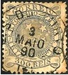
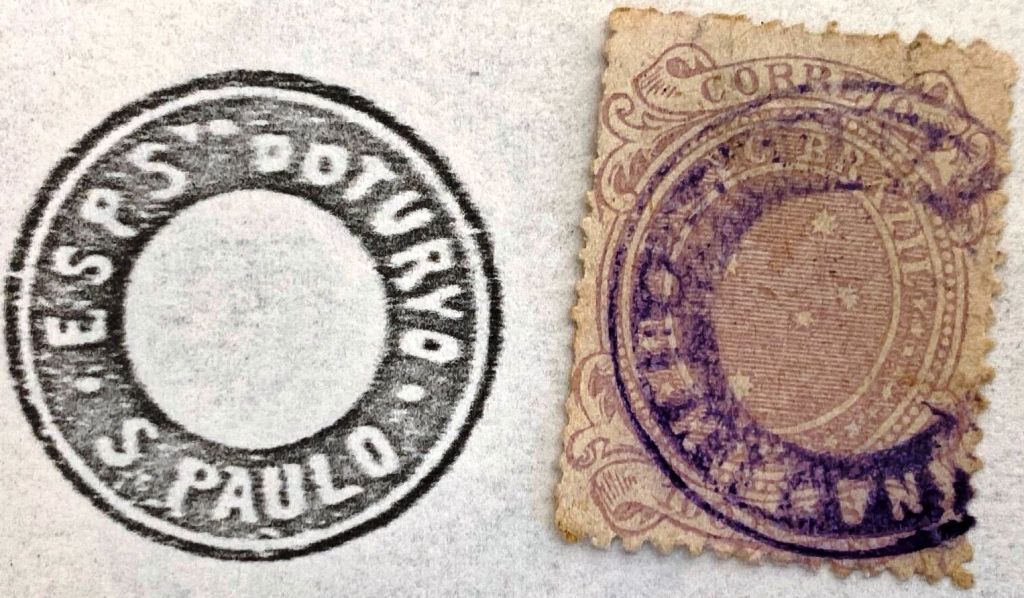
The Freguesia do Espírito Santo do Turvo, founded in March 1878, belonged to the Vila de Lençóis and was located on the south bank of the Turvo, 320 kilometres west of the provincial capital of São Paulo. In March 1885, the village was elevated to a Vila and in December 1906 to a town. In May 1934, however, it was downgraded to a distrito in the Município de Santa Cruz do Rio Pardo and renamed Rio Turvo in November 1938. It was not until January 1990 that it regained the status of a município, now with the old place name Espirito Santo do Turvo.
R. Koester writes in Carimbologia XVIII that there had been a post office there since October 1881. This is confirmed by the press in Rio:
Gazeta de Noticias/RJ, 09/10/1881
Two postmarks were found for the 19th century, the double circle ESP-0495a (ill. by Mario Celso Orsi Jr.) and the archaic-looking ESP-0495b (ill. by Roberto Assef Jr.), which also exists in dark violet:
ESP-0495a (MO) 1885-1890ESP-0495b (RA) 1890ffJ. M. Ribeiro Lisboa: Provincia de São PAulo, 1884
Andere Namen: Rio Turvo
Die im März 1878 gegründete Freguesia do Espírito Santo do Turvo gehörte zur Vila de Lençóis und lag am Südufer des Turvo, 320 km westlich der Provinzhauptstadt São Paulo. Im März 1885 wurde der Ort zur Vila und im Dezember 1906 zur Stadt erhoben. Im Mai 1934 wurde es jedoch zum Distrito im Município de Santa Cruz do Rio Pardo herabgestuft und im November 1938 in Rio Turvo umbenannt. Erst im Januar 1990 wurde der Status eines Município wiedererlangt, nun mit dem alten Ortsnamen Espirito Santo do Turvo.
R. Koester schreibt in Carimbologia XVIII, dass es dort seit Oktober 1881 ein Postamt gab. Dies wird von der Presse in Rio bestätigt:
Gazeta de Noticias/RJ, 09.10.1881
Für das 19. Jahrhundert wurden zwei Poststempel gefunden, der Doppelkreis ESP-0495a (Abb. Mario Celso Orsi Jr.) und der archaisch anmutende ESP-0495b (Abb. Roberto Assef Jr.), den es auch in dunkelviolett gibt:
J. M. Ribeiro Lisboa: Provincia de São Paulo, 1884
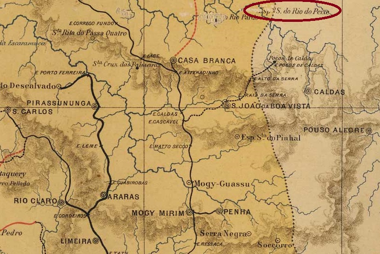
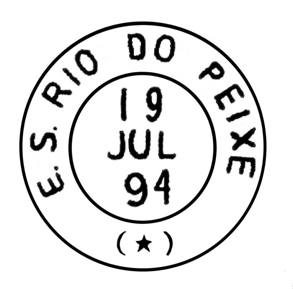
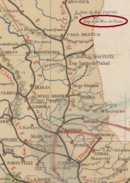
Other names: N. Sra. da Natividade do Rio do Peixe, Sapecado, Divinolândia (1953)
The Divino Espírito Santo chapel, built in January 1858, belonged to the Vila de Caconde and was located on the south bank of the Rio de Peixe (a tributary of the Pardo) near the provincial border with Minas Gerais, 260 kilometres north of the capital São Paulo. In March 1865, it was elevated to a freguesia, which from August 1898 belonged to the Município de S. José do Rio Pardo. Two name changes followed: in November 1938 as Distrito de Sapecado and in December 1953 as Município de Divinolândia.
R. Koester writes in Carimbologia XVIII that there had been a post office there since 1880, which is confirmed by the regional press:
Jornal da Tarde, 24/07/1880
The imperial postmark is the French type ESP-0490a (fig. Claudio Coelho), which was found with dates up to 1925 (!):
ESP-0490a (CC) 1885-1925Provincia de São Paulo, 1886
Andere Namen: N. Sra. da Natividade do Rio do Peixe, Sapecado, Divinolândia (1953)
Die im Januar 1858 errichtete Kapelle Divino Espírito Santo gehörte zur Vila de Caconde und lag am Südufer des Rio de Peixe (einem Nebenfluss des Pardo) nahe der Provinzgrenze zu Minas Gerais, 260 km nördlich der Hauptstadt São Paulo. Im März 1865 wurde es zur Freguesia erhoben, die ab August 1898 zum Município de S. José do Rio Pardo gehörte. Zwei Namensänderungen folgten: Im November 1938 als Distrito de Sapecado und im Dezember 1953 als Município de Divinolândia.
R. Koester schreibt in Carimbologia XVIII, dass es dort seit 1880 ein Postamt gab, was von der regionalen Presse bestätigt wird:
Jornal da Tarde, 24.07.1880
Der kaiserliche Poststempel ist der französische Typ ESP-0490a (Abb. Claudio Coelho), der mit Daten bis 1925 (!) gefunden wurde:
Villiers de l’Ile Adam: Carta (…) da Provincia de São Paulo, 1847
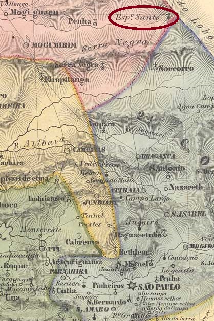
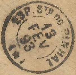
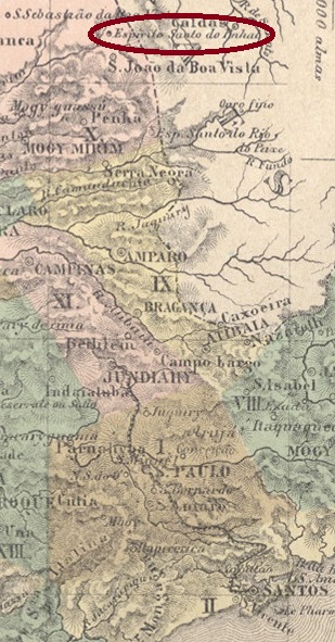
Other names: Pinhal
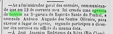
The Freguesia do Espirito Santo do Pinhal was founded in March 1860 and belonged to the Vila de Mogi-Mirim, 190 kilometres north of the provincial capital of São Paulo, close to the border with Minas Gerais. In April 1877 it became a Vila and in March 1883 a city. In November 1938, the município was renamed Pinhal, but in December 1974 the old place name returned.
Nova Monteiro writes in Administrações e Agencias Postaes do Brasil Imperio (Brasil Filatelico/RJ, 1934-5; reprint SPP 1994-1999) that there had been a post office there since December 1867. This is confirmed by the regional press:
Correio Paulistano, 24/12/1867
The only imperial postmark to date is probably not the oldest. The French type ESP-0485b (fig. José L. Fevereiro) only has dates from 1886 onwards:
ESP-0485b (JLF) 1886-1894Atlas do Imperio do Brasil, 1868
Die Freguesia do Espirito Santo do Pinhal wurde im März 1860 gegründet und gehörte zur Vila de Mogi-Mirim, 190 km nördlich der Provinzhauptstadt São Paulo, nahe der Grenze zu Minas Gerais. Im April 1877 wurde sie zur Vila und im März 1883 zur Stadt erhoben. Im November 1938 wurde das Município in Pinhal umbenannt, aber im Dezember 1974 kehrte der alte Ortsname zurück.
Nova Monteiro schreibt in Administrações e Agencias Postaes do Brasil Imperio (Brasil Filatelico/RJ, 1934-5; Nachdruck SPP 1994-1999), dass es dort seit Dezember 1867 ein Postamt gab. Dies wird von der regionalen Presse bestätigt:
Correio Paulistano, 24.12.1867
Der bisher einzige kaiserliche Poststempel ist wahrscheinlich nicht der älteste. Der französische Typ ESP-0485b (Abb. José L. Fevereiro) hat erst Daten ab 1886:
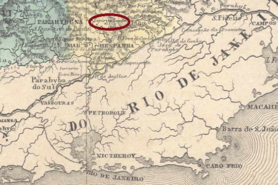
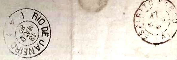
Other names: Espirito Santo do Guarará, Guarará (1891)
From 1839, Divino Espirito Santo was a distrito of the Vila de Barbacena, which lay 260 kilometres south of the provincial capital of Ouro Preto. In January 1868 it became a freguesia of the Vila de Mar d’Hespanha and in December 1890 an independent Vila. Since January 1891 it has been called Municipio Guarará. The name from the Tupi-Guarani language is said to refer to an indigenous drum.
Both Paula Sobrinho (História Postal de Minas Gerais, Belo Horizonte, 1997) and R. Koester (Carimbologia XVIII) write that there has been a post office there since April 1861. However, its creation was already reported as to February of that year by the Rio press:
Correio Mercantil/RJ, 15/03/1861
The oldest postmark is EMG-1145a (fig. C. Papazoglou and José A. Junges), which is often mistakenly assumed to be from the province of Espirito Santo:
EMG-1145a (CP_JJ) 1861ff-1871ff
Its successor is EMG-1145b (image from the Internet):
EMG-1145b (EB) 1877-1885
This postmark could also not be assigned for a very long time. Only thanks to a letter from the Fuad Ferreira Filho collection do we know that it comes from Espirito Santo do Mar d’Hespanha. The letter was written in 1882 in the neighbouring parish of S. Sebastião do Córrego do Meio and took one day to travel from Espirito Santo to Rio de Janeiro, as its postmarks tell us:
Letter Córrego do Meio – Rio de Janeiro, May 1882 (collect. Fuad Ferreira Fo.)
The last imperial postmark is EMG-1145c (Klerman Lopes collection):
EMG-1145c (KL) 1880ff-1893Provincia de Minas Geraes, 1873
Andere Namen: Espirito Santo do Guarará, Guarará (1891)
Seit 1839 war Divino Espirito Santo ein Distrito der Vila de Barbacena, 260 km südlich der Provinzhauptstadt Ouro Preto. Im Januar 1868 wurde es eine Freguesia der Vila de Mar d’Hespanha und im Dezember 1890 eine eigenständige Vila. Seit Januar 1891 heißt das Municipio Guarará. Der Name stammt aus der Tupi-Guarani-Sprache und soll eine indigene Trommel bezeichnen.
Sowohl Paula Sobrinho (História Postal de Minas Gerais, Belo Horizonte, 1997) als auch R. Koester (Carimbologia XVIII) schreiben, dass es dort seit April 1861 ein Postamt gab. Die Gründung wurde jedoch bereits zum Februar desselben Jahres in der Presse von Rio bekannt gegeben:
Correio Mercantil/RJ, 15.03.1861
Der älteste Poststempel ist EMG-1145a (Abb. C. Papazoglou und José A. Junges), der oft fälschlicherweise für einen Stempel aus der Provinz Espirito Santo gehalten wird:
EMG-1145a (CP_JJ) 1861ff-1871ff
Sein Nachfolger ist EMG-1145b (Bild aus dem Internet):
EMG-1145b (EB) 1877-1885
Auch dieser Stempel konnte lange Zeit nicht zugeordnet werden. Erst durch einen Brief aus der Sammlung Fuad Ferreira Filho wissen wir, dass er aus Espirito Santo do Mar d’Hespanha stammt. Der Brief wurde 1882 in der Nachbargemeinde S. Sebastião do Córrego do Meio geschrieben und brauchte einen Tag von Espirito Santo nach Rio de Janeiro, wie die Poststempel belegen:
Aus dem Brief Córrego do Meio – Rio de Janeiro, Mai 1882 (Samml. Fuad Ferreira Fo.)
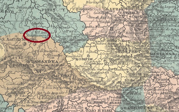
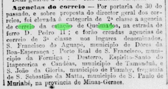
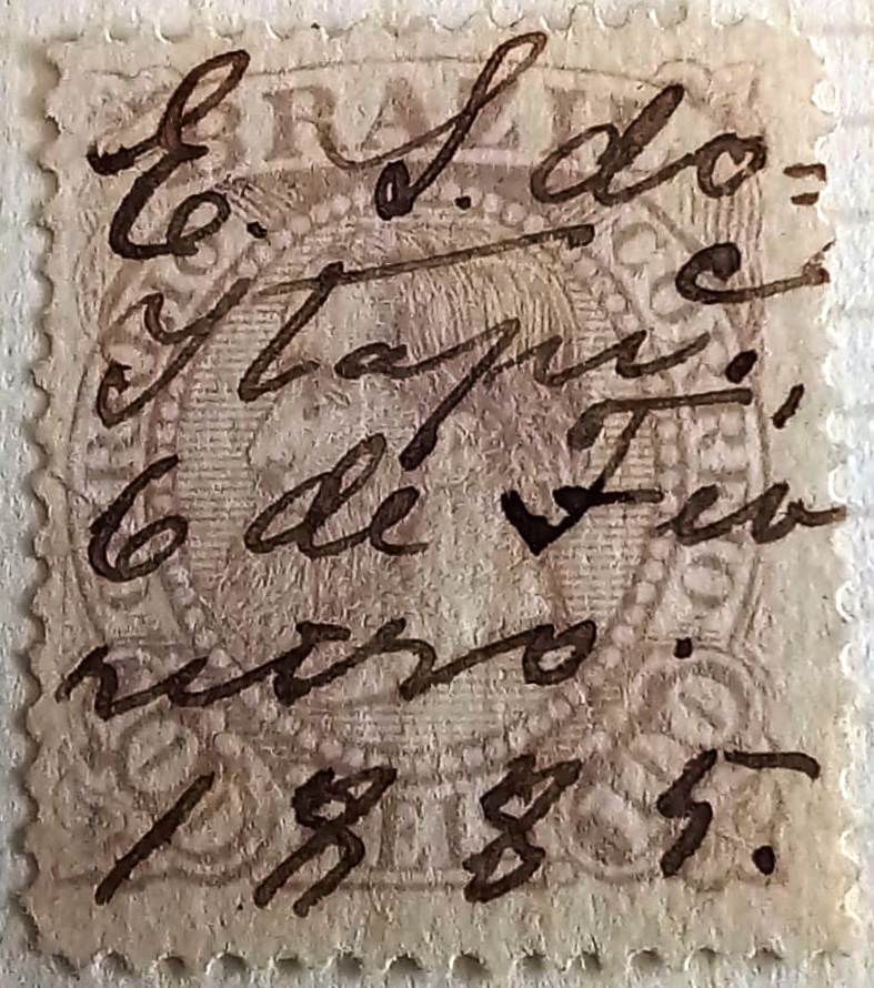
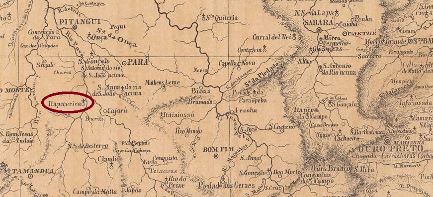
The Distrito do Divino Espírito Santo was founded in April 1839 and is located on the west bank of the Itapecerica River, 200 kilometres west of the provincial capital of Ouro Preto. In August 1911, it was elevated to the status of a Vila under the name Henrique Galvão. The name was intended to commemorate an engineer from the railway company, which had a station there, but the new município was renamed Divinópolis in September 1912, and Divinópolis has been a town since September 1915.
Both Paula Sobrinho (História Postal de Minas Gerais, Belo Horizonte, 1997) and R. Koester (Carimbologia XVIII) state that there has been a post office there since November 1881. This is confirmed by the press in Rio:
Jornal do Commercio/RJ, 02/12/1881
The philatelist Fuad Ferreira Filho has a handwritten cancellation from 1885:
1885 (FF)
The cancel EMG-1140a (fig. Felipe Piccinini) appeared at about the same time:
EMG-1140a (FP) 1885-1893Provincia de Minas Geraes, 1873
Andere Namen: Henrique Galvão, Divinópolis (1912)
Der Distrito do Divino Espírito Santo wurde im April 1839 gegründet und lag am Westufer des Flusses Itapecerica, 200 km westlich der Provinzhauptstadt Ouro Preto. Im August 1911 erfolgte die Erhebung zur Vila unter dem Namen Henrique Galvão. Der Name sollte an einen Ingenieur der Eisenbahngesellschaft erinnern, die dort einen Bahnhof unterhielt, doch schon im September 1912 wurde das neue Município in Divinópolis umbenannt; seit September 1915 ist Divinópolis eine Stadt.
Sowohl Paula Sobrinho (História Postal de Minas Gerais, Belo Horizonte, 1997) als auch R. Koester (Carimbologia XVIII) schreiben, dass es dort seit November 1881 ein Postamt gab. Dies wird von der Presse in Rio bestätigt:
Jornal do Commercio/RJ, 02.12.1881
Der Philatelist Fuad Ferreira Filho hat eine handschriftliche Entwertung von 1885:
1885 (FF)
Etwa zur gleichen Zeit erschien der Stempel EMG-1140a (Abb. Felipe Piccinini):
J. M. Ribeiro Lisboa: Provincia de São Paulo, 1884
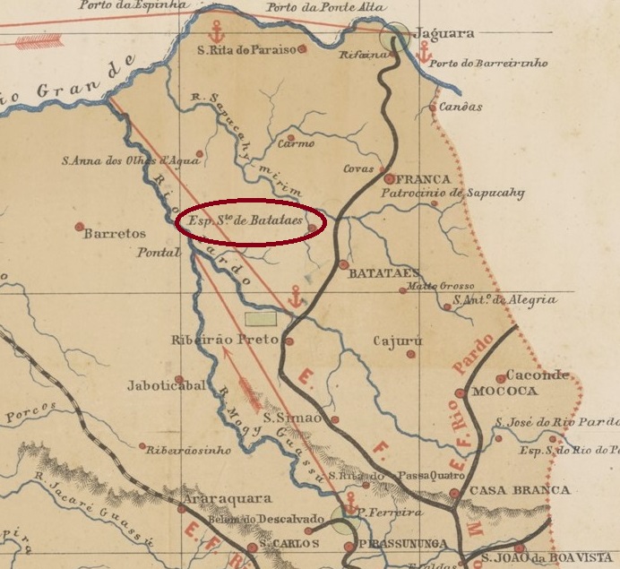
Other names: Nuporanga (1896)
The Freguesia do Divino Espirito Santo was founded in April 1873 370 kilometres north of the provincial capital of São Paulo and belonged to the Vila de Batataes. In March 1885 it was elevated to a Vila and renamed Nuporanga in December 1896. Nuporanga was downgraded to a Distrito in the Município de Orlândia in November 1909, but regained its political autonomy as a Município in December 1926. The name comes from the Tupi-Guarani language and means “beautiful meadow”.
R. Koester writes in Carimbologia XVIII that there had been a post office there since July 1884. This is confirmed by the press in Rio:
Gazeta de Noticias/RJ 17/07/1884
The imperial postmark is ESP-0480a (fig. R. Koester, op. cit.):
ESP-0480a (RK) 1885-1893Provincia de São Paulo, 1886
Andere Namen: Nuporanga (1896)
Die Freguesia do Divino Espirito Santo wurde im April 1873 370 km nördlich der Provinzhauptstadt São Paulo gegründet und gehörte zur Vila de Batataes. Im März 1885 wurde es zur Vila erhoben und im Dezember 1896 in Nuporanga umbenannt. Nuporanga wurde im November 1909 zu einem Distrito im Município de Orlândia herabgestuft, erlangte aber im Dezember 1926 seine politische Autonomie als Município zurück. Der Name stammt aus der Sprache der Tupi-Guarani und bedeutet “schöne Wiese”.
R. Koester schreibt in Carimbologia XVIII, dass es dort seit Juli 1884 ein Postamt gab. Dies wird von der Presse in Rio bestätigt:
Gazeta de Noticias/RJ 17.07.1884
Der kaiserliche Poststempel ist ESP-0480a (Abb. R. Koester, op. cit.):