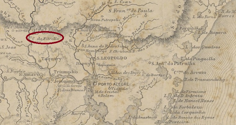
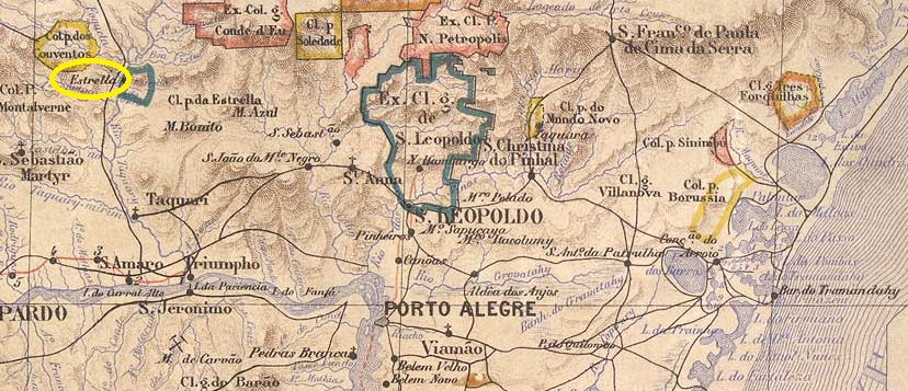
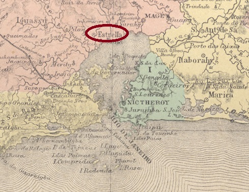
The Freguesia de Santo Antonio da Estrella, founded in April 1873, belonged to the Vila de Taquary and was located on the east bank of the river of the same name, 110 kilometres northwest of the provincial capital of Porto Alegre. In May 1876, it was elevated to the status of a Vila.
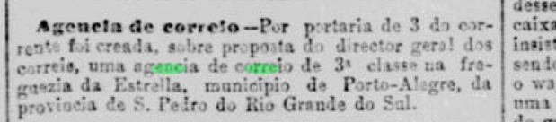
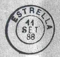
As the Rio press reported, there had been a post office there since February 1882:
Jornal do Commercio/RJ, 05/02/1882
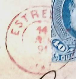
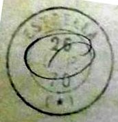
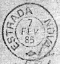
The imperial postmark is the French type ERS-0170a (coll. Fuad Ferreira Fo.), which also exists in red:
ERS-0170a (FF) 1891
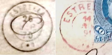
As there was previously also a french-type postmark from Estrella in the province of Rio de Janeiro, here is a comparison of both cancellations (Estrella/RS on the right):
ERJ-0530a x ERS-0170aEstado do Rio Grande do Sul, 1891
Die im April 1873 gegründete Freguesia de Santo Antonio da Estrella gehörte zur Vila de Taquary und lag am Ostufer des gleichnamigen Flusses, 110 km nordwestlich der Provinzhauptstadt Posto Alegre. Im Mai 1876 wurde es zur Vila erhoben.
Wie die Presse von Rio berichtete, gab es dort seit Februar 1882 ein Postamt:
Jornal do Commercio/RJ, 05.02.1882
Der kaiserliche Poststempel ist der französische Typ ERS-0170a (Samml. Fuad Ferreira Fo.), den es auch in rot gibt:
ERS-0170a (FF) 1891
Da es zuvor auch einen „französischen“ Stempel aus Estrella in der Provinz Rio de Janeiro gab, hier ein Vergleichsbild beider Poststempel (rechts Estrella/RS):
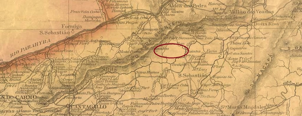
Villiers de l’Ile Adam: Carta (…) da Provincia do Rio de Janeiro, 1850
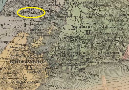
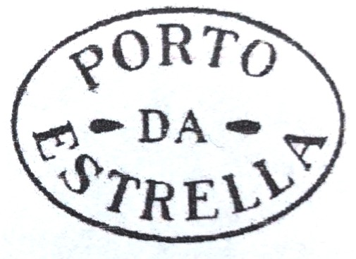
Other names: Porto da Estrella
Founded in January 1755, Arraial do Porto da Estrela belonged to the Vila de N. Sra. da Piedade do Inhomirim and was located on the west bank of the Rio da Estrela, 50 kilometres north of the capital Rio de Janeiro. At the time, the harbour was conveniently located near Guanabara Bay on the main road to the gold and mining province of Minas Gerais (Estrada Real). The settlement grew very quickly and became an independent vila in May 1846. A period of decline followed, caused by epidemics, mismanagement and, above all, the construction of railway lines away from the old trade route. A little further north, the Estrella railway station (later: Joaquim Távora, today: Imbarié) was opened in 1888 by the E.F. Principe do Grão-Pará railway company, which occasionally leads to confusion with the old vila.
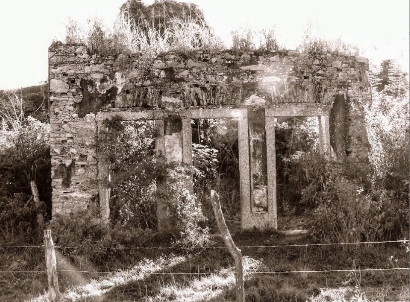
The once proud and prosperous locality, which became a neighbourhood in the district of Inhomirim in the Município de Magé in May 1892, was never able to recover from its social and economic decline. Today, only a few ruins bear witness to its former prosperity:
The so-called Three Door House (Casa das Três Portas, photo: Mario Pinheiro)
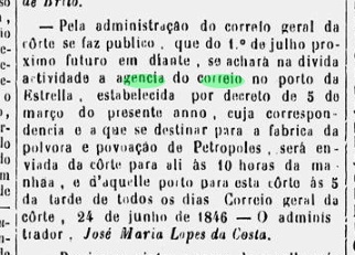
As the regional press reported, there had been a post office there since March 1846:
Diario do Rio de Janeiro, 26/06/1846
This was closed in January 1897, as P. Novaes (agenciaspostais.com.br) writes. The oldest cancel is PRJ-2600a, shown with no. 1414 by P. Ayres in Catálogo de Carimbos Brasil-Império (S. Paulo, 1937, 1942):
PRJ-2600a (P.A. 1414) 1846-1850ff
This was followed by the rare French type ERJ-0530a (collect. Fuad Ferreira Fo.):
ERJ-0530a (FF) 1870
As there was also a French type postmark from Estrella in the southern Brazilian province of São Pedro do Rio Grande shortly afterwards, here is a comparison of the two postmarks (Estrella/RS on the right):
ERJ-0530a x ERS-0170a
Porto da Estrella has two more postmarks from the imperial period, which are illustrated in R. Koester’s Carimbologia XVIII: the double circle ERJ-0530b and the cachet ERJ-0530c:
ERJ-0530b (RK) 1888ERJ-0530c (RK)Atlas do Imperio do Brasil, 1868
Andere Namen: Porto da Estrella
Der im Januar 1755 gegründete Arraial do Porto da Estrela gehörte zur Vila de N. Sra. da Piedade do Inhomirim und lag am Westufer des Rio da Estrela, 50 km nördlich der Hauptstadt Rio de Janeiro. Die Hafenanlage lag damals verkehrsgünstig nahe der Guanabara-Bucht an der Hauptstraße in die Gold- und Bergbauprovinz Minas Gerais (Estrada Real). Die Siedlung wuchs sehr schnell und wurde im Mai 1846 eine eigenständige Vila. Es folgte eine Zeit des Niedergangs, verursacht durch Epidemien, Misswirtschaft und vor allem durch den Bau von Eisenbahnlinien abseits der alten Handelsroute. Etwas weiter nördlich wurde 1888 der Bahnhof Estrella (später: Joaquim Távora, heute: Imbarié) von der Eisenbahngesellschaft E.F. Principe do Grão-Pará eröffnet, was gelegentlich zu Verwechslungen mit der alten Vila führt.
Die einst stolze und wohlhabende Vila, die im Mai 1892 zum Ortsteil im Bezirk Inhomirim des Município de Magé wurde, konnte sich vom sozialen und wirtschaftlichen Niedergang nicht mehr erholen. Heute zeugen nur noch wenige Ruinen vom damaligen Wohlstand:
Das so genannte Drei-Türen-Haus (Casa das Três Portas, Foto: Mario Pinheiro)
Wie die regionale Presse berichtete, gab es dort seit März 1846 ein Postamt:
Diario do Rio de Janeiro, 26.06.1846
Dieses wurde im Januar 1897 geschlossen, wie P. Novaes (agenciaspostais.com.br) schreibt. Der älteste Stempel ist PRJ-2600a, gezeigt mit Nr. 1414 von P. Ayres in Catálogo de Carimbos Brasil-Império (S. Paulo, 1937, 1942):
PRJ-2600a (P.A. 1414) 1846-1850ff
Es folgte der seltene französische Typ ERJ-0530a (Samml. Fuad Ferreira Fo.):
ERJ-0530a (FF) 1870
Da es kurz darauf auch einen „französischen“ Stempel aus Estrella in der südbrasilianischen Provinz São Pedro do Rio Grande gab, hier ein Vergleichsbild beider Poststempel (rechts Estrella/RS):
ERJ-0530a x ERS-0170a
Aus Porto da Estrella stammen noch zwei weitere Poststempel aus der Kaiserzeit, die in R. Koesters Carimbologia XVIII abgebildet sind: der Doppelkreis ERJ-0530b und der Siegelstempel ERJ-0530c:
Other names: Arraial do Tatu, Itapexirica, Conceição da Estrada Nova
See also Arraial da Conceição (ARJ-0065)
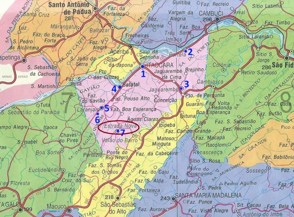
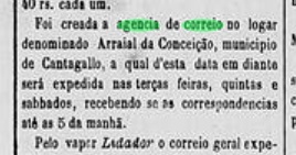
This settlement was originally called Arraial do Tatu or Itapexirica and was located near Cantagallo, 240 km northeast of the capital Rio de Janeiro. In 1859 it was renamed N. Sa. da Conceição da Estrada Nova, and in September 1890 it became a district, changing to the newly created Município of Itaocara the following month. Finally, in November 1924, the district was given the simplified name of Estrada Nova.
The local post office was established in December 1873, as reported by the regional press:
A Reforma, 06.12.1873
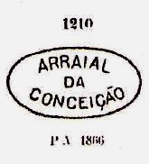
The first postmark is ARJ-0065a, which also exists in brown, blue, green and dark purple. It was in use until about 1879 and is already known through Paulo Ayres (Catálogo de Carimbos Brasil-Império, S. Paulo, 1937, 1942) under No. 1210:
ARJ-0065a (P.A. 1210, MPT 351)
Further postmarks (from around 1881) bear the place name Estrada Nova and have already been presented by R. Koester in Carimbologia XIII. Here we have the postmark CRJ-0355a:
CRJ-0355a (RK)
And towards the end of the imperial period came the double circle ERJ-0525a:
ERJ-0525a (RK) 1881-1890Colton: Provincia do Rio de Janeiro, 1866
Andere Namen: Arraial do Tatu, Itapexirica, Conceição da Estrada Nova
Siehe auch Arraial da Conceição (ARJ-0065)
Diese Siedlung hieß ursprünglich Arraial do Tatu bzw. Itapexirica und lag bei Cantagallo, 240 km nordöstlich der Hauptstadt Rio de Janeiro entfernt. 1859 erfolgte eine Umbenennung zu N. Sa. da Conceição da Estrada Nova, und im September 1890 wurde daraus ein Distrikt, der im darauffolgenden Monat zum neu gegründeten Município von Itaocara wechselte. Schließlich erhielt der Distrikt im November 1924 den verinfachten Namen Estrada Nova.
Das örtliche Postamt wurde im Dezember 1873 ins Leben gerufen, wie die Regionalpresse meldete:
A Reforma, 06.12.1873
Der erste Poststempel ist ARJ-0065a, den es auch in braun, blau, grün und dunkelviolett gibt. Er war bis ca. 1879 in Verwendung und ist bereits durch Paulo Ayres (Catálogo de Carimbos Brasil-Império, S. Paulo, 1937, 1942) unter Nr. 1210 bekannt:
ARJ-0065a (P.A. 1210, MPT 351)
Weitere Poststempel (ab ca. 1881) tragen den Ortsnamen Estrada Nova und wurden bereits von R. Koester in Carimbologia XIII vorgestellt. Hier haben wir den Stempel CRJ-0355a:
CRJ-0355a (RK)
Und gegen Ende der Kaiserzeit kam der Doppelkreis ERJ-0525a:
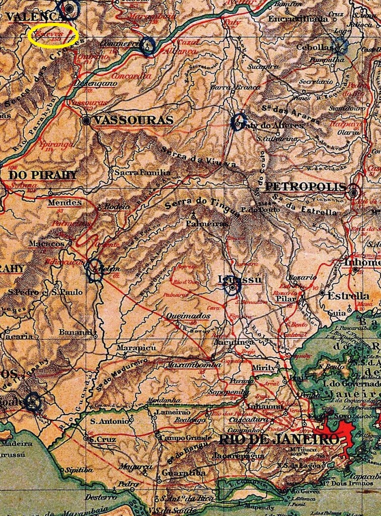
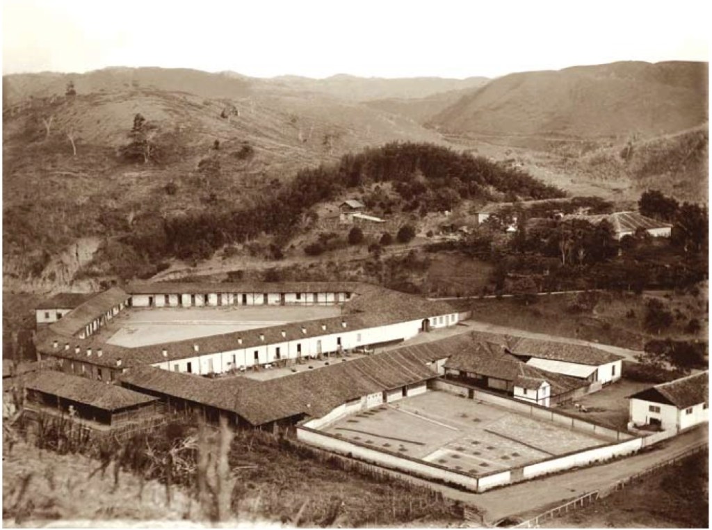
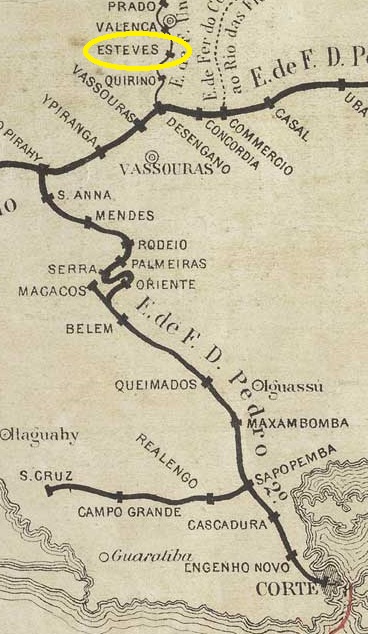
Esteves station was opened in May 1871 by the railway company E.F. União Valenciana (Jacutinga branch) in the Vila de Valença region, 150 km north-west of the capital Rio de Janeiro. The line belonged to E.F. Central do Brasil (estacoesferroviarias.com.br) from 1910 until its closure in 1970.
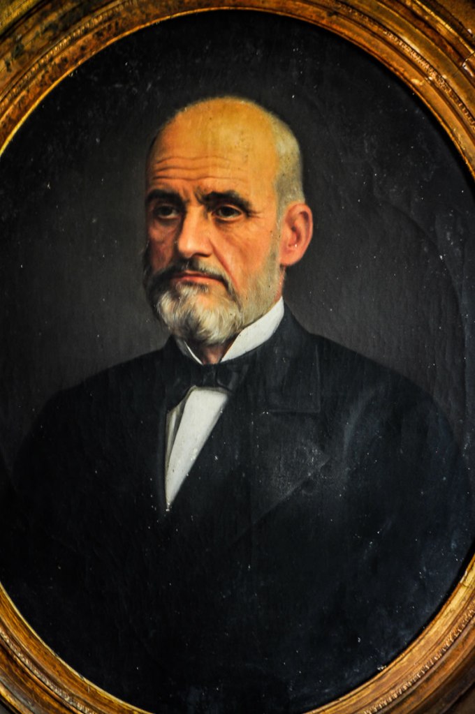
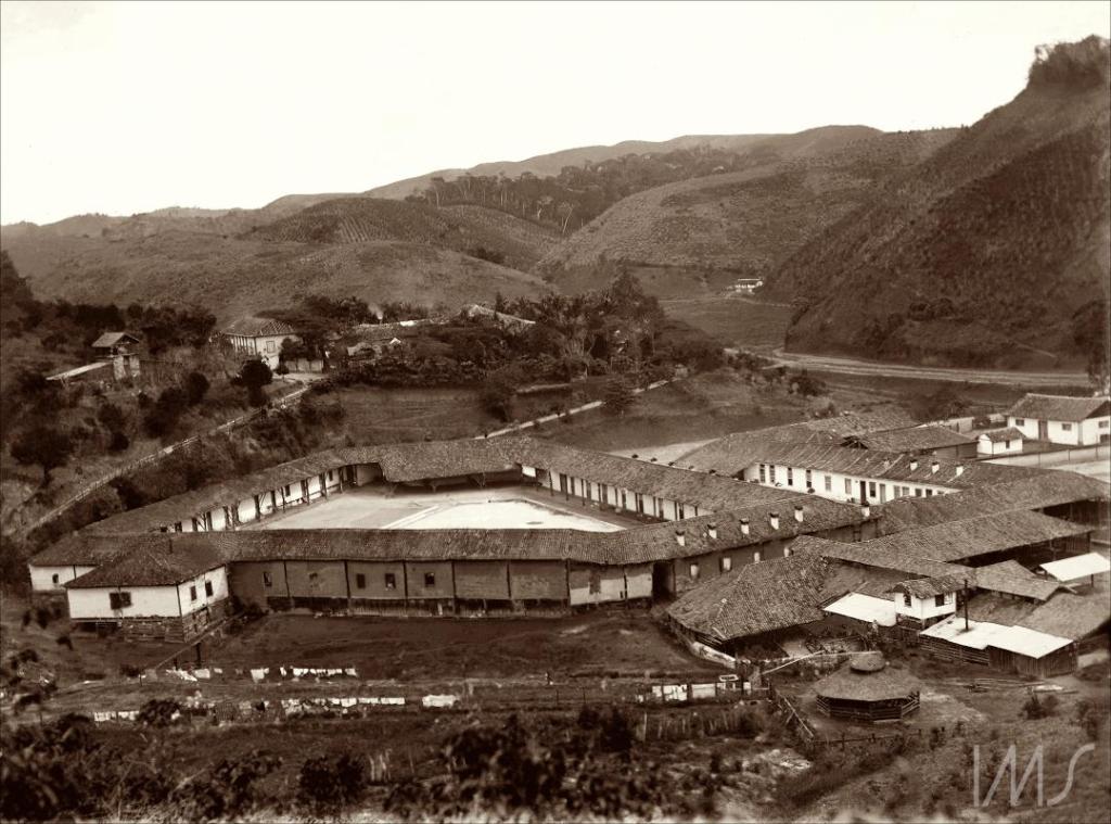
The station was named after the Portuguese coffee baron Manuel Antonio Esteves (1813-1879), whose Fazenda Santo Antonio do Paiol now belongs to a Catholic order of priests. Manuel Esteves not only had his railway station built, but also financed the construction of the railway line.
Manuel Antonio Esteves (unknown artist)Fazenda Santo Antonio do Paiol, around 1885 (Photo: Marc Ferrez, Instituto Moreira Salles)
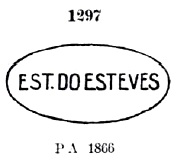
As Paulo Novaes writes on agenciaspostais.com.br, there was a post office at the railway station from October 1871. The oldest postmark is ERJ-0520a, also known from P. Ayres Catálogo de Carimbos Brasil-Império (S. Paulo, 1937, 1942) under no. 1297:
ERJ-0520a (P.A. 1297) 1871-1878
This was followed by ERJ-0520b (Abb. Márcio Duarte):
ERJ-0520b (MD) 1881-1894
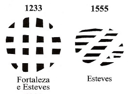
In Mute Cancellations of the Brazil Empire / Carimbos Mudos do Brasil Império (Brazil Philatelic Association, Rio de Janeiro, 2000), James Dingler and Klerman W. Lopes have also presented two mute cancellations of the station post office under the numbers 1233 and 1555:
BPA1233 (1881) – 1555Estações (…) do Rio de Janeiro, São Paulo e Minas Geraes, 1880
Der Bahnhof Esteves wurde im Mai 1871 von der Eisenbahngesellschaft E.F. União Valenciana (Abzweig Jacutinga) eröffnet und liegt in der Region Vila de Valença, 150 km nordwestlich der Hauptstadt Rio de Janeiro. Die Strecke gehörte von 1910 bis zu ihrer Stilllegung 1970 der E.F. Central do Brasil (estacoesferroviarias.com.br).
Benannt wurde der Bahnhof nach dem portugiesischen Kaffeebaron Manuel Antonio Esteves (1813-1879), dessen Fazenda Santo Antonio do Paiol heute einem katholischen Priesterorden gehört. Manuel Esteves ließ nicht nur seinen Bahnhof bauen, sondern finanzierte auch den Bau der Eisenbahnstrecke.
Manuel Antonio Esteves (unbekannter Künstler)Fazenda Santo Antonio do Paiol, um 1885 (Foto: Marc Ferrez, Instituto Moreira Salles)
Wie Paulo Novaes auf agenciaspostais.com.br schreibt, gab es ab Oktober 1871 ein Postamt am Bahnhof. Der älteste Poststempel ist ERJ-0520a, auch bekannt durch P. Ayres Catálogo de Carimbos Brasil-Império (S. Paulo, 1937, 1942) mit Nr. 1297:
ERJ-0520a (P.A. 1297) 1871-1878
Es folgte ERJ-0520b (Abb. Márcio Duarte):
ERJ-0520b (MD) 1881-1894
James Dingler und Klerman W. Lopes haben in Mute Cancellations of the Brazil Empire / Carimbos Mudos do Brasil Império (Brazil Philatelic Association, Rio de Janeiro, 2000) unter den Nummern 1233 und 1555 auch zwei stumme Abstempelungen des Bahnhofspostamtes vorgestellt:
Other names: Estação do Campo de Sant’Anna/da Aclamação, Estação da Corte, Dom Pedro II (1925)
The main station of Brazil’s most important railway line in the 19th century was inaugurated in March 1858 by the E.F. D. Pedro II and was located on the Campo de Aclamação field, relatively close to Rio de Janeiro’s city centre. After the republican military coup in 1889, the railway line was renamed E.F. Central do Brasil. From 1925, the station was called Estação D. Pedro II, but the population simply continued to call it Estação Central. The line became the property of Rede Ferroviária Federal S.A. in 1975 and has been operated by the Supervia consortium since 1997.
Ca. 1870 (Biblioteca Nacional)In 2003 (Photo NN, on estacoesferroviarias.com.br)
As Paulo Novaes reports in agenciaspostais.com.br, there had been a post office at the station since August 1869, which operated under the name Estação Central from November 1889. To avoid duplicate code numbers for the same postmarks, the numbers used here are the same from the Carimbologia book on provincial administrations (ArGe-Brasilien, Lohmar, 2023).
The oldest cancel is RJA-0020 (fig. R. Koester, in Carimbologia XVIII):
RJA-0020 (RK) 1869ff
The Correio Urbano postmark RJU-0014 (P.A. 1029), known from Paulo Ayres’ Catálogo de Carimbos Brasil-Império (S. Paulo, 1937, 1942) with no. 1029, was also used at about the same time.
RJU-0014 (P.A. 1029) 1869ff-1870ff
This was followed by RJA-0021 (fig. P. Novaes, op. cit.):
RJA-0021 (PN) 1876ff-1883ff
This was followed by the previously unknown EMN-0025a (fig. Koester-Novaes):
EMN-0025a (RK-PN) 1885
Towards the end of the Empire, two more postmarks appeared as double circles: RJA-0022 (ill. José A. Junges) and RJA-0023 (ill. Fuad Ferreira Fo.):
RJA-0022 (JJ) 1886-1889RJA-0023 (FF) 1888-1889Biblioteca Nacional
Andere Namen: Estação do Campo de Sant’Anna/da Aclamação, Estação da Corte, Dom Pedro II (1925)
Der Hauptbahnhof der wichtigsten Eisenbahnlinie Brasiliens im 19. Jahrhundert wurde im März 1858 von der E.F. D. Pedro II. eingeweiht und lag auf dem Feld Campo de Aclamação, relativ nahe am Stadtzentrum von Rio de Janeiro. Nach dem republikanischen Militärputsch 1889 wurde die Bahnlinie in E.F. Central do Brasil umbenannt. Ab 1925 hieß der Bahnhof Estação D. Pedro II, aber die Bevölkerung nannte ihn einfach weiterhin Estação Central. Die Strecke ging 1975 in den Besitz der Rede Ferroviária Federal S.A. über und wird seit 1997 vom Konsortium Supervia betrieben.
Ca. 1870 (Biblioteca Nacional)2003 (Foto NN, auf estacoesferroviarias.com.br)
Wie Paulo Novaes in agenciaspostais.com.br berichtet, gab es seit August 1869 ein Postamt am Bahnhof, das ab November 1889 unter dem Namen Estação Central firmierte. Um doppelte Codenummern bei den Poststempeln zu vermeiden, werden hier die Nummern übernommen, wie sie im Carimbologia-Buch der Postverwaltungen in den Provinzen verwendet wurden (ArGe-Brasilien, Lohmar, 2023).
Der älteste Stempel ist RJA-0020 (Abb. R. Koester, in Carimbologia XVIII):
RJA-0020 (RK) 1869ff
Etwa zur gleichen Zeit wurde auch der Poststempel des Correio UrbanoRJU-0014 (P.A. 1029) verwendet, bekannt durch Paulo Ayres‘ Catálogo de Carimbos Brasil-Império (S. Paulo, 1937, 1942) mit Nr. 1029.
RJU-0014 (P.A. 1029) 1869ff-1870ff
Es folgte RJA-0021 (Abb. P. Novaes, op. cit.):
RJA-0021 (PN) 1876ff-1883ff
Es folgte der bisher unbekannte EMN-0025a (Abb. Koester-Novaes):
EMN-0025a (RK-PN) 1885
Gegen Ende des Kaiserreichs erschienen noch zwei weitere Poststempel als Doppelkreise: RJA-0022 (Abb. José A. Junges) und RJA-0023 (Abb. Fuad Ferreira Fo.):
Municipio de Campos, 1922 (estacoesferroviarias.com.br)
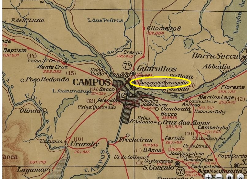
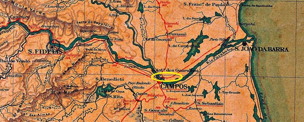
Other names: Campos do Carangola
The main station of the E.F. Carangola was inaugurated around September 1877 and was located on the north bank of the Paraíba do Sul on the outskirts of Campos, 280 km north-east of the capital Rio de Janeiro. The line became the property of the company E.F. Barão de Araruama in 1890, which sold it to the company E.F. Leopoldina in the same year. From 1975 until the line was closed in 1996, it belonged to Rede Ferroviária Federal S.A. (estacoesferroviarias.com.br).
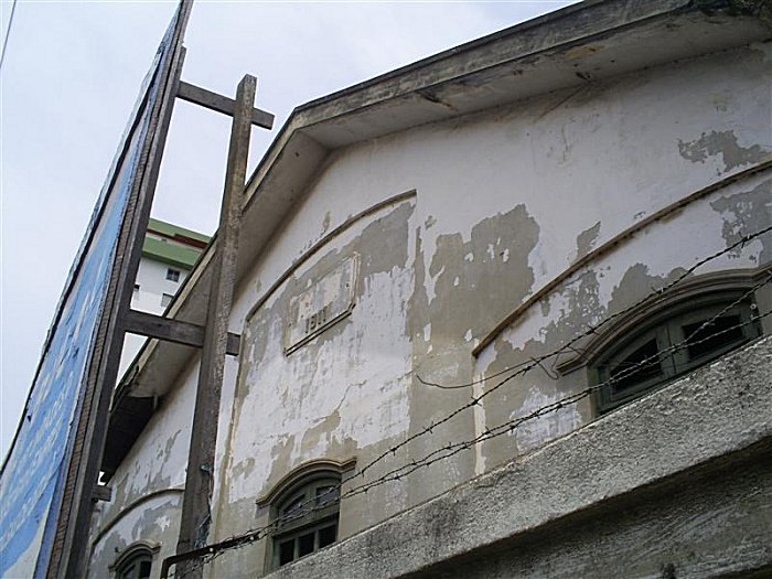
Presumably, after the inauguration of the railway bridge over the Paraíba do Sul in 1907, the main station was converted into a cargo station of the E.F. Leopoldina and the station on the south bank became responsible for passenger traffic. This hypothesis is supported by the year 1911 on the now abandoned cargo station building.
In October 2010 (Photo: Eduardo Moreira, on estacoesferroviarias.com.br)
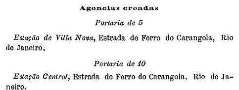
In September 1889, a station post office was opened, as can be seen from the postal bulletin (Boletim Postal) no. 6 of the following month:
Boletim Postal No. 6, October 1889
No imperial postmark from this post office has ever been seen before, so it must be rare.
Almanak Laemmert, 1892
Andere Namen: Campos do Carangola
Der Hauptbahnhof der E.F. Carangola wurde um September 1877 eingeweiht und lag am Nordufer des Paraíba do Sul am Stadtrand von Campos, 280 km nordöstlich der Hauptstadt Rio de Janeiro. Die Strecke ging 1890 in den Besitz der Firma E.F. Barão de Araruama über, die sie im selben Jahr an die Firma E.F. Leopoldina verkaufte. Von 1975 bis zur Stilllegung der Strecke 1996 gehörte sie der Rede Ferroviária Federal S.A. (estacoesferroviarias.com.br).
Vermutlich wurde der Hauptbahnhof nach der Einweihung der Eisenbahnbrücke über den Paraíba do Sul 1907 in einen Güterbahnhof der E.F. Leopoldina umgewandelt und der Bahnhof am Südufer für den Personenverkehr zuständig. Diese Hypothese wird durch die Jahreszahl 1911 auf dem heute verlassenen Güterbahnhofsgebäude gestützt.
Im Oktober 2010 (Foto: Eduardo Moreira, auf estacoesferroviarias.com.br)
Im September 1889 wurde ein Bahnhofspostamt eröffnet, wie aus dem Postbulletin (Boletim Postal) Nr. 6 des Folgemonats hervorgeht:
Boletim Postal Nr. 6, Oktober 1889
Bisher wurde noch kein kaiserlicher Poststempel von diesem Bahnhof gesehen, es muss sich also um einen seltenen Stempel handeln.
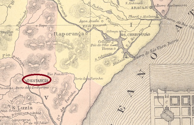
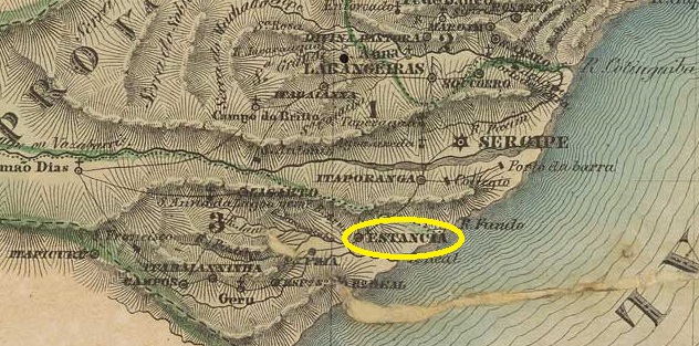
The original settlement called N. Sra. de Guadelupe has been known since April 1757. It belonged to the Vila de Sta. Luzia do Real and was located on the north bank of the Piauí, 80 kilometres southwest of the later provincial capital of Aracaju. In October 1831 it became the Freguesia e Vila Constitucional da Estancia and in May 1848 it was elevated to the status of a town.
Both Nova Monteiro (Administrações e Agencias Postaes do Brasil Imperio, in Brasil Filatelico/RJ, 1934-5; reprint SPP 1994-1999) and R. Koester (Carimbologia XVIII) write that there had been a post office there since December 1844. The directory of imperial post offices (Tabella das Agencias do Correio do Imperio, Rio de Janeiro, 1885) gives here the year 1845, which perhaps indicates that the agency was then set in operation.
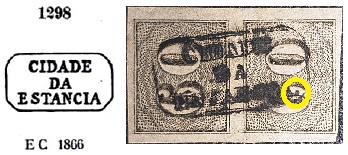
Here we can be relatively certain that the first postmark is missing, as the oldest ESE-0070b to date bears the inscription Cidade (city) and was therefore used in 1848 at the earliest. It bears the no. 1298 in P. Ayres’ Catálogo de Carimbos Brasil-Império (S. Paulo, 1937, 1942), but the dot after ESTANCIA is here missing, as can be seen in the other illustration (image: F. Piccinini):
ESE-0070b (P.A. 1298 /recte FP) 1850ff-1876ff
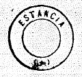
R. Koester (op. cit.) also shows the French type ESE-0070c:
ESE-0070c (MPT 393, RK)
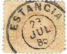
ESE-0070d (image from the Internet) was also used about the same time:
ESE-0070d (EB) 1877-1894Villiers de l’Ile Adam: Carta (…) das Provincias de Pernambuco, Alagoas e Sergipe, 1848
Die ursprüngliche Siedlung N. Sra. de Guadelupe ist seit April 1757 bekannt, sie gehörte zur Vila de Sta. Luzia do Real und lag am Nordufer des Piauí, 80 km südwestlich der späteren Provinzhauptstadt Aracaju. Im Oktober 1831 wurde es zur Freguesia e Vila Constitucional da Estancia und im Mai 1848 zur Stadt erhoben.
Sowohl Nova Monteiro (Administrações e Agencias Postaes do Brasil Imperio, in Brasil Filatelico/RJ, 1934-5; Reprint SPP 1994-1999) als auch R. Koester (Carimbologia XVIII) schreiben, dass es dort seit Dezember 1844 ein Postamt gab. Das Verzeichnis der kaiserlichen Postämter (Tabella das Agencias do Correio do Imperio, Rio de Janeiro, 1885) gibt hier das Jahr 1845 an, was vielleicht auf die Inbetriebnahme der Agentur hinweist.
Hier können wir relativ sicher sein, dass der erste Poststempel fehlt, da der bisher älteste ESE-0070b die Aufschrift Cidade (Stadt) trägt und somit frühestens 1848 verwendet wurde. Er trägt die Nr. 1298 in P. Ayres‘ Catálogo de Carimbos Brasil-Império (S. Paulo, 1937, 1942), aber der Punkt nach ESTANCIA fehlt hier, wie auf der anderen Abbildung zu sehen ist (Foto: F. Piccinini):
ESE-0070b (P.A. 1298 /recte FP) 1850ff-1876ff
R. Koester (op. cit.) zeigt hier auch den französischen Typ ESE-0070c:
ESE-0070c (MPT 393, RK)
Parallel dazu wurde auch ESE-0070d (Bild aus dem Internet) verwendet:
Estações (…) do Rio de Janeiro, São Paulo e Minas Geraes, 1880
Text update on August 16, 2024
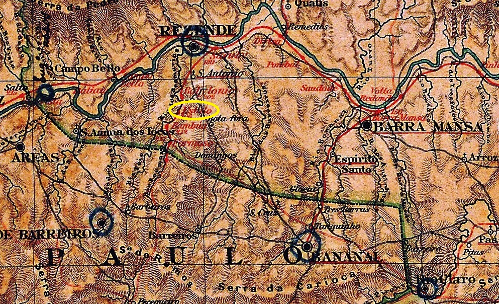
Estallo station was opened in November 1877 by the railway company E.F. de Resende a Areias (later E.F. de Resende a Bocaína) on the east bank of the river Sesmaria in the Município Resende, 180 km west of the capital Rio de Janeiro. The railway line was closed in 1928 and today both the station building and the tracks have disappeared (estacoesferroviarias.com.br).
Early 20th century (Photo: NN, on estacoesferroviarias.com.br)
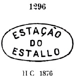
As Paulo Novaes writes on agenciaspostais.com.br, there had been a post office at the station since July 1878. The first postmark is ERJ-0505a, which was given the number 1296 by P. Ayres in the Catálogo de Carimbos Brasil-Império (S. Paulo, 1937, 1942):
ERJ-0505a (P.A. 1296) 1878ff
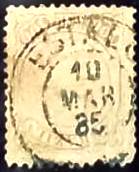
It was followed by the French type ERJ-0505b, of which unfortunately the illustration is missing. ERJ-0505c from the Fuad Ferreira Fo. collection has since appeared:
ERJ-0505c (FF) 1885
Towards the end of the Empire, ERJ-0505d (ill. R. Koester on Carimbologia XVIII) was also used:
ERJ-0505d (RK) 1886-1889
R. Koester (op. cit.) also shows the cancel with the imperial seal ERJ-0505e:
ERJ-0505e (RK)
The following ERJ-0505f (ill. agenciaspostais.com.br) is probably already republican:
ERJ-0505f (PN) 1893Almanak Laemmert, 1892
Textaktualisierung am 16. August 2024
Der Bahnhof Estallo wurde im November 1877 von der Eisenbahngesellschaft E.F. de Resende a Areias (später E.F. de Resende a Bocaína) eröffnet und lag am Ostufer des Flusses Sesmaria im Município Resende, 180 km westlich der Hauptstadt Rio de Janeiro. Die Bahnlinie wurde 1928 stillgelegt, heute sind sowohl das Bahnhofsgebäude als auch die Gleise verschwunden (estacoesferroviarias.com.br).
Anfang des 20. Jahrhunderts (Foto: NN, auf estacoesferroviarias.com.br)
Wie Paulo Novaes auf agenciaspostais.com.br schreibt, gab es ein Postamt am Bahnhof seit Juli 1878. Der erste Poststempel ist ERJ-0505a, der die Nr. 1296 von P. Ayres im Catálogo de Carimbos Brasil-Império (S. Paulo, 1937, 1942) erhielt:
ERJ-0505a (P.A. 1296) 1878ff
Es folgte der französische Typ ERJ-0505b, von dem leider die Abbildung noch fehlt. Aus der Sammlung Fuad Ferreira Fo. erschien inzwischen ERJ-0505c:
ERJ-0505c (FF) 1885
Gegen Ende des Kaiserreichs kam auch ERJ-0505d (Abb. R. Koester auf Carimbologia XVIII):
ERJ-0505d (RK) 1886-1889
R. Koester (op. cit.) zeigt auch den Stempel mit dem kaiserlichen Siegel ERJ-0505e:
ERJ-0505e (RK)
Der folgende ERJ-0505f (Abb. agenciaspostais.com.br) dürfte bereits republikanisch sein:
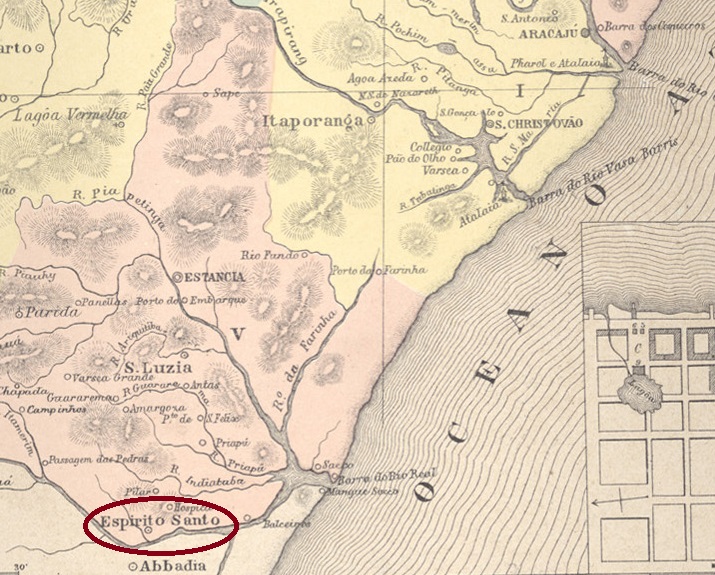
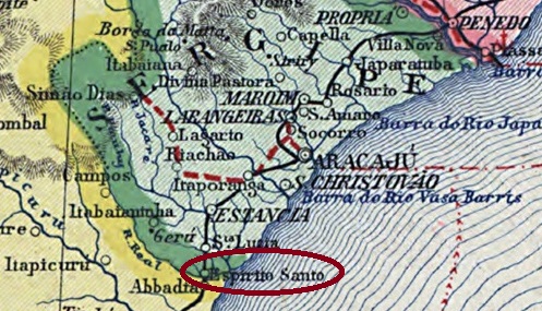
Other names: Espirito Santo do Rio Real, Indiaroba (1943)
The Freguesia do Espirito Santo, founded in March 1841, belonged to the Vila de Estância and was located on the north bank of the Rio Real on the provincial border with Bahia, 100 kilometres south of the later capital Aracaju. Five years later it was elevated to Vila do Espirito Santo do Rio Real and since December 1943 the município has been called Indiaroba. The term comes from the Tupi-Guarani and means seed of the Indaiá palm.
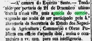
Nova Monteiro writes in Administrações e Agencias Postaes do Brasil Imperio (Brasil Filatelico/RJ, 1934-5; reprint SPP 1994-1999) that there has been a post office there since December 1861. This is confirmed by the regional press:
Correio Sergipense, 06.01.1862
Unfortunately, no imperial postmark has yet been assigned to this place with certainty.
Carta da Republica dos Estados Unidos do Brazil, 1892
Andere Namen: Espirito Santo do Rio Real, Indiaroba (1943)
Die im März 1841 gegründete Freguesia do Espirito Santo gehörte zur Vila de Estância und lag am Nordufer des Rio Real an der Provinzgrenze zu Bahia, 100 km südlich der späteren Hauptstadt Aracaju. Fünf Jahre später erfolgte die Erhebung zur Vila do Espirito Santo do Rio Real und seit Dezember 1943 heißt der Município Indiaroba. Der Begriff stammt aus dem Tupi-Guarani und bedeutet Samen der Indaiá-Palme.
Nova Monteiro schreibt in Administrações e Agencias Postaes do Brasil Imperio (Brasil Filatelico/RJ, 1934-5; Reprint SPP 1994-1999), dass es dort seit Dezember 1861 ein Postamt gab. Dies wird von der regionalen Presse bestätigt:
Correio Sergipense, 06.01.1862
Leider konnte bisher kein kaiserlicher Poststempel mit Sicherheit diesem Ort zugeordnet werden.
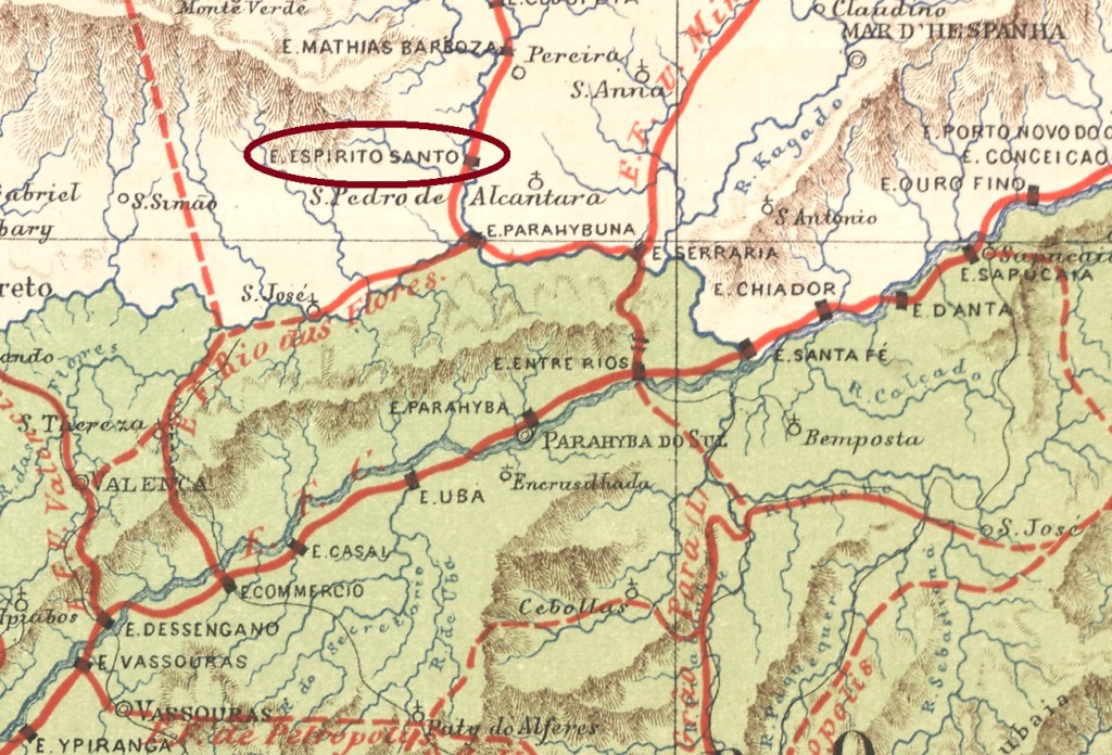
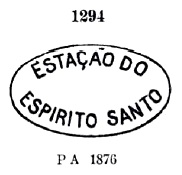
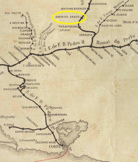
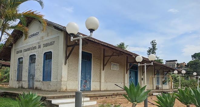
Espirito Santo railway station was opened in October 1875 by the E.F.D. Pedro II railway company (Central Line) and is located on the west bank of the Paraibuna in the Município Juiz de Fora, 250 km south of the provincial capital Ouro Preto. In July 1881, the station was renamed Sobragy in honour of Bento José Ribeiro Sobragy, who ruled the E.F.D. Pedro II for two terms.
The railway line was transferred to the E.F. Central d Brasil in 1889 and belonged to Rede Ferroviária Federal S.A. (estacoesferroviarias.com.br) from 1975 until its closure in 1996. Today, the tracks are still in place and the station building serves the municipality as a multi-purpose hall.
In 2023 (Photo: Catarina Gonçalves, on Google Maps)
The area around the railway station belonged to the Freguesia de Vargem Grande from September 1882 and to the Distrito de Ibitiguara from December 1943. Since November 1962, it has belonged to the Município de Belmiro Braga.
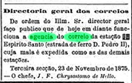
According to the Rio press, there was a railway station post office from November 1875:
Diario do Rio de Janeiro, 23/11/1875
R. Koester gives the year 1876 in Carimbologia XVIII, which could well correspond to the start of operations of the post office. The oldest postmark is EMG-1130a, which was given the no. 1294 by Paulo Ayres (Catálogo de Carimbos Brasil-Império, S. Paulo, 1937, 1942):
EMG-1130a (P.A. 1294) 1875-1876ff
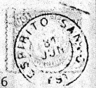
This was followed by EMG-1130b (fig. R. Koester, op. cit.), which also occurs in blue:
EMG-1130b (RK) 1877-1883ff
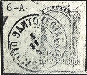
At the end of the Empire, when the station had long been called Sobragy, there was another stamp with the old name: EMG-1130c (fig. R. Koester), also in blue:
EMG-1130c (RK) 1885-1890Estações (…)do Rio de Janeiro, São Paulo e Minas Geraes, 1880
Andere Namen: Sobragy (1881)
Der Bahnhof Espirito Santo wurde im Oktober 1875 von der Eisenbahngesellschaft E.F.D. Pedro II (Central-Linie) eröffnet und liegt am Westufer des Paraibuna im Município Juiz de Fora, 250 km südlich der Provinzhauptstadt Ouro Preto. Im Juli 1881 wurde der Bahnhof in Sobragy umbenannt, zu Ehren von Bento José Ribeiro Sobragy, der die E.F.D. Pedro II während zwei Amtszeiten regierte.
Die Bahnlinie ging 1889 an die E.F. Central d Brasil über und gehörte von 1975 bis zu ihrer Schließung 1996 der Rede Ferroviária Federal S.A. (estacoesferroviarias.com.br). Heute sind die Gleise noch vorhanden, das Bahnhofsgebäude dient der Gemeinde als Mehrzweckhalle.
2023 (Foto: Catarina Gonçalves, auf Google Maps)
Das Gebiet um den Bahnhof gehörte ab September 1882 zur Freguesia de Vargem Grande und ab Dezember 1943 zum Distrito de Ibitiguara. Seit November 1962 gehört es zum Município de Belmiro Braga.
Wie die Presse von Rio berichtete, gab es ab November 1875 ein Bahnhofspostamt:
Diario do Rio de Janeiro, 23.11.1875
R. Koester gibt das Jahr 1876 in Carimbologia XVIII an, was wohl dem Betriebsbeginn des Postamtes entsprechen könnte. Der älteste Stempel ist EMG-1130a, der von Paulo Ayres (Catálogo de Carimbos Brasil-Império, S. Paulo, 1937, 1942) die Nr. 1294 erhielt:
EMG-1130a (P.A. 1294) 1875-1876ff
Es folgte EMG-1130b (Abb. R. Koester, op. cit.), der auch in blau erhältlich ist:
EMG-1130b (RK) 1877-1883ff
Am Ende des Kaiserreichs, als der Bahnhof längst Sobragy hieß, gab es noch einen weiteren Stempel mit dem alten Namen: EMG-1130c (Abb. R. Koester), ebenfalls in blau vorkommend: