Categories
Carimbologia C-D

Cotegipe, Bahia (CBA-0325)

Villiers de l’Ile Adam: Carta (…) da Provincia da Bahia, 1848

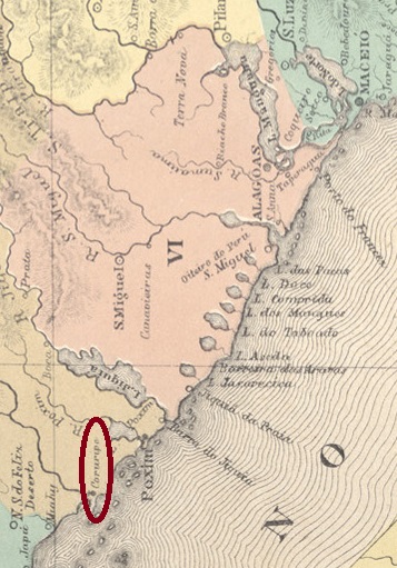
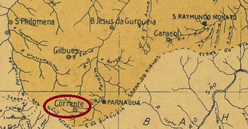
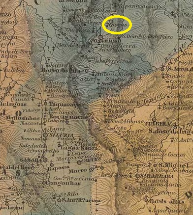
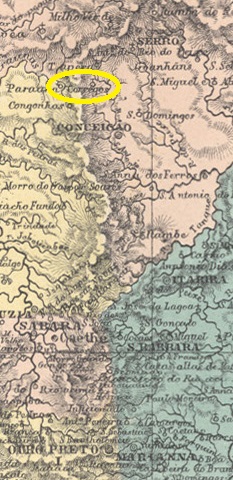
This locality in the state of Bahia is often confused with today’s Município de Cotegipe (formerly Campo Largo and Avaí), which lies over 800 kilometres to the west. Our Cotegipe is a former freguesia of the Vila de Salvador, which has been a district of the metropolis since August 1892. The word cotegipe means river of the agutis in Tupi-Guarani. In the empire, there was a Senator Barão de Cotegipe, alias João Mauricio Wanderley (1815-1889), who was born in what is now Bahia, but he only received this title in 1860 and therefore probably has no direct connection to this place.

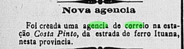
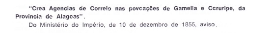
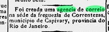
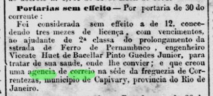
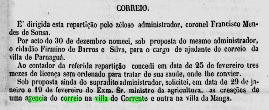
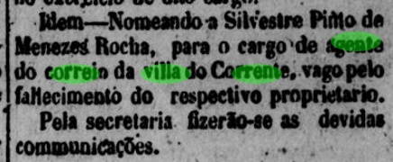
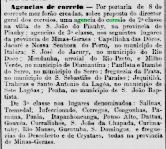
Reinhold Koester writes in Carimbologia XIV that there had been a post office there since May 1889. This is confirmed by the postal bulletin of the following month:

Boletim Postal No. 2/June 1889

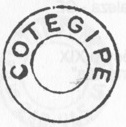
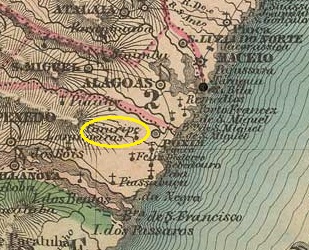
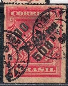
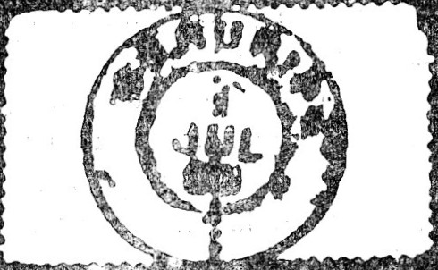
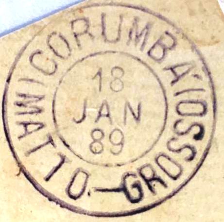
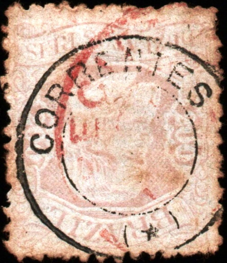
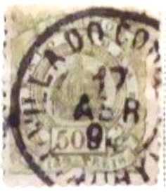
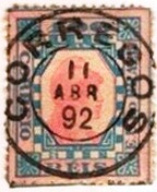
The oldest postmark so far is CBA-0325a, it will already be republican and was presented by Cicero A. de Almeida in Carimbos Postais – século XIX (Rio de Janeiro, 1989) under no. 774:

CBA-0325a (MPT-774)
Estado da Bahia, 1913

Dieser Ort im Bundesstaat Bahia wird oft mit dem heutigen Município de Cotegipe (ehemals Campo Largo und Avaí) verwechselt, das über 800 km weiter westlich liegt. Unser Cotegipe ist eine ehemalige Freguesia der Vila de Salvador, die seit August 1892 ein Stadtteil der Metropole ist. Das Wort cotegipe bedeutet auf Tupi-Guarani Fluss der Agutis. Im Kaiserreich gab es einen im heutigen Bahia geborenen Senator Barão de Cotegipe alias João Mauricio Wanderley (1815-1889), der diesen Titel allerdings erst 1860 erhielt und daher wohl keinen direkten Bezug zu diesem Ort hat.

Reinhold Koester schreibt in Carimbologia XIV, dass es dort seit Mai 1889 ein Postamt gab. Dies wird durch das Postbulletin des folgenden Monats bestätigt:

Boletim Postal Nr. 2/Juni 1889

Der bisher älteste Poststempel ist CBA-0325a, er wird bereits republikanisch sein und wurde von Cicero A. de Almeida in Carimbos Postais – século XIX (Rio de Janeiro, 1989) unter der Nr. 774 vorgestellt:

CBA-0325a (MPT-774)
Categories
Carimbologia C-D

Costa Pinto (train station/Bahnhof), São Paulo (CSP-0390)

Cia. Sorocabana e Ytuana, 1898 (IBGE)

The Costa Pinto railway station was opened in 1888 by the Cia. Ytuana de Estradas de Ferro and was located on the west bank of the Corumbataí in the Município de Piracicaba, 170 kilometres northwest of the provincial capital of São Paulo. The name commemorates Antonio Costa Pinto e Silva (1826-1887), who was president of the province of São Paulo from 1870-71.

1980 (Photo: José Pinto Siqueira Jr, on estacoesferroviarias.com.br)
2020 (Photo: Saulo Cabral on estacoesferroviarias.com.br)

The railway line went to the Cia. União Sorocabana e Ytuana in 1892, to the Sorocabana Railway in 1907 and belonged to E.F. Sorocabana from 1919 until it was closed in 1966. Today, the tracks and station building have long since disappeared and the entire site is the headquarters of the chemical giant enterprise Raízen.

As reported in the regional press, there had been a post office at the station since July 1888:

Correio Paulistano, 31/07/1888

No imperial postmark has ever been seen from this railway station.

Google Maps

Der Bahnhof Costa Pinto wurde 1888 von der Cia. Ytuana de Estradas de Ferro eröffnet und liegt am Westufer des Corumbataí im Município de Piracicaba, 170 km nordwestlich der Provinzhauptstadt São Paulo. Der Name erinnert an Antonio Costa Pinto e Silva (1826-1887), der 1870-71 Präsident der Provinz São Paulo war.

1980 (Foto: José Pinto Siqueira Jr, auf estacoesferroviarias.com.br)
2020 (Foto: Saulo Cabral auf estacoesferroviarias.com.br)

Die Bahnlinie ging 1892 an die Cia. União Sorocabana e Ytuana, 1907 an die Sorocabana Railway und gehörte von 1919 bis zur Stilllegung 1966 der E.F. Sorocabana. Heute sind Gleise und Bahnhofsgebäude längst verschwunden, das gesamte Gelände ist Sitz des Chemieriesen Raízen.

Wie die regionale Presse berichtete, gab es am Bahnhof seit Juli 1888 ein Postamt:

Correio Paulistano, 31.07.1888

Bisher wurde kein kaiserlicher Poststempel von diesem Bahnhof gesehen.

Categories
Carimbologia C-D

Coruripe/Cururipe, Alagoas (CAL-0055)

Villiers de l’Ile Adam: Carta (…) das Provincias de Pernambuco, Alagoas e Sergipe, 1848

The history of the settlement began around 1726, when colonists settled on the northern shore of the Coruripe estuary in the Atlantic Ocean, almost 90 kilometres southwest of the future provincial capital of Maceió. However, the area is still famous today for an earlier event: in June 1556, a ship carrying Brazil’s first bishop, Pero Fernandes Sardinha, from Salvador to Rio ran aground off the coast. Everyone on board was killed and eaten by the Caeté Indians.

Sardinha monument in Salvador, 2005 (Photo: Alex@Eddy, Wikipedia)

The locality became in June 1866 the Vila de N. Sra. da Conceição do Coruripe (also spelt Cururipe) and was granted town charter in May 1892.

The local post office was created in December 1855, as Nova Monteiro writes in Administrações e Agencias Postaes do Brasil Imperio (Brasil Filatelico/RJ, 1934-5; reprint SPP 1994-1999) and Aureo G. Santos confirms in Agências de Correio Criadas e Suprimidas 1851, 1855, 1856 e 1857 (Brasil Filatélico 181, Rio de Janeiro, 1977):

Aureo G. Santos (op. cit.)

However, Aldo Cardoso writes in Contribuição para a História dos Correios de Alagoas (Maceió, 1969) that this agency was only opened in 1866 and that until then the postal duties were carried out by the local tax office (Coletoria).

Cardoso also showed the oldest postmark to date, CAL-0055b:

CAL-0055b (AC) 1878ff-ca. 1888

Towards the end of the 19th century, CAL-0055c also appeared (image from the Internet):

CAL-0055c (EB) 1890ff-1904
Atlas do Imperio do Brasi, 1868

Die Geschichte der Siedlung begann um 1726, als sich Kolonisten am Nordufer der Coruripe-Mündung in den Atlantik niederließen, knapp 90 km südwestlich der späteren Provinzhauptstadt Maceió. Berühmt ist die Gegend aber bis heute durch ein früheres Ereignis: Im Juni 1556 strandete vor der Küste ein Schiff, das den ersten Bischof Brasiliens, Pero Fernandes Sardinha, von Salvador nach Rio brachte. Alle an Bord wurden von den Caeté-Indianern getötet und verspeist.

Sardinha-Denkmal in Salvador, 2005 (Foto: Alex@Eddy, Wikipedia)

Der Ort wurde im Juni 1866 unter dem Namen Vila de N. Sra. da Conceição do Coruripe (auch Cururipe geschrieben) selbstständig und erhielt im Mai 1892 das Stadtrecht.

Das örtliche Postamt wurde im Dezember 1855 gegründet, wie Nova Monteiro in Administrações e Agencias Postaes do Brasil Imperio (Brasil Filatelico/RJ, 1934-5; Nachdruck SPP 1994-1999) schreibt und Aureo G. Santos in Agências de Correio Criadas e Suprimidas 1851, 1855, 1856 e 1857 (Brasil Filatélico 181, Rio de Janeiro, 1977) bestätigt:

Aureo G. Santos (op. cit.)

Aldo Cardoso schreibt jedoch in Contribuição para a História dos Correios de Alagoas (Maceió, 1969), dass diese Agentur erst 1866 eröffnet wurde und die Postaufgaben bis dahin von der lokalen Finanzbehörde (Coletoria) wahrgenommen wurden.

Cardoso zeigte auch den bisher ältesten Poststempel CAL-0055b:

CAL-0055b (AC) 1878ff-ca. 1888

Gegen Ende des 19. Jahrhunderts erschien auch CAL-0055c (Abbildung aus dem Internet):

CAL-0055c (EB) 1890ff-1904
Categories
Carimbologia C-D

Corumbatahy (train station/Bahnhof), São Paulo (CSP-0385)

Cia. Paulista de Estradas de Ferro

Corumbatahy station was opened in October 1884 by the railway company E.F. do Rio Claro (Analandia branch) and was located on the west bank of the Corumbatahy in the Município de Rio Claro, 210 km north-west of the provincial capital of São Paulo. The line was handed over to the Cia. Paulista de Estradas de Ferro in 1892 and closed in 1966. Today, the tracks and the station building have been demolished.

In 1918 (Photo: Archive Cia. Paulista apud estacoesferroviarias.com.br)
around 1950 (Photo: corumbatahy.com.br apud estacoesferroviarias.com.br)

The area around the railway station became a district of the municipality of Rio Claro in November 1919 and has been Município de Corumbataí, in its current spelling, since December 1948. The name comes from the Tupi-Guarani language and means River of the Curimbatás. This name refers to fish from the barbel family (Prochilodontidae), which are found throughout Brazil and are also called curimatã or grumatã:

Prochilodus lineatus (Valenciennes, 1837)

As R. Koester writes in Carimbologia XIV, there has been a post office at the railway station since January 1886. The imperial postmark is CSP-0385a (collect. Fuad Ferreira Fo.):

CSP-0385a (FF) 1886-1894
Google Maps

Der Bahnhof Corumbatahy wurde im Oktober 1884 von der Eisenbahngesellschaft E.F. do Rio Claro (Abzweig Analandia) eröffnet und lag am Westufer des Corumbatahy im Município de Rio Claro, 210 km nordwestlich der Provinzhauptstadt São Paulo. Die Strecke wurde 1892 an die Cia. Paulista de Estradas de Ferro übergeben und 1966 stillgelegt. Heute sind die Gleise und das Bahnhofsgebäude abgerissen.

1918 (Foto: Archiv Cia. Paulista apud estacoesferroviarias.com.br)
ca. 1950 (Foto: corumbatahy.com.br apud estacoesferroviarias.com.br)

Das Gebiet um den Bahnhof wurde im November 1919 ein Bezirk der Gemeinde Rio Claro und ist seit Dezember 1948 Município de Corumbataí, in der heutigen Schreibweise. Der Name stammt aus der Tupi-Guarani-Sprache und bedeutet Fluss der Curimbatás. Dieser Name bezieht sich auf Fische aus der Familie der Barbensalmler (Prochilodontidae), die in ganz Brasilien vorkommen und auch curimatã oder grumatã genannt werden:

Prochilodus lineatus (Valenciennes, 1837)

Wie R. Koester in Carimbologia XIV schreibt, gab es am Bahnhof ein Postamt seit Januar 1886. Der kaiserliche Poststempel ist CSP-0385a (Samml. Fuad Ferreira Fo.):

CSP-0385a (FF) 1886-1894
Categories
Carimbologia C-D

Corumbá, Mato Grosso (CMT-0010)

Atlas do Imperio do Brasil, 1868

Other names: N. Sra. da Conceição de Albuquerque, Santa Cruz de Corumbá

The history of this place begins in April 1838 with the founding of the Distrito de N. Sra. da Conceição de Albuquerque, 1000 kilometres south of the provincial capital Cuiabá. In July 1850 it was elevated to the status of a Vila, which was occupied by the Paraguayans between 1865 and 1870 during the Triple Alliance War. After that, the Vila de Albuquerque was re-established in October 1871, which became the city of Sta. Cruz de Corumbá in November 1878. Corumbá has been in the state of Mato Grosso do Sul since 1979.

As can be seen from the list of imperial post offices (Tabella das Agencias do Correio do Imperio, Rio de Janeiro, 1885), there had been a post office there since 1861. All postmarks with the place name Corumbá can be dated from 1870, i.e. after the war. The first to appear was CMT-0010a (fig. Claudio Coelho and R. Baldassare):

CMT-0010a (CC-RB) 1871-1881

There came afterwards CMT-0010b (ill. from the internet):

CMT-0010b (WA) 1878ff-1891

R. Koester also shows the seal cancel CMT-0010c in Carimbologia XIV:

CMT-0010c (RK)

And the philatelist Claudio Coelho has also shown us a mute cancel from there:

1871 (CC)
Villiers de l’Ile Adam: Carta (…) da Provincia do Matto Grosso, 1850

Andere Namen: N. Sra. da Conceição de Albuquerque, Santa Cruz de Corumbá

Die Geschichte dieses Ortes beginnt im April 1838 mit der Gründung des Distrito de N. Sra. da Conceição de Albuquerque, 1000 km südlich der Provinzhauptstadt Cuiabá. Im Juli 1850 erfolgte die Erhebung zur Vila, die zwischen 1865 und 1870 während des Tripel-Allianz-Krieges von den Paraguayern besetzt wurde. Nach dem Krieg wurde im Oktober 1871 die Vila de Albuquerque neu gegründet, die im November 1878 zur Stadt Sta. Cruz de Corumbá wurde. Seit 1979 liegt Corumbá im Bundesstaat Mato Grosso do Sul.

Wie aus dem Verzeichnis der kaiserlichen Postämter (Tabella das Agencias do Correio do Imperio, Rio de Janeiro, 1885) hervorgeht, gab es dort seit 1861 ein Postamt. Alle Poststempel mit dem Ortsnamen Corumbá können ab 1870, also nach dem Krieg, datiert werden. Als erster erschien CMT-0010a (Abb. Claudio Coelho und R. Baldassare):

CMT-0010a (CC-RB) 1871-1881

Es kam danach CMT-0010b (Abb. aus dem Internet):

CMT-0010b (WA) 1878ff-1891

R. Koester zeigt in Carimbologia XIV auch den Siegelstempel CMT-0010c:

CMT-0010c (RK)

Und der Philatelist Claudio Coelho hat uns auch einen stummen Stempel von dort gezeigt:

1871 (CC)
Categories
Carimbologia C-D

Corumbá, Goiás (CGO-0050)

Atlas do Imperio do Brasil, 1868

Other names: Corumbá de Goiás (1943)

The Freguesia de N. Sra. da Penha de França de Corumbá was founded in December 1840, belonged to the Vila de Meia Ponte (today Pirenópolis) and was located on the west bank of the Corumbá, 190 km east of the provincial capital Goyaz (today Goiás Velho). The village was elevated to vila twice: in February 1849 and July 1875; in between it was again a Freguesia of Meia Ponte from August 1863. Since July 1902 it has been a town, which has been called Corumbá de Goiás since December 1943, to avoid confusion with the town of the same name in the state of Mato Grosso do Sul.

Two foundation dates were found for the local post office. The first was in August 1853, as Nova Monteiro writes in Administrações e Agencias Postaes do Brasil Imperio (Brasil Filatelico/RJ, 1934-5; reprint SPP 1994-1999) and is confirmed by the press in Rio:

Diario do Rio de Janeiro, 14/09/1853

Then again in September 1854, as can also be read in Nova Monteiro (op. cit.) and is also mentioned by R. Koester in Carimbologia XIV. Koester also shows an illustration of the first postmark CGO-0050a:

CGO-0050a (RK) 1866ff

It was followed by CGO-0050b, known through Paulo Ayres (Catálogo de Carimbos Brasil-Império, S. Paulo, 1937, 1942):

CGO-0050b (P.A. 1599) 1877ff

Towards the end of the 19th century, CGO-0050c (fig. Claudio Coelho) has also appeared:

CGO-0050c (CC) 1890-1907
Villiers de l’Ile Adam: Carta (…) da Provincia de Goyaz, 1849

Andere Namen: Corumbá de Goiás (1943)

Die Freguesia de N. Sra. da Penha de França de Corumbá wurde im Dezember 1840 gegründet, gehörte zur Vila de Meia Ponte (heute Pirenópolis) und lag am Westufer des Corumbá, 190 km östlich der Provinzhauptstadt Goyaz (heute Goiás Velho). Der Ort wurde zweimal zur Vila erhoben: im Februar 1849 und im Juli 1875; dazwischen war er ab August 1863 wieder eine Freguesia von Meia Ponte. Seit Juli 1902 ist es eine Stadt, die seit Dezember 1943 Corumbá de Goiás heißt, um Verwechslungen mit der gleichnamigen Stadt im Bundesstaat Mato Grosso do Sul zu vermeiden.

Für das örtliche Postamt wurden zwei Gründungsdaten gefunden. Erstmals im August 1853, wie Nova Monteiro in Administrações e Agencias Postaes do Brasil Imperio (Brasil Filatelico/RJ, 1934-5; Nachdruck SPP 1994-1999) schreibt und von der Presse in Rio bestätigt wird:

Diario do Rio de Janeiro, 14.09.1853

Dann wieder im September 1854, wie auch bei Nova Monteiro (op. cit.) zu lesen ist und auch von R. Koester in Carimbologia XIV erwähnt wird. Koester zeigt auch eine Abbildung des ersten Poststempels CGO-0050a:

CGO-0050a (RK) 1866ff

Ihm folgte CGO-0050b, bekannt durch Paulo Ayres (Catálogo de Carimbos Brasil-Império, S. Paulo, 1937, 1942):

CGO-0050b (P.A. 1599) 1877ff

Ende des 19. Jahrhunderts kam auch CGO-0050c (Abb. Claudio Coelho):

CGO-0050c (CC) 1890-1907
Categories
Carimbologia C-D

Correntezas, Rio de Janeiro (CRJ-0405)

Atlas do Imperio do Brasil, 1868

Other names: Maratuan; Aldeia Velha (1938, 1990), Silva Jardim, Quartéis

N. Sra. do Amparo das Correntezas had been since June 1844 a district of Vila de Capivari on the north bank of the São João, 130 km north-east of the capital Rio de Janeiro. It remained so despite being renamed several times: Maratuan in October 1904, Aldeia Velha in March 1938, Silva Jardim in December 1938, Quartéis five years later and finally Aldeia Velha again in June 1990. Since December 1943, the Vila de Capivari has also been called Município de Silva Jardim.

R. Koester writes in Carimbologia XIV that there has been a post office there since February 1883, but this is probably a transcription error, as the regional press reported the founding of the local postal agency exactly one year later:

Gazeta da Tarde, 13/02/1884

According to Paulo Novaes (agenciaspostais.com.br), this post office was already closed in July 1884, to be reopened in neighbouring Rio Morto.

As the regional press does not report on the relocation of the post office but on the invalidity of its establishment, the agency may not have started operations at all:

Jornal do Commercio, 31.07.1884

So far no postmark from Correntezas has been found; it must be very rare, if it exists at all.

Almanak Laemmert, 1892

Andere Namen: Maratuan; Aldeia Velha (1938, 1990), Silva Jardim, Quartéis

N. Sra. do Amparo das Correntezas war seit Juni 1844 ein Distrikt von Vila de Capivari am Nordufer des São João, 130 km nordöstlich der Hauptstadt Rio de Janeiro. So blieb es trotz mehrfacher Umbenennungen: im Oktober 1904 in Maratuan, im März 1938 in Aldeia Velha, im Dezember 1938 in Silva Jardim, fünf Jahre später in Quartéis und schließlich im Juni 1990 wieder in Aldeia Velha. Seit Dezember 1943 heißt auch die Vila de Capivari Município de Silva Jardim.

R. Koester schreibt in Carimbologia XIV, dass es dort seit Februar 1883 ein Postamt gab, was jedoch ein Abschreibfehler sein dürfte, da die regionale Presse genau ein Jahr später die Gründung der örtlichen Postagentur meldete:

Gazeta da Tarde, 13.02.1884

Laut Paulo Novaes (agenciaspostais.com.br) wurde dieses Postamt bereits im Juli 1884 geschlossen, um im benachbarten Rio Morto wieder eröffnet zu werden.

Da die regionale Presse nicht über eine Verlegung des Postamts sondern über die Ungültigkeit seiner Entstehung berichtet, hat die Agentur den Betrieb möglicherweise gar nicht aufgenommen:

Jornal do Commercio, 31.07.1884

Bisher wurde kein Poststempel aus Correntezas gefunden, er muss sehr selten sein, wenn überhaupt existent.

Categories
Carimbologia C-D

Correntes, Pernambuco (CPE-0215)

Villiers de l’Ile Adam: Carta (…) das Provincias de Pernambuco, Alagoas e Sergipe, 1848

The Vila de N. Sra. da Conceição de Correntes was founded in July 1848 on the north bank of the Mundaú, 250 kilometres southwest of the provincial capital Recife. It was demoted to the freguesia of Vila de Garanhuns in May 1849, but regained the status of a vila in May 1879. Correntes has been a town since July 1909.

As can be seen from the list of imperial post offices (Tabella das Agencias do Correio do Imperio, Rio de Janeiro, 1885), there was to be a post office there from 1876. However, this only started operating in February of the following year, as reported in the regional press:

Diario de Pernambuco, 22/02/1877

The imperial postmark is the French type CPE-0215a (image by Claudio Coelho):

CPE-0215a (CC) 1882ff-1887
Carta Corographica da Provincia de Pernambuco, 1880

Die Vila de N. Sra. da Conceição de Correntes wurde im Juli 1848 gegründet und liegt am Nordufer des Mundaú, 250 km südwestlich der Provinzhauptstadt Recife. Sie wurde im Mai 1849 zur Freguesia der Vila de Garanhuns degradiert, erhielt aber im Mai 1879 den Status einer Vila zurück. Seit Juli 1909 ist Correntes eine Stadt.

Wie aus dem Verzeichnis der kaiserlichen Postämter (Tabella das Agencias do Correio do Imperio, Rio de Janeiro, 1885) hervorgeht, sollte es dort ab 1876 ein Postamt geben. Dieses nahm jedoch erst im Februar des folgenden Jahres seinen Betrieb auf, wie die regionale Presse berichtete:

Diario de Pernambuco, 22.02.1877

Der kaiserliche Poststempel ist der französische Typ CPE-0215a (Abb. Claudio Coelho):

CPE-0215a (CC) 1882ff-1887
Categories
Carimbologia C-D

Corrente, Piauí (CPI-0065)

Atlas do Imperio do Brasil, 1868

See also Villa do Corrente (VPI-0066)

The parish of N. Sra da Conceição do Corrente was founded in August 1860 in the Município Parnaguá on the north bank of the river Corrente, 840 kilometres south of the provincial capital Teresina. It was elevated to the status of Vila in December 1872.

The directory of imperial post offices (Tabella das Agencias do Correio do Imperio, Rio de Janeiro, 1885) states that there had been a post office there since 1883. However, this must either be a transcription error or a reopening, as a postal agency was already applied for there in April 1879…

A Imprensa/PI/ 28.04.1879

… and in February 1880 a postal employee is named there after the death of the predecessor:

A Imprensa/PI/ 25/02/1880

The oldest postmark here is VPI-0066a (image from the Internet):

VPI-0066a (EB) 1894
Arthur D. Ribeiro: Estado do Piauhy, 1924

Siehe auch Villa do Corrente (VPI-0066)

Die Pfarrei N. Sra da Conceição do Corrente wurde im August 1860 im Município Parnaguá am Nordufer des Flusses Corrente, 840 km südlich der Provinzhauptstadt Teresina, gegründet. Die Erhebung zur Vila erfolgte im Dezember 1872.

Im Verzeichnis der kaiserlichen Postämter (Tabella das Agencias do Correio do Imperio, Rio de Janeiro, 1885) ist zu lesen, dass es dort seit 1883 ein Postamt gab. Dabei muss es sich aber entweder um einen Abschreibfehler oder um eine Wiedereröffnung handeln, denn bereits im April 1879 wurde dort eine Postagentur beantragt…

A Imprensa/PI/ 28.04.1879

… und im Februar 1880 wird dort nach dem Tod des Vorgängers ein Postangestellter genannt:

A Imprensa/PI/ 25.02.1880

Der älteste Poststempel hier ist VPI-0066a (Abbildung aus dem Internet):

VPI-0066a (EB) 1894
Categories
Carimbologia C-D

Córregos, Minas Gerais (CMG-0900)

Villiers de l’Ile Adam: Carta (…) da Provincia de Minas Geraes, 1849

The freguesia de N. Sra da Apparecida dos Córregos was founded in May 1877, belonged to the Vila de Conceição do Serro and was located on the south bank of the Ribeirão de Sto. Antonio do Cruzeiro, 290 kilometres north of the provincial capital Ouro Preto. In December 1943, the village was incorporated as a district into the município de Conceição do Mato Dentro.

R. Koester writes in Carimbologia XIV that there had been a post office there since November 1881. This is confirmed by the press in Rio:

Jornal do Commercio/RJ, 12/11/1881

The imperial postmark is CMG-0900a (image from the Internet), which has so far only been seen with dates from the Republic:

CMG-0900a (EB) 1892
Atlas do Imperio do Brasil, 1868

Die Freguesia de N. Sra da Apparecida dos Córregos wurde im Mai 1877 gegründet, gehörte zur Vila de Conceição do Serro und lag am Südufer des Ribeirão de Sto. Antonio do Cruzeiro, 290 km nördlich der Provinzhauptstadt Ouro Preto. Im Dezember 1943 wurde der Ort als Distrikt in das Município de Conceição do Mato Dentro eingegliedert.

R. Koester schreibt in Carimbologia XIV, dass es dort seit November 1881 ein Postamt gab. Dies wird von der Presse in Rio bestätigt:

Jornal do Commercio/RJ, 12.11.1881

Der kaiserliche Poststempel ist CMG-0900a (Abbildung aus dem Internet), der bisher nur mit Daten aus der Republik gesehen wurde:

CMG-0900a (EB) 1892