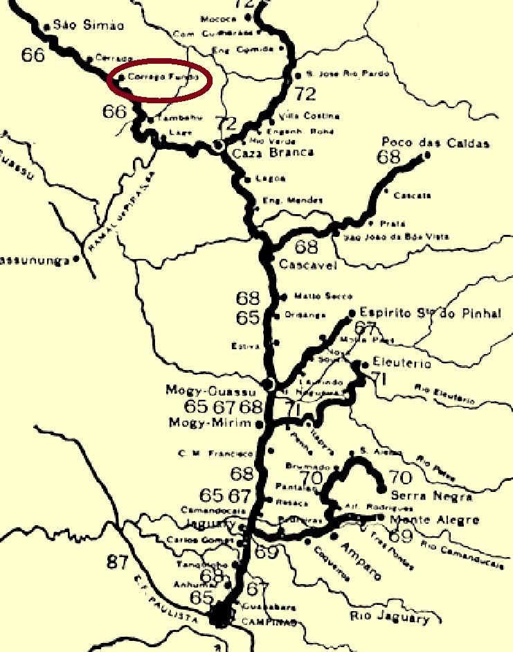
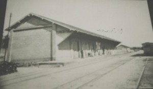
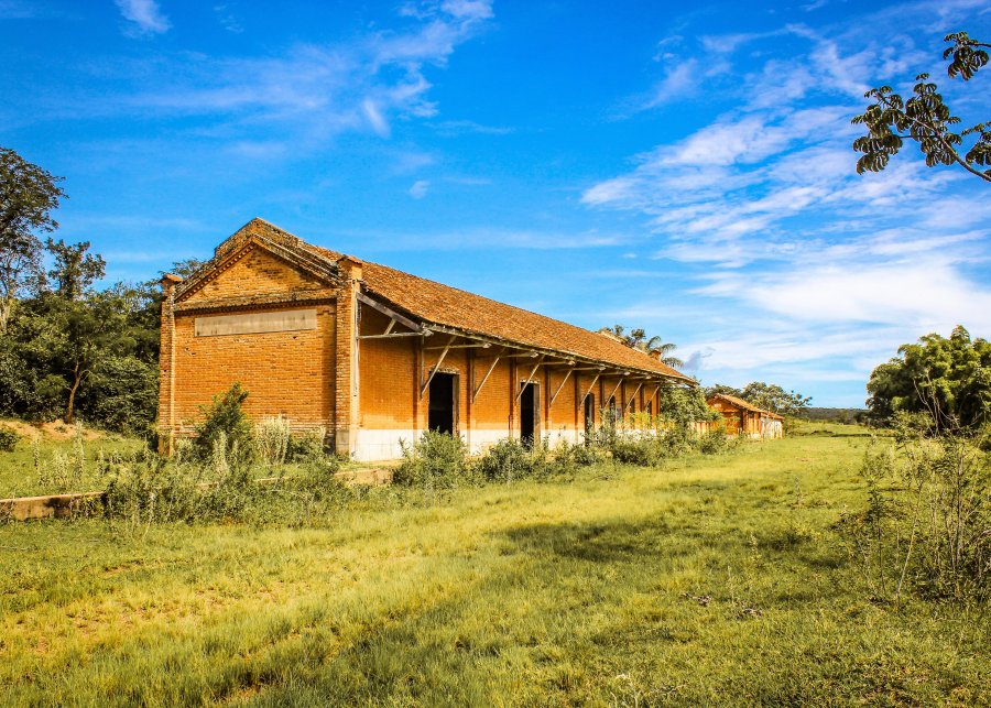
The Córrego Fundo (Deep Stream) railway station was opened in August 1882 by the Cia. Mogyana railway company (original main line) and was in the Município de São Simão, 270 km north of the provincial capital of São Paulo. It remained so until it was closed, except that the station has been in the Município de Tambaú since August 1898. Today, the tracks have disappeared, and the station building seems abandoned.
Around 1910 (Album Mogiana, apud estacoesferroviarias.com.br)In 2018 (Photo: Augusto Massaferro on estacoesferroviarias.com.br)
R. Koester writes in Carimbologia XIV that there has been a post office there since August 1886. No imperial postmark from the Córrego Fundo station has yet been found.
Google Maps
Der Bahnhof Córrego Fundo (Tiefer Bach) wurde im August 1882 von der Eisenbahngesellschaft Cia. Mogyana (ursprüngliche Hauptstrecke) eröffnet und lag im Município de São Simão, 270 km nördlich der Provinzhauptstadt São Paulo. Bis zur Stilllegung blieb es so, nur dass der Bahnhof seit August 1898 im Município de Tambaú liegt. Heute sind die Gleise verschwunden, das Bahnhofsgebäude wirkt verlassen.
um 1910 (Album Mogiana, apud estacoesferroviarias.com.br)2018 (Foto: Augusto Massaferro auf estacoesferroviarias.com.br)
R. Koester schreibt in Carimbologia XIV, dass es dort seit August 1886 ein Postamt gibt. Bisher wurde kein kaiserlicher Poststempel von der Station Córrego Fundo gefunden.
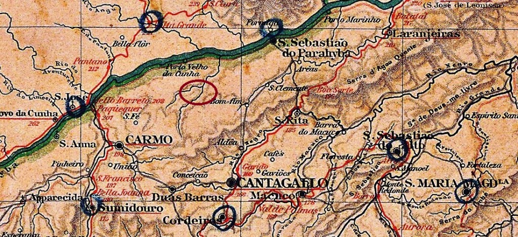
The chapel of S. Francisco de Salles do Córrego do Prata was consecrated in August 1855 and belonged to the Freguesia do Carmo of the Vila de Cantagallo, 200 kilometres north-east of the capital Rio de Janeiro. After Carmo became a Vila in October 1881, Córrego do Prata was added and declared a district in August 1890. This has remained the case to this day.
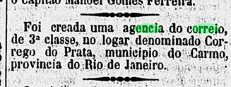
R. Koester writes in Carimbologia XIV that there has been a post office there since August 1885. This is confirmed by the regional press:
Diario de Noticias, 19/08/1885
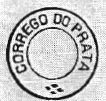
There is only one illustration of the first postmark CRJ-0400a, found at Koester (op. cit.):
CRJ-0400a (RK)
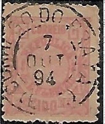
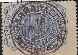
Its successor CRJ-0400b (image from the Internet) arrived before the end of the Empire:
CRJ-0400b (EB) 1889-1897Google Maps
Textaktualisierung am 20. Juli 2025
Die Kapelle S. Francisco de Salles do Córrego do Prata wurde im August 1855 geweiht und gehörte zur Freguesia do Carmo der Vila de Cantagallo, 200 km nordöstlich der Hauptstadt Rio de Janeiro. Nachdem Carmo im Oktober 1881 zur Vila wurde, kam Córrego do Prata dazu und wurde im August 1890 zum Distrikt erklärt. Dies ist bis heute so geblieben.
R. Koester schreibt in Carimbologia XIV, dass es dort seit August 1885 ein Postamt gab. Dies wird von der regionalen Presse bestätigt:
Diario de Noticias, 19.08.1885
Vom ersten Poststempel CRJ-0400a gibt es nur eine Abbildung aus Koester (op. cit.):
CRJ-0400a (RK)
Sein Nachfolger CRJ-0400b (Abb. aus dem Internet) wurde gegen Ende des Kaiserreichs verwendet:
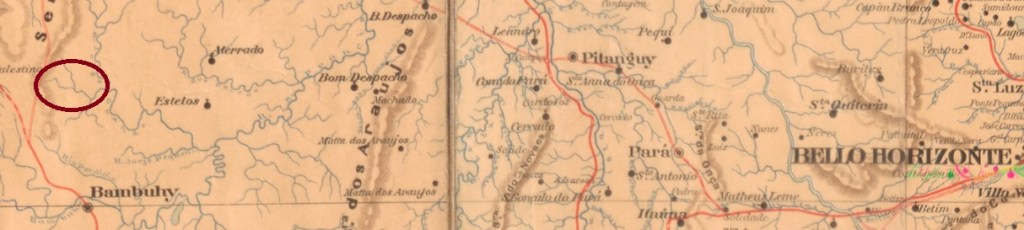
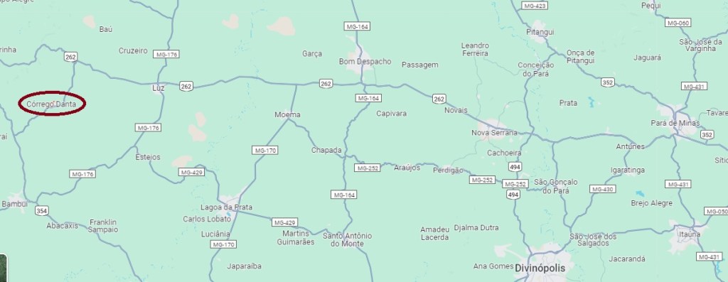
S. José de Córrego d’Antas was from July 1868 a district of the Vila de Dores do Indaiá, situated on the Tapir brook (Córrego d’Antas), 320 kilometres west of the provincial capital Ouro Preto. In September 1871, the district was assigned to the Vila de Patrocínio de Marmelada, and in November 1875 it was promoted to a freguesia, returning to Vila de Dores do Indaiá five years later. In September 1923, the name changed slightly to Córrego Danta when the village became a district of the Município de Luz. Córrego Danta has been an independent município since December 1948.
As Paula Sobrinho (História Postal de Minas Gerais, Belo Horizonte, 1997) and R. Koester (Carimbologia XIV) write, there had been a post office with the imperial postmark CMG-0905a there since July 1884 (fig. R. Koester, op. cit.):
CMG-0905a (RK) 1888Google Maps
Andere Namen: Córrego Danta (1923)
S. José de Córrego d’Antas war ab Juli 1868 ein Distrikt der Vila de Dores do Indaiá, gelegen am Fluss der Tapire (Córrego d’Antas), 320 km westlich der Provinzhauptstadt Ouro Preto. Im September 1871 wurde der Bezirk zur Vila de Patrocínio de Marmelada zugewiesen, im November 1875 stieg er zu einer Freguesia auf, die fünf Jahre später in Vila de Dores do Indaiá zurückkehrte. Im September 1923 änderte sich der Name geringfügig in Córrego Danta, als der Ort ein Distrikt des Município de Luz wurde. Seit Dezember 1948 ist Córrego Danta ein unabhängiges Município.
Wie Paula Sobrinho (História Postal de Minas Gerais, Belo Horizonte, 1997) und R. Koester (Carimbologia XIV) schreiben, gab es dort seit Juli 1884 ein Postamt mit dem kaiserlichen Poststempel CMG-0905a (Abb. R. Koester, op. cit.):
Carta da Republica dos Estados Unidos do Brazil, 1892
Other names: Castro Alves (1900)
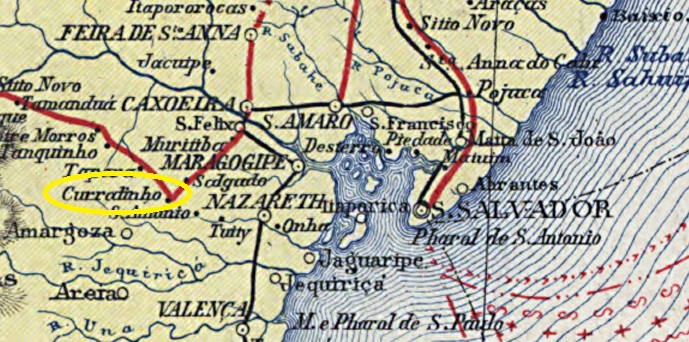
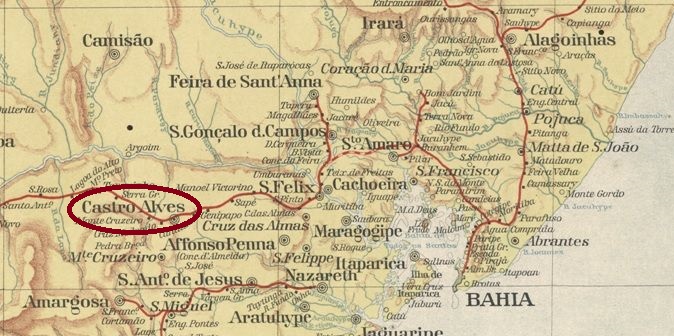
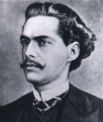
Among the places in the imperial province of Bahia that bore the name Curralinho (Little Corral), the Freguesia de N. Sra. da Conceição do Curralinho, founded in August 1873, was probably the only one to have its own post office. It belonged to the Vila de Cachoeira and was situated on a hill just under 200 kilometres west of the capital Salvador. In June 1880 it became a Vila itself and 15 years later a town, which has been Município de Castro Alves since July 1900. The name commemorates the poet and playwright Antonio de Castro Alves (1847-1871), who was born in Curralinho:
Castro Alves (Wikipedia)
As R. Koester writes in Carimbologia (XIV and XV), the post office had been in existence there since September 1874. The only postmark in the empire to date is CBA-0320a (fig. Claudio Coelho), which also exists in violet, blue and red:
CBA-0320a (CC) 1885-1895Estado da Bahia, 1913
Andere Namen: Castro Alves (1900)
Unter den Orten der kaiserlichen Provinz Bahia, die den Namen Curralinho (Kleiner Korral) trugen, war die im August 1873 gegründete Freguesia de N. Sra. da Conceição do Curralinho wohl der einzige, die über ein eigenes Postamt verfügte. Diese Freguesia gehörte zur Vila de Cachoeira und lag auf einem Hügel knapp 200 km westlich der Hauptstadt Salvador. Im Juni 1880 wurde es selbst zur Vila und 15 Jahre später zur Stadt erhoben, die seit Juli 1900 Município de Castro Alves ist. Der Name erinnert an den Dichter und Dramatiker Antonio de Castro Alves (1847-1871), der in Curralinho geboren wurde:
Castro Alves (Wikipedia)
Wie R. Koester in Carimbologia (XIV und XV) schreibt, gab es dort das Postamt seit September 1874. Der bisher einzige Poststempel im Kaiserreich ist CBA-0320a (Abb. Claudio Coelho), den es auch in violett, blau und rot gibt:
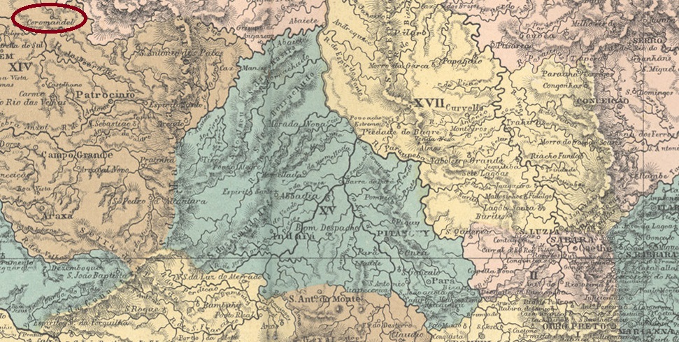
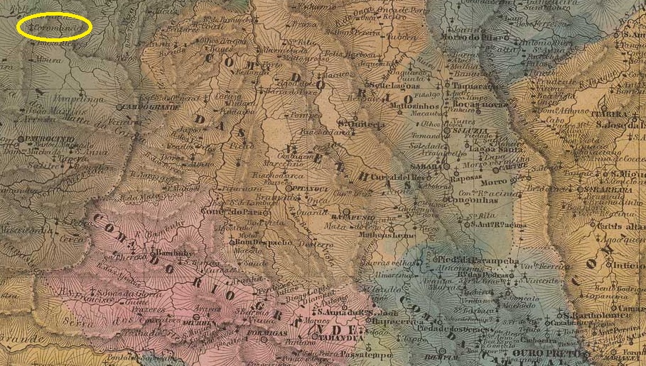
N. Sra. do Patrocinio de Coromandel (also spelt Corumandel) was from September 1870 a freguesia of the Vila do Patrocínio, located 570 km north-west of the provincial capital Ouro Preto. In October 1882, the town was elevated to a Vila, but lost this status again in November 1891 when it was downgraded to a district. Coromandel has only been an independent município again since September 1923. The name is a reminder of earlier Portuguese settlers, descendants of seamen who travelled the Coromandel coast of India.
R. Koester (Carimbologia XIV) and Paula Sobrinho (História Postal de Minas Gerais, Belo Horizonte, 1997) write that there was a post office there from April 1873. The oldest postmark could be CMG-0985a, which is described by P. Ayres (Catálogo de Carimbos Brasil-Império, S. Paulo, 1937, 1942) as an ordinary circular postmark, unfortunately without illustration. R. Koester also shows a handwritten cancellation from Coromandel, as an indication that the official postmark did not arrive in time:
1873ff (RK)Villiers de l’Ile Adam: Carta (…) da Provincia de Minas Geraes, 1849
N. Sra. do Patrocinio de Coromandel (auch Corumandel geschrieben) war ab September 1870 eine Freguesia der Vila do Patrocínio, 570 km nordwestlich der Provinzhauptstadt Ouro Preto gelegen. Im Oktober 1882 wurde der Ort zur Vila erhoben, verlor diesen Status aber im November 1891 wieder, als er zum Distrikt herabgestuft wurde. Erst seit September 1923 ist Coromandel wieder ein eigenständiges Município. Der Name soll an frühere portugiesische Siedler erinnern, die Nachfahren von Seefahrern waren, die die Coromandel-Küste Indiens bereisten.
R. Koester (Carimbologia XIV) und Paula Sobrinho (História Postal de Minas Gerais, Belo Horizonte, 1997) schreiben, dass es dort ab April 1873 ein Postamt gab. Der älteste Poststempel könnte CMG-0985a sein, der von P. Ayres (Catálogo de Carimbos Brasil-Império, S. Paulo, 1937, 1942) als gewöhnlicher Kreisstempel beschrieben wird, leider ohne Abbildung. R. Koester zeigt auch eine handschriftliche Entwertung aus Coromandel, als Indiz dafür, dass der offizielle Poststempel damals nicht rechtzeitig eintraf:
Villiers de l’Ile Adam: Carta (…) da Provincia do Maranhão, 1850
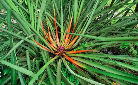
Coroatá, Caraguatá or Gravatá are Brazilian names for various bromeliads such as Bromelia pinguin:
Bromelia pinguin, L. (Wikipedia)
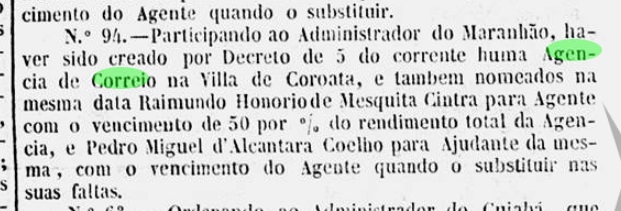
N. Sra. da Piedade de Coroatá was a freguesia of the Vila de Caxias on the Itapicuru River, 250 km south of the later provincial capital S. Luís do Maranhão. In November 1843, it was elevated to a vila and in April 1920 to a town.
According to Rio’s official press, there had been a post office there since November 1846
Gazeta Official/RJ, 25.11.1846
According to R. Koester (Carimbologia XIV), CMA-0105a was the first postmark, which it is said to be very rare:
CMA-0105a (RK) 1846ff
It is possible that this postmark quickly became unusable, as the stamps were soon cancelled by hand:
1846ff (fig. Roberto Assef Jr.)
The next cancellation is CMA-0105b (ill. José A. Junges), in the form typical for Maranhão:
CMA-0105b (JJ) 1850ff-1876ff
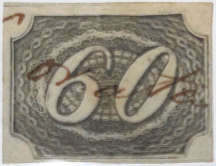
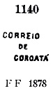
It was followed by CMA-0105c, which was given the no. 1140 by P. Ayres (Catálogo de Carimbos Brasil-Império, S. Paulo, 1937, 1942):
CMA-0105c (P.A. 1140) 1878ff
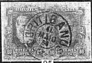
R. Koester (op. cit.) describes the next cancellation CMA-0105d as a double circle, which appeared from about 1880, unfortunately without illustration.
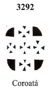
There is also a mute cancellation from the imperial Coroatá, which was given the no. 3292 by James Dingler and Klerman W. Lopes (Mute Cancellations of the Brazil Empire / Carimbos Mudos do Brasil Império, Brazil Philatelic Association, Rio de Janeiro, 2000):
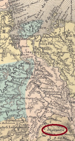
BPA 3292, 1878ffAtlas do Imperio do Brasil, 1868
Coroatá, Caraguatá oder auch Gravatá sind brasilianische Bezeichnungen für verschiedene Bromeliengewächse wie z.B. Bromelia pinguin:
Bromelia pinguin, L. (Wikipedia)
N. Sra. da Piedade de Coroatá war eine Freguesia der Vila de Caxias am Itapicuru-Fluss, 250 km südlich der späteren Provinzhauptstadt S. Luís do Maranhão. Im November 1843 wurde es zur Vila und im April 1920 zur Stadt erhoben.
Wie aus der offiziellen Presse von Rio hervorgeht, gab es dort seit November 1846 ein Postamt
Gazeta Official/RJ, 25.11.1846
Nach R. Koester (Carimbologia XIV) war CMA-0105a der erste Poststempel, der sehr selten sein soll:
CMA-0105a (RK) 1846ff
Möglicherweise wurde dieser Stempel schnell unbrauchbar, da die Marken bald von Hand entwertet wurden:
1846ff (Abb. Roberto Assef Jr.)
Der nächste Stempel ist CMA-0105b (Abb. José A. Junges), in der für Maranhão typischen Form:
CMA-0105b (JJ) 1850ff-1876ff
Ihm folgte CMA-0105c, der von P. Ayres (Catálogo de Carimbos Brasil-Império, S. Paulo, 1937, 1942) die Nr. 1140 erhielt:
CMA-0105c (P.A. 1140) 1878ff
R. Koester (op. cit.) beschreibt den nächsten Stempel CMA-0105d als einen Doppelkreis, der ab ca. 1880 auftrat, leider ohne Abbildung.
Aus dem kaiserlichen Coroatá stammt auch ein stummer Stempel, der von James Dingler und Klerman W. Lopes (Mute Cancellations of the Brazil Empire / Carimbos Mudos do Brasil Império, Brazil Philatelic Association, Rio de Janeiro, 2000) die Nr. 3292 erhielt:
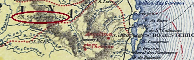
The Freguesia de N. Sra. da Conceição dos Coritibanos was founded in March 1864 and belonged to the Vila de Lages, 310 km west of the provincial capital Desterro (today Florianópolis). The name apparently comes from the forest landscape of the area, which used to be called Campo dos Coritibanos. The town was elevated to a vila in July 1869.
Reinhold Koester writes in Carimbologia XIV that there has been a post office there since July 1879, which is confirmed by the provincial president’s report from the following January:
Relatorio do Presidente da Provincia, 01/1880
The oldest postmark to date is CSC-0065a (fig. R. Koester, op. cit.):
CSC-0065a (RK) 1884
Koester also showed the cachet CSC-0065b:
CSC-0065b (RK)Carta da Republica dos Estados Unidos do Brazil, 1892
Andere Namen: Curitybanos
Die Freguesia de N. Sra. da Conceição dos Coritibanos wurde im März 1864 gegründet und gehörte zur Vila de Lages, 310 km westlich der Provinzhauptstadt Desterro (heute Florianópolis). Der Name stammt offenbar von der Waldlandschaft der Gegend, die früher Campo dos Coritibanos genannt wurde. Der Ort wurde im Juli 1869 zur Vila erhoben.
Reinhold Koester schreibt in Carimbologia XIV, dass es dort seit Juli 1879 ein Postamt gab, was durch den Bericht des Provinzpräsidenten vom folgenden Januar bestätigt wird:
Relatorio do Presidente da Provincia, 01/1880
Der bisher älteste Poststempel ist CSC-0065a (Abb. R. Koester, op. cit.):
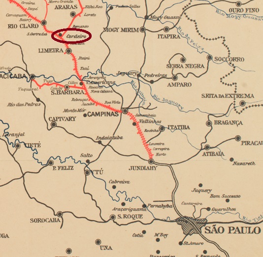
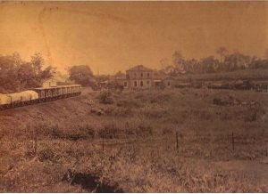
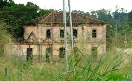
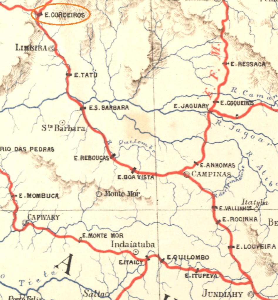
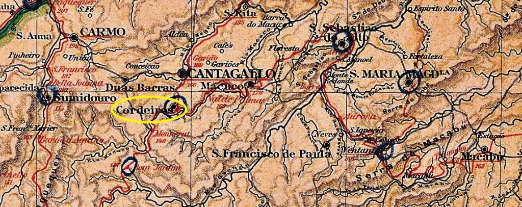
Cordeiros station in the province of São Paulo was opened in August 1876 by the railway company Cia. Paulista (main line) and was located on the west bank of the Ribeirão do Tatu in the Município de Limeira, 160 km north-west of the provincial capital. The line belonged to FEPASA from 1971 until its closure. Today, the tracks still exist, the station is being renovated and will house both a railway museum and the municipality’s cultural office.
In 1901 (Photo: Adolfo Pinto, on estacoesferroviarias.com.br)In 2008, before the restoration (Photo: Ralph M. Giesbrecht, on estacoesferroviarias.com.br)
The area around the railway station became the district of Cordeiro in August 1899 and was renamed Cordeirópolis in November 1944, becoming an independent município in December 1948.
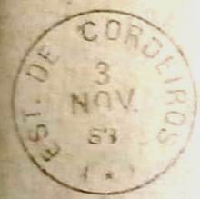
According to the regional press, there has been a post office at the railway station since December 1879:
Correio Paulistano, 27/12/1879
The oldest postmark is the French type CSP-0375a (coll. Fuad Ferreira Fo.):
CSP-0375a (FF) 1883
It was followed towards the end of the Empire by CSP-0375b (coll. Mário Celso Orsi Jr.):
CSP-0375b (MO) 1888-1890Estrada de Ferro Central do Brasil, 1890
Andere Namen: Cordeirópolis (1944)
Der Bahnhof Cordeiros in der Provinz São Paulo wurde im August 1876 von der Eisenbahngesellschaft Cia. Paulista (Hauptstrecke) eröffnet und lag am Westufer des Ribeirão do Tatu im Município de Limeira, 160 km nordwestlich der Provinzhauptstadt. Die Strecke gehörte von 1971 bis zu ihrer Stilllegung der FEPASA. Heute sind die Gleise noch vorhanden, der Bahnhof wird renoviert und soll sowohl ein Eisenbahnmuseum als auch das Kulturbüro der Gemeinde beherbergen.
1901 (Foto: Adolfo Pinto, auf estacoesferroviarias.com.br)2008, vor der Restaurierung (Foto: Ralph M. Giesbrecht, auf estacoesferroviarias.com.br)
Das Gebiet um den Bahnhof wurde im August 1899 zum Distrikt Cordeiro und im November 1944 in Cordeirópolis umbenannt, der seit Dezember 1948 ein eigenständiges Município ist.
Wie der regionalen Presse zu entnehmen ist, gab es am Bahnhof seit Dezember 1879 ein Postamt:
Correio Paulistano, 27.12.1879
Der älteste Poststempel ist der französische Typ CSP-0375a (Samml. Fuad Ferreira Fo.):
CSP-0375a (FF) 1883
Ihm folgte gegen Ende des Kaiserreichs CSP-0375b (Slg. Mário Celso Orsi Jr.):
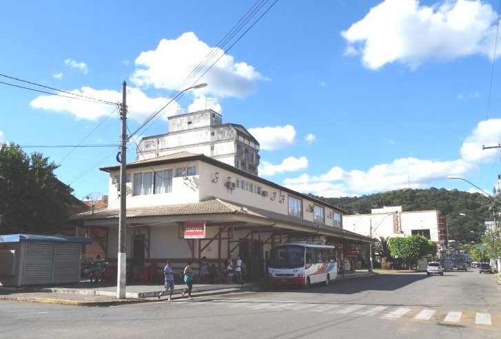
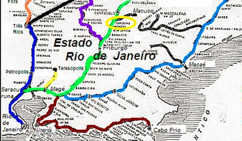
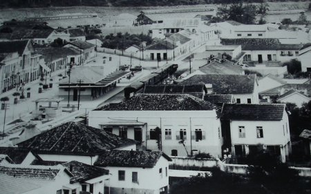
Cordeiros station (later called Cordeiro) was opened in October 1875 by the railway company E.F. do Cantagalo in the Município de Cantagalo, 190 km north-east of the capital Rio de Janeiro. The railway line was transferred to E.F. Leopoldina in 1887 and closed in 1967. Today, the tracks have disappeared and the station building serves as a bus station.
Around 1940 (Photo: Museu Municipal, apud estacoesferroviarias.com.br)March 2016 (Photo: Fernando Marietan, on estacoesferroviarias.com.br)
The area around the railway station was reclassified as Distrito de Cordeiro in September 1890, arose to município in March 1891 and then back to Distrito in May 1892, before being given the status of Município again in December 1943.
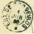
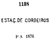
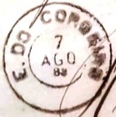
As can be seen from the list of imperial post offices (Tabella das Agencias do Correio do Imperio, Rio de Janeiro, 1885), there had been a post office at the railway station since 1877. The two oldest postmarks are so similar that some researchers believe they are the same postmark. Both CRJ-0395a and CRJ-0395b are also violet in colour, were used from the beginning and were given the numbers 1138 and 1281 respectively by P. Ayres (Catálogo de Carimbos Brasil-Império, S. Paulo, 1937, 1942):
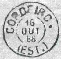
From the following postmark CRJ-0395c (coll. Klerman W. Lopes) the station was written CORDEIRO:
CRJ-0395c (KL) 1883-1884
This was followed by CRJ-0395d (fig. R. Koester, in Carimbologia XIV):
CRJ-0395d (RK) 1887-1890
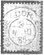
The following postmark CRJ-0395e (fig. R. Koester, op. cit.) has yet to be definitively confirmed, as it could also originate from the station of the same name in the province of São Paulo:
CRJ-0395e (RK) 1885
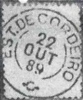
This doubt does not exist about CRJ-0395f (Fig. R. Koester):
CRJ-0395f (RK) 1889
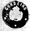
R. Koester also shows the cachet cancel CRJ-0395g:
CRJ-0395g (RK)Estrada de Ferro Leopoldina
Der Bahnhof Cordeiros (später Cordeiro genannt) wurde im Oktober 1875 von der Eisenbahngesellschaft E.F. do Cantagalo eröffnet und lag im Município de Cantagalo, 190 km nordöstlich der Hauptstadt Rio de Janeiro. Die Bahnlinie ging 1887 an die E.F. Leopoldina über und wurde 1967 stillgelegt. Heute sind die Gleise verschwunden, das Bahnhofsgebäude dient als Busbahnhof.
Um 1940 (Foto: Museu Municipal, apud estacoesferroviarias.com.br)Im März 2016 (Foto: Fernando Marietan, auf estacoesferroviarias.com.br)
Das Gebiet um den Bahnhof wurde im September 1890 zum Distrito de Cordeiro, im März 1891 zum Município und im Mai 1892 wieder zum Distrito zurückgestuft, bevor es im Dezember 1943 erneut den Status eines Município erhielt.
Wie aus dem Verzeichnis der kaiserlichen Postämter (Tabella das Agencias do Correio do Imperio, Rio de Janeiro, 1885) hervorgeht, gab es seit 1877 ein Postamt am Bahnhof. Die beiden ältesten Poststempel sind einander so ähnlich, dass manche Forscher meinen, es handele sich um denselben Poststempel. Beide, CRJ-0395a und CRJ-0395b, existieren ebenfalls in violett, wurden von Anfang an verwendet und erhielten von P. Ayres (Catálogo de Carimbos Brasil-Império, S. Paulo, 1937, 1942) die Nummern 1138 bzw. 1281:
Ab dem folgenden Stempel CRJ-0395c (Samml. Klerman W. Lopes) wurde der Bahnhof CORDEIRO geschrieben:
CRJ-0395c (KL) 1883-1884
Es folgte CRJ-0395d (Abb. R. Koester, in Carimbologia XIV):
CRJ-0395d (RK) 1887-1890
Der folgende Stempel CRJ-0395e (Abb. R. Koester, op. cit.) muss noch endgültig bestätigt werden, da er auch vom gleichnamigen Bahnhof in der Provinz São Paulo stammen könnte:
CRJ-0395e (RK) 1885
Dieser Zweifel besteht bei CRJ-0395f (Abb. R. Koester) nicht:
CRJ-0395f (RK) 1889
R. Koester zeigt auch den Siegelstempel CRJ-0395g:
Carta da Republca dos Estados Unidos do Brazil, 1892
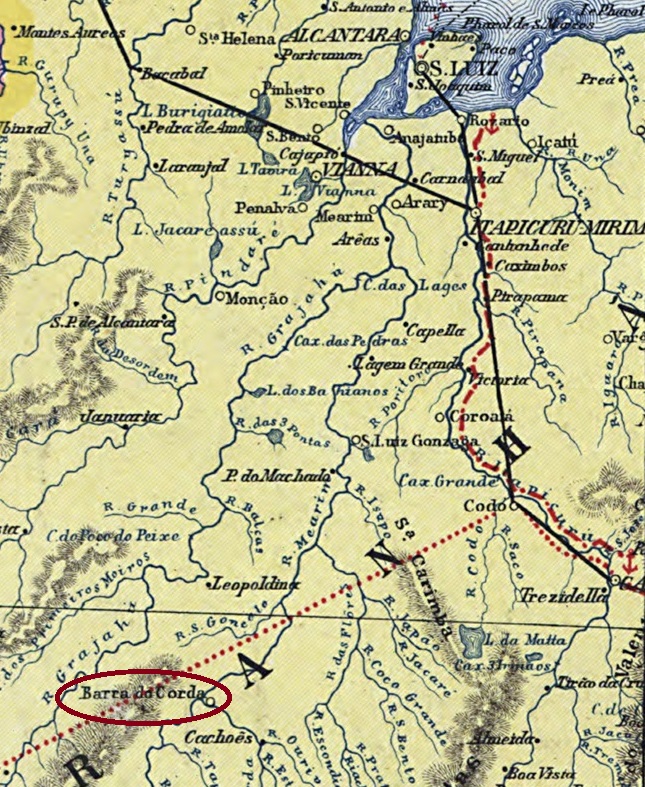
See also Barra do Corda (BMA-0035)
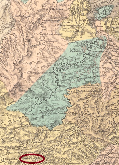
The chapel of Barra do Corda (or da Corda) was built in November 1849 at the mouth of the Corda River in the Mearim in the Município of Chapada, 450 km south of the provincial capital São Luís. The place rose to the status of vila in May 1854 and town in June 1894.
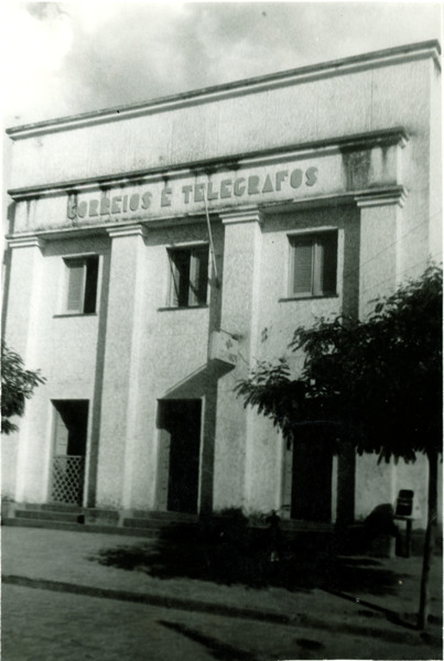
The post office, ca. 1975 (IBGE)
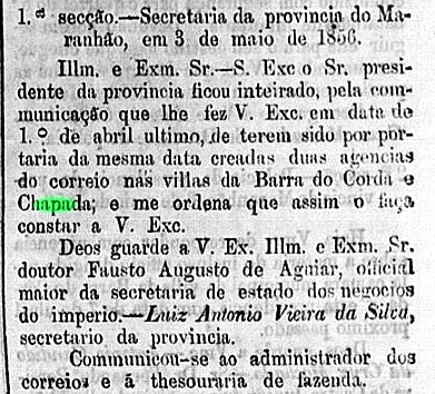
There had been a post office there since August 1856, as shown in the postal report (Relatorio Postal) for 1887. The regional official press gives April 1st of that year as the creation date:
Publicador Maranhense, 06/05/1856
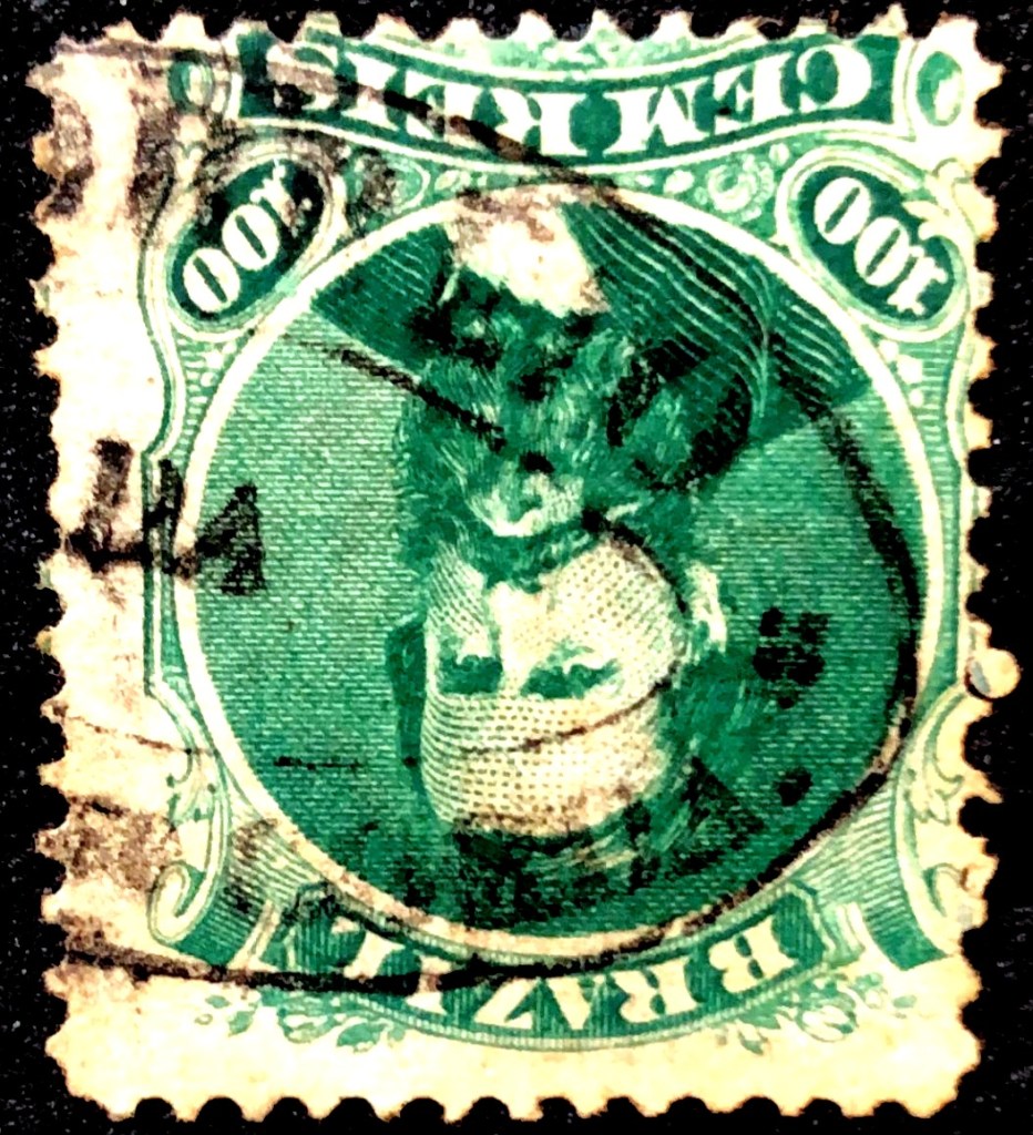
The oldest postmark BMA-0035a was found by philatelist Felipe Piccinini on a D. Pedro issue of 1866:
BMA-0035a (FP) 1866ff
BMA-0035c appeared much later (illustration from the Internet):
BMA-0035c (EB) 1891-1900ffAtlas do Imperio do Brasil, 1868
Siehe auch Barra do Corda (BMA-0035)
Die Kapelle von Barra do Corda (oder auch da Corda) wurde im November 1849 an der Mündung des Flusses Corda in den Mearim im Município von Chapada, 450 km südlich der Provinzhauptstadt São Luís. Der Ort stieg im Mai 1854 zur Vila und im Juni 1894 zur Stadt auf.
Das Postamt, ca. 1975 (IBGE)
Dort gab es ein Postamt seit August 1856, wie aus dem Postbericht (Relatorio Postal) für 1887 hervorgeht. Die regionale Amtspresse gibt dafür den 1. April d.J. an:
Publicador Maranhense, 06.05.1856
Der älteste Poststempel BMA-0035a wurde vom Philatelisten Felipe Piccinini auf einer D. Pedro-Ausgabe von 1866 gefunden:
BMA-0035a (FP) 1866ff
Viel später erschien BMA-0035c (Abb. aus dem Internet):