Categories
Carimbologia C-D

Cururupú, Maranhão (CMA-0115)

Atlas do Imperio do Brasil, 1868

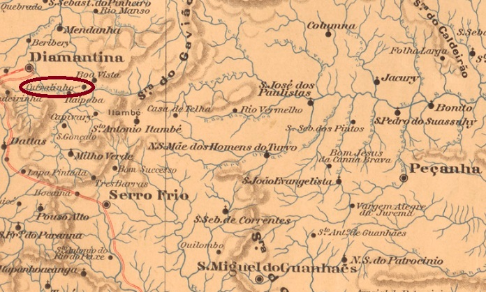
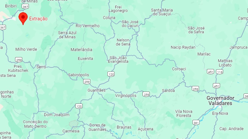
Other names: Cabelo de Velha

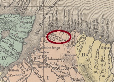
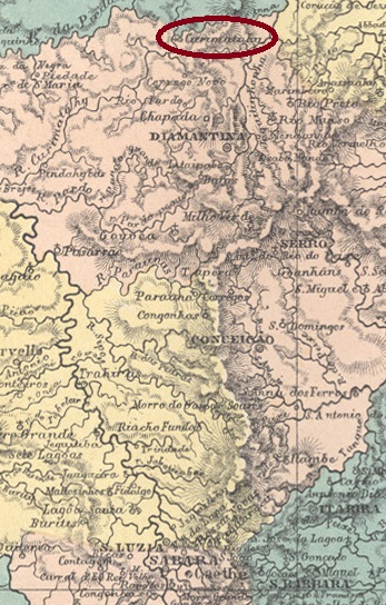
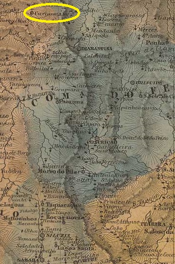
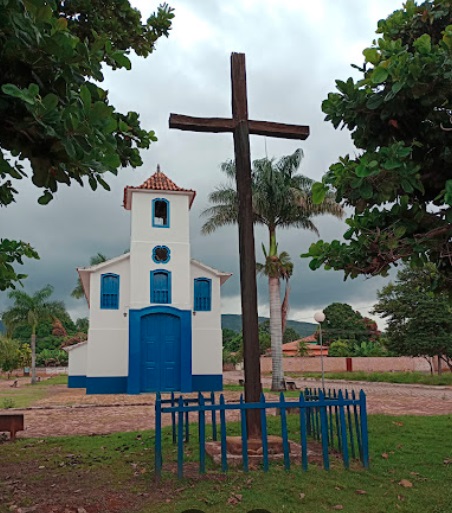
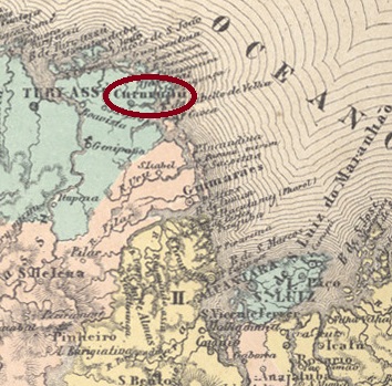
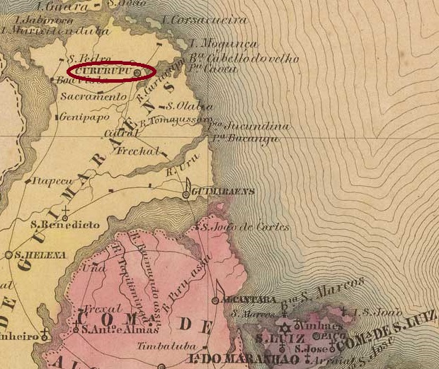
The Freguesia of S. João Baptista de Cururupu was founded in May 1835 in the Vila de Guimarães and was located on the north bank of the Cururupu, 160 kilometres northwest of the provincial capital of S. Luís do Maranhão. It became a vila in October 1841 and a town in March 1920. The name Cururupu means “Big Singing Frog” in the language of the Tupi Indians, and this is said to have been the name of the Tupinambá chief of the region, who was also called Cabelo de Velha (Old Woman’s Hair) …

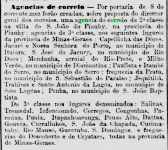
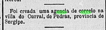
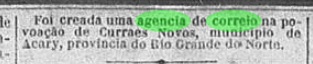
Here too, the post office was opened at least twice during the imperial era. The first was in June 1854, as R. Koester writes in Carimbologia XV and Aureo G. Santos confirms in Brasil Filatélico No.181 (Rio de Janeiro, 1977):

Aureo G. Santos (op. cit.)

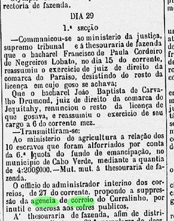
The agency was closed sometime after 1856, as it is still mentioned in the postal guide (Guia do Correio do Brasil) of 1856, and reopened in July 1858, as Nova Monteiro writes in Administrações e Agencias Postaes do Brasil Imperio (Brasil Filatelico/RJ, 1934-5; reprint SPP 1994-1999).

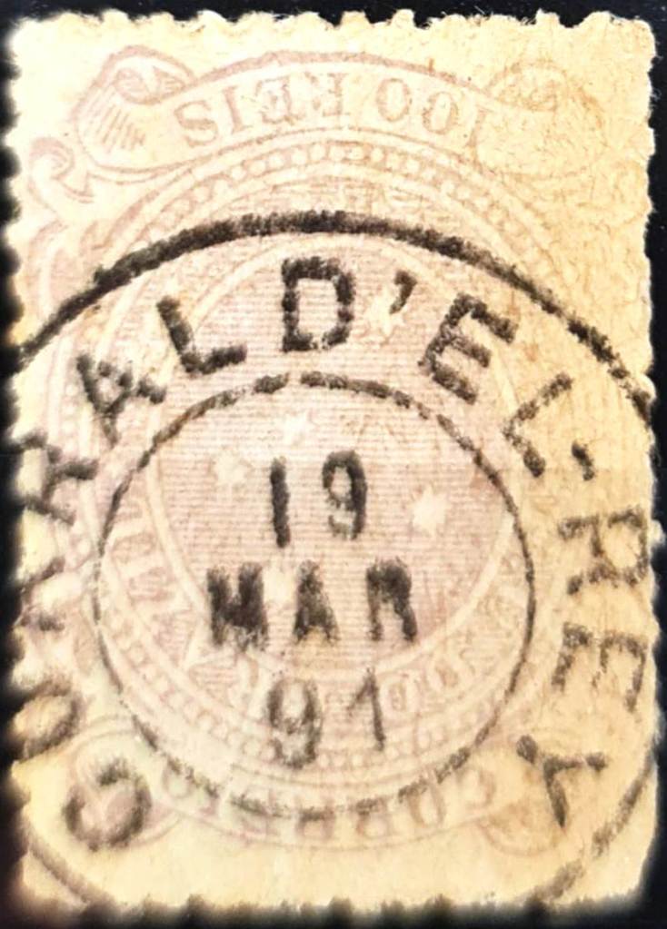
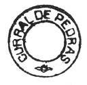
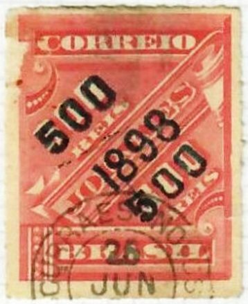
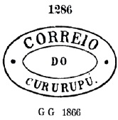
The oldest postmark to date is CMA-0115a, illustrated in P. Ayres’ Catálogo de Carimbos Brasil-Império (S. Paulo, 1937, 1942) with no. 1286:

CMA-0115a (P.A. 1286) 1866ff-1884ff

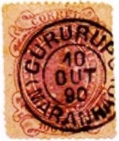
It was followed towards the end of the century by the double circle CMA-0115b (ill. Felipe Piccinini):

CMA-0115b (FP) 1890
Villiers de l’Ile Adam: Carta (…) da Provincia do Maranhão, 1850

Andere Namen: Cabelo de Velha

Die Freguesia des S. João Baptista de Cururupu wurde im Mai 1835 in der Vila de Guimarães gegründet und lag am Nordufer des Cururupu, 160 km nordwestlich der Provinzhauptstadt S. Luís do Maranhão. Im Oktober 1841 wurde es zur Vila und im März 1920 zur Stadt erhoben. Der Name Cururupu bedeutet in der Sprache der Tupi-Indianer „Großer Singender Frosch“, und so soll auch der Häuptling der Tupinambá der Region geheißen haben, der auch Cabelo de Velha (Altes Frauenhaar) genannt wurde…

Auch hier wurde das Postamt während der Kaiserzeit mindestens zweimal eröffnet. Das erste im Juni 1854, wie R. Koester in Carimbologia XV schreibt und Aureo G. Santos in Brasil Filatélico Nr. 181 (Rio de Janeiro, 1977) bestätigt:

Aureo G. Santos (op. cit.)

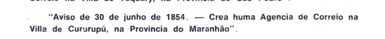
Die Agentur wurde irgendwann nach 1856 geschlossen, da sie noch im Postführer (Guia do Correio do Brasil) von 1856 erwähnt wird, und im Juli 1858 wieder eröffnet, wie Nova Monteiro in Administrações e Agencias Postaes do Brasil Imperio (Brasil Filatelico/RJ, 1934-5; Nachdruck SPP 1994-1999) schreibt.

Der bisher älteste Stempel ist CMA-0115a, abgebildet in P. Ayres’ Catálogo de Carimbos Brasil-Império (S. Paulo, 1937, 1942) mit Nr. 1286:

CMA-0115a (P.A. 1286) 1866ff-1884ff

Ihm folgte gegen Ende des Jahrhunderts der Doppelkreis CMA-0115b (Abb. Felipe Piccinini):

CMA-0115b (FP) 1890
Categories
Carimbologia C-D

Curuçá, Pará (CPA-0090)

Atlas do Imperio do Brasil, 1868

Other names: Vila Nova d’El-Rei

Vila Nova d’El-Rei was founded in 1757 from a former settlement of the Tupinambá Indians on the left bank of the Curuçá-Mirim, 140 kilometres north-east of the later provincial capital Belém do Pará. This was already extinguished in June 1758 and was only re-established in November 1850 under the name Curuçá. Curuçá was elevated to a town in May 1895, downgraded to a district of the Município de Marapanim in January 1931 and declared a Município again in December 1933.

Two periods of operation were found for the local post office. The first one must have started before June 1877, as the regional press reported on postal traffic to Curuçá at that time:

Jornal do Pará, 12/06/1877

This agency was still active in 1880, but must have been closed shortly afterwards, as a reopening in 1882 is noted in the directory of imperial post offices (Tabella das Agencias do Correio do Imperio, Rio de Janeiro, 1885). No imperial postmark has yet been found for Curuçá either.

Villiers de l’Ile Adam: Carta (…) das Provincias do Grão Pará e Alto Amazonas, 1850

Andere Namen: Vila Nova d’El-Rei

Aus einer ehemaligen Siedlung der Tupinambá-Indianer am linken Ufer des Curuçá-Mirim, 140 km nordöstlich der späteren Provinzhauptstadt Belém do Pará, entstand 1757 die Vila Nova d’El-Rei. Diese wurde bereits im Juni 1758 wieder gelöscht und erst im November 1850 unter dem Namen Curuçá neu gegründet. Curuçá wurde im Mai 1895 zur Stadt erhoben, im Januar 1931 zum Distrikt des Município de Marapanim herabgestuft und im Dezember 1933 wieder zum Município erklärt.

Für das örtliche Postamt wurden zwei Betriebszeiten festgestellt. Die erste Postamtseröffnung muss vor Juni 1877 stattgefunden haben, da die regionale Presse zu dieser Zeit über Postverkehr in Curuçá berichtete:

Jornal do Pará, 12.06.1877

Diese Agentur war 1880 noch aktiv, muss aber kurz danach geschlossen worden sein, da eine Wiedereröffnung im Jahr 1882 im Verzeichnis der kaiserlichen Postämter (Tabella das Agencias do Correio do Imperio, Rio de Janeiro, 1885) vermerkt ist. Auch von Curuçá wurde bisher kein kaiserlicher Poststempel gefunden.

Categories
Carimbologia C-D

Curralinho, Pará (CPA-0085)

Carta da Republica dos Estados Unidos do Brazil, 1892

The Freguesia de S. João Baptista de Curralinho was founded in November 1850 on the north bank of the Furo Sta. Maria and belonged to the Vila de Breves, 150 km (as the crow flies) or 350 km (boat distance) west of the provincial capital Belém do Pará. It became a Vila in March 1865 and a town in July 1895.

According to the regional press, there has been a post office there since May 1867:

Jornal do Pará, 06/06/1867

R. Koester shows the postmark CPA-0085b in Carimbologia XV, but without providing evidence that this belongs to the Curralinho of the province of Pará:

CPA-0085b (RK) 1886
Google Maps

Die Freguesia de S. João Baptista de Curralinho wurde im November 1850 am Nordufer des Furo (Wasserstraße) Sta. Maria gegründet und gehörte zur Vila de Breves, 150 km (Luftlinie) bzw. 350 km (Fahrstrecke) westlich der Provinzhauptstadt Belém do Pará. Es wurde im März 1865 zur Vila und im Juli 1895 zur Stadt erhoben.

Aus der regionalen Presse geht hervor, dass es dort seit Mai 1867 ein Postamt gab:

Jornal do Pará, 06.06.1867

R. Koester zeigt in Carimbologia XV den Poststempel CPA-0085b, ohne jedoch den Nachweis zu erbringen, dass es sich dabei um den Curralinho der Provinz Pará handelt:

CPA-0085b (RK) 1886
Categories
Carimbologia C-D

Curralinho, Minas Gerais (CMG-0940)

Estado de Minas Geraes, 1910

Other names: Extração

The village of Curralinho in the province of Minas Gerais was a settlement of the Vila de Diamantina on the north bank of the Ribeirão do Inferno (Hell’s Stream), 400 kilometres north of the provincial capital Ouro Preto. It was elevated to a freguesia in September 1862 and has been the district of Extração (extraction) since September 1923.

According to the Rio press, there has been a post office there since November 1881:

Jornal do Commercio/RJ, 12/11/1881

In História Postal de Minas Gerais (Belo Horizonte, 1997), Paula Sobrinho mentions a post office creation date of September 1901, but this is probably a reopening, since the agency should have been closed in mid-1886, according to the regional press:

A União, 28.09.1886

No imperial postmark from Curralinho in the province of Minas Gerais has yet been seen.

Google Maps

Andere Namen: Extração

Die Ortschaft Curralinho in der Provinz Minas Gerais war eine Siedlung der Vila de Diamantina am Nordufer des Ribeirão do Inferno (Höllenbach), 400 km nördlich der Provinzhauptstadt Ouro Preto. Sie wurde im September 1862 zur Freguesia erhoben und ist seit September 1923 der Distrikt Extração (Entnahme bzw Gewinnung).

Wie der Presse von Rio zu entnehmen ist, gab es dort seit November 1881 ein Postamt:

Jornal do Commercio/RJ, 12.11.1881

Paula Sobrinho nennt in História Postal de Minas Gerais (Belo Horizonte, 1997) ein Gründungsdatum im September 1901, es dürfte sich aber um eine Wiedereröffnung handeln, da die Agentur laut der regionalen Presse 1886 geschlossen werden sollte:

A União, 28.09.1886

. Bisher wurde kein kaiserlicher Poststempel aus Curralinho in der Provinz Minas Gerais gesehen.

Categories
Carimbologia C-D

Curralinho, Maranhão (CMA-0110)

Atlas do Imperio do Brasil, 1868

Other names: Coelho Neto (1934)

The Freguesia de Sant’Anna do Curralinho was founded in September 1861, belonged to the Vila do Brejo and was located on the west bank of the Parnaíba, 360 km south-east of the provincial capital São Luís do Maranhão. The village was later elevated to the status of Vila or Município at least four times: In June 1874, in May 1893, in April 1914 and in June 1931. In between, it was downgraded three times to the freguesia or district of Brejo or Buriti. Since December 1934, the município has been called Coelho Neto, a name that commemorates the writer (1864-1934) born in neighbouring Caxias.

Coelho Neto (Scott 974, MiNo. 1052, RHM C-507)

The local post office was opened in July 1889, as can be seen from the postal bulletin (Boletim Postal) of the following month:

Boletim Postal No. 4, August 1889

No imperial postmark from Curralinho in the province of Maranhão has yet been seen.

Carta da Republica dos Estados Unidos do Brazil, 1892

Andere Namen: Coelho Neto (1934)

Die Freguesia de Sant’Anna do Curralinho wurde im September 1861 gegründet, gehörte zur Vila do Brejo und lag am Westufer des Parnaíba, 360 km südöstlich der Provinzhauptstadt São Luís do Maranhão. Der Ort wurde später mindestens viermal zur Vila bzw. zum Município erhoben: Im Juni 1874, im Mai 1893, im April 1914 und im Juni 1931. Dazwischen wurde sie dreimal zur Freguesia bzw. zum Distrikt Brejo oder Buriti herabgestuft. Seit Dezember 1934 heißt der Município Coelho Neto, der Name erinnert an den im benachbarten Caxias geborenen Schriftsteller (1864-1934).

Coelho Neto (Scott 974, MiNr. 1052, RHM C-507)

Das örtliche Postamt wurde im Juli 1889 eröffnet, wie aus dem Postbulletin (Boletim Postal) des folgenden Monats hervorgeht:

Boletim Postal Nr. 4, August 1889

Bisher wurde noch kein kaiserlicher Poststempel aus Curralinho in der Provinz Maranhão gesehen.

Categories
Carimbologia C-D

Curralinho, Goiás (CGO-0055)

Villiers de l’Ile Adam: Carta (…) da Provincia de Goyaz, 1849

Other names: N. Sra. da Abadia, Itaberaí (1924)

The Freguesia de N. Sra. da Abadia do Curralinho was founded in December 1840 and belonged to the Vila de Goyaz (now Goiás Velho), 40 kilometres to the west. In November 1868 it became a Vila and in July 1903 it was elevated to the Municipio N. Sra. da Abadia. Since August 1924, the município has been called Itaberaí. The indigenous word means “river of glittering stones”.

There has been a post office there since August 1888, as can be seen from the Rio press:

Diario de Noticias/RJ, 29/08/1988

No imperial postmark has yet been seen from Curralinho in the province of Goiás.

Atlas do Imperio do Brasil, 1868

Andere Namen: N. Sra. da Abadia, Itaberaí (1924)

Die Freguesia de N. Sra. da Abadia do Curralinho wurde im Dezember 1840 gegründet und gehörte zu der 40 km westlich gelegenen Vila de Goyaz (heute Goiás Velho). Im November 1868 wurde sie zur Vila und im Juli 1903 zum Municipio N. Sra. da Abadia erhoben. Seit August 1924 trägt der Município den Namen Itaberaí. Das indigene Wort bedeutet „Fluss der glitzernden Steine“.

Ein Postamt gab es dort seit August 1888, wie aus der Presse von Rio hervorgeht:

Diario de Noticias/RJ, 29.08.1988

Bisher wurde kein kaiserlicher Poststempel aus Curralinho in der Provinz Goiás gesehen.

Categories
Carimbologia C-D

Curral d’El-Rey, Minas Gerais (CMG-0935)

Atlas do Imperio do Brasil, 1868

Other names: Cidade de Minas, Belo Horizonte (1890)

The Freguesia de N. Sra. da Boa Viagem do Curral d’El-Rey was founded in 1750, belonged to the Vila de Sabará and was located 100 kilometres north of the capital Vila Rica (later Ouro Preto). In April 1890, the locality of 8,000 inhabitants was renamed Distrito de Belo Horizonte. In December 1893, it was elevated to Município de Cidade de Minas, as the new capital of the state of Minas Gerais. The name obviously did not catch on, as the city was renamed Belo Horizonte again in July 1901, today a metropolis with over 2 million inhabitants.

As R. Koester (Carimbologia XVI) and Paula Sobrinho (História Postal de Minas Gerais, Belo Horizonte, 1997) write, there had been a post office there since July 1881 with the imperial postmark CMG-0935a (fig. Constantino Papazoglou):

CMG-0935a (CP) 1886-1891
Villiers de l’Ile Adam: Carta (…) da Provincia de Minas Geraes, 1849

Andere Namen: Cidade de Minas, Belo Horizonte (1890)

Die Freguesia de N. Sra. da Boa Viagem do Curral d’El-Rey wurde 1750 gegründet, gehörte zur Vila de Sabará und lag 100 km nördlich der Hauptstadt Vila Rica (später Ouro Preto). Im April 1890 wurde die 8.000 Einwohner zählende Stadt in Distrito de Belo Horizonte umbenannt. Im Dezember 1893 erfolgte die Erhebung zum Município de Cidade de Minas, als neue Hauptstadt des Bundesstaates Minas Gerais. Der Name hat sich offensichtlich nicht durchgesetzt, denn bereits im Juli 1901 wurde die Stadt wieder in Belo Horizonte umbenannt, heute eine Metropole mit über 2 Millionen Einwohnern.

Wie R. Koester (Carimbologia XVI) und Paula Sobrinho (História Postal de Minas Gerais, Belo Horizonte, 1997) schreiben, gab es dort seit Juli 1881 ein Postamt mit dem kaiserlichen Poststempel CMG-0935a (Abb. Constantino Papazoglou):

CMG-0935a (CP) 1886-1891
Categories
Carimbologia C-D

Curral de Pedras, Sergipe (CSE-0050)

Villiers de l’Ile Adam: Carta (…) das Provincias de Pernambuco, Alagoas e Sergipe, 1848

Other names: Curral das Pedras, Gararu (1877)

Curral de Pedras had been since May 1864 a freguesia of the Vila de Porto da Folha on the south bank of the São Francisco, 150 metres north of the provincial capital Aracaju. In April 1875 this freguesia changed to the Vila da Ilha do Ouro and in March 1877 it became the Vila de Senhor Bom Jesus dos Aflitos de Gararu.

Curral de Pedras post office, around 1960 (IBGE)

Two dates have been found for the creation of the local post office. Once in 1858, as Nova Monteiro writes in Administrações e Agencias Postaes do Brasil Imperio (Brasil Filatelico/RJ, 1934-5; reprint SPP 1994-1999). Then again in February 1884, as can be seen from the Rio press:

Gazeta de Notícias/RJ, 20/02/1884

The oldest postmark to date is CSE-0050b, shown to us by R. Koester in Carimbologia XV. However, Koester considers this postmark to be already republican:

CSE-0050b (RK)
Atlas do Imperio do Brasil, 1868

Andere Namen: Curral das Pedras, Gararu (1877)

Curral de Pedras war seit Mai 1864 eine Freguesia der Vila de Porto da Folha am Südufer des São Francisco, 150 m nördlich der Provinzhauptstadt Aracaju. Im April 1875 ging diese Freguesia zur Vila da Ilha do Ouro und wurde im März 1877 die Vila de Senhor Bom Jesus dos Aflitos de Gararu.

Postamt Curral de Pedras, um 1960 (IBGE)

Für die Gründung des örtlichen Postamtes wurden zwei Daten gefunden. Einmal 1858, wie Nova Monteiro in Administrações e Agencias Postaes do Brasil Imperio (Brasil Filatelico/RJ, 1934-5, Nachdruck SPP 1994-1999) schreibt. Dann wieder im Februar 1884, wie aus der Presse von Rio hervorgeht:

Gazeta de Notícias/RJ, 20.02.1884

Der bisher älteste Poststempel ist CSE-0050b, den uns R. Koester in Carimbologia XV gezeigt hat. Koester hält diesen Stempel jedoch für bereits republikanisch:

CSE-0050b (RK)
Categories
Carimbologia C-D

Curraes Novos, Rio Grande do Norte (CRN-0060)

Sociedade Geologica e Mineralogica, 1910

In 1754, a certain Cipriano L. Galvão owned a fazenda called Currais Novos, 180 kilometres west of the later provincial capital of Natal. In July 1788, a village had already been established there, which belonged to the Vila de Caicó. It was elevated to a freguesia in February 1884, when the settlement belonged to the Vila de N. Sra. da Guia de Acary. In October 1890, the Vila de Sant’Anna dos Curraes Novos was founded, which became a town in November 1920.

According to the Rio press, there had been a post office there since November 1887:

Cidade do Rio/RJ, 09/11/1887

The oldest postmark to date is CRN-0060a (image from the Internet)

CRN-0060a (EB) 1898ff
Atlas do Imperio do Brasil, 1868

1754 besaß ein gewisser Cipriano L. Galvão eine Fazenda namens Currais Novos, 180 km westlich der späteren Provinzhauptstadt Natal. Im Juli 1788 war dort bereits ein Dorf entstanden, das zur Vila de Caicó gehörte. Die Erhebung zur Freguesia erfolgte im Februar 1884, danach gehörte die Siedlung zur Vila de N. Sra. da Guia de Acary. Im Oktober 1890 wurde die Vila de Sant’Anna dos Curraes Novos gegründet, die im November 1920 zur Stadt erhoben wurde.

Wie aus der Presse von Rio hervorgeht, gab es dort seit November 1887 ein Postamt:

Cidade do Rio/RJ, 09.11.1887

Der bisher älteste Poststempel ist CRN-0060a (Bild aus dem Internet)

CRN-0060a (EB) 1898ff
Categories
Carimbologia C-D

Curimatahy, Minas Gerais (CMG-0930)

Atlas do Imperio do Brasil, 1868

Curimatahy (for the name see Corumbatahy, CSP-0385) was a parish of the Vila de Diamantina on the south bank of the Curimataí, 410 km north of the provincial capital Ouro Preto, from July 1832. In 1861 it became the Freguesia de N. Sra da Conceição do Curimatahy, and since December 1938 it has been a district of the Município de Buenópolis.

Google Maps (Photo: Flávio Almeida)

According to the Rio de Janeiro press, there has been a post office there since November 1881:

Jornal do Commercio/RJ, 12/11/1881

Paula Sobrinho writes in História Postal de Minas Gerais (Belo Horizonte, 1997) that the post office was closed in July 1939. No imperial postmark from Curimatahy in the province of Minas has yet been seen.

Villiers de l’Ile Adam: Carta (…) da Provincia de Minas Geraes, 1849

Curimatahy (zum Namen siehe Corumbatahy, CSP-0385) war seit Juli 1832 eine Pfarrei der Vila de Diamantina am Südufer des Curimataí, 410 km nördlich der Provinzhauptstadt Ouro Preto. 1861 wurde sie zur Freguesia de N. Sra da Conceição do Curimatahy, seit Dezember 1938 ist sie ein Distrikt des Município de Buenópolis.

Google Maps (Foto: Flávio Almeida)

Wie aus der Presse von Rio de Janeiro hervorgeht, gab es dort seit November 1881 ein Postamt:

Jornal do Commercio/RJ, 12.11.1881

Paula Sobrinho schreibt in História Postal de Minas Gerais (Belo Horizonte, 1997), dass das Postamt im Juli 1939 geschlossen wurde. Bisher wurde kein kaiserlicher Poststempel aus Curimatahy in der Provinz Minas gesehen.