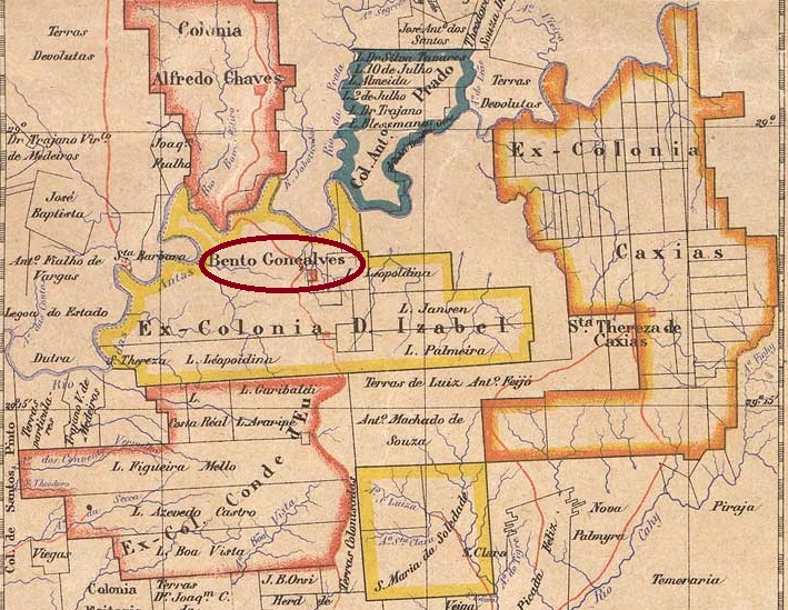
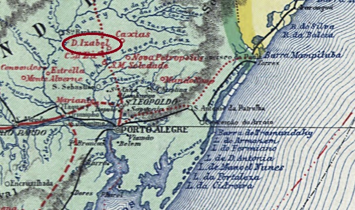
Other names: Colonia Izabel, Bento Gonçalves (1884)
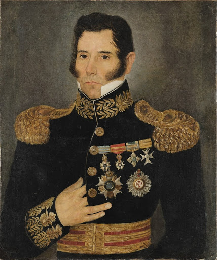
The colony was founded in 1870 around Vila de Triunfo, 120 kilometres north of the provincial capital Porto Alegre, but the first Italian settlers did not arrive until December 1875, when the place was placed under the control of Vila de S. João do Monte Negro. In April 1884 it was renamed Freguesia de Bento Gonçalves in honour of Farroupilha-Caudilho Bento Gonçalves da Silva (1788-1847), the first president of the secessionist República Riograndense, and in October 1890 it was finally elevated to Vila status.
Bento Gonçalves (Wikipedia)
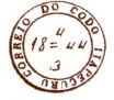
As can be seen from the list of imperial post offices (Tabella das Agencias do Correio do Imperio, Rio de Janeiro, 1885), there had been a post office there since 1881; the oldest postmark to date is DRS-0140a (fig. R. Koester, in Carimbologia XII).
DRS-0140a (RK) 1885-1890
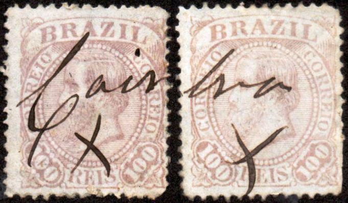
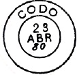
A mute postmark also dates from 1885 (fig. Corinphila Auctions):
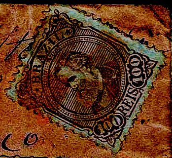
1885 (CO)Carta da Republica dos Estados Unidos do Brazil, 1892
Andere Namen: Colonia Izabel, Bento Gonçalves (1884)
Die Kolonie wurde 1870 auf dem Gebiet der Vila de Triunfo, 120 km nördlich der Provinzhauptstadt Porto Alegre, gegründet, doch die ersten italienischen Siedler kamen erst im Dezember 1875, als der Ort der Vila de S. João do Monte Negro unterstellt wurde. Im April 1884 erfolgte die Umbenennung in Freguesia de Bento Gonçalves zu Ehren von Farroupilha-Caudilhos Bento Gonçalves da Silva (1788-1847), dem ersten Präsidenten der abtrünnigen República Riograndense, und im Oktober 1890 schließlich die Erhebung zur Vila.
Bento Gonçalves (Wikipedia)
Wie aus dem Verzeichnis der kaiserlichen Postämter (Tabella das Agencias do Correio do Imperio, Rio de Janeiro, 1885) hervorgeht, gab es dort seit 1881 ein Postamt; der bisher älteste Poststempel ist DRS-0140a (Abb. R. Koester, in Carimbologia XII).
DRS-0140a (RK) 1885-1890
Aus dem Jahr 1885 stammt auch ein stummer Stempel (Abb. Corinphila Auktionen):
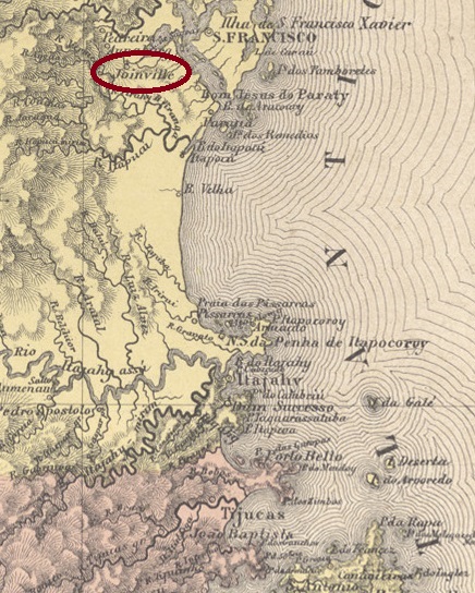
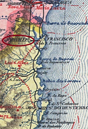
The original territory of the Propriedade de D. Francisca e Principe de Joinville was a gift from Emperor D. Pedro II to his sister Francisca and her fiancé, the Prince of Joinville, in May 1843. It was not until March 1851 that immigrants from Europe arrived in the colony of Dona Francisca, the centre of which became the settlement of Joinville in 1852. In April 1858, the village was elevated to the Freguesia de S. Francisco Xavier de Joinville, which belonged to the Vila de S. Francisco and was located on the west bank of the Cachoeira, 180 kilometres north of the provincial capital Desterro (today: Florianópolis). Joinville became a vila in March 1866 and a town in May 1877.
Three dates have been found for the creation of the local post office. The first in June 1857, as shown in the report of the Imperial Ministry for the following year:
Relatorio do Ministerio do Imperio/1858, p. 34
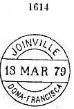
Then in May 1859, as R. Koester writes in Carimbologia XII. By 1863, however, the post office had already closed again, as it no longer appears in the list of post offices in the province of Santa Catarina. The third opening was decided in January 1867, this time under the place name Joinville, as can be seen from the directory of imperial post offices (Tabella das Agencias do Correio do Imperio, Rio de Janeiro, 1885).
The oldest postmark is the one with the imperial seal CSC-0055a (fig. R. Koester, op. cit.), as it was found on a colonist’s letter from 1858.
CSC-0055a (RK) 23 July 1858
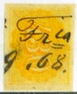
A handwritten obliteration dated 1868 was found by Felipe Piccinini, and probably comes from there.
1868 (FP)
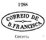
Then came DSC-0290a, known under no. 1288 by P. Ayres in Catálogo de Carimbos Brasil-Império (S. Paulo, 1937, 1942):
DSC-0290a (P.A. 1288) 1867-1873
It was followed by DSC-0085a, which also exists in blue and brown and is also illustrated in P. Ayres (op. cit.), this time with the no. 1614:
DSC-0085a(P.A. 1614) 1875-1885
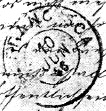
The postmark as double circle DSC-0290b (illustr. R. Koester) is puzzling, because around 1886 the place name Dona Francisca was no longer in use:
DSC-0290b (RK) 1886
Postmarks under Joinville will be listed under JSC-0145.
Carta da Republica dos Estados Unidos do Brazil, 1892
Text am 29.01.2024 aktualisiert
Andere Namen: Joinville
Das ursprüngliche Gebiet der Propriedade de D. Francisca e Principe de Joinville war eine Schenkung des Kaisers D. Pedro II. im Mai 1843 an seine Schwester Francisca und ihren Verlobten, den Prinzen von Joinville. Erst im März 1851 kamen Einwanderer aus Europa in die Kolonie Dona Francisca, deren Kern 1852 die Siedlung Joinville wurde. Im April 1858 wurde der Ort zur Freguesia de S. Francisco Xavier de Joinville erhoben, die zur Vila de S. Francisco gehörte und am Westufer des Cachoeira, 180 km nördlich der Provinzhauptstadt Desterro (heute: Florianópolis) lag. Joinville wurde im März 1866 zur Vila und im Mai 1877 zur Stadt erhoben.
Für die Gründung des örtlichen Postamtes wurden drei Daten gefunden. Die erste im Juni 1857, wie aus dem Bericht des kaiserlichen Ministeriums für das folgende Jahr hervorgeht:
Relatorio do Ministerio do Imperio/1858, S. 34
Dann im Mai 1859, wie R. Koester in Carimbologia XII schreibt. Um 1863 war das Postamt jedoch bereits wieder geschlossen, da es im Verzeichnis der Postämter der Provinz Santa Catarina nicht mehr auftaucht. Die dritte Eröffnung wurde im Januar 1867 beschlossen, diesmal unter dem Ortsnamen Joinville, wie aus dem Verzeichnis der kaiserlichen Postämter (Tabella das Agencias do Correio do Imperio, Rio de Janeiro, 1885) hervorgeht.
Der älteste Poststempel ist der mit dem kaiserlichen Siegel CSC-0055a (Abb. R. Koester, op. cit.), da er auf einem Kolonistenbrief aus dem Jahr 1858 gefunden wurde.
CSC-0055a (RK) 23.07.1858
Eine handschriftliche Entwertung von 1868 wurde von Felipe Piccinini gefunden und stammt wahrscheinlich von dort.
1868 (FP)
Danach kam DSC-0290a, bekannt unter der Nr. 1288 durch P. Ayres in Catálogo de Carimbos Brasil-Império (S. Paulo, 1937, 1942):
DSC-0290a (P.A. 1288) 1867-1873
Ihm folgte DSC-0085a, den es auch in blau und braun gibt und der auch bei P. Ayres (op. cit.) abgebildet ist, diesmal mit der Nr. 1614:
DSC-0085a (P.A. 1614) 1875-1885
Der Poststempel als Doppelkreis DSC-0290b (Abb. R. Koester) ist ein Rätsel, denn um 1886 war der Ortsname Dona Francisca längst nicht mehr gebräuchlich:
DSC-0290b (RK) 1886
Poststempel mit dem Ortsnamen Joinville werden unter JSC-0145 aufgeführt.
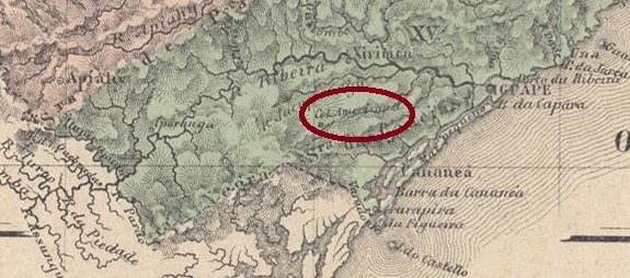
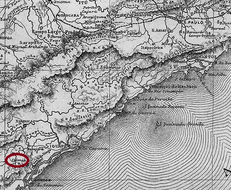
The fascinating history of this failed colonisation project is not yet fully documented. The Colonia de Cananea was founded by imperial decree in August 1861 and was intended to settle “Brazilians, Germans, English and Italians” on the east bank of the river Itapitangui behind the Vila de Cananea, 250 kilometres southwest of the provincial capital São Paulo. According to newspaper reports, however, it was mainly immigrants from Switzerland who settled there, but not for long: due to a lack of infrastructure (roads, schools, hospitals) and financial support, the colony languished and disappeared from the records around 1900. Today, the former colonial area is the rural suburb of Itapitangui in the Município Cananeia.
According to the directory of imperial post offices (Tabella das Agencias do Correio do Imperio, Rio de Janeiro, 1885), the local post office dates to 1869, but as there is no information on postal traffic in the following period, it can be assumed that the agency only started operating later. In October 1896, there were still 12 monthly postal connections between Cananea and Colonia de Cananea:
O Commercio de S. Paulo, 06/10/1896
No imperial postmark from Colonia de Cananea has yet been surely registered.
Provincia de São Paulo, 1879
Andere Namen: Itapitangui
Die faszinierende Geschichte dieses gescheiterten Kolonisierungsprojekts ist noch nicht vollständig dokumentiert. Die Colonia de Cananea wurde durch kaiserliches Dekret im August 1861 gegründet und sollte „Brasilianer, Deutsche, Engländer und Italiener“ am Ostufer des Flusses Itapitangui hinter der Vila de Cananea, 250 km südwestlich der Provinzhauptstadt São Paulo, ansiedeln. Laut Zeitungsberichten waren es jedoch vor allem Einwanderer aus der Schweiz, die sich dort niederließen, allerdings nicht lange: Mangels Infrastruktur (Straßen, Schulen, Krankenhäuser) und finanzieller Unterstützung dümpelte die Kolonie vor sich hin und verschwand um 1900 von den Landkarten. Heute ist das ehemalige Kolonialgebiet der ländliche Vorort Itapitangui im Município Cananeia.
Wie aus dem Verzeichnis der kaiserlichen Postämter (Tabella das Agencias do Correio do Imperio, Rio de Janeiro, 1885) hervorgeht, datiert das örtliche Postamt aus dem Jahr 1869. Da aber für die Folgezeit keine Informationen über Postverkehr vorliegen, ist davon auszugehen, dass die Agentur erst später ihren Betrieb aufnahm. Noch im Oktober 1896 gab es 12 monatliche Postverbindungen zwischen Cananea und Colonia de Cananea:
O Commercio de S. Paulo, 06.10.1896
Bisher wurde kein kaiserlicher Poststempel aus Colonia de Cananea mit Sicherheit identifiziert.
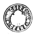
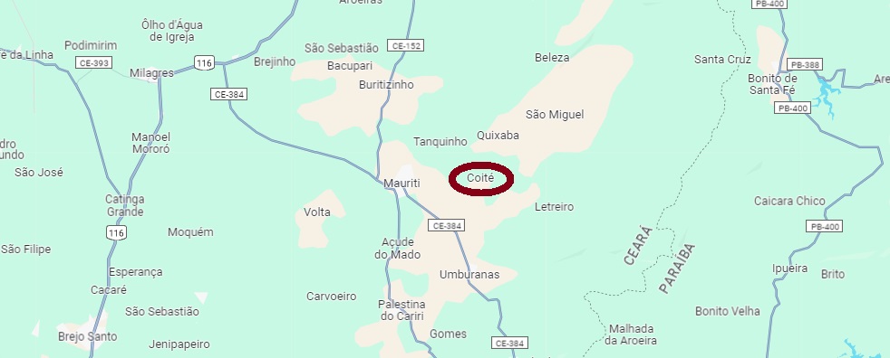
The Freguesia de S. Francisco de Paula de Coité, founded in December 1883, belonged to the Vila do Crato and was located on the east bank of the Riacho S. Miguel, 470 kilometres south of the provincial capital Fortaleza. In August 1890, Coité was elevated to a Vila, but in December 1933 it was downgraded to a district of the Município de Maurity. This has remained the case to this day.
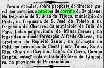
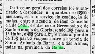
There has been a post office there since October 1882, as R. Koester (Carimbologia XI) writes. This is also confirmed by the press from Rio, although the place name is given incorrectly here.
O Globo/RJ, 28.10.1882
So far, only the cachet CCE-0110a (fig. R. Koester) has been found for the Empire.
CCE-0110a (RK)Google Maps
Die im Dezember 1883 gegründete Freguesia de S. Francisco de Paula de Coité gehörte zur Vila do Crato und lag am Ostufer des Riacho S. Miguel, 470 km südlich der Provinzhauptstadt Fortaleza. Im August 1890 wurde Coité zur Vila erhoben, aber im Dezember 1933 wurde es zum Distrikt des Município de Maurity herabgestuft. Dies ist bis heute so geblieben.
Ein Postamt gab es dort seit Oktober 1882, wie R. Koester (Carimbologia XI) schreibt. Das wird auch durch die Presse aus Rio bestätigt, wenngleich hier der Ortsname falsch angegeben ist.
O Globo/RJ, 28.10.1882
Bisher wurde nur der Siegelstempel CCE-0110a (Abb. R. Koester) für das Kaiserreich gefunden.
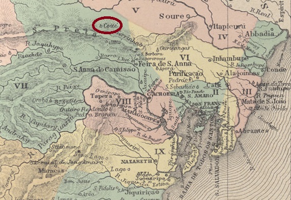
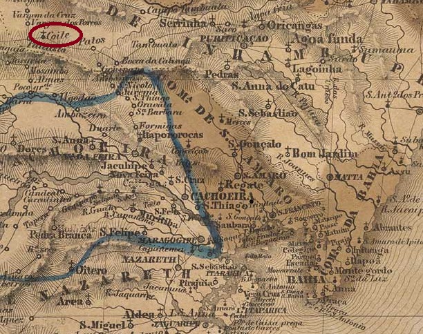
The Freguesia de N.Sra. da Conceição do Coité, which had existed since May 1855, belonged to the Vila de Riachão de Jacuipe and was located 220 kilometres northwest of the provincial capital Salvador da Bahia. In December 1890 it became the Vila de Conceição do Coité, but in June 1931 it was demoted to the district of Riachão de Jacuípe. Coité has been an independent município again since July 1933.
The local postal agency must have started operating as early as September 1888; at that time there was a regular postal service to Coité, as reported by the Rio press:
Gazeta de Noticias/RJ, 27/09/1888
No imperial postmark from Coité/BA has yet been seen.
Villiers de l’Ile Adam: Carta (…) da Provincia da Bahia, 1848
Andere Namen: Conceição de Coité (1890)
Die seit Mai 1855 bestehende Freguesia de N.Sra. da Conceição do Coité gehörte zur Vila de Riachão de Jacuipe und lag 220 km nordwestlich der Provinzhauptstadt Salvador da Bahia. Im Dezember 1890 wurde es zur Vila de Conceição do Coité, aber im Juni 1931 wurde es zum Distrikt von Riachão de Jacuípe degradiert. Seit Juli 1933 ist Coité wieder ein eigenständiges Município.
Die örtliche Postagentur muss bereits im September 1888 ihren Betrieb aufgenommen haben; damals gab es eine regelmäßige Postverbindung nach Coité, wie die Presse aus Rio berichtete:
Gazeta de Noticias/RJ, 27.09.1888
Bisher wurde kein kaiserlicher Poststempel aus Coité/BA gesehen.
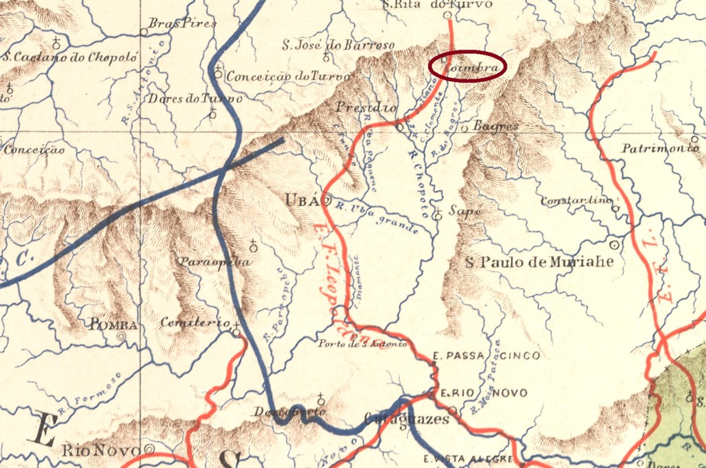
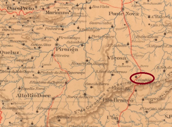
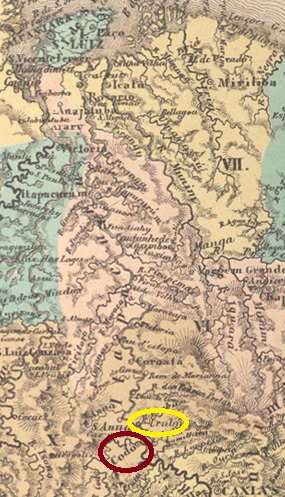
From October 1870, Coimbra was a curato of the Vila de Ubá, 120 kilometres south-east of the provincial capital Ouro Preto. In December 1873, the town was assigned to the Vila de Sta. Rita do Turvo (today: Viçosa) as the Freguesia de S. Sebastião do Coimbra. In September 1923, the district was renamed Coimbra, which has been an independent município since December 1948:
Both Paula Sobrinho (História Postal de Minas Gerais, Belo Horizonte, 1997) and R. Koester (Carimbologia XI) write that there was a post office there since August 1879. Here, too, the official postmark does not appear to have been delivered in time, as one initially cancelled by hand – also in red:
1879ff-1883ff (illustration from the Internet)
CMG-0770a (illustration by Claudio Coelho) was not added until around 1886. This cancel also appears in blue:
CMG-0770a (CC) 1886-1902Estado de Minas Geraes, 1910
Coimbra war ab Oktober 1870 ein Curato der Vila de Ubá, 120 km südöstlich der Provinzhauptstadt Ouro Preto gelegen. Im Dezember 1873 wurde der Ort als Freguesia de S. Sebastião do Coimbra der Vila de Sta. Rita do Turvo (heute: Viçosa) zugeordnet. Im September 1923 wurde der Distrikt in Coimbra umbenannt, das seit Dezember 1948 ein eigenständiger Município ist:
Sowohl Paula Sobrinho (História Postal de Minas Gerais, Belo Horizonte, 1997) als auch R. Koester (Carimbologia XI) schreiben, dass es dort seit August 1879 ein Postamt gab. Auch hier scheint der amtliche Poststempel nicht rechtzeitig geliefert worden zu sein, denn es wurde zunächst – ebenfalls in rot – von Hand entwertet:
1879ff-1883ff (Abbildung aus dem Internet)
Erst ab ca. 1886 kam CMG-0770a (Abb. Claudio Coelho) hinzu. Diesen Stempel gibt es auch in blau:
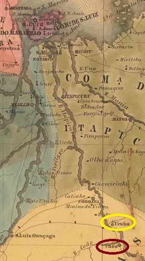
The history of the village began in April 1833, when it was founded as Vila de Urubu (Vulture) on the east bank of the Itapecuru, almost 300 kilometres south of the provincial capital S. Luís do Maranhão. In July 1838, the entire village was moved further south to the mouth of the Codó on the west bank of the Itapecuru and was henceforth called Vila de Santa Rita e Santa Philomena do Codó, which was elevated to the status of a town in April 1896.
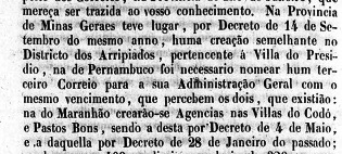
Nova Monteiro writes in Administrações e Agencias Postaes do Brasil Imperio (Brasil Filatelico/RJ, 1934-5; reprint SPP 1994-1999) that there had been a post office there since 28 January 1832. This date is probably a transcription error, as the place was still called Urubu at the time. In addition, a report from the Imperial Ministry gives a different date, exactly ten years later:
Relatorio do Ministerio do Imperio, 14/01/1843
To make matters worse, the postal report (Relatorio dos Correios) of 1886 gives 6 January 1842 for the founding of the agency in Codó, and here too R. Koester seems to have copied incorrectly, as he gives 6 July 1842 in Carimbologia XI.
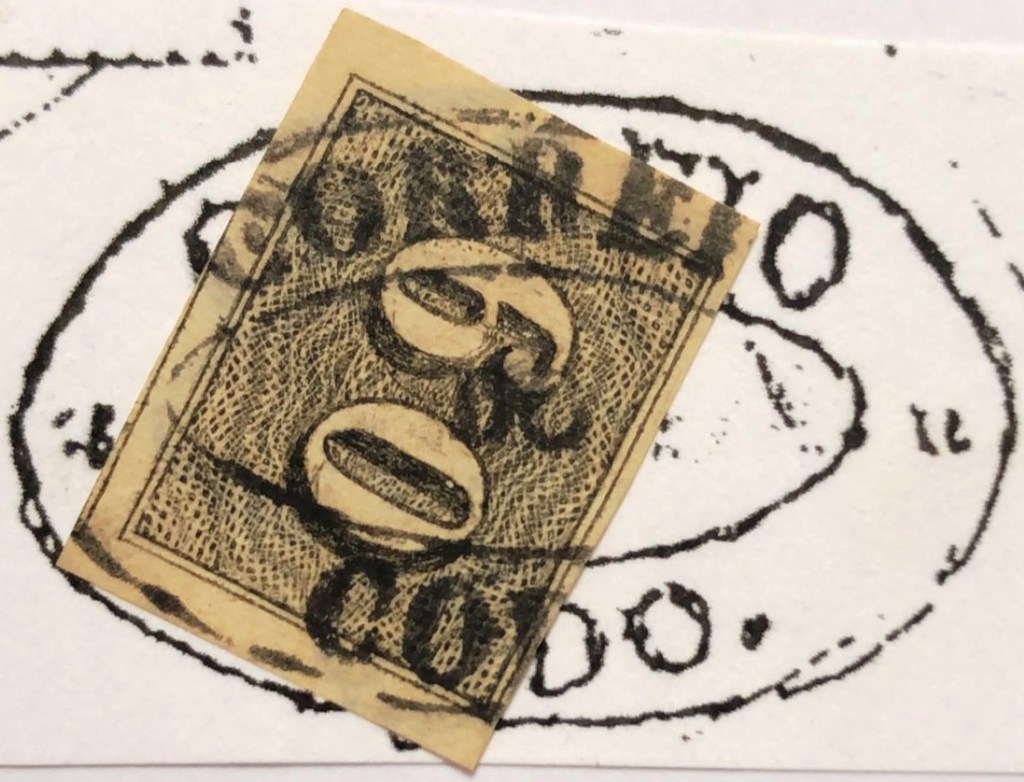
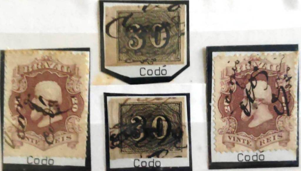
The oldest postmark of Codó could be the extremely rare CMA-0095a (fig. RHM catalogue):
CMA-0095a (RHM) 1843ff
CMA-0095b also appeared at about the same time, here inan illustration by Henrique B. Ferreira (Catálogo ilustrado dos carimbos sobre os olhos-de-boi, 4a. ed, Porto Alegre, 2017):
CMA-0095b (HBF) 1844
It was followed by CMA-0095c (fig. Roberto Assef Jr.) in a form typical for Maranhão:
CMA-0095c (RA) 1850ff-1878ff
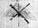
There may have been a shortage of postmarks in Codó around this time, as
stamps were also cancelled by hand:
1850ff-1866ff (fig. Antonio Eleftheriou)
From about 1878 the situation normalised with the arrival of CMA-0095d, illustrated here by P. Ayres (Catálogo de Carimbos Brasil-Império, S. Paulo, 1937, 1942):
CMA-0095d (P.A. p. 121) 1878-1900
Two mute cancels of the Empire also come from Codó. The first was given the no. 1346 by James Dingler and Klerman W. Lopes (Mute Cancellations of the Brazil Empire / Carimbos Mudos do Brasil Império, Brazil Philatelic Association, Rio de Janeiro, 2000):
BPA 1346
The second was shown to us by R. Koester (op. cit.):
1883 (RK)
Villiers de l’Ile Adam: CArta (…) da Provincia do Maranhão, 1850
Andere Namen: Urubu
Die Geschichte des Ortes begann im April 1833, als er als Vila de Urubu (Geier) am Ostufer des Itapecuru, knapp 300 km südlich der Provinzhauptstadt S. Luís do Maranhão, gegründet wurde. Im Juli 1838 wurde der gesamte Ort weiter südlich an die Mündung des Codó am Westufer des Itapecuru verlegt und hieß fortan Vila de Santa Rita e Santa Philomena do Codó, die im April 1896 zur Stadt erhoben wurde.
Nova Monteiro schreibt in Administrações e Agencias Postaes do BrasilImperio (Brasil Filatelico/RJ, 1934-5; Reprint SPP 1994-1999), dass es dort seit dem 28.01.1832 ein Postamt gab. Bei dieser Datumsangabe dürfte es sich um einen Abschreibfehler handeln, da der Ort damals noch Urubu hieß. Außerdem gibt ein Bericht des kaiserlichen Ministeriums ein anderes Datum an,das genau zehn Jahre später liegt:
Relatorio do Ministerio do Imperio, 14.01.1843
Erschwerend kommt hinzu, dass der Postbericht (Relatorio dos Correios) von 1886 für die Agenturgründung in Codó den 6.1.1842 angibt, und auch hier scheint R. Koester falsch abgeschrieben zu haben, denn er gibt dafür den 6.7.1842 in Carimbologia XI an. Der älteste Poststempel von Codó könnte der extrem seltene CMA-0095a (Abb. RHM-Katalog) sein:
CMA-0095a (RHM) 1843ff
Etwa zur gleichen Zeit erschien auch CMA-0095b, hier in einer Abbildung von Henrique B. Ferreira (Catálogo ilustrado dos carimbos sobre os olhos-de-boi, 4a. ed, Porto Alegre, 2017):
CMA-0095b (HBF) 1844
Ihm folgte CMA-0095c (Abb.Roberto Assef Jr.) in einer für Maranhão typischen Form:
CMA-0095c (RA) 1850ff-1878ff
Um diese Zeit könnte es in Codó einen Mangel an Poststempeln gegeben haben, denn es wurde auch von Hand gestempelt:
1850ff-1866ff (Abb. Antonio Eleftheriou)
Ab etwa 1878 normalisierte sich die Situation mit der Ankunft von CMA-0095d, hier abgebildet bei P. Ayres (Catálogo de Carimbos Brasil-Império, S. Paulo, 1937, 1942):
CMA-0095d (P.A. S. 121) 1878-1900
Aus Codó stammen auch zwei stumme Stempel des Kaiserreichs. Der
erste wurde von James Dingler und Klerman W. Lopes (Mute Cancellations of the Brazil Empire / Carimbos Mudos do Brasil Império, Brazil Philatelic Association, Rio de Janeiro, 2000) mit der Nr. 1346 versehen:
BPA 1346
Die zweite wurde uns von R.Koester (op. cit.) gezeigt:
Carta da Republica dos Estados Unidos do Brazil, 1892
Text update of January 23, 2024
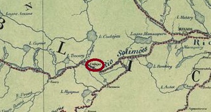
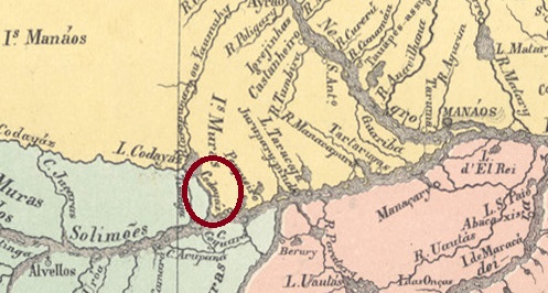
The Freguesia de N. Sra. da Graça de Codajaz was founded in June 1868 on the north bank of the Amazon River, 315 kilometres west of the Vila de Manaus. In May 1874 it was elevated to Vila, but lost this status in November 1930 and became a district of Coary. In September 1931 it was again elevated to município, and since March 1938 Codajás (as it is now spelt) has been a town.
As R. Koester writes in Carimbologia XI, there has been a post office there since 1884. The only postmark from the 19th century so far is CAM-0035a (image from the Internet), which was also found in carmine:
CAM-0035a (EB) 1890ff-1893ffAtlas do Imperio do Brasil, 1868
Die Freguesia de N. Sra. da Graça de Codajaz wurde im Juni 1868 gegründet und liegt am Nordufer des Amazonas, 315 km westlich der Vila de Manaus. Im Mai 1874 wurde sie zur Vila erhoben, verlor diesen Status jedoch im November 1930 und wurde ein Distrikt von Coary. Im September 1931 wurde es wieder zum Município erhoben, und seit März 1938 ist Codajás (wie es heute geschrieben wird) eine Stadt.
Wie R. Koester in Carimbologia XI schreibt, gab es dort seit 1884 ein Postamt. Der bisher einzige Poststempel aus dem 19. Jahrhundert ist CAM-0035a (Abbildung aus dem Internet), der auch in Karmin gefunden wurde:
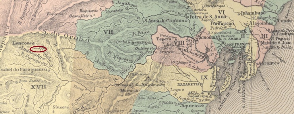
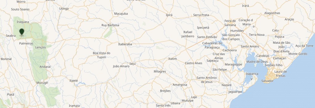
Sto. Antonio do Cochó do Malheiro was an arraial of the Chapada Diamantina at the beginning of the 19th century, which belonged to the Freguesia de Palmeiras in the Vila de Lençóis and was located on the north bank of the Cochó, 460 kilometres west of the later provincial capital Salvador da Bahia. The area was very quickly colonised after the discovery of gold and diamond deposits and apparently also attracted criminals. From May 1889, Cochó do Malheiro belonged to the newly founded Villa Agricola do Campestre. When hardly any precious stones were found, the town fell into disrepair very quickly and was so badly destroyed by gang wars in 1895 that it has remained a ghost town to this day. Part of the Município Seabra since June 1931, it has been a protected monument since 2002.
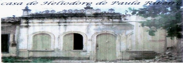
Manor house (Photo: Yvana Paraguassu in ogazzeta.blogspot.com)
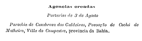
The local post office was opened in August 1889, as can be seen from the postal bulletin (Boletim Postal) of the following month:
Boletim Postal No. 5, Sept.1889
No imperial postmark of Cochó do Malheiro has yet been seen. It must be very rare, if at all.
Goolge Maps
Andere Namen: Cochó de Malheiros
Sto. Antonio do Cochó do Malheiro war zu Beginn des 19. Jahrhunderts ein Arraial der Chapada Diamantina, die zur Freguesia de Palmeiras in der Vila de Lençóis gehörte und am Nordufer des Cochó, 460 km westlich der späteren Provinzhauptstadt Salvador da Bahia, lag. Das Gebiet wurde nach der Entdeckung von Gold- und Diamantenvorkommen sehr schnell besiedelt und zog offenbar auch Kriminelle an. Ab Mai 1889 gehörte Cochó do Malheiro zur neu gegründeten Villa Agricola do Campestre. Als kaum noch Edelsteine gefunden wurden, verfiel der Ort sehr schnell und wurde 1895 durch Bandenkriege so stark zerstört, dass er bis heute eine Geisterstadt geblieben ist. Seit Juni 1931 Teil des Município Seabra, seit 2002 unter Denkmalschutz.
Herrenhaus (Foto: Yvana Paraguassu in ogazzeta.blogspot.com)
Das örtliche Postamt wurde im August 1889 eröffnet, wie aus dem Postbulletin (Boletim Postal) des Folgemonats hervorgeht:
Boletim Postal Nr. 5, Sept.1889
Bisher wurde noch kein kaiserlicher Poststempel von Cochó do Malheiro gesehen. Er muss, wenn überhaupt, sehr selten sein.
Other names: Macacos, Morro Grande, Barão de Cocais (1943)
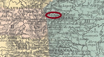
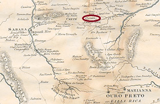
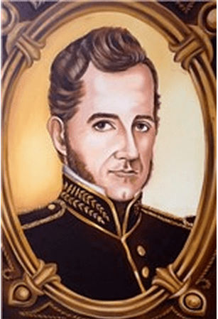
In January 1752, the village is said to have been called Arraial de Macacos (Monkey Village), which belonged to the Freguesia de S. João de Morro Grande and was located on the Rio Santa Barbara, 80 kilometres north of the later provincial capital of Ouro Preto. The name Cocaes (coconut grove) is said to come from a mine in the area. In May 1856, the Freguesia de Sant’Anna de Cocaes was created in the Vila de Sta. Barbara, which has been Município de Barão de Cocais since December 1943. The noble name commemorates José Feliciano Pinto Coelho da Cunha (1792-1869), landowner, military man, politician, entrepreneur and governor of the province of Minas Gerais, who was born here and died as a baron.
Barão de Cocaes
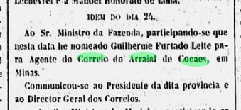
For the local post office, Nova Monteiro in Administrações e Agencias Postaes do Brasil Imperio (Brasil Filatelico/RJ, 1934-5; reprint SPP 1994-1999) gives the date of foundation as January 1848, when a postal agent was appointed:
Gazeta Official/RJ, 27.01.1848
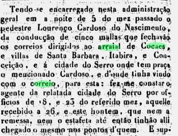
However, this date is in the middle of the second period of operation of the Cocaes post office. It has not yet been possible to determine when the first period of operation began, but it is known that there was regular postal traffic to Cocaes as early as October 1840:
O Universal, 09.11.1840
The first period of operation ended around 1843, as can be seen from the report of the Ministry of the Empire for the following year:
Relatorio do Ministerio do Imperio, 1844
However, the Cocaes post office was soon reopened, as can be seen from the 1845 report:
Relatorio do Ministerio do Imperio, 1845
The second period of operation ended around 1851, as is also officially reported:
Relatorio do Ministerio do Imperio, 1852
It was not until ten years later, in October 1862, that the third post office was opened in Cocaes, as R. Koester writes in Carimbologia XI and as the directory of imperial post offices (Tabella das Agencias do Correio do Imperio, Rio de Janeiro, 1885) confirms.
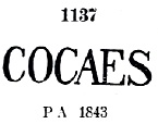
The oldest postmark there to date is CMG-0760a, known through Paulo Ayres (Catálogo de Carimbos Brasil-Império, S. Paulo, 1937, 1942) with no. 1137 from ca. 1843 on, but since it was assigned a pre-philatelic number in the RHM catalogue, it can be assumed that the postmark was also used in the first period of operation.
CMG-0760a (P.A. 1137, RHM P-MG-20) 1843ff-1866ff
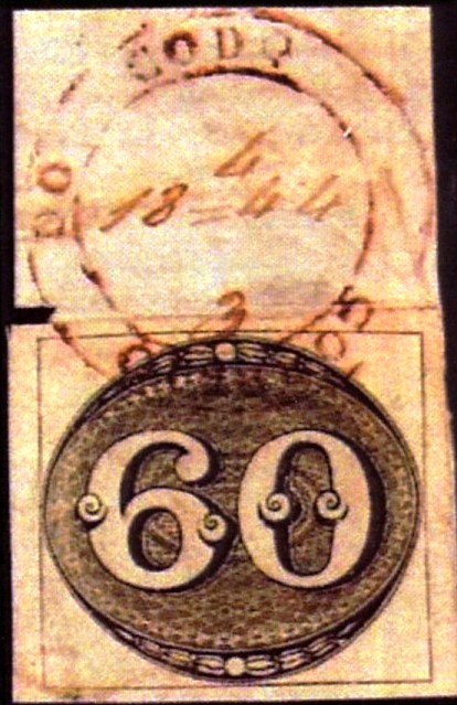
At the beginning of the third operating period, the old postmark must have become obsolete, as cancellations were made by hand from around 1866:
1866ff-1875 (EB/FF)
The successor postmark CMG-0760b, which is also illustrated in P. Ayres (op. cit.), was not used until around 1881:
CMG-0760b (P.A. p. 121) 1881-1885
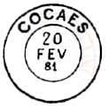
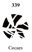
We also know a mute cancellation from Cocaes, which is illustrated both by P. Ayres (no. 29) and by James Dingler and Klerman W. Lopes (Mute Cancellations of the Brazil Empire / Carimbos Mudos do Brasil Império, Brazil Philatelic Association, Rio de Janeiro, 2000), here with no. 339:
BPA 339 (P.A. 29) 1866ff-1882Mining Districts of Minas Geraes, 1835
Andere Namen: Macacos, Morro Grande, Barão de Cocais (1943)
Im Januar 1752 soll der Ort noch Arraial de Macacos (Affendorf) geheißen haben, das zur Freguesia de S. João de Morro Grande gehörte und am Rio Santa Barbara, 80 km nördlich der späteren Provinzhauptstadt Ouro Preto lag. Der Name Cocaes (Kokoshain) soll von einer Mine in der Gegend stammen. Im Mai 1856 erfolgte die Erhebung zur Freguesia de Sant’Anna de Cocaes in der Vila de Sta. Barbara, die seit Dezember 1943 Município de Barão de Cocais ist. Der Adelsname erinnert an José Feliciano Pinto Coelho da Cunha (1792-1869), Großgrundbesitzer, Militär, Politiker, Unternehmer und Gouverneur der Provinz Minas Gerais, der hier geboren wurde und als Baron starb.
Barão de Cocaes
Für das örtliche Postamt gibt Nova Monteiro in Administrações e Agencias Postaes do Brasil Imperio (Brasil Filatelico/RJ, 1934-5; Reprint SPP 1994-1999) als Gründungsdatum den Januar 1848 an, als ein Postagent ernannt wurde:
Gazeta Official/RJ, 27.01.1848
Dieses Datum liegt jedoch in der Mitte der zweiten Betriebsperiode des Postamts Cocaes. Wann die erste Betriebsperiode begann, konnte bisher nicht festgestellt werden, aber es ist bekannt, dass es bereits im Oktober 1840 einen regelmäßigen Postverkehr nach Cocaes gab:
O Universal, 09.11.1840
Die erste Betriebsperiode endete um 1843, wie aus dem Bericht des Reichsministeriums für das folgende Jahr hervorgeht:
Relatorio do Ministerio do Imperio, 1844
Das Postamt von Cocaes wurde jedoch bald wieder eröffnet, wie aus dem Bericht von 1845 hervorgeht:
Relatorio do Ministerio do Imperio, 1845
Die zweite Betriebsperiode endete um 1851, wie ebenfalls offiziell berichtet wird:
Relatorio do Ministerio do Imperio, 1852
Erst zehn Jahre später, im Oktober 1862, fand die dritte Postamteröffnung in Cocaes statt, wie R. Koester in Carimbologia XI schreibt und wie das Verzeichnis der kaiserlichen Postämter (Tabella das Agencias do Correio do Imperio, Rio de Janeiro, 1885) bestätigt.
Der bisher älteste Stempel dort ist CMG-0760a, bekannt durch Paulo Ayres (Catálogo de Carimbos Brasil-Império, S. Paulo, 1937, 1942) mit Nr. 1137 ab ca. 1843. Da ihm jedoch im RHM-Katalog eine Prephila-Nummer zugeordnet wurde, ist davon auszugehen, dass der Stempel auch in der ersten Betriebsperiode verwendet wurde.
CMG-0760a (P.A. 1137, RHM P-MG-20) 1843ff-1866ff
Zu Beginn der dritten Betriebsperiode muss der alte Poststempel ausgedient haben, da ab ca. 1866 die Entwertung von Hand erfolgte:
1866ff-1875 (EB/FF)
Erst ab etwa 1881 wurde der Nachfolgestempel CMG-0760b verwendet, der auch bei P. Ayres (op. cit.) abgebildet ist:
CMG-0760b (P.A. S. 121) 1881-1885
Wir kennen auch einen stummen Stempel aus Cocaes, der sowohl bei P. Ayres (Nr. 29) als auch bei James Dingler und Klerman W. Lopes (Mute Cancellations of the Brazil Empire / Carimbos Mudos do Brasil Império, Brazil Philatelic Association, Rio de Janeiro, 2000) abgebildet ist, hier mit Nr. 339: