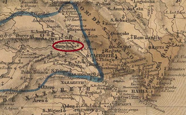
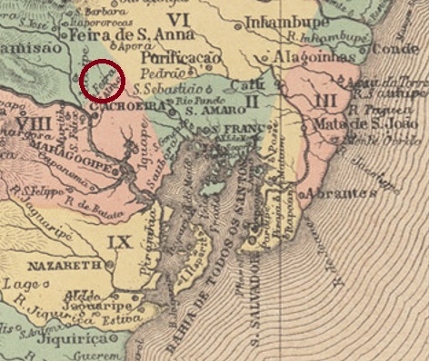
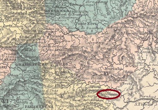
Villiers de l’Ile Adam: Carta (…) da Provincia da Bahia, 1848
Other names: Feira da Conceição, Nova Feira
The Freguesia de Nossa Senhora da Conceição was founded in May 1847, belonged to the Vila de Cachoeira and was located on the north bank of the Paraguaçu, 120 kilometres northwest of the provincial capital Salvador da Bahia. The village was elevated to an independent vila or municipio three times: in July 1926, in September 1931 and most recently in June 1944, whereby Conceição da Feira was even a town between March 1938 and December 1943; it was then downgraded – for the second time after June 1931 – to the district of Cachoeira.
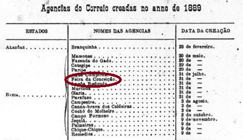
The local post office was established in July 1889, as R. Koester writes in Carimbologia XIII. The postal report of that year confirms this, albeit with the place name Feira da Conceição:
Relatorio Postal 1889
No imperial postmark from this place was previously known.
Atlas do Imperio do Brasil, 1868
Andere Namen: Feira da Conceição, Nova Feira
Die Freguesia de Nossa Senhora da Conceição wurde im Mai 1847 gegründet, gehörte zur Vila de Cachoeira und lag am Nordufer des Paraguaçu, 120 km nordwestlich der Provinzhauptstadt Salvador da Bahia. Der Ort wurde dreimal zur eigenständigen Vila bzw. Municipio erhoben: im Juli 1926, im September 1931 und zuletzt im Juni 1944, wobei Conceição da Feira zwischen März 1938 und Dezember 1943 sogar Stadt war; danach wurde der Ort – zum zweiten Mal nach Juni 1931 – zum Distrikt von Cachoeira herabgestuft.
Das örtliche Postamt entstand im Juli 1889, wie R. Koester in Carimbologia XIII schreibt. Der damalige Postbericht (Relatorio Postal) bestätigt dies, allerdings mit dem Ortsnamen Feira da Conceição:
Relatorio Postal 1889
Bisher war kein kaiserlicher Poststempel aus diesem Ort bekannt.
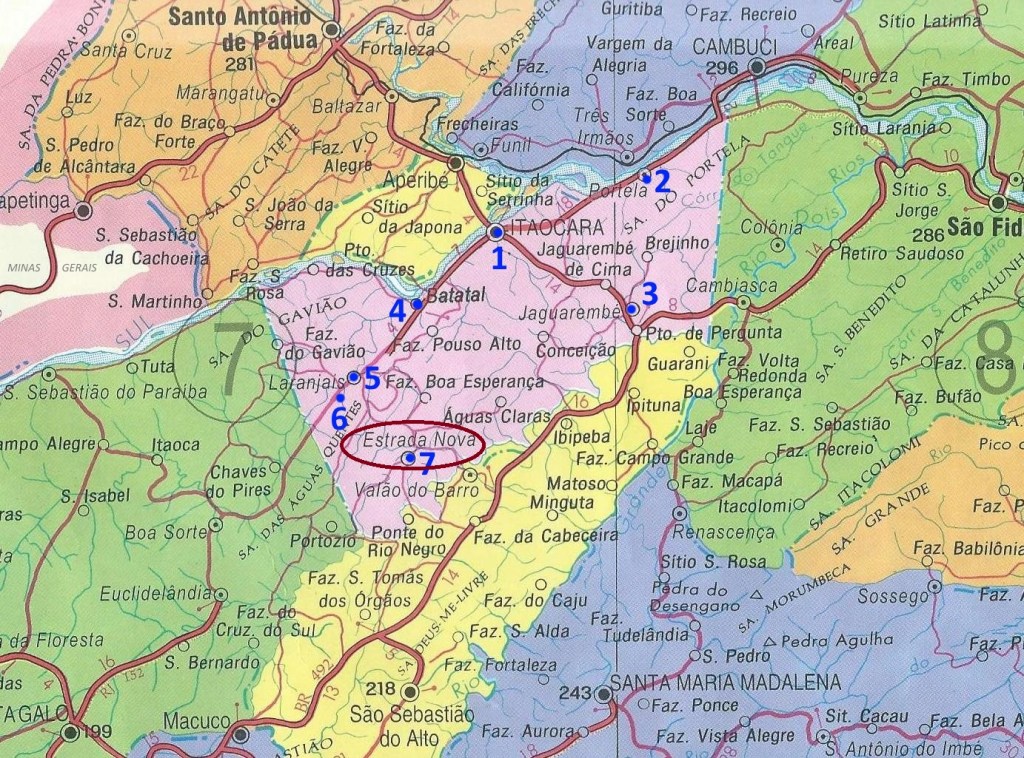
Other names: Arraial do Tatu, Itapexirica, Estrada Nova.
See also Arraial da Conceição (ARJ-0065)
This settlement was originally called Arraial do Tatu or Itapexirica and was located near Cantagallo, 240 km northeast of the capital Rio de Janeiro. In 1859 it was renamed N. Sa. da Conceição da Estrada Nova, and in September 1890 it became a district, changing to the newly created Município of Itaocara the following month. Finally, in November 1924, the district was given the simplified name of Estrada Nova.
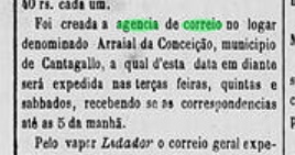
The local post office was established in December 1873, as reported by the regional press:
A Reforma, 06.12.1873
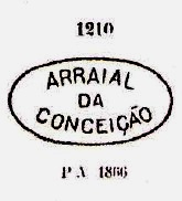
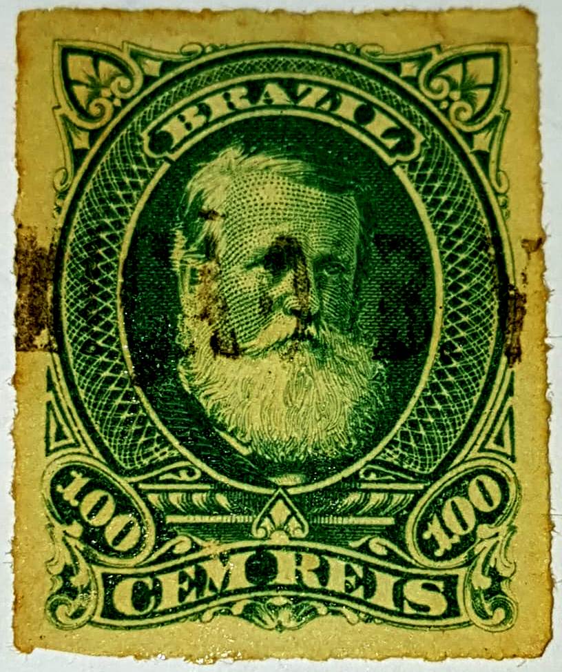
The first postmark is ARJ-0065a, which also exists in brown, blue, green and dark purple. It was in use until about 1879 and is already known by Paulo Ayres (Catálogo de Carimbos Brasil-Império, S. Paulo, 1937, 1942) under No. 1210:
ARJ-0065a (P.A. 1210, MPT 351)
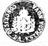
Further postmarks (from around 1881) bear the place name (Conceição da) Estrada Nova and have already been presented by R. Koester in Carimbologia XIII. Here we have the postmark CRJ-0355a:
CRJ-0355a (RK)
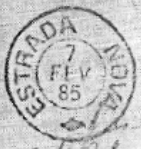
Towards the end of the imperial period came the double circle ERJ-0525a:
ERJ-0525a (RK) 1881-1890agenciaspostais.com.br
Andere Namen: Arraial do Tatu, Itapexirica, Estrada Nova
Siehe auch Arraial da Conceição (ARJ-0065)
Diese Siedlung hieß ursprünglich Arraial do Tatu bzw. Itapexirica und lag bei Cantagallo, 240 km nordöstlich der Hauptstadt Rio de Janeiro entfernt. 1859 erfolgte eine Umbenennung zu N. Sa. da Conceição da Estrada Nova, und im September 1890 wurde daraus ein Distrikt, der im darauffolgenden Monat zum neu gegründeten Município von Itaocara wechselte. Schließlich erhielt der Distrikt im November 1924 den verinfachten Namen Estrada Nova.
Das örtliche Postamt wurde im Dezember 1873 ins Leben gerufen, wie die Regionalpresse meldete:
A Reforma, 06.12.1873
Der erste Poststempel ist ARJ-0065a, den es auch in braun, blau, grün und dunkelviolett gibt. Er war bis ca. 1879 in Verwendung und ist bereits durch Paulo Ayres (Catálogo de Carimbos Brasil-Império, S. Paulo, 1937, 1942) unter Nr. 1210 bekannt:
ARJ-0065a (P.A. 1210, MPT 351)
Weitere Poststempel (ab ca. 1881) tragen den Ortsnamen (Conceição da) Estrada Nova und wurden bereits von R. Koester in Carimbologia XIII vorgestellt. Hier haben wir den Stempel CRJ-0355a:
CRJ-0355a (RK)
Und gegen Ende der Kaiserzeit kam der Doppelkreis ERJ-0525a:
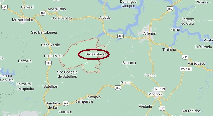
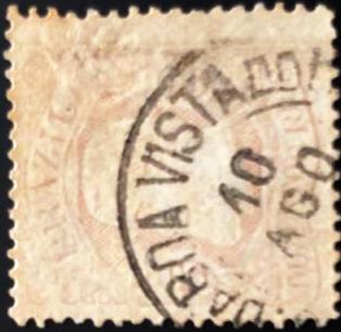
N. Sra. da Conceição da Boa Vista was originally an arraial of the Villa of Caldas, located close to the east bank of the Muzambo River, 420 south of the provincial capital Ouro Preto. The place went as a district to the Município of Alfenas in July 1864, which changed to the Município of Cabo Verde in August 1911 under the name of Conceição da Boa Vista do Cabo Verde. In September 1923, it was renamed Divisa Nova (New Border). Since December 1938, Divisa Nova has been an independent Município.
The local post office was created in November 1873, as both Paula Sobrinho in História Postal de Minas Gerais (Belo Horizonte, 1997) and R. Koester in Carimbologia XIII write.
The oldest postmark to date is CMG-0795a, found on a D. Pedro issue from 1877 (ill. Marcio Duarte):
CMG-0795a (MD) 1877ffGoogle Maps
Anderer Name: Divisa Nova (1923)
N. Sra. da Conceição da Boa Vista war ursprünglich ein Arraial der Villa von Caldas, der nah am Ostufer des Flusses Muzambo lag, 420 südlich der Provinzhauptstadt Ouro Preto entfernt. Der Ort ging als Distrikt zum Município von Alfenas im Juli 1864, der im August 1911 unter dem Namen Conceição da Boa Vista do Cabo Verde zum Município von Cabo Verde wechselte. Im September 1923 erfolgte die Umbenennung zu Divisa Nova (Neue Grenze). Seit Dezember 1938 ist Divisa Nova ein eigenständiger Município.
Das örtliche Postamt wurde im November 1873 ins Leben gerufen, wie sowohl Paula Sobrinho in História Postal de Minas Gerais (Belo Horizonte, 1997) als auch R. Koester in Carimbologia XIII schreiben.
Der bisher älteste Poststempel ist CMG-0795a, gefunden auf einer D.-Pedro-Ausgabe aus 1877 (Abb. Marcio Duarte):
Other names: Conceição do Recreio, Conceição da Boa Vista (1939)
Nossa Senhora da Conceição da Boa Vista do Recreio was a curato of the Vila de Mar d’Hespanha, 270 kilometres south-east of the provincial capital Ouro Preto. In July 1872, it was elevated to a freguesia and belonged to Vila de Leopoldina. In April 1926, the locality was renamed Conceição do Recreio and in December 1938 it went as a district to Município Recreio. Finally, in April 1939, the name was changed to Conceição da Boa Vista.
Paula Sobrinho writes in História Postal de Minas Gerais (Belo Horizonte, 1997) that there had been a post office there since March 1871. However, the directory of imperial post offices (Tabella das Agencias do Correio do Imperio (Rio de Janeiro, 1885) states the year 1882. The only postmark from the imperial era to date is CMG-0800a (ill. Luciano Gomes), which also existed in dark violet:
CMG-0800a (LG) 1880-1889Provincia de Minas Geraes, 1873
Andere Namen: Conceição do Recreio, Conceição da Boa Vista (1939)
Nossa Senhora da Conceição da Boa Vista do Recreio war ein Curato der Vila de Mar d’Hespanha, 270 km südöstlich der Provinzhauptstadt Ouro Preto. Im Juli 1872 wurde sie zur Freguesia erhoben und ging zu Vila de Leopoldina. Im April 1926 wurde die Ortschaft in Conceição do Recreio umbenannt und ging im Dezember 1938 als Distrikt zu Município Recreio. Schließlich erfolgte im April 1939 die Umbenennung in Conceição da Boa Vista.
Paula Sobrinho schreibt in História Postal de Minas Gerais (Belo Horizonte, 1997), dass es dort seit März 1871 ein Postamt gab. Im Verzeichnis der kaiserlichen Postämter (Tabella das Agencias do Correio do Imperio, Rio de Janeiro, 1885) steht aber das Jahr 1882. Der bisher einzige Poststempel aus der Kaiserzeit ist CMG-0800a (Abb. Luciano Gomes), den es auch in dunkelviolett gab:
Other names: Cassiterita, Conceição da Barra de Minas (1989)
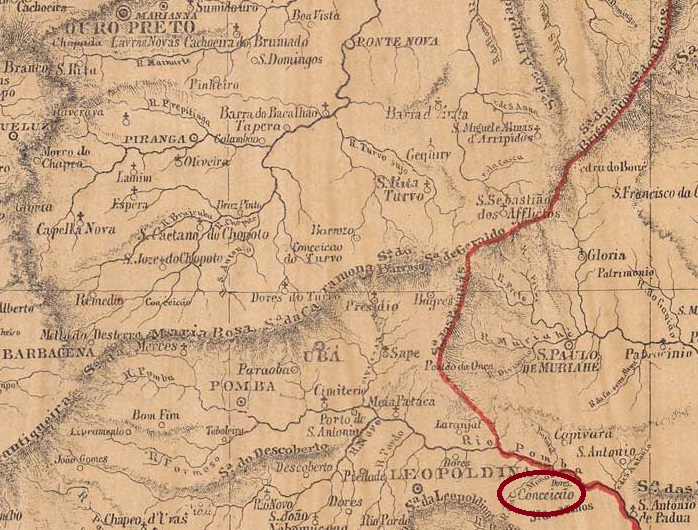
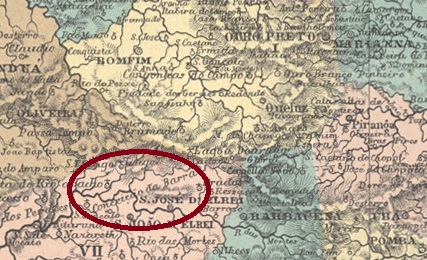
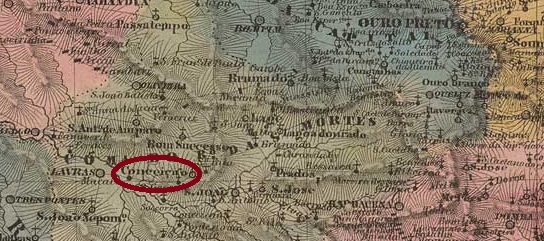
The Capela de N. Sra. da Conceição was built as early as 1725 at the confluence of the Rio das Mortes and Rio das Mortes Pequeno rivers, 200 kilometres southwest of the provincial capital of Ouro Preto. In July 1832, it was named Freguesia de N. Sra. da Conceição da Barra, which belonged to the Vila de S. João d’El-Rei. In December 1943, the place name was changed to Cassiterita, and in December 1962, the village was elevated to Município. Finally, in October 1989, the old place name returned with a slight change, to Conceição da Barra de Minas.
There had been a post office there since September 1882, as Paula Sobrinho writes in História Postal de Minas Gerais (Belo Horizonte, 1997). The only postmark of the empire to date is CMG-0790a (illustration by Claudio Neumann):
CMG-0790a (CN) 1888ff-1889Villiers de l’Ile Adam: CArta (…) da Provincia de Minas Geraes, 1849
Andere Namen: Cassiterita, Conceição da Barra de Minas (1989)
Bereits 1725 wurde am Zusammenfluss der Flüsse Rio das Mortes und Rio das Mortes Pequeno, 200 km südwestlich der Provinzhauptstadt Ouro Preto, die Capela de N. Sra. da Conceição errichtet. Im Juli 1832 wurde sie als Freguesia de N. Sra. da Conceição da Barra bezeichnet, die zur Vila de S. João d’El-Rei gehörte. Im Dezember 1943 wurde der Ortsname in Cassiterita geändert, und im Dezember 1962 wurde der Ort zum Município erhoben. Im Oktober 1989 schließlich kehrte der alte Ortsname mit einer leichten Änderung in Conceição da Barra de Minas zurück.
Ein Postamt gab es dort seit September 1882, wie Paula Sobrinho in História Postal de Minas Gerais (Belo Horizonte, 1997) schreibt. Der bisher einzige Poststempel des Kaiserreichs ist CMG-0790a (Abb. Claudio Neumann):
Other names: Barro Preto, Cachoeira do Espirito Santo, Aparecida (1924)
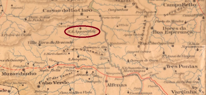
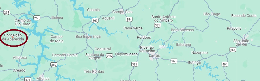
The Freguesia de N. Sra. da Conceição da Apparecida was founded in December 1879 in the area of Vila de Carmo do Rio Claro, 420 kilometres west of the provincial capital Ouro Preto. In December 1924, the place name was shortened to Aparecida and 14 years later it was extended to Conceição da Aparecida. Conceição da Aparecida has been a separate município since December 1943.
All sources agree that there has been a post office there since March 1882. This is also confirmed by the press in Rio:
O Globo/RJ, 24/03/1882
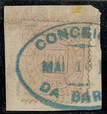
The only postmark from the imperial era to date is CMG-0785a, shown here in an illustration from R. Koester’s Carimbologia XIII:
CMG-0785a (RK) 1889Google Maps
Andere Namen: Barro Preto, Cachoeira do Espirito Santo, Aparecida (1924)
Die Freguesia de N. Sra. da Conceição da Apparecida wurde im Dezember 1879 im Gebiet der Vila de Carmo do Rio Claro, 420 km westlich der Provinzhauptstadt Ouro Preto, gegründet. Im Dezember 1924 wurde der Ortsname zu Aparecida verkürzt und 14 Jahre später zu Conceição da Aparecida erweitert. Seit Dezember 1943 ist Conceição da Aparecida ein eigenes Município.
Alle Quellen stimmen darin überein, dass es dort seit März 1882 ein Postamt gab. Dies wird auch von der Presse in Rio bestätigt:
O Globo/RJ, 24.03.1882
Der bisher einzige Poststempel aus der Kaiserzeit ist CMG-0785a, hier in einer Abbildung aus R. Koesters Carimbologia XIII:
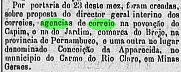
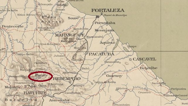
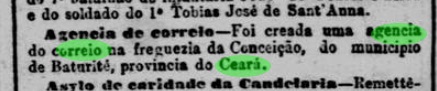
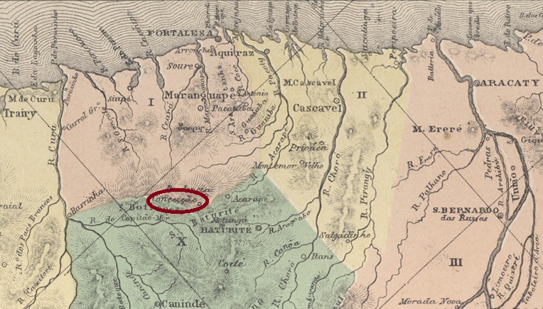
The Freguesia de N. Sra. da Conceição da Serra was founded in 1875 near Vila de Baturité, 100 kilometres south of the provincial capital Fortaleza. The parish of N. Sra. da Conceição da Pendência was established there in December 1885. It was not until August 1890 that the town was declared a district of Baturité. In August 1901, it was elevated to the Município de Pacoti. In May 1931 it was downgraded to the district of Baturité, but in December 1933 it regained the status of a município. The indigenous name is said to mean Aguti Lake.
As R. Koester writes in Carimbologia XIII, there had been a post office there since August 1888, which is confirmed by the Rio press:
Jornal do Commercio/RJ, 18/08/1888
Koester also shows the two known postmarks from the imperial era from Conceição/CE:
CCE-0115a (RK)CCE-0115b (RK) 1889Atlas do Imperio do Brasil, 1868
Andere Namen: Guaramiranga, Pacoti
1875 wurde die Freguesia de N. Sra. da Conceição da Serra in der Nähe von Vila de Baturité, 100 km südlich der Provinzhauptstadt Fortaleza, gegründet. Im Dezember 1885 wurde dort die Pfarrei N. Sra. da Conceição da Pendência errichtet. Erst im August 1890 wurde der Ort zum Distrikt im Bezirk Baturité ernannt. Im August 1901 erfolgte die Erhebung als Município de Pacoti. Im Mai 1931 wurde es zum Distrikt von Baturité herabgestuft, aber im Dezember 1933 erhielt es endgültig den Status eines Município zurück. Der indigene Name soll Aguti-See bedeuten.
Wie R. Koester in Carimbologia XIII schreibt, gab es dort seit August 1888 ein Postamt, was die Presse aus Rio bestätigen kann:
Jornal do Commercio/RJ, 18.08.1888
Koester zeigt auch die beiden bekannten Poststempel aus der Kaiserzeit aus Conceição/CE:
Carta da Republica dos Estados Unidos do Brazil, 1892
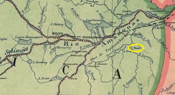
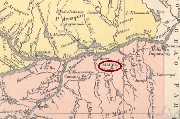
Other names: Uacituba, Luséa, Maués (1858-1865, 1892)
Since 1798 there had been a settlement called Luséa on the east bank of the Maués, 260 kilometres east of the later provincial capital of Manaus. Today, it still takes one day and seven hours to travel this distance along the Amazon. At that time, the later province of Amazonas still belonged to the Capitania do Grão-Pará. In June 1833, it was elevated to the status of Vila. After the founding of the imperial province of Amazonas, the town – downgraded to a freguesia – was renamed Maués in November 1858. But by September 1865, it had already become the Vila de N. Sra. da Conceição. The name Maués returned in November 1892 and in May 1895 Maués became a town.
Three dates have been found for the foundation of the local postal agency. For the first time in March 1846, as Nova Monteiro writes in Administrações e Agencias Postaes do Brasil Imperio (Brasil Filatelico/RJ, 1934-5; reprint SPP 1994-1999), and confirmed by the Imperial Yearbook 1846:
Annuario Politico, Historico e Estatatistico do Brazil, 1846
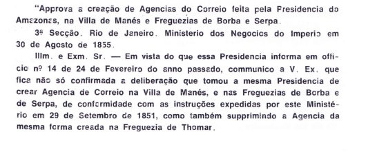
The second post offfice opening took place in August 1855, as reported by Aureo G. Santos in Agências de Correio Criadas e Suprimidas 1851, 1855, 1856 e 1857 (Brasil Filatélico 181, Rio de Janeiro, 1977):
Aureo G. Santos (op. cit.)
There is also said to have been a post office in Maués in 1860, as can be seen from the Directory of Imperial Post Offices /Tabella das Agencias do Correio do Imperio (Rio de Janeiro, 1885). The only postmark to date with the place name Conceição is CAM-0040c (RK) and is said to be already republican, as R. Koester writes in Carimbologia XII:
CAM-0040c (RK)Atlas do Imperio do Brasil, 1868
Andere Namen: Uacituba, Luséa, Maués (1858-1865, 1892)
Seit 1798 gab es eine Siedlung namens Luséa am Ostufer des Maués, 260 km östlich der späteren Provinzhauptstadt Manaus. Für diese Entfernung benötigt man heute noch einen Tag und sieben Stunden Reisezeit entlang des Amazonas. Damals gehörte die spätere Provinz Amazonas noch zur Capitania do Grão-Pará. Im Juni 1833 erfolgte die Erhebung zur Vila. Nach der Gründung der Kaiserprovinz Amazonas wurde der Ort – zur Freguesia herabgestuft – im November 1858 in Maués umbenannt. Aber schon im September 1865 wurde daraus die Vila de N. Sra. da Conceição. Der Name Maués kehrte im November 1892 zurück und im Mai 1895 wurde Maués zur Stadt.
Für die Gründung der örtlichen Postagentur wurden drei Daten gefunden. Zum ersten Mal im März 1846, wie Nova Monteiro in Administrações e Agencias Postaes do Brasil Imperio (Brasil Filatelico/RJ, 1934-5; Nachdruck SPP 1994-1999) schreibt, und bestätigt durch das Kaiserliche Jahrbuch 1846:
Annuario Politico, Historico e Estatatistico do Brazil, 1846
Die zweite Posteröffnung fand im August 1855 statt, wie Aureo G. Santos in Agências de Correio Criadas e Suprimidas 1851, 1855, 1856 e 1857 (Brasil Filatélico 181, Rio de Janeiro, 1977) berichtet:
Aureo G. Santos (op. cit.)
In Maués soll es auch 1860 ein Postamt entstanden, wie aus dem Verzeichnis der kaiserlichen Postämter /Tabella das Agencias do Correio do Imperio (Rio de Janeiro, 1885) hervorgeht. Der bisher einzige Poststempel mit dem Ortsnamen Conceição ist CAM-0040c (RK) und soll bereits republikanisch sein, wie R. Koester in Carimbologia XII schreibt:
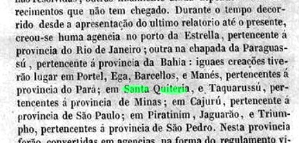
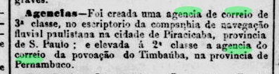
Towards the end of the 19th century, there were three shipping companies in the province (or state) of São Paulo with similar names that were dedicated to inland navigation. The Cia. de Navegação Fluvial Paulista travelled the Tietê and Piracicaba rivers. The Cia. de E.F. e Navegação Fluvial Paulista was apparently a subsidiary of the railway company of the same name and navigated the Mogi-Guaçu. Later, the Cia. de Navegação Fluvial Sul-Paulista was also founded in Santos, which was dedicated to the transport routes in the south of São Paulo. According to previous findings, only the first shipping company mentioned operated its own post office in the empire.
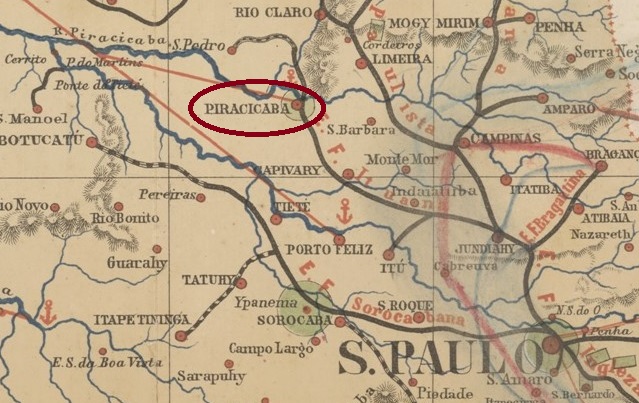
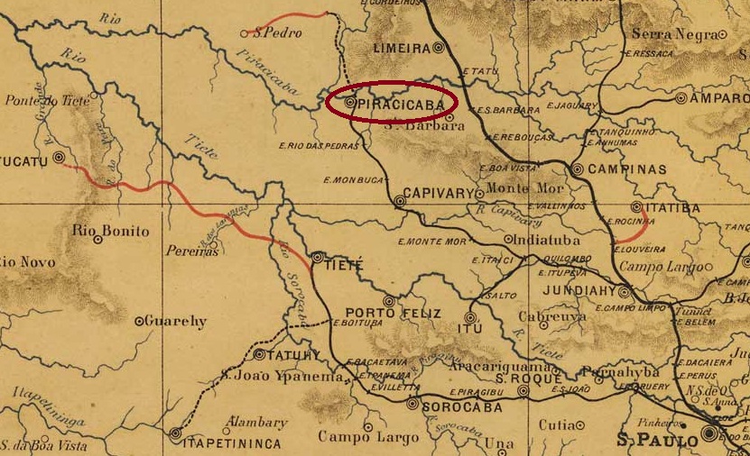
The Cia. de Navegação Fluvial Paulista was founded in the provincial capital in September 1873, but had its headquarters in Piracicaba. In July 1882, the postal agency was opened on the company’s premises, as reported in the Rio press:
Jornal do Commercio/RJ, 16/07/1882
This post office closed in March 1888, as also reported in the press:
Cidade do Rio, 09/03/1888
Around 1900, the Cia. de Navegação Fluvial Paulista disappeared from the newspapers, presumably over-indebted and insolvent. To this day, no postmark of the shipping office has been found.
J. M. Ribeiro Lisboa: Provincia de São Paulo, 1884
Andere Namen: Escriptorio da Cia. Fluvial
Gegen Ende des 19. Jahrhunderts gab es in der Provinz (bzw. im Staat) São Paulo drei Reedereien mit ähnlichen Namen, die sich der Binnenschifffahrt widmeten. Die Cia. de Navegação Fluvial Paulista befuhr die Flüsse Tietê und Piracicaba. Die Cia. Paulista de E.F. e Navegação Fluvial war anscheinend eine Tochtergesellschaft der gleichnamigen Eisenbahngesellschaft und befuhr den Mogi-Guaçu. Später wurde in Santos auch die Cia. de Navegação Fluvial Sul-Paulista gegründet, die sich den Transportstrecken im Süden von São Paulo widmete. Nach bisherigen Erkenntnissen betrieb nur die erstgenannte Schifffahrtsgesellschaft ein eigenes Postamt im Kaiserreich.
Die Cia. de Navegação Fluvial Paulista wurde im September 1873 in der Provinzhauptstadt gegründet, hatte aber ihren Sitz in Piracicaba. Im Juli 1882 wurde die Postagentur in den Räumlichkeiten des Unternehmens eröffnet, wie die Presse in Rio berichtete:
Jornal do Commercio/RJ, 16.07.1882
Dieses Postamt schloss im März 1888, wie ebenfalls aus der Presse hervorgeht:
Cidade do Rio, 09.03.1888
Um 1900 verschwand die Cia. de Navegação Fluvial Paulista aus den Presseberichten, vermutlich überschuldet und zahlungsunfähig. Bis heute wurde kein Poststempel des Schifffahrtsbüros gefunden.
Estações (…) do Rio de Janeiro, São Paulo e Minas Gerais, 1880
Other names: Sebastião de Lacerda (1931)
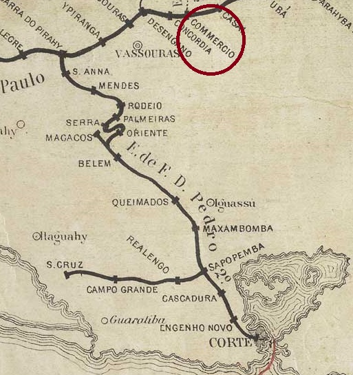
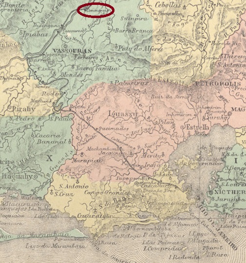
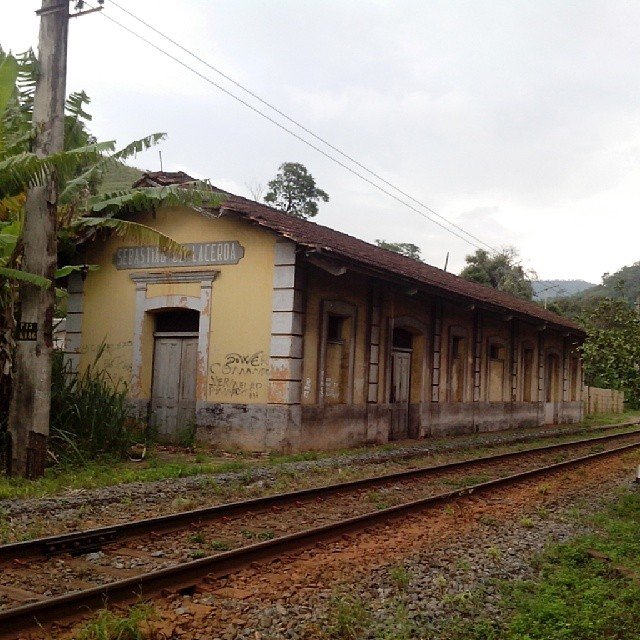
Commercio station was opened in November 1866 by the railway company E.F. D. Pedro II (Central Line) and was located near Vila de Vassouras on the south bank of the Paraíba do Sul, 150 km north-west of the capital Rio de Janeiro. The line was transferred to E.F. Central do Brasil in 1889 and belonged to Rede Ferroviária Federal S.A. from 1975 until its closure in 1996 (estacoesferroviarias.com.br). The tracks are still there today, but the station building is closed.
In 1908 (Photo: Marco Giffoni, on estacoesferroviarias.com.br)In 2014 (Photo: Jorge Alves Ferreira, on estacoesferroviarias.com.br)
The area around the railway station was declared Distrito de Commercio in October 1910 and renamed Distrito de Sebastião de Lacerda three months later. Born in Vassouras, Sebastião Eurico Gonçalves de Lacerda (1864-1925) was the Brazilian Minister of Transport (1897-8). He is the grandfather of the politician Carlos Lacerda (1914-1977), the railway station was named after Sebastião de Lacerda in August 1931.
Sebastião de Lacerda (Wikipedia)
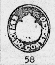
According to consistent sources, a post office had existed at Commercio station since April 1867. R. Koester shows the first postmark CRJ-0350a in Carimbologia XII:
CRJ-0350a (RK) 1867-1876
Koester also showed the postmark CRJ-0350b, unfortunately without further details:
CRJ-0350b (RK)
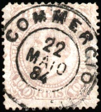
This was followed by the double circle CRJ-0350c (fig. Claudio Coelho):
CRJ-0350c (CC) 1878-1888
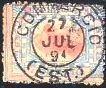
At the end of the Empire, CRJ-0350d also arrived (Fig. agenciaspostais.com.br)
CRJ-0350d (PN) 1889-1897
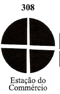
James Dingler and Klerman W. Lopes have illustrated in Mute Cancellations of the Brazil Empire / Carimbos Mudos do Brasil Império (Brazil Philatelic Association, Rio de Janeiro, 2000) a mute cancellation from the Commercio station under no. 308:
BPA 308, 1876Atlas do Imperio do Brasil, 1868
Andere Namen: Sebastião de Lacerda (1931)
Der Bahnhof Commercio wurde im November 1866 von der Eisenbahngesellschaft E.F. D. Pedro II (Hauptslinie) eröffnet und lag in der Nähe von Vila de Vassouras am Südufer des Paraíba do Sul, 150 km nordwestlich der Hauptstadt Rio de Janeiro. Die Strecke ging 1889 an die E.F. Central do Brasil über und gehörte von 1975 bis zu ihrer Stilllegung 1996 der Rede Ferroviária Federal S.A. (estacoesferroviarias.com.br). Heute sind die Gleise noch vorhanden, das Bahnhofsgebäude ist geschlossen.
1908 (Foto: Marco Giffoni, auf estacoesferroviarias.com.br)2014 (Foto: Jorge Alves Ferreira, auf estacoesferroviarias.com.br)
Das Gebiet um den Bahnhof wurde im Oktober 1910 zum Distrito de Commercio erklärt und drei Monate später in Distrito de Sebastião de Lacerda umbenannt. Der in Vassouras geborene Sebastiao Eurico Gonçalves de Lacerda (1864-1925) war brasilianischer Verkehrsminister (1897-8). Er ist der Großvater des Politikers Carlos Lacerda (1914-1977), nach ihm ist der Bahnhof im August 1931 benannt worden.
Sebastião de Lacerda (Wikipedia)
Nach übereinstimmenden Quellen existierte ein Postamt im Bahnhof Commercio seit April 1867. R. Koester zeigt in Carimbologia XII den ersten Poststempel CRJ-0350a:
CRJ-0350a (RK) 1867-1876
Koester zeigte auch den Stempel CRJ-0350b, leider ohne weitere Details:
CRJ-0350b (RK)
Es folgte der Doppelkreis CRJ-0350c (Abb. Claudio Coelho):
CRJ-0350c (CC) 1878-1888
Am Ende des Kaiserreichs kam auch CRJ-0350d (Abb. agenciaspostais.com.br)
CRJ-0350d (PN) 1889-1897
James Dingler und Klerman W. Lopes haben in Mute Cancellations of the Brazil Empire / Carimbos Mudos do Brasil Império (Brazil Philatelic Association, Rio de Janeiro, 2000) einen stummen Stempel aus der Station Commercio unter Nr. 308 abgebildet: